Jefferson County, Alabama facts for kids
Quick facts for kids
Jefferson County
|
||
|---|---|---|

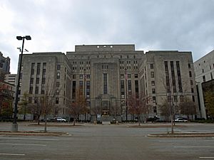
Jefferson County Courthouse in Birmingham
|
||
|
||

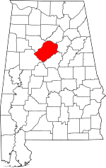
Location within the U.S. state of Alabama
|
||
 Alabama's location within the U.S. |
||
| Country | ||
| State | ||
| Founded | December 13, 1819 | |
| Named for | Thomas Jefferson | |
| Seat | Birmingham | |
| Largest city | Birmingham | |
| Area | ||
| • Total | 1,124 sq mi (2,910 km2) | |
| • Land | 1,111 sq mi (2,880 km2) | |
| • Water | 13 sq mi (30 km2) 1.1% | |
| Population
(2020)
|
||
| • Total | 674,721 | |
| • Estimate
(2023)
|
662,895 |
|
| • Density | 600.29/sq mi (231.77/km2) | |
| Time zone | UTC−6 (Central) | |
| • Summer (DST) | UTC−5 (CDT) | |
| Congressional districts | 6th, 7th | |
|
||
Jefferson County is the county with the most people in the state of Alabama. It is located in the middle part of Alabama. In 2020, about 674,721 people lived there. The main city, or county seat, is Birmingham. This county grew very fast in the 1900s because of its factories that made steel and iron. Jefferson County is the main part of the Birmingham-Hoover area.
Contents
History of Jefferson County
Jefferson County was created on December 13, 1819, by the Alabama Legislature. It was named after Thomas Jefferson, who was a former U.S. President. The county is in the north-central part of Alabama. It sits at the southern edge of the Appalachian Mountains. This area was once a big center for mining iron, coal, and limestone.
Jefferson County covers about 1,119 square miles (2,898 square kilometers) of land. Over time, the main city of the county, called the county seat, changed. It was first Carrollsville from 1819 to 1821. Then it moved to Elyton from 1821 to 1873.
How Birmingham Became the County Seat
Birmingham was started around 1871. In 1873, it became the new county seat. The city was named after a famous city in England that was also known for making iron and steel. Birmingham grew by joining with nearby towns and villages, like Elyton.
As Birmingham's factories grew, more people moved there. Many people, both Black and White, came from farms to find new jobs. Immigrants from Europe also came to the city. Even though Birmingham grew quickly, it did not have enough power in the state government for a long time. This meant its needs were not always met.
Changes and Challenges in the County
In the late 1800s, there were many tensions between different racial groups. State laws were passed that made it harder for Black people and some poor White people to vote. This meant they had less say in how the county was run.
Even after 1950, there was still violence against Black people, especially as they worked for equal rights. In the 1950s, some groups bombed Black homes. Because of this, Birmingham was sometimes called "Bombingham."
In 1963, the city agreed to let Black people use public places and get more jobs. This happened after peaceful protests led by people from the 16th Street Baptist Church. However, in September 1963, members of a hate group bombed the church. Four young Black girls were killed, and many people were hurt. The community quickly rebuilt the church.
County Finances and Bankruptcy
On November 9, 2011, Jefferson County had to file for bankruptcy. This meant the county had too much debt, especially from sewer projects. It was one of the largest county bankruptcies in U.S. history at that time. To fix this, the county cut many expenses and reduced the number of government workers.
Geography of Jefferson County
Jefferson County has a total area of about 1,124 square miles (2,911 square kilometers). About 1,111 square miles (2,877 square kilometers) is land, and 13 square miles (34 square kilometers) is water. This means about 1.1% of the county is water. It is the fifth-largest county in Alabama by land area. The county is also home to the Watercress Darter National Wildlife Refuge.
Neighboring Counties
Jefferson County shares borders with these other counties:
- Tuscaloosa County (to the west)
- Bibb County (to the southwest)
- Shelby County (to the south)
- Walker County (to the north)
- Blount County (to the north)
- St. Clair County (to the northeast)
Population and People
| Historical population | |||
|---|---|---|---|
| Census | Pop. | %± | |
| 1830 | 6,855 | — | |
| 1840 | 7,131 | 4.0% | |
| 1850 | 8,989 | 26.1% | |
| 1860 | 11,746 | 30.7% | |
| 1870 | 12,345 | 5.1% | |
| 1880 | 23,272 | 88.5% | |
| 1890 | 88,501 | 280.3% | |
| 1900 | 140,420 | 58.7% | |
| 1910 | 226,476 | 61.3% | |
| 1920 | 310,054 | 36.9% | |
| 1930 | 431,493 | 39.2% | |
| 1940 | 459,930 | 6.6% | |
| 1950 | 558,928 | 21.5% | |
| 1960 | 634,864 | 13.6% | |
| 1970 | 644,991 | 1.6% | |
| 1980 | 671,371 | 4.1% | |
| 1990 | 651,525 | −3.0% | |
| 2000 | 662,047 | 1.6% | |
| 2010 | 658,466 | −0.5% | |
| 2020 | 674,721 | 2.5% | |
| 2023 (est.) | 662,895 | 0.7% | |
| U.S. Decennial Census 1790–1960 1900–1990 1990–2000 2010–2020 |
|||
In 2020, the population of Jefferson County was 674,721 people. There were 274,699 households and 170,971 families living in the county. The population density was about 607 people per square mile.
Who Lives in Jefferson County?
| Race / Ethnicity (NH = Non-Hispanic) | Pop 2000 | Pop 2010 | Pop 2020 | % 2000 | % 2010 | % 2020 |
|---|---|---|---|---|---|---|
| White alone (NH) | 379,707 | 340,213 | 324,252 | 57.35% | 51.67% | 48.06% |
| Black or African American alone (NH) | 259,623 | 275,511 | 280,112 | 39.22% | 41.84% | 41.52% |
| Native American or Alaska Native alone (NH) | 1,314 | 1,431 | 1,207 | 0.20% | 0.22% | 0.18% |
| Asian alone (NH) | 5,909 | 9,085 | 13,043 | 0.89% | 1.38% | 1.93% |
| Pacific Islander alone (NH) | 125 | 154 | 311 | 0.02% | 0.02% | 0.05% |
| Some Other Race alone (NH) | 367 | 531 | 1,966 | 0.29% | 0.08% | 0.29% |
| Mixed Race or Multi-Racial (NH) | 4,718 | 6,053 | 18,974 | 0.71% | 0.92% | 2.81% |
| Hispanic or Latino (any race) | 10,284 | 25,488 | 34,856 | 1.55% | 3.87% | 5.17% |
| Total | 662,047 | 658,466 | 674,721 | 100.00% | 100.00% | 100.00% |
According to the 2020 census, the population of Jefferson County included:
- About 48% White people (not Hispanic or Latino)
- About 41.5% Black or African American people (not Hispanic or Latino)
- About 5.2% Hispanic or Latino people (who can be of any race)
- Other groups like Asian, Native American, and people of two or more races make up smaller parts of the population.
Religion in the County
In 2010, the largest religious group in Jefferson County was the Southern Baptist Convention (SBC). They had over 185,000 members. Other large groups included non-denominational Christians, National Baptist Convention, and Catholics. Many other Christian groups also have churches in the county.
Education in Jefferson County
Jefferson County has many different school districts. Some cities have their own school systems, while other areas are served by the Jefferson County School District.
School Districts in the County
- Bessemer City School District
- Birmingham City School District
- Fairfield City School District
- Homewood City School District
- Hoover City School District
- Leeds City School District
- Jefferson County School District
- Midfield City School District
- Mountain Brook City School District
- Tarrant City School District
- Trussville City School District
- Vestavia Hills City School District
History of Schools
For a long time, schools in Alabama were separated by race. In 1954, the U.S. Supreme Court said that this was against the law. But it took many years for schools in Jefferson County to become fully integrated. By 1969, all public schools in the county were integrated.
Over time, some wealthier towns in the county started their own school systems. This sometimes led to differences in funding and resources between schools.
Getting Around Jefferson County
Jefferson County has many ways to travel, including major highways, railroads, and an airport.
Main Roads
 Interstate 20
 Interstate 22
 Interstate 59
 Interstate 65
 Future Interstate 222
 Future Interstate 422
 Interstate 459
 U.S. Route 11
 U.S. Route 31
 U.S. Route 78
 U.S. Route 280
 U.S. Route 411
 State Route 5
 State Route 25
 State Route 75
 State Route 79
 State Route 119
 State Route 149
 State Route 150
 State Route 151
 State Route 269
 State Route 378
Trains and Air Travel
You can travel by train through Jefferson County on the Crescent line, which stops in Birmingham. There are also several companies that transport goods by train.
The Birmingham-Shuttlesworth International Airport is located in Birmingham. It offers flights to many places across the United States.
Cities, Towns, and Communities
Jefferson County has many different cities, towns, and smaller communities.
Cities in Jefferson County
- Adamsville
- Bessemer
- Birmingham (county seat; partly in Shelby County)
- Brighton
- Center Point
- Clay
- Fairfield
- Fultondale
- Gardendale
- Graysville
- Helena (partly in Shelby County)
- Homewood
- Hoover (partly in Shelby County)
- Hueytown
- Irondale
- Kimberly
- Leeds (partly in Shelby County and St. Clair County)
- Lipscomb
- Midfield
- Mountain Brook
- Pinson
- Pleasant Grove
- Tarrant
- Trussville (partly in St. Clair County)
- Vestavia Hills (partly in Shelby County)
- Warrior
Towns in Jefferson County
- Argo (partly in St. Clair County)
- Brookside
- Cardiff
- County Line (partly in Blount County)
- Maytown
- Morris
- Mulga
- North Johns
- Sylvan Springs
- Trafford
- West Jefferson
Census-Designated Places
These are areas that are like towns but are not officially incorporated as cities or towns.
Unincorporated Communities
These are smaller communities that are not part of any city or town.
Former Towns
- Elyton (This was once the county seat, but it is now a neighborhood in Birmingham.)
- Ensley (This was also a town that is now a neighborhood in Birmingham.)
See also
 In Spanish: Condado de Jefferson (Alabama) para niños


