
Kanawha County, West Virginia facts for kids
Quick facts for kids
Kanawha County
|
|||
|---|---|---|---|

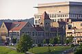
Kanawha County Courthouse in Charleston
|
|||
|
|||

Location within the U.S. state of West Virginia
|
|||
 West Virginia's location within the U.S. |
|||
| Country | |||
| State | |||
| Founded | October 5, 1789 | ||
| Named for | Kanawha River | ||
| Seat | Charleston | ||
| Largest city | Charleston | ||
| Area | |||
| • Total | 911 sq mi (2,360 km2) | ||
| • Land | 902 sq mi (2,340 km2) | ||
| • Water | 9.3 sq mi (24 km2) 1.0%% | ||
| Population
(2020)
|
|||
| • Total | 180,745 | ||
| • Estimate
(2021)
|
177,952 |
||
| • Density | 198.40/sq mi (76.60/km2) | ||
| Time zone | UTC−5 (Eastern) | ||
| • Summer (DST) | UTC−4 (EDT) | ||
| Congressional district | 1st | ||


Kanawha County is a county in the state of West Virginia. It is the most populated county in West Virginia. In 2020, about 180,745 people lived here. The main city and county seat is Charleston. Charleston is also the capital city of West Virginia.
Kanawha County is part of the larger Charleston, WV Metropolitan Statistical Area.
Contents
History of Kanawha County
Kanawha County was officially created on October 5, 1789. It was named after the Kanawha River. The river itself was named after a Native American tribe that once lived in this area.
During the American Civil War, many soldiers from Kanawha County joined the fight. They formed groups for both the Confederate Army and the Union Army.
In 1863, West Virginia counties were divided into smaller areas called townships. This was to help local governments. Later, in 1872, these townships became "magisterial districts." These districts helped manage local affairs. Over time, the number of districts changed. Today, Kanawha County has four main magisterial districts.
Kanawha County has also been the site of important events. In 1912, there was a large strike by miners. In 1974, a disagreement over school textbooks gained national attention.
Geography and Nature
Kanawha County covers a total area of about 911 square miles. Most of this area, about 902 square miles, is land. The rest, about 9.3 square miles, is water. This makes it the fourth-largest county in West Virginia by land area.
Neighboring Counties
Kanawha County shares its borders with several other counties:
- Roane County (north)
- Clay County (northeast)
- Nicholas County (east)
- Fayette County (east)
- Raleigh County (southeast)
- Boone County (south)
- Lincoln County (southwest)
- Putnam County (west)
- Jackson County (northwest)
Main Roads and Highways
Several important roads and highways pass through Kanawha County:
 Interstate 64
 Interstate 77
 Interstate 79
 U.S. Route 60
 U.S. Route 119
 West Virginia Route 4
 West Virginia Route 25
 West Virginia Route 34
 West Virginia Route 61
 West Virginia Route 62
 West Virginia Route 94
 West Virginia Route 114
 West Virginia Route 214
 West Virginia Route 501
 West Virginia Route 601
 West Virginia Route 622
 West Virginia Route 817
People and Population
| Historical population | |||
|---|---|---|---|
| Census | Pop. | %± | |
| 1800 | 3,239 | — | |
| 1810 | 3,866 | 19.4% | |
| 1820 | 6,399 | 65.5% | |
| 1830 | 9,326 | 45.7% | |
| 1840 | 13,567 | 45.5% | |
| 1850 | 15,353 | 13.2% | |
| 1860 | 16,150 | 5.2% | |
| 1870 | 22,349 | 38.4% | |
| 1880 | 32,466 | 45.3% | |
| 1890 | 42,756 | 31.7% | |
| 1900 | 54,696 | 27.9% | |
| 1910 | 81,457 | 48.9% | |
| 1920 | 119,650 | 46.9% | |
| 1930 | 157,667 | 31.8% | |
| 1940 | 195,619 | 24.1% | |
| 1950 | 239,629 | 22.5% | |
| 1960 | 252,925 | 5.5% | |
| 1970 | 229,515 | −9.3% | |
| 1980 | 231,414 | 0.8% | |
| 1990 | 207,619 | −10.3% | |
| 2000 | 200,073 | −3.6% | |
| 2010 | 193,063 | −3.5% | |
| 2020 | 180,745 | −6.4% | |
| 2023 (est.) | 174,805 | −9.5% | |
| U.S. Decennial Census 1790–1960 1900–1990 1990–2000 2010–2020 |
|||
Population in 2020
In 2020, Kanawha County had 180,745 people. There were 77,634 households. Most people (85%) were White. About 7.5% were African American, and 1.2% were Asian. A small number were Native American or from other backgrounds. About 1.6% of the population was Hispanic or Latino.
The average age in the county was 43.7 years. About 20.2% of the people were under 18 years old. The average income for a household was $56,112.
Economy and Jobs
In 2010, there were about 5,481 private businesses in Kanawha County. Nearly 90,000 people who live in the county have jobs.
Fun and Recreation
Kanawha County offers many parks and golf courses for outdoor fun.
| Parks | Golf |
|---|---|
| Coonskin Park | Coonskin Golf Course |
| Shawnee Park | Shawnee Golf Course |
| Meadowood Park | Edgewood Country Club |
| Pioneer Park | Little Creek Golf Course |
| Wallace Hartman Nature Preserve | Sleepy Hollow Golf Club |
| Cato Park | Sandy Brae Golf Course |
| Ridenour Park | Berry Hills Country Club |
| Big Bend Park | Big Bend Golf Course |
| Kanawha State Forest | |
| Saint Albans City Park |
Events and Festivals
Many exciting events happen in Kanawha County throughout the year:
- FestivALL
- Charleston Sternwheel Regatta (Returning 2022)
- Live on the Levee
- Vandalia Gathering
- Rib Fest
- Charleston Rod Run Doo Wop
- Majorette Festival - Daily Mail Kanawha County Majorette and Band Festival
- Pinch Reunion
- St. Albans Festival of Lights
Places to Visit
There are several interesting attractions in Kanawha County:
- Clay Center (West Virginia) - A science and arts center.
- West Virginia State Capitol - The state government building.
- West Virginia Cultural Center - Learn about West Virginia's history and culture.
- South Charleston Mound - An ancient Native American mound.
- Mardi Gras Casino and Resort
- Charleston Civic Center - A large event venue.
- Heritage Tower Museum
Sports Teams
Kanawha County is home to a few sports teams:
- Charleston Dirty Birds - A baseball team.
- West Virginia United - A soccer club.
Communities in Kanawha County
Kanawha County has several cities, towns, and other communities.
Cities
- Charleston (the county seat)
- Dunbar
- Marmet
- Montgomery (partly in this county)
- Nitro (partly in this county)
- Smithers (partly in this county)
- South Charleston
- St. Albans
Towns
Magisterial Districts
These are the local government areas within the county:
- District 1
- District 2
- District 3
- District 4
Census-Designated Places
These are areas that are like towns but are not officially incorporated:
- Alum Creek (part)
- Big Chimney
- Chelyan
- Coal Fork
- Cross Lanes
- Elkview
- Jefferson
- Pinch
- Rand
- Shrewsbury
- Sissonville
- Tornado
Famous People from Kanawha County
Many notable people have come from Kanawha County:
- Robert Alexander, NFL football player
- Anthony Bass, NFL football player
- George Crumb, a well-known composer
- Aaron Dobson, Super Bowl champion football player
- Ryan Dorsey, actor
- Jon Elmore, NBA basketball player
- Conchata Ferrell, actress (known for Berta on Two and a Half Men)
- Jennifer Garner, actress and award winner
- Elizabeth Harden Gilmore, business leader and civil rights supporter
- Gary Gregor, NBA basketball player
- Alex Hawkins, two-time NFL champion football player
- Alexis Hornbuckle, two-time WNBA champion basketball player
- T. D. Jakes, a famous pastor
- Carl Lee, NFL football player
- Earl Lloyd, Basketball Hall of Fame member and the first African-American to play in an NBA game
- Kathy Mattea, country and bluegrass singer
- Ann Magnuson, actress and performance artist
- Renee Montgomery, two-time WNBA champion basketball player
- Randy Moss, Pro Football Hall of Fame member and NFL record holder
- Lou Myers, actor (known for Vernon Gaines on A Different World)
- Les Palmer, NFL champion football player
- Phil Pfister, strongman competitor and winner of the 2006 World's Strongest Man
- Kristen Ruhlin, actress
- Ryan Switzer, NFL football player
- Booker T. Washington, a very important educator and author
- Jerry West, Basketball Hall of Fame member and the person on the NBA logo
- Jason Williams, NBA basketball player
Images for kids
-

Seal of Kanawha County
-
The Kanawha County Courthouse in Charleston
-

Flag of Kanawha County
See also
 In Spanish: Condado de Kanawha para niños
