
Kitsap County, Washington facts for kids
Quick facts for kids
Kitsap County
|
|
|---|---|

Kitsap County Courthouse
|
|

Location within the U.S. state of Washington
|
|
 Washington's location within the U.S. |
|
| Country | |
| State | |
| Founded | January 16, 1857 |
| Named for | Chief Kitsap |
| Seat | Port Orchard |
| Largest city | Bremerton |
| Area | |
| • Total | 566 sq mi (1,470 km2) |
| • Land | 395 sq mi (1,020 km2) |
| • Water | 171 sq mi (440 km2) 30%% |
| Population
(2020)
|
|
| • Total | 275,611 |
| • Estimate
(2023)
|
277,658 |
| • Density | 644/sq mi (249/km2) |
| Time zone | UTC−8 (Pacific) |
| • Summer (DST) | UTC−7 (PDT) |
| Congressional district | 6th |
Kitsap County is a county in the U.S. state of Washington. As of the 2020 census, about 275,611 people live here. Its main government office, called the county seat, is in Port Orchard. The biggest city in the county is Bremerton.
Kitsap County was created on January 16, 1857, from parts of King County and Jefferson County. It is named after Chief Kitsap of the Suquamish Tribe. The county was first called Slaughter County, but its name was quickly changed.
Kitsap County is part of a larger area known as the Bremerton–Silverdale–Port Orchard, WA Metropolitan Statistical Area. This area is also included in the bigger Seattle–Tacoma, WA Combined Statistical Area.
The United States Navy is the largest employer in Kitsap County. It has important bases here, including Puget Sound Naval Shipyard, Naval Undersea Warfare Center Keyport, and Naval Base Kitsap. Naval Base Kitsap includes the former NSB Bangor and NS Bremerton.
Kitsap County is connected to the eastern side of Puget Sound by Washington State Ferries. These ferries offer routes like the Seattle-Bremerton Ferry, and connections from Southworth to West Seattle (via Vashon Island). There are also ferries from Bainbridge Island to Downtown Seattle, and from Kingston to Edmonds, Washington. Kitsap Transit also runs fast ferry services for passengers between Bremerton and Seattle, Kingston and Seattle, and Southworth and Seattle.
Contents
History of Kitsap County
The land that makes up the Kitsap Peninsula was bought by the U.S. Government from Native American tribes. This happened through three important agreements called treaties:
- The Treaty of Medicine Creek, signed on December 26, 1854.
- The Treaty of Point Elliott, signed on January 22, 1855.
- The Point No Point Treaty, signed on January 26, 1855.
Isaac Stevens, who was the governor of the Washington Territory at the time, represented the United States in all these discussions.
When the Washington Territory was set up in 1853, the Kitsap Peninsula was split between King County (to the east) and Jefferson County (to the west). This meant that people living on the Peninsula had to travel all the way to Seattle or Port Townsend to file official papers. To make things easier, two mill owners, George Anson Meigs and William Renton, supported their employees, Timothy Duane Hinckley and S.B. Wilson, to run for the Territorial Legislature. They hoped these men would help create a new county closer to home.
Once in Olympia, the two men suggested creating a new county called "Madison." However, another representative suggested naming it "Slaughter" to honor Lt. William Alloway Slaughter, who had died in a conflict in 1855. The bill passed with the name "Slaughter." Governor Isaac Stevens signed it on January 16, 1857. The county seat, or main government town, was set up in Meigs's mill town, Port Madison.
In the first election for Slaughter County on July 13, 1857, voters had a chance to rename the county. They could choose "Mill," "Madison," or "Kitsap." "Slaughter" was not an option. "Kitsap" won by a huge number of votes, and that's how the county got its current name.
Kitsap County is home to several large United States Navy bases, which are now all part of Naval Base Kitsap. The county grew a lot during the 20th century because of wars and conflicts. For example, Bremerton, where the Puget Sound Naval Shipyard is located, had about 80,000 residents during World War II. Naval Submarine Base Bangor was built in the 1980s to store nuclear weapons for submarines. This base helped the county's population grow from 147,000 to 190,000 in that decade.
Geography and Natural Features

Kitsap County covers a total area of about 566 square miles (1,466 square kilometers). About 395 square miles (1,023 square kilometers) of this is land, and 171 square miles (443 square kilometers) is water. This means about 30% of the county is water. It is one of the smallest counties in Washington state by land area.
The county covers most of the Kitsap Peninsula. It also includes two islands: Bainbridge Island and Blake Island. Kitsap County has over 250 miles (400 kilometers) of saltwater shoreline.
The northern part of the county, north of Silverdale, is often called North Kitsap. The southern part, south of Bremerton, is known as South Kitsap.
Important Waterways and Landforms
- Bainbridge Island
- Blake Island
- Buck Lake
- Colvos Passage
- Dyes Inlet
- Hood Canal
- Kitsap Peninsula
- Liberty Bay
- Port Gamble
- Port Madison
- Port Orchard
- Puget Sound
- Sinclair Inlet
- Blue Hills
- Seattle Fault Zone
- Kitsap Lake
- Ostrich Bay
- Horseshoe Lake
Neighboring Counties
Kitsap County shares borders with these other counties:
- Island County - to the northeast
- Snohomish County - to the east
- King County - to the east and southeast
- Pierce County - to the south and southeast
- Mason County - to the southwest
- Jefferson County - to the northwest
Population and People
| Historical population | |||
|---|---|---|---|
| Census | Pop. | %± | |
| 1860 | 544 | — | |
| 1870 | 866 | 59.2% | |
| 1880 | 1,738 | 100.7% | |
| 1890 | 4,624 | 166.1% | |
| 1900 | 6,767 | 46.3% | |
| 1910 | 17,647 | 160.8% | |
| 1920 | 33,162 | 87.9% | |
| 1930 | 30,776 | −7.2% | |
| 1940 | 44,387 | 44.2% | |
| 1950 | 75,724 | 70.6% | |
| 1960 | 84,176 | 11.2% | |
| 1970 | 101,732 | 20.9% | |
| 1980 | 147,152 | 44.6% | |
| 1990 | 189,731 | 28.9% | |
| 2000 | 231,969 | 22.3% | |
| 2010 | 251,133 | 8.3% | |
| 2020 | 275,611 | 9.7% | |
| 2023 (est.) | 277,658 | 10.6% | |
| U.S. Decennial Census 1790–1960 1900–1990 1990–2000 2010–2020 |
|||
Population in 2020
According to the 2020 census, there were 275,611 people living in Kitsap County. There were 105,803 households and 71,548 families.
Population in 2010
In the 2010 census, the county had 251,133 people. The population density was about 636 people per square mile. Most people (82.6%) were white. Other groups included Asian (4.9%), Black or African American (2.6%), and American Indian (1.6%). About 6.2% of the population was of Hispanic or Latino origin.
The average age in the county was about 39.4 years old. The median income for a household was $59,549, and for a family, it was $71,065. About 9.4% of the population lived below the poverty line.
Cities and Towns
Kitsap County has several cities and many smaller communities.
Cities
- Bainbridge Island
- Bremerton
- Port Orchard (This is the county seat)
- Poulsbo
Census-Designated Places (CDPs)
These are areas that are like towns but are not officially incorporated as cities.
Other Unincorporated Communities
These are smaller communities that are not officially part of a city or CDP.

- Annapolis
- Bay Vista
- Breidablick
- Brownsville
- Camp Union
- Central Valley
- Clear Creek
- Crosby
- Eglon
- Fernwood
- Fragaria
- Gilberton
- Glenwood
- Harper
- Holly
- Horseshoe Lake
- Illahee
- Island Lake
- Kariotis
- Lofall
- Lone Rock
- Long Lake
- Olalla
- Olalla Valley
- Scandia
- South Colby
- South Park Village
- Virginia
- Waterman
- Wautauga Beach
- Wildcat Lake
- Wye Lake
Education in Kitsap County
Kitsap County offers different levels of education.
Colleges and Universities
- Olympic College is a community college located in Bremerton.
Public School Districts
Several school districts serve the students in Kitsap County:
- Bainbridge Island School District
- Bremerton School District
- Central Kitsap School District
- North Kitsap School District
- South Kitsap School District
Transportation and Travel
Getting around Kitsap County and connecting to other areas is possible through several transportation options.
Kitsap County is linked to the eastern side of Puget Sound by several Washington State Ferries routes. These include the Seattle-Bremerton Ferry, and routes from Southworth to West Seattle (via Vashon Island). There are also ferries from Bainbridge Island to Downtown Seattle, and from Kingston to Edmonds, Washington.
Kitsap Transit provides local bus service within Kitsap County. It also connects to other transit systems that go further onto the Olympic Peninsula. Kitsap Transit started its fast ferry services to Seattle in July 2017, beginning with a route from Bremerton. Later, a Kingston route was added in 2018, and a Southworth route was expected to start in 2020.
The county is connected to Jefferson County and the Olympic Peninsula to the west by the Hood Canal Bridge. This is a floating bridge that crosses the Hood Canal.
A 48-mile (77 km) long government-owned rail line, called the Bangor-Shelton-Bremerton Navy Railroad, runs through the county. This railroad is mainly used to transport scrap materials from the Puget Sound Naval Ship Yard.
Notable People from Kitsap County
Many interesting people have come from Kitsap County:
- Tarn Adams, a programmer and game designer, known for creating the game Dwarf Fortress.
- Nathan Adrian, an Olympic gold medalist swimmer.
- Ben Gibbard, a musician.
- Richard F. Gordon Jr., a naval officer, test pilot, and NASA astronaut.
- Russell Johnson, an actor best known as The Professor on TV's Gilligan's Island.
- James Kelsey, a sculptor.
- Debbie Macomber, a best-selling romance novelist.
- Gregg Olsen, a best-selling mystery and crime novelist.
- Benji Olson, an NFL player for the Tennessee Titans.
- Delilah Rene, a radio personality, author, and songwriter.
- Bree Schaaf, a competitor in bobsled at the 2010 Winter Olympics.
- Aaron Sele, a former all-star MLB pitcher.
- Ben Shepherd, the bass player for the Seattle rock band Soundgarden.
- Scott Shipley, a slalom canoeist.
- Marvin Williams, an NBA player for the Atlanta Hawks.
- Andrew Wood, the lead singer of the Seattle rock band Mother Love Bone.
Images for kids
-
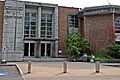
Kitsap County Courthouse
-
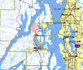
Map of Kitsap County and surrounding area
-
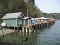
Beach cottages in Fragaria along Colvos Passage in Kitsap County
See also
 In Spanish: Condado de Kitsap para niños
