Modoc County, California facts for kids
Quick facts for kids
Modoc County, California
|
||
|---|---|---|
| County of Modoc | ||
|
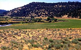
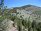
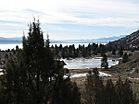
From top down, left to right: Pit River Valley, Eagle Peak, Fandango Pass overlooking Surprise Valley
|
||
|
||
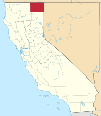
Location in the U.S. state of California
|
||
| Country | ||
| State | ||
| Region | Shasta Cascade | |
| Incorporated | February 17, 1874 | |
| Named for | the Modoc people | |
| County seat | Alturas | |
| Largest city | Alturas | |
| Government | ||
| • Type | Council–CEO | |
| Area | ||
| • Total | 4,203 sq mi (10,890 km2) | |
| • Land | 3,918 sq mi (10,150 km2) | |
| • Water | 286 sq mi (740 km2) | |
| Highest elevation | 9,892 ft (3,015 m) | |
| Population | ||
| • Total | 8,700 | |
| • Density | 2.070/sq mi (0.799/km2) | |
| GDP | ||
| • Total | $0.580 billion (2022) | |
| Time zone | UTC-8 (Pacific Time Zone) | |
| • Summer (DST) | UTC-7 (Pacific Daylight Time) | |
| Congressional district | 1st | |
Modoc County (pronounced 'mo-dok') is a county located in the far northeast corner of California. It's known for its beautiful natural areas and wide-open spaces. As of 2020, about 8,700 people live here, making it one of California's least populated counties.
The main town and county seat is Alturas. Modoc County shares borders with Nevada and Oregon. A large part of the county is federal land, managed by groups like the United States Forest Service and Bureau of Land Management. These agencies play a big role in the county's economy. Modoc County's official sayings are "The last best place" and "Where the West still lives."
Contents
History of Modoc County
Early Inhabitants: Native American Tribes
Before Europeans arrived, different groups of Native Americans lived in Modoc County for thousands of years. The county is named after the Modoc people, who lived near Lost River and Tule Lake.
Other tribes in the area included the Achomawi (also called Pit River Indians) and the Paiute. To the north, in what is now Oregon, lived the Klamath.
First European Explorers
The first European explorers to visit Modoc County were John C. Frémont and his group in 1846. They traveled from Sutter's Fort, which was near where Sacramento is today.
Modoc War and Its Impact
As more settlers arrived, there were conflicts between them and the Native American tribes. In 1864, the Klamath, Modoc, and Yahooskin tribes signed a treaty. This treaty gave up their lands in Oregon and California, and the tribes were moved to the Klamath Reservation.
However, a group of Modoc people, led by Captain Jack, returned to their homeland near Tule Lake in California. This led to the Modoc War (also called the Lava Beds War) in 1872-1873.
The Modoc warriors used the strong natural defenses of the lava tubes to hold off many U.S. Army forces. Peace talks failed, and some Modoc warriors killed peace commissioners. More Army troops were called in. Eventually, most of the Modoc were captured. Those responsible for the killings were tried and executed. Over 150 Modoc people were sent away as prisoners of war. Today, this area is known as the Lava Beds National Monument.
Forming Modoc County
Settlers began arriving in Modoc County in the 1870s, drawn by timber, gold, farming, and the railroad. The area was a key stopping point on the Lassen Applegate Trail. This trail brought settlers from Nevada to the Oregon Trail and also led south into California's central valley.
Modoc County was officially formed on February 17, 1874. Residents of the Surprise Valley wanted a new county created from the eastern part of Siskiyou County. They considered naming it after General Canby, but chose "Modoc" instead.
The town of Dorris Bridge became the county seat in 1874 and was renamed Alturas in 1876. Alturas means "The Heights" in Spanish. It officially became a city on September 16, 1901.
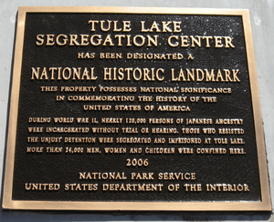
Tule Lake Segregation Center
During World War II, the U.S. government created a large camp near Newell. This was the Tule Lake War Relocation Center. It was a place where thousands of Japanese-American citizens were temporarily held. They lost many of their businesses and homes in coastal areas.
A historical marker now stands at the site along California State Route 139 in Newell. Tule Lake was the largest of these "segregation camps." In 2008, President George W. Bush made it part of the new World War II Valor in the Pacific National Monument, which is now the Tule Lake National Monument.
Geography and Natural Features
Modoc County's Unique Landscape
Modoc County covers about 4,203 square miles. Most of this is land (3,918 square miles), with 286 square miles of water. It has a very low population density, with only about 2.25 people per square mile. Modoc County is one of the few counties in California that is almost perfectly rectangular in shape.
The geology of Modoc County is quite special. Its past has been shaped by many earthquakes and volcanoes. This has created rich soil with many minerals, which is different from the usual clay-heavy soil found in the American West.
Volcanoes and Lava Formations
To the northwest of the county is Medicine Lake. This is the largest shield volcano on the U.S. West Coast. Nearby is the Lava Beds National Monument, famous for its lava tube caves. In the southwestern part of the county, you can find the huge Glass Mountain, another ancient lava flow.
The southwestern area of the county has a unique mix of oak trees and volcanic mountains, with river valleys in between.
Modoc Plateau and Wildlife
The northern half of Modoc County is mainly the Modoc Plateau. This is a high area, about 1 mile (1.6 km) above sea level. It's covered with lava flows, cinder cones, juniper trees, pine forests, and seasonal lakes like the salty Goose Lake.
Nearly 1 million acres of the Modoc National Forest are located on this plateau. It stretches between Medicine Lake to the west and the Warner Mountains to the east.
Modoc County has a wide variety of plants. Many native trees grow here, including Garry oak and Washoe pine. Jeffrey and ponderosa pines also grow in large groups. This rich plant life supports many animals. You can find mule deer, Rocky Mountain elk, and pronghorn. There are also several herds of wild horses.
The Clear Lake National Wildlife Refuge and Long Bell State Game Refuge are also on the plateau. The Lost River flows through the northern part of the plateau. Rivers in the south either collect in reservoirs or flow into the Big Sage Reservoir, which then flows into the Pit River.
Pit River and Warner Mountains
In the far southwest, below the plateau, are Big Valley and Warm Springs Valley. These form the start of the Pit River watershed. The Pit River's northern and southern branches meet just south of Alturas. The river collects water from hundreds of small creeks as it flows south to Shasta Lake. From there, it joins the Sacramento River and eventually reaches San Francisco Bay.
The eastern side of the county is dominated by the Warner Mountains. The Pit River actually starts in this mountain range. Many alpine lakes are found in these mountains, filled by snowmelt and natural springs. East of the Warner Range is Surprise Valley, which is part of the Great Basin.
Modoc County is also known for its hot springs and lava caves. There's a chance for geothermal energy here, which uses heat from the Earth.
Neighboring Counties
- Klamath County, Oregon - north
- Lake County, Oregon - north
- Washoe County, Nevada - east
- Lassen County - south
- Shasta County - southwest
- Siskiyou County - west
Protected Natural Areas
Modoc County is home to several important protected natural areas:
- Clear Lake National Wildlife Refuge
- Lava Beds National Monument (part)
- Modoc National Forest (part)
- Shasta National Forest (part)
- Modoc National Wildlife Refuge (part)
- Tule Lake National Wildlife Refuge (part)
- Tule Lake Unit, World War II Valor in the Pacific National Monument (part)
Population and People
Modoc County's Population Over Time
Modoc County's population has changed over the years. In 2020, there were 8,700 people living here. This was a decrease from 9,686 people in 2010.
| Race / Ethnicity (NH = Non-Hispanic) | Pop 2000 | Pop 2010 | Pop 2020 | % 2000 | % 2010 | % 2020 |
|---|---|---|---|---|---|---|
| White alone (NH) | 7,663 | 7,649 | 6,446 | 81.10% | 78.97% | 74.09% |
| Black or African American alone (NH) | 59 | 77 | 66 | 0.62% | 0.79% | 0.76% |
| Native American or Alaska Native alone (NH) | 340 | 293 | 387 | 3.60% | 3.02% | 4.45% |
| Asian alone (NH) | 58 | 70 | 61 | 0.61% | 0.72% | 0.70% |
| Pacific Islander alone (NH) | 7 | 21 | 13 | 0.07% | 0.22% | 0.15% |
| Other Race alone (NH) | 26 | 14 | 56 | 0.28% | 0.14% | 0.64% |
| Mixed race or Multiracial (NH) | 208 | 220 | 412 | 2.20% | 2.27% | 4.74% |
| Hispanic or Latino (any race) | 1,088 | 1,342 | 1,259 | 11.51% | 13.86% | 14.47% |
| Total | 9,449 | 9,686 | 8,700 | 100.00% | 100.00% | 100.00% |
In 2000, there were 9,449 people living in Modoc County. About 29.1% of households had children under 18. The average household had 2.39 people. The median age was 42 years old.
The median income for a household in 2000 was $27,522. Modoc County has the lowest median household income of any county in California. However, housing prices have risen, partly because people from other parts of California are moving here. They find homes more affordable, and some can work from home. This can make it harder for local residents to buy homes.
Transportation in Modoc County
Main Roads and Highways
 U.S. Route 395
 State Route 139
 State Route 299
Additionally, communities in eastern Modoc County like Eagleville, Cedarville, Lake City, and Fort Bidwell are connected by Surprise Valley Road. This road runs from the southern county line to the Oregon border.
Public Transport Options
The Sage Stage offers a "dial-a-ride" service within Modoc County. This means you can call to arrange a ride. It also provides trips to Klamath Falls, Oregon and Reno, Nevada. You can also connect to and from Reno International Airport using this service.
Airports in the Area
There are small airports for general aviation near Alturas (Alturas Municipal Airport and California Pines Airport). Other airports include Cedarville Airport, Eagleville Airport, Fort Bidwell Airport, and Tulelake Municipal Airport. The closest major airport is in Reno.
Communities in Modoc County
City
- Alturas (the county seat)
Census-Designated Places (CDPs)
These are areas identified by the U.S. Census Bureau for statistical purposes.
- Adin
- California Pines
- Canby
- Cedarville
- Daphnedale Park
- Eagleville
- Fort Bidwell
- Lake City
- Likely
- Lookout
- Newell
- New Pine Creek
Other Unincorporated Places
These are towns or communities that are not officially incorporated as cities.
Community Population Ranking (2020)
This table shows the population of communities in Modoc County based on the 2020 census.
† county seat
| Rank | City/Town/etc. | Municipal type | Population (2020 Census) |
|---|---|---|---|
| 1 | † Alturas | City | 2,715 |
| 2 | California Pines | CDP | 473 |
| 3 | Cedarville | CDP | 437 |
| 4 | Newell | CDP | 301 |
| 5 | Adin | CDP | 205 |
| 6 | Canby | CDP | 183 |
| 7 | Fort Bidwell | CDP | 180 |
| 8 | Daphnedale Park | CDP | 129 |
| 9 | XL Ranch Rancheria | AIAN | 117 |
| 10 | Fort Bidwell Reservation | AIAN | 97 |
| 11 | New Pine Creek | CDP | 87 |
| 12 | Lake City | CDP | 71 |
| 13 | Lookout | CDP | 68 |
| 14 | Likely | CDP | 53 |
| 15 | Eagleville | CDP | 45 |
| 16 | Cedarville Rancheria | AIAN | 19 |
| 17 | Lookout Rancheria | AIAN | 11 |
| 18 | Alturas Indian Rancheria | AIAN | 3 |
| 19 | Likely Rancheria | AIAN | 0 |
Images for kids
See also
 In Spanish: Condado de Modoc para niños


