
Mount Diablo facts for kids
Quick facts for kids Mount Diablo |
|
|---|---|
| Cerro Alto de los Bolbones | |

West face of Mount Diablo and Hwy 24
|
|
| Highest point | |
| Elevation | 3,849 ft (1,173 m) NAVD 88 |
| Prominence | 3,109 ft (948 m) |
| Listing | California county high points 45th |
| Naming | |
| Native name | Error {{native name}}: an IETF language tag as parameter {{{1}}} is required (help) |
| Geography | |

Mount Diablo
Location in California

Mount Diablo
Location in the United States
|
|
| Parent range | Diablo Range |
| Topo map | USGS Clayton |
| Geology | |
| Age of rock | Cretaceous, Jurassic |
| Mountain type | Sedimentary |
| Climbing | |
| Easiest route | Paved road |
| Designated: | 1982 |
| Reference #: | 905 |

Mount Diablo is a famous mountain in Contra Costa County, California. It's part of the Diablo Range in the eastern San Francisco Bay Area. You can find it south of Clayton and northeast of Danville.
This mountain stands tall at about 3,849 feet (1,173 meters). It's an "upthrust" peak, meaning it was pushed up by Earth's forces. You can see it from most of the San Francisco Bay Area! Mount Diablo often looks like a double pyramid. It has other smaller peaks nearby, like North Peak, which is almost as high at 3,557 feet (1,084 meters).
The mountain is protected within Mount Diablo State Park. This park is managed by California State Parks.
Contents
- Exploring Mount Diablo's Landscape
- Mount Diablo's Rich History and Names
- Mount Diablo's Natural Wonders
- Park Facilities and Activities
- Mount Diablo's Climate
- Art, Literature, and Pop Culture Inspired by Mount Diablo
- Exciting Events at Mount Diablo
- Famous People Connected to Mount Diablo
- Legends and Folklore of Mount Diablo
- Images for kids
- See also
Exploring Mount Diablo's Landscape
You can reach the top of Mount Diablo by walking, biking, or driving. Roads like North Gate Road and South Gate Road lead to the summit.
Mount Diablo State Park: A Natural Treasure
Mount Diablo State Park covers about 20,000 acres. It was one of the first public open spaces in the area. Today, it's part of a huge network of protected lands. This network includes 38 preserves and covers over 90,000 acres! This means lots of nature is saved for everyone to enjoy.
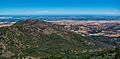
Amazing Views from the Summit
On a clear day, the views from Mount Diablo are incredible. You can often see the Sierra Nevada mountains far away. The best time for clear views is after a winter storm. Sometimes, you can even spot Lassen Peak, which is 181 miles (291 km) away!
Many bridges are visible from the top, too. These include the San Mateo, Bay, Golden Gate, Richmond–San Rafael, Carquinez, Benicia, Antioch, and Rio Vista bridges.
Mount Diablo has one of the largest "viewsheds" in the Western United States. A viewshed is the total area you can see from a certain point. Even though many mountains are taller, Mount Diablo stands out. Its height above the surrounding land makes it very noticeable. This made it a key landmark for mapping and navigation during the California Gold Rush. The summit is still used today for land surveying in much of northern California and Nevada.

Mount Diablo's Rich History and Names

Mount Diablo is a very special place for many Native American groups in California. According to their stories, it was the place where the world was created. Some stories say that the creator, Coyote, and his helper, Eagle-man, made people and the world from two islands: Mount Diablo and Reed's Peak. Another story tells of Molok the Condor bringing Wek-Wek the Falcon Hero from inside the mountain.
How Mount Diablo Got Its Name

Before Europeans arrived, about 25 different Native American groups lived around the mountain. They spoke different languages like Ohlone, Bay Miwok, and Northern Valley Yokuts. The Chochenyo-speaking Ohlone people called the mountain Tuyshtak, meaning "at the dawn of time." The Nisenan people called it Sukkú Jaman, or "dog mountain."
An early Spanish name for the mountain was Cerro Alto de los Bolbones, which means "High Hill of the Volvon." The Volvon were a Bay Miwok tribe who lived in the area.
The mountain's current name, Mount Diablo, comes from an event in 1805. Some Native Americans escaped from the Spanish in a thicket (a dense group of trees). One story says mysterious lights helped their escape. Another report from 1850 by General Mariano Guadalupe Vallejo tells of a strange dancing spirit. The natives' word for this spirit, puy, was thought to mean "devil" in English.
By 1824, the area north of the mountain was called Monte del Diablo, meaning "devil's thicket." Later, American settlers thought "Monte" referred to the mountain itself. So, "Mount Diablo" became the official name in 1850.
Attempts to Change the Name

Over the years, there have been attempts to change the mountain's name. In 2005, a person asked the government to rename it Mount Kawukum or Mount Yahweh, saying "Diablo" was offensive. Other ideas included Mount Miwok or Mount Ohlone, after the local tribes. Later, Mount Reagan was suggested. However, the United States Board on Geographic Names rejected these requests. They said there was no strong reason to change such a historic name.
Early Uses and Landmarks
In 1851, the south peak of Mount Diablo became a very important point for land surveys. It was the starting point for mapping large areas of California, Nevada, and Oregon.
Toll roads were built up the mountain in 1874. A hotel called the Mountain House Hotel was also built near the summit. In 1928, a bright navigation beacon, called the "Eye of Diablo," was placed on the summit. It was so powerful it could be seen for a hundred miles!
Protecting Mount Diablo's Natural Beauty

California started protecting Mount Diablo in 1931 by creating a small state park. Many improvements were made in the 1930s by the Civilian Conservation Corps. A botanist named Mary Bowerman helped a lot. Her studies of the plants on the mountain helped create the park's first map and led to its expansion. She also helped start "Save Mount Diablo" in 1971. This group works to protect the mountain from development. Thanks to their efforts, the state park and surrounding preserves now cover over 90,000 acres!
The State Park connects to other protected areas like Morgan Territory Regional Preserve and Black Diamond Mines Regional Preserve. This creates a large network of open spaces around the mountain.
Mount Diablo's Natural Wonders
How Mount Diablo Was Formed
Mount Diablo is a special place geologically, about 30 miles (48 km) east of San Francisco. The mountain was formed by the slow movement of Earth's plates. It sits between different earthquake faults and is still growing a tiny bit each year. This movement pushed up ancient rocks from the Jurassic and Cretaceous periods, which are now at the summit.
The top of the mountain is made of old volcanic rocks and sediments. These rocks were once part of islands in the ocean, formed between 90 and 190 million years ago. Over millions of years, these rocks were scraped off and added to the North American continent. This created the unique rocks you see on Mount Diablo today.

You can find gray sandstone, chert (a hard red rock), and volcanic rocks at the summit. The red chert is full of tiny fossils of sea creatures. In the western foothills, there are also large deposits of younger sandstone with seashells. These rocks are tilted sharply, forming dramatic ridges.
Long ago, people mined sand for glassmaking and coal from the areas north of the mountain. Today, you can visit these old mining sites at the Black Diamond Mines Regional Preserve.
Plants and Trees of Mount Diablo
The park is home to many different plants. You'll see oak trees, grasslands, and areas with thick chaparral shrubs. Some plants are found only on Mount Diablo, like the Mount Diablo manzanita and the Mount Diablo fairy-lantern.
It's important to know about western poison oak when hiking. It can cause an itchy rash, even when it has no leaves in winter.
At higher elevations, you'll find foothill pine trees. Knobcone pines grow in the southern part of the park. Mount Diablo is also one of the northernmost places where Coulter pine trees grow.
In 2005, the Mount Diablo buckwheat, a rare plant thought to be extinct since 1936, was found again on the mountain!
-
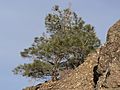
This Pinus sabiniana (foothill pine) is common in the park.


.jpg)


Wildlife: Animals of Mount Diablo
All plants, minerals, and animals in the park are protected. It's against the rules to remove anything or bother the wildlife.
You might see coyotes, bobcats, black-tailed deer, and California ground squirrels. Other mammals like mountain lions are also present. The park is a safe home for the Alameda whipsnake and the California red-legged frog, which are both threatened species.
Less common animals include peregrine falcons, ringtail cats, and American badgers. You might also spot roadrunners, California tiger salamanders, and burrowing owls. Some non-native animals like the red fox and opossum also live here.
In the fall, usually September and October, you can see male tarantula spiders (Aphonopelma iodius) looking for mates. These spiders are generally harmless. However, be careful of black widow spiders, though you're less likely to see them out in the open.
In winter, from November to February, bald eagles and golden eagles visit the mountain. The Mount Diablo area has one of the largest groups of golden eagles anywhere!
Be aware of Northern Pacific rattlesnakes. They are usually shy, but always watch where you step. They sometimes warm themselves on trails. Other things to watch out for are fleas, ticks, and mosquitoes.
If you see a mountain lion, it's important to know what to do. Stay calm, make yourself look big, and make noise. Do not run.
-
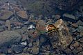
Pacific chorus frog


Park Facilities and Activities

You can enter the park from Northgate Road in Walnut Creek or Diablo Road in Danville. If the entrance stations are closed, you can pay fees at the ranger station where the two roads meet.
At the mountain's summit, there's a visitors center. It has an observation deck and exhibits about nature. The Mary Bowerman Trail is an easy, wheelchair-friendly path near the summit. It has signs that explain the area.
The park has 520 miles (837 km) of trails for hiking and horseback riding. Some trails are also open for mountain biking.
You can go camping in the park, and there are many picnic spots. Remember, pets must have proper rabies papers. Visitors must leave the park by sunset, unless there's a special event.
Alcohol is not allowed in the park. Fires are only permitted during the wet season (December to April) and only in special fire pits. The park might close on windy days in the dry season because of fire danger.
There are also entrances for hikers at Mitchell Canyon and Donner Canyon. These areas offer access to other peaks and trails, including the popular Falls Trail with seasonal waterfalls.
Mount Diablo's Climate

A weather station near Mount Diablo's summit records the weather. July is usually the warmest month, with highs around 85°F (29.5°C). January is the coolest, with highs around 55°F (13.1°C). Temperatures can reach 90°F (32.2°C) about 36 days a year.
The park gets about 24 inches (61 cm) of rain each year. Snowfall is rare at the lower parts of the mountain, averaging about 1.2 inches (3 cm) per year. However, the higher parts of the mountain get more snow. For example, in December 2009, the mountain received a rare 18 inches (46 cm) of snow in one day!
Art, Literature, and Pop Culture Inspired by Mount Diablo
_-_Google_Art_Project.jpg)
Mount Diablo has been a muse for many artists and writers. Its beauty and history have inspired paintings, books, and poems. Many artists who paint outdoors, called "plein air" painters, have captured the mountain's views. Famous photographers like Ansel Adams have also taken pictures of Mount Diablo.
The mountain has even inspired music, from the Kronos Quartet to pieces by the California Symphony. The pop-punk band The Story So Far has a song called "Mt. Diablo."
The name "Diablo" from the mountain also inspired the "Devils" in the name of the Blue Devils Drum and Bugle Corps. This group is a world champion marching band based in Concord, California.
Interestingly, the video game series Diablo got its name from Mount Diablo. The game's creator, David Brevik, lived nearby and was inspired by the mountain.
In Marvel Comics, a powerful being called Tiamut was imprisoned under the Diablo Mountain Range.
Exciting Events at Mount Diablo

Every fall, usually in September and October, male tarantulas come out of their burrows to find mates. The Mount Diablo Interpretive Association offers guided hikes to see this "March of the Tarantulas."
Since 1964, survivors of Pearl Harbor and their families have honored Pearl Harbor Day. They do this by relighting the historic beacon at the summit of Mount Diablo on December 7th.
Watching the sunset from Mount Diablo is amazing. Even more interesting is seeing the mountain's shadow stretch across the California Central Valley and then appear as a shadow in the sky after the sun goes down.
Save Mount Diablo hosts many events throughout the year. These include "Spring on Diablo" and "Autumn on Diablo" hikes. They also have special events like "Moonlight on the Mountain" and "Four Days Diablo," a long trip on the Diablo Trail.
Mount Diablo Challenge Bicycle Race
|
Mount Diablo
|
|
|---|---|

A cyclist riding up Mount Diablo
|
|
| Gain in altitude | 3,249 ft (990 m) |
| Length of climb | 10.8 mi (17.4 km) |
| Maximum elevation | 3,849 m (12,628 ft) |
| Average gradient | 5.7 % |
| Maximum gradient | 13 % |
The Mount Diablo Challenge is a popular bicycle race held every year in October. It helps raise money for Save Mount Diablo's efforts to protect the land. The race starts at the Athenian School and climbs 3,249 feet (990 meters) over 10.8 miles (17.4 km).
Hundreds of cyclists, from beginners to professionals, take part. A special "One-Hour" T-shirt is given to those who finish the climb in less than an hour. The fastest time recorded for the race is 43 minutes, 33 seconds, set by Nate English in 2008. The fastest woman's time is 48 minutes, 13 seconds, set by Flavia Oliveira in 2012.
Famous People Connected to Mount Diablo
James "Grizzly" Adams, a famous bear hunter, often visited and lived on Mount Diablo in the 1850s.
Robert Walter "Bob" Jones, the first professional baseball player from Contra Costa County, was born near the mountain in 1889.
Jazz pianist Dave Brubeck grew up on a ranch near the park's North Gate entrance.
A large part of the Blackhawk Farm, which included the mountain's southern hills, was later added to Mount Diablo State Park. The rest became the community of Blackhawk.
Legends and Folklore of Mount Diablo
Mount Diablo has many stories about strange events. People have reported seeing mysterious lights and even "phantom black panthers" on its slopes. In 1806, General Mariano Guadalupe Vallejo reported seeing a strange flying spirit during a military operation. These stories are part of why the mountain got its name, "Diablo," meaning "devil."
Images for kids
-
View of Mount Diablo's North Peak from the main peak
-
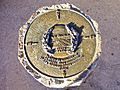
Mount Diablo Memorial Marker inside summit visitor center


See also
 In Spanish: Monte Diablo para niños
