
Argyll facts for kids
Quick facts for kids ArgyllEarra-Ghàidheal (Scottish Gaelic) |
|
| Argyllshire locator map.svg | |
| Geography | |
| Chapman code | ARL |
| History | |
| Origin | Local Government (Scotland) Act 1889 |
| Created | 1889 |
| Abolished | 1973 |
| Succeeded by | (Breifly Strathclyde (1975-1996)); Argyll and Bute |

Argyll (pronounced "ar-GYLE"), also known as Argyllshire, is a historic area in western Scotland. Its name in Scottish Gaelic is Earra-Ghàidheal. It is a beautiful region with mountains, lochs (lakes), and many islands.
Argyll has a very old history. It was once part of the ancient kingdom of Dál Riata. This kingdom also included parts of what is now Ireland. Argyll was also an important religious center in the Middle Ages. Later, it became an earldom and then a dukedom. The Duke of Argyll title was created in 1701.
Argyll shares borders with Inverness-shire to the north. To the east, it borders Perthshire and Dunbartonshire. Across the Firth of Clyde, it is close to Renfrewshire and Ayrshire. It also borders Buteshire to the south.
From 1890 to 1975, Argyll was an administrative county. Its main town was historically Inveraray. However, the county council was based in Lochgilphead. Today, most of historic Argyll is part of the Argyll and Bute council area. Some parts, like Morvern and Ardnamurchan, are now in the Highland council area.
Contents
What Does the Name Argyll Mean?
The name Argyll comes from an old Irish phrase, airer Goídel. This means "border region of the Gaels." The Gaels were an ancient group of people.
Some people also translate airer as "coast." So, the name can also mean "coast of the Gaels." This makes sense because Argyll has a long coastline.
A Look at Argyll's History
Argyll has a rich history, going back thousands of years. Many important events happened here.
Ancient Times and Early Kingdoms
The Kilmartin Glen area has standing stones and other ancient sites. These date back to about 3000 BC. This makes it one of the most important places for Neolithic (New Stone Age) and Bronze Age remains in mainland Scotland.
In 563 AD, Iona Abbey was founded. This abbey became a very important early Christian site in Scotland.

The Gaelic kingdom of Dál Riata existed from the 5th to the 9th centuries. It covered parts of Ireland and western Scotland. A fort at Dunadd in Kilmartin Glen was the main center of this kingdom.
In the 9th century, Dál Riata broke apart during the Viking Age. The Scottish part joined with the Pictish kingdom in 843 AD. This formed the Kingdom of Alba, which later became Scotland.
The name Argyll, meaning "coast or borderland of the Gaels," was then used for the mainland part of Dál Riata. This helped tell it apart from the "islands of the foreigners" (the Innse Gall), which were ruled by Vikings.
Changes in Control and Shires
Argyll was divided into several smaller areas called lordships or provinces. These included Kintyre, Knapdale, Lorn, and Cowal. There was also a smaller "Argyll proper" area around Inveraray.
Over time, Scotland lost control of some parts of Argyll to Norwegian rule. This was agreed in a treaty in 1098. However, in 1266, the Treaty of Perth brought these areas back under Scottish control. They became part of the semi-independent Lordship of the Isles.
Scotland was divided into "shires" (like counties) run by sheriffs. In 1293, two new shires were created in Argyll: Sheriff of Kintyre and Sheriff of Lorn. The first mention of a Sheriff of Argyll was in 1326. This job later became a family position held by members of Clan Campbell.
The Reformation and Clan Power
The Scottish Reformation brought big changes to Scotland's religion. The MacDonalds, who were the former Lords of the Isles, supported the old religious ways. The Campbells, however, strongly supported the new reforms.
In the early 1600s, the Campbells were sent to the islands of Islay and Jura. They took control of these islands and added them to the shire of Argyll. The Campbells also moved the sheriff court for Tarbertshire to Inveraray. This helped them gain more power. In 1633, Tarbertshire was officially joined with the shire of Argyll. Inveraray became the main town for the larger shire.
.jpg)
In 1667, "Commissioners of Supply" were set up for each shire. These groups managed the local area until county councils were created in 1890.
After the Jacobite risings in 1746, a new law changed how local government worked. The job of sheriff could no longer be passed down in families. Local government in Scotland became more like that in the rest of Great Britain. The word "county" started to be used instead of "shire."
Modern Local Government
In 1890, elected county councils were created. This changed how Argyll was governed. The Small Isles of Muck, Rùm, Canna, and Sanday were moved from Argyll to Inverness-shire in 1891.
Argyll stopped being a county for local government in 1975. Its area was split between the Highland and Strathclyde Regions. A new area called Argyll and Bute was formed. This included most of Argyll and the nearby Isle of Bute.
In 1996, a new unitary council area of Argyll and Bute was created. It still exists today. The old historic county borders of Argyll are still used for some land records.
Argyll's County Council Headquarters

The first meeting of Argyll County Council was in Inveraray in 1890. They spent a long time deciding where to meet next! They chose to meet in Dunoon in summer and Oban in winter.
The council also decided to have its main offices in Lochgilphead. They bought the old Argyll Hotel in 1925 and turned it into their offices. Even then, some departments were in other towns like Campbeltown and Oban.
After the county council was abolished in 1975, the building in Lochgilphead became a regional office. The new Argyll and Bute District Council set up its main office at nearby Kilmory Castle.
Exploring Argyll's Geography
Argyll is a very scenic area. It has two main parts on the mainland and many islands. The mainland has tall mountains and many lochs (lakes). The coastline is very jagged, with lots of sea inlets. The islands have different types of scenery, from flat to very mountainous.
Northern Mainland Argyll
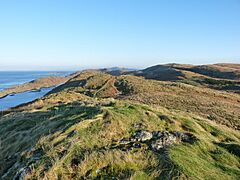
This part has two large peninsulas: Ardnamurchan and Morvern. They are separated by Loch Sunart. There's also a large inland area called Ardgour. This area is bordered by Loch Linnhe to the east.
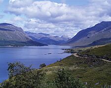
Ardnamurchan is a wild, mountainous area. It has only one main road. Ardnamurchan Point is the westernmost point of mainland Britain! Morvern is also remote and mountainous. There are many lochs in northern Argyll.
-
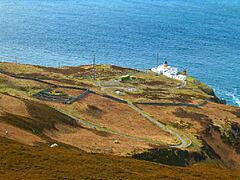
Corrachadh Mòr seen from the Ardnamurchan Point lighthouse
-
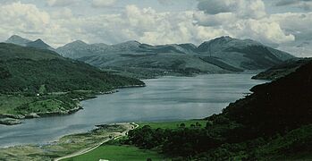
Loch Sunart
-
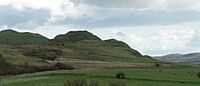
Creach Bheinn on the Morvern peninsula
-
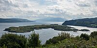
The isle of Risga
-
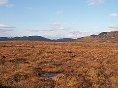
Kentra Moss flatlands


Southern Mainland Argyll
This section is much larger. It includes the long Kintyre peninsula. The Mull of Kintyre at its tip is only about 13 miles (21 km) from Northern Ireland. The coast here is very complex, with many sea inlets and smaller peninsulas.
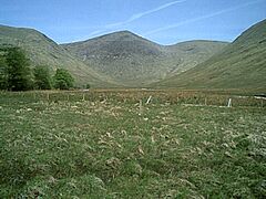
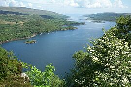
Loch Fyne separates Kintyre from the Cowal peninsula. The land in southern Argyll is generally very mountainous. There are also many lochs. Near Glen Coe is Bidean nam Bian, the tallest peak in Argyll at 1,150 meters (3,770 feet).
-
Knapdale scenery
-
Mull of Kintyre lighthouse
-
Loch Riddon
-
Loch Etive looking northeast
-
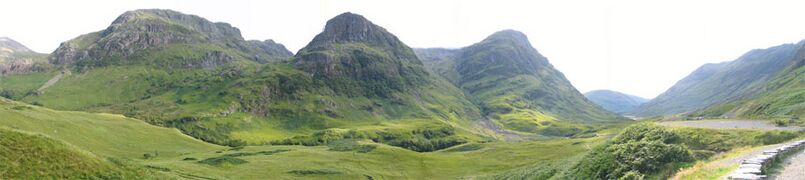
Glen Coe, with the Three Sisters of Bidean nam Bian
-
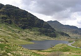
Loch Restil
-
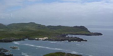
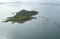
Davaar island


The Inner Hebrides Islands
Argyll includes most of the Inner Hebrides islands. Famous islands like Skye and Eigg are not part of Argyll. The islands are very different from each other. Some are flat, like Coll and Tiree. Others are very mountainous, like Jura and Mull.

-
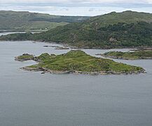
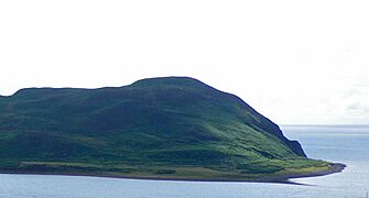
Calve Island
-
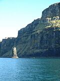
Cliffs at Iorcail on Canna
-
Cara
-
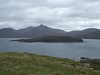
Eorsa from Mull
-
Iona Abbey
-
Dun Nosebridge on Islay
-
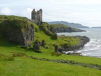
Gylen Castle on Kerrera
-
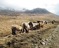
Ponies on Rum
-
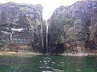
Coastal waterfall on Rum
-
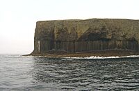
Basalt columns on Staffa
-
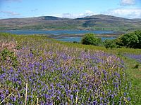
Bluebell field on Ulva


Getting Around Argyll: Transport
.jpg)
The West Highland Line railway runs through the northern part of Argyll. It stops at places like Locheilside and Banavie. A branch of this line also goes to Oban.
Many ferries connect the Inner Hebrides islands to each other and to the Scottish mainland. Many islands also have small airports. This allows people to travel by air. There is also a bus network that links the larger towns. Buses are also available on islands like Islay, Jura, and Mull.
Argyll has several small airports. These serve the region and connect to cities like Edinburgh and Glasgow. Some of these airports are Oban, Tiree, and Campbeltown.
Who Lives in Argyll? Notable Residents and Clans
Argyll is home to many historic Scottish clans. It has also been home to several famous people.
Historic Clans
- Clan Campbell was the most powerful clan in this region. The Campbells held the title of Duke of Argyll.
- Clan MacIntyre had lands here and were close to Clan Campbell.
- Clan Gregor once owned a lot of land in Argyll. They had a power struggle with the Campbells.
- Clan Lamont sometimes allied with and sometimes fought against Clan Campbell.
- Clan McCorquodale held lands around Loch Awe for a long time.
- Clan MacMillan held lands in Knapdale.
- Clan Malcolm (also known as MacCallum) has its seat at Duntrune Castle.
- Clan MacLean held lands on the Isle of Mull. Their seat was Duart Castle.
- Clan MacLachlan held lands on both sides of Loch Fyne. Their seat was in Strathlachlan.
- Clan MacEwan were cousins of the MacLachlans and also had lands in Kilfinan.
Other Famous People from Argyll
- George Orwell, the famous writer, lived on the island of Jura for a few years. He wrote his famous book Nineteen Eighty-Four there.
- Karen Matheson, a folk singer, grew up in Taynuilt.
- Frances Shand Kydd, the mother of Princess Diana, lived on the Island of Seil.
- Mike Lindup, a musician from the band Level 42, is also connected to Argyll.
Argyll in Stories and Films
Argyll's beautiful scenery and rich history have inspired many stories.
- Rosemary Sutcliff's novel The Mark of the Horse Lord is set in ancient Argyll. It tells a story of conflict and royal succession.
- A scene from the 1963 James Bond film From Russia with Love was filmed in the highlands above Lochgilphead.
- The song "The Queen of Argyll" is about a beautiful woman from the region.
- The Scottish movie Restless Natives (1985) filmed a chase scene near Lochgoilhead.
- In the TV show Downton Abbey, the housekeeper Elsie Carson is from Argyll.
- In the Harry Potter universe, a map of Argyllshire is found in Hogwarts. It mentions the Hebrides as the home of the Hebridean dragon.
Images for kids
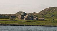
-
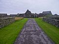
Oronsay Priory, Oronsay, Inner Hebrides

See also
 In Spanish: Argyll para niños
