
Euclid Creek facts for kids
Quick facts for kids Euclid Creek |
|
|---|---|

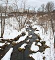
Euclid Creek near Euclid, Ohio
|
|

Location of the mouth of Euclid Creek in Ohio
|
|
| Country | United States |
| State | Ohio |
| County | Cuyahoga County |
| Physical characteristics | |
| Main source | Near 26611 Fairmount Blvd., Beachwood, Ohio 1,083 ft (330 m) 41°29′14.1894″N 81°29′25.4322″W / 41.487274833°N 81.490397833°W |
| River mouth | Lake Erie Cuyahoga County, Ohio 581 ft (177 m) 41°35′13.1778″N 81°33′55.443″W / 41.586993833°N 81.56540083°W |
| Length | 46.5 mi (74.8 km) |
| Basin features | |
| Basin size | 23 sq mi (60 km2) |
Euclid Creek is a stream that flows for about 43-mile (69 km) in Cuyahoga and Lake counties in Ohio, United States. The main part of the creek is about 11.5-mile (18.5 km) long. It starts in the Euclid Creek Reservation, which is part of the Cleveland Metroparks, and flows into Lake Erie.
The creek has two main branches. The west branch is often seen as part of the main creek. It adds another 16 miles (26 km) and reaches its starting point in Beachwood, Ohio. The east branch is 19 miles (31 km) long and begins in Willoughby Hills, Ohio.
Euclid Creek flows over very old rock layers that have been important for science. These rocks were also used for building in the Cleveland, Ohio, area in the 1800s. Today, the creek faces challenges because it runs through many cities. Parts of the creek have been changed by human activity, like being put into underground pipes or straightened. In the past, the creek was very polluted. While pollution has gotten better, the fish living in the creek are still affected. The growth of towns along Euclid Creek is a big part of Cleveland's history. Some large shopping areas built in the last 60 years have also impacted the creek.
Contents
- Where is Euclid Creek and How Does it Flow?
- Euclid Creek's Watershed
- Pollution in Euclid Creek
- Fish and Other Animals in Euclid Creek
- Plants and Wildlife in Euclid Creek
- History of Euclid Creek
- Native Americans and Euclid Creek
- Early White Settlement Around Euclid Creek
- Euclid Creek from 1812 to 1850
- Euclid Creek from 1851 to 1881
- Euclid Creek from 1881 to 1916
- Euclid Creek from 1917 to 1928
- Euclid Creek from 1928 to 1945
- Euclid Creek from 1945 to 1970
- Euclid Creek from 1970 to 1995
- Euclid Creek from 1995 to 1999
- Euclid Creek in the 21st Century
- Images for kids
Where is Euclid Creek and How Does it Flow?
Euclid Creek starts in Cuyahoga County, Ohio. It flows through Cuyahoga County and a small part of Lake County. Finally, it empties into Lake Erie. Euclid Creek is one of about 100 streams that flow directly into the lake. It is one of the largest smaller streams that feed into Lake Erie.
The stream has a main branch, an east branch, and many smaller streams that flow into them. The main branch and west branch are usually considered one long main branch. This main branch is about 16 miles (26 km) long upstream from where the two branches meet. It drains an area of about 8.5 square miles (22 km2). The east branch is 19 miles (31 km) long and drains an area of about 12.5 square miles (32 km2). Together, the main and east branches are about 46.5 miles (74.8 km) long. Their combined watershed (the area of land where all the water drains into the creek) is about 24 square miles (62 km2). More than 100 small streams make up the very beginning of Euclid Creek.
The Euclid Creek watershed is a very developed area along the Lake Erie coast in Ohio. It includes 11 cities, with 10 of them in Cuyahoga County. Around 68,000 people live in this area.
Euclid Creek has a steep average slope of about 55 feet per mile (10.4 m/km), or 1.04 percent. This is quite steep for a stream. The slope changes along the creek. Near its start, it's about 37 feet per mile (7.0 m/km). In the Euclid Reservation Metropark, it gets steeper, reaching 58 feet per mile (11.0 m/km). Near its mouth, where the lake water has flooded the creek's end (called a lacustuary), the slope is very gentle, only 0.1 feet per mile (1.9 cm/km).
What is the Geology Beneath Euclid Creek?

Euclid Creek flows over bedrock that is more than 360 million years old. These ancient rocks include the Chagrin Shale (365 million years old), the Cleveland Shale (360 million years old), and the Berea Sandstone (360 million years old). The Berea Sandstone is very hard and resists being worn away by water. This is why the tallest waterfalls on Euclid Creek are found where the stream has cut down to this rock layer.
The land's shape is created by three main areas: The Allegheny Plateau, the Portage Escarpment, and the Erie Plain. The creek's headwaters (where it starts) are on the Allegheny Plateau. The streams then drop down the steep slopes of the Portage Escarpment. Finally, they reach the flat Erie Plain before flowing into Lake Erie. The last ice age, called the Wisconsin glaciation, shaped this land. It left behind rounded hills, flat areas, and low spots that became wetlands. It also left glacial till (rock and dirt left by glaciers) and large boulders across the land.
What Fossils Can You Find?
The Chagrin Shale rock layer, which Euclid Creek exposes, contains many different arthropod fossils. These include ancient shellfish like Camarotoechia and Lingula. A new species of lobe-finned fish, called Chagrinia enodis, was discovered in the Chagrin Shale along Euclid Creek in 1960.
The Cleveland Shale along Euclid Creek also has some fossils. You might find fragments of plants and shellfish like Lingula. Fish teeth, scales, and sometimes bones or armor are the most common fossils found here. In 2008, scientists identified 65 different types of ancient fish, including sharks and armored fish.
The Bedford Shale, exposed by Euclid Creek, often has many fossils in its lowest parts. These include shellfish like Lingula and Syringothyris bedfordensis, as well as mollusks (like clams) and ancient fish from the Devonian period.
The Main Branch of Euclid Creek

The main branch of Euclid Creek starts in Beachwood, Ohio, or slightly north in Lyndhurst, Ohio. Both starting points are high up, around 1,200 feet (370 m) above sea level. The soil in this area can be poorly drained.
The main branch flows gently through cities like Lyndhurst, Mayfield Heights, Richmond Heights, South Euclid, and Euclid. After dropping down the Portage Escarpment, the stream flows across the flat Erie Plain. Much of the main branch's path was shaped by the last ice age.
This part of the creek flows through very developed areas. There isn't much floodplain (flat land next to the creek that floods) or natural stream banks left. Because much of the soil doesn't absorb water well, and there are many impervious surfaces (like roads and buildings), the creek often has sudden, fast flows like flash floods. These fast flows make it hard for fish and aquatic insects to live there.
Where it drops over the Portage Escarpment, the main branch has carved a 2.75-mile (4.43 km) long gorge. This gorge is 100 feet (30 m) to 180 feet (55 m) deep and about 600 feet (180 m) wide. Euclid Creek winds across the flat bottom of the gorge, carving a channel 10 feet (3.0 m) deep into the soil and shale rock. While the creek is usually shallow here, it has carved some deep potholes (up to 8 feet (2.4 m) deep) in the shale streambed.
After leaving the gorge, the creek flows across the Erie Plain, a flatter area. Here, it has carved a channel 200 feet (61 m) wide and 40 feet (12 m) deep. The mouth of Euclid Creek is on Lake Erie, about 570 feet (170 m) above sea level.
The East Branch of Euclid Creek
The east branch of Euclid Creek starts near Interstate 271 in Willoughby Hills, Ohio. Its starting elevation is about 860.5 feet (262.3 m) above sea level. This branch joins the main branch in the Euclid Creek Reservation. The elevation at this meeting point is about 651.9 feet (198.7 m).
From its start, the east branch mostly flows in a deep valley. While the stream banks are mostly natural, many of the smaller streams that flow into the east branch have been changed. They have been put into pipes, straightened, and have lost their natural floodplains due to city development.
Euclid Creek's Watershed

The Euclid Creek watershed is special because it has almost no farmland. More than 80 percent of the land is already developed with buildings and roads. The remaining undeveloped land is expected to be built up in the next few decades. This will add more pressure on the water quality of Euclid Creek. The Cuyahoga County Airport is the largest landowner in the watershed. Six small streams that feed the east branch flow through or near the airport's 640 acres (2.6 km2) area.
About 557.8 acres (2.257 km2) of Euclid Creek's watershed is protected land. This includes the Lower Euclid Creek Reservation and the Euclid Creek Reservation, which together are 554 acres (2.24 km2). These parks are very popular and often get crowded on weekends. This can lead to soil damage, litter, and illegal dumping. Other protected areas include conservation easements (legal agreements to protect land) over the creek's headwaters and a ravine.
Not many wetlands (areas where the land is covered by water or saturated with water) are left in the Euclid Creek watershed. Some notable wetlands are near Highland Heights Community Park and in parts of the east branch's floodplain.
Smaller Areas within the Watershed
The Euclid Creek watershed is divided into seven smaller areas, called subwatersheds:
- Subwatershed 1: Erie Plains in Nottingham—This area has 3 miles (4.8 km) of the main branch. About 6 percent is undeveloped, and over 25 percent is covered by hard surfaces like parking lots. The Lake Erie coastline and the creek's mouth have been changed a lot for beaches, marinas, and parks. The creek here is often straightened and runs in concrete channels to control floods. Unfortunately, a lot of trash and sediment builds up in this part of the creek.
- Subwatershed 2: Euclid Creek Reservation—This area has 6.8 miles (10.9 km) of the main branch and smaller streams within the Euclid Creek Reservation. About 20 percent is undeveloped, and 11 to 15 percent has hard surfaces. This part of the watershed is mostly natural, in a deep valley. Some illegal dumping happens here, and water quality is affected by polluted water running off from nearby homes after heavy rains.
- Subwatershed 3: Lower East Branch—This area has 7.8 miles (12.6 km) of the east branch and four smaller streams. About 23 percent is undeveloped, and 11 to 25 percent has hard surfaces. The creek flows through a deep valley here, which has helped protect it from major changes. However, there is some water pollution from illegal dumping, septic system overflows, and runoff from hard surfaces. A small dam and pond block the east branch here.

- Subwatershed 4: Upper East Branch—This area has 6.3 miles (10.1 km) of the east branch and four smaller streams. About 17 percent is undeveloped, and 11 to 25 percent has hard surfaces. Even though some parts of the streams have been changed, some still have their natural channels and floodplains.
- Subwatershed 5: Upper East Branch/Chagrin Plateau—This area has 5.3 miles (8.5 km) of the east branch. About 25 percent is undeveloped, and 10 to 20 percent has hard surfaces. The east branch starts here, just west of Interstate 271, and is often straightened, sometimes even flowing in a concrete streambed.
- Subwatershed 6: Highlands—This area has 3.1 miles (5.0 km) of the main branch. Only about 3 percent is undeveloped, and over 25 percent has hard surfaces. A large unnamed stream flows into the main branch here. Most of this stream has been buried in tunnels or straightened.
- Subwatershed 7: Headwaters—This area has 6 miles (9.7 km) of the main branch. About 7 percent is undeveloped, and 10 to 25 percent has hard surfaces. This area has many homes. The creek is often reinforced with wire cages filled with rocks (called gabions) in residential areas. However, it stays natural as it flows through a private golf course and the Acacia Reservation. The very beginning of the creek here is heavily changed by human construction.
Dams and Obstructions in the Creek
As of 2017, there were five dams on Euclid Creek. None of these dams produce electricity or control floods. They all block the movement of fish and other aquatic life, which is important for the creek's health. The dams are:
- St. Clair Spillway—This 9-to-10-foot (2.7 to 3.0 m) high concrete spillway stops fish from moving upstream and has harmed the habitat around it.
- David Myers Parkway Dam—This 3-to-4-foot (0.91 to 1.22 m) high concrete dam helps slow down the stream's flow.
- Mayfair Dam—This dam creates the 4-acre (0.016 km2) Mayfair Lake. The lake has a lot of algae and sediment buildup.
- Dumbarton Blvd. Dam—This 12-to-14-foot (3.7 to 4.3 m) high stone dam was built in the 1800s. It used to create a large reservoir, but now only a small pond remains because it's filled with silt.
- White Road Dam—This dam blocks about 600 feet (180 m) of a small stream that flows into the east branch.
The Euclid Creek Reservation Dam, an 8-foot (2.4 m) high dam, was removed in December 2010. This dam used to slow down the east branch, but its removal helps the creek flow more naturally.
There are also about 10 small ponds or basins in the watershed that help control stormwater overflow. Many of these are filling up with sediment.
Culverts and Channelization
About 10.4 miles (16.7 km) (24.18 percent) of Euclid Creek flows through underground pipes or tunnels. This includes parts of the main branch and the east branch.
About 4.7 miles (7.6 km) (10.9 percent) of Euclid Creek has been "channelized." This means its banks have been reinforced with concrete, or the channel has been made deeper or straighter. Channelization is meant to prevent flooding during normal rains. However, by making the stream narrower, it also makes the water flow faster. This harms fish and aquatic insect habitats and can make erosion and flooding worse during very heavy rains. A study in 2003 found that 16 miles (26 km) of Euclid Creek had moderate to high erosion because of channelization.
Pollution in Euclid Creek
How Pollution Affects the Creek
As early as 1922, scientists knew that Euclid Creek was "badly contaminated" by raw sewage.
In the 1970s and 1980s, there were many violations of water quality laws. By 2005, most illegal industrial pollution and sewage plant discharges were stopped. However, pollution control has been difficult. A 1986 study found that the water quality in Euclid Creek was poor. The stream had very high levels of harmful bacteria (like fecal coliform), and metals like iron and lead. The area near the creek's mouth was also in poor condition, with high levels of ammonia, copper, and zinc.
In 1989, a major pollution event killed many fish in the creek. Officials worried there were no fish left. Even in 1991, a sewage treatment plant was still releasing waste into Euclid Creek. However, by 2000, levels of fecal coliform had dropped in the main and east branches to meet water quality standards. Levels of phosphorus have also been reduced.
As of 2005, Euclid Creek still had pollution problems. These included too much organic matter, high levels of nutrients, and high levels of disease-causing bacteria. The main sources of pollution were combined sewer overflows during heavy rains, pollution from many different sources (like runoff from streets), septic tank overflows, and polluted stormwater.
The creek continues to have problems with disease-causing bacteria. In 2007, the creek failed fecal coliform standards 42 percent of the time. In 2008, it failed 59 percent of the time, making it one of the most polluted swimming spots in the nation. By 2011, it was called the most polluted stream in the Greater Cleveland area. It still received many sewage overflows each summer, though the number has decreased.
Controlling Pollution
Several groups and governments are responsible for controlling pollution in Euclid Creek. The Northeast Ohio Regional Sewer District manages the sewerage in most of the watershed. The Cuyahoga Soil and Water Conservation District leads conservation efforts for the stream. Various county agencies also work on water quality and development. The Ohio Coastal Management Program helps protect the part of Lake Erie where Euclid Creek flows in.
The Ohio Environmental Protection Agency (Ohio EPA) has given different parts of Euclid Creek special classifications. This means they have different rules to protect them. Most of Euclid Creek is classified as "Primary Contact Recreation Water," meaning it should be safe for people to swim in.
Fish and Other Animals in Euclid Creek

For a long time, Lake Erie and its streams had many healthy fish. Euclid Creek was no different. In the late 1800s, you could regularly catch catfish, crappies, largemouth bass, suckers, and sunfish in Euclid Creek. Sometimes, even a lake sturgeon would be found. By 1918, carp were very common, and you could still find some bass.
Pollution and other problems caused a big drop in the number and types of fish by the 1960s. A 1964 study found that only a few types of invertebrates (animals without backbones) like crayfish and mayflies remained. The only game fish left were the hogsucker, green sunfish, and white sucker. While Coho salmon and rainbow trout were seen entering the creek, they weren't able to lay eggs there. Only small, pollution-tolerant fish like the central stoneroller and common creek chub remained.

By 1984, pollution in Euclid Creek had gotten worse. Water quality was poor everywhere. Worms and midges made up most of the animals found. At one testing site, only a few fish were present, and many were sick or dead. The east branch had more types of fish than the main branch, but it was still much less diverse than other nearby creeks. All the animals in the creek were stressed by pollution.
By the late 1900s, only sucker fish survived in Euclid Creek, and they disappeared by 2000.
Today, fish populations in Euclid Creek are still affected. There aren't many different types of fish, and most are species that can tolerate pollution. Large predatory fish are missing from the creek, which is a sign of an unhealthy stream. Above the St. Clair Spillway, you mostly find pollution-tolerant minnows. Below the spillway, you might find coho salmon, rainbow trout, and smallmouth bass. Improving the areas near the shore and at the creek's mouth is important for increasing fish diversity.
Other small animals without backbones (macroinvertebrates) are doing better than the fish. Their diversity and numbers meet water quality standards in the lower part of the watershed. However, in the upper watershed, pollution-tolerant species like midges and worms are still dominant, with fewer caddisflies, mayflies, and stoneflies.
Plants and Wildlife in Euclid Creek

Even though no full wildlife survey of Euclid Creek has been done, people have seen animals typical of urban areas with green spaces. These include beavers, great blue herons, minks, red foxes, white-tailed deer, wild turkeys, and a small number of coyotes. While no endangered or threatened animals are known to live in the Euclid Creek watershed, more studies are needed to be sure.
Only a few small areas have been studied to identify plants in the Euclid Creek watershed. One endangered plant and two uncommon plants are known to exist there. Solidago puberula (downy goldenrod), a plant listed as endangered in Ohio, has its only known stable population in Ohio in Highland Heights Community Park near the east branch of Euclid Creek. Two other uncommon plants, Hypericum gentianoides (orangegrass) and Rhynchospora capitellata (brownish beaksedge), are also found in wet areas of Highland Heights Community Park. This is the only known place in Cuyahoga County for these two species.
Because Euclid Creek has been changed a lot by human activity, it is heavily affected by many invasive plant species. Phragmites australis (a type of grass) is very common, especially where the stream banks have been disturbed. Other common invasive species include garlic mustard, Japanese knotweed, autumn olive, buckthorn, and purple loosestrife.
History of Euclid Creek
Native Americans and Euclid Creek
The first people settled in northeast Ohio about 11,000 years ago, at the end of the last ice age. These early people were nomadic hunters. Later, other cultures developed, including the Whittlesey culture around 800 CE, who began farming. The Whittlesey people disappeared between 1600 and 1650 CE for unknown reasons. By the time the Iroquois people moved into northern Ohio in the 1650s, the area was mostly empty. Later, the Mingo, Odawa, and Wyandot people lived in northern Ohio. By 1850, few Native Americans lived in Ohio.
The Whittlesey people and those before them created clear trails along ridges that ran parallel to Lake Erie. These ridges were actually ancient beaches from times when Lake Erie's water levels were much higher. Several of these ridge trails crossed Euclid Creek. They became the main paths for early white explorers and settlers moving west into northern Ohio. Today, these old Native American trails are now Lakeshore Blvd., Euclid Avenue, and St. Clair Avenue.
Native Americans found it hard to get from the flat Erie Plain up to the steep Appalachian Plateau. Euclid Creek was one of the few natural access points. Modern Nottingham Road/Dille Road was originally a Native American trail that followed the southern edge of the Euclid Creek gorge.
Early White Settlement Around Euclid Creek
White settlers began building log cabins near Euclid Creek in 1795. The area around Euclid Creek was surveyed in 1796, and Euclid Township was created. The surveyors, who were good at math, named the township after the Greek mathematician Euclid. In October 1796, a survey team named the large creek they found between Doan Brook and the Chagrin River "Euclid Creek."
In 1797, another survey team marked two main routes through the area: North Highway (now St. Clair Avenue) and Central Highway (now Euclid Avenue). North Highway was renamed St. Clair Road in 1815.
The first permanent white settler, Joseph Burke, arrived in 1798. David Dille arrived later that year, settling southwest of Euclid Creek. William Coleman settled at the mouth of Euclid Creek in 1803 or 1804. Other settlers followed, clearing land and building homes.
Central Highway, also known as Buffalo Road, became the main route through the area. It connected what is now Cleveland to Buffalo, New York. By 1815, it was a dirt road, and a stagecoach began running daily. The road was renamed Euclid Avenue in 1825.
Travelers on Buffalo Road often needed help crossing Euclid Creek and its deep gorge. Wagons had to be unloaded, and cargo carried across by hand. Some wagons even had to be taken apart. The Hermle family set up a smithy and wheelwright shop nearby to help. An inn, Euclid House, was built at the crossing in 1815.
In 1810, Abraham Bishop built a sawmill on his land on the east branch of Euclid Creek.
The War of 1812 marked the end of the first period of white settlement in Ohio. During the war, American soldiers were stationed at the mouth of Euclid Creek to watch for British ships. In 1813, a British naval force anchored off Euclid Creek during a storm. Sailors came ashore and took a farmer's ox for food, apologizing for it.
Euclid Creek from 1812 to 1850
After the War of 1812, a small village called Euclid Creek formed at the intersection of what is now Euclid Avenue and Highland Road. The villagers built a blockhouse for protection. In 1816, Abraham Farr opened a tavern there. A Methodist church was built in 1821, and a Baptist church from 1821 to 1822. By 1840, the village had three stores, and a post office was added in 1849.
Other important businesses opened along Euclid Creek. Around 1815, Paul Condit opened a tavern. In 1817 or 1818, William Coleman built a gristmill (for grinding grain) and later a sawmill near the mouth of Euclid Creek. His neighbor, William Gray, started a stoneware factory around 1820. This factory grew quickly.
In the late 1810s, the Welch family bought land in the Euclid Creek gorge. This area became known as Welch's Woods and is now part of the Euclid Creek Reservation.
A large number of people settled in Euclid Township in 1836 and 1837, starting many new farms and businesses. In 1837, a city was planned at the mouth of Euclid Creek, but it was never built. In 1840, James Hendershot and Harvey Hussong each opened a stone quarry on Euclid Creek. Madison Sherman also opened a quarry and a mill for cutting stone. Around 1840, a shipyard opened on the east side of the creek's mouth, building canal boats. The shipyard moved in 1845 and started building schooners before closing in 1850.
Euclid Creek from 1851 to 1881

A major change for Euclid Creek happened in 1851 when the Cleveland, Painesville and Ashtabula Railroad (CP&A) built a bridge over the creek at St. Clair Avenue. This stone arch bridge was wide enough for both trains and wagons. The railroad also built a water and fuel stop called Euclid Depot next to the creek.
The railroad caused road traffic to shift from Euclid Avenue to St. Clair Avenue, and the population center moved with it. The area around Euclid Depot grew so fast that in 1860, a Catholic parish was established there. By 1865, Euclid Depot had become a large village, renamed Nottingham by the railroad.
Euclid Cemetery opened in 1864 just south of Euclid Avenue. It was created to combine over 80 small burial grounds.
In 1863 or 1864, attorney George Gilbert opened Camp Gilbert, the Cleveland area's first resort, on the west bank of the creek's mouth. It had a large brick building, a clubhouse, and fishing areas. Gilbert sold the camp in 1874 to the Ursuline nuns, who started Villa Angela, a boarding school for girls, in 1878. A boys' boarding school, St. Joseph Seminary, opened there in 1886.
After the Civil War, grape growing and winemaking began in the Euclid Creek floodplain. Vineyards appeared in the Euclid Creek gorge. More quarries opened in the gorge after the war. Duncan McFarland opened a large commercial stone quarry in 1867. His sons opened another quarry in 1871. The Forest City Stone Company also opened a quarry in 1871, and later bought the McFarland quarries. These quarries operated until 1915.
Euclid Creek from 1881 to 1916

In October 1882, the New York, Chicago and St. Louis Railroad (nicknamed the "Nickel Plate") opened. This railroad passed through the Village of Euclid Creek, making it an important stop again. The railway built a bridge over Euclid Creek.
In 1895, the city of Cleveland began paving Euclid Avenue, making it a modern street. A new stone arch bridge was built in 1902 to carry Euclid Avenue over Euclid Creek.
Swedish immigrants built a Lutheran church on the banks of Euclid Creek in 1898.
Henry Pickands, a wealthy businessman, bought 25 acres (0.10 km2) of land above Euclid Creek in 1902. In 1903, he finished building a large brick mansion called Chestnut Hills. His widow had it torn down in 1938 and a new home built.

In 1907, a masonry bridge was built for Lakeshore Blvd. over Euclid Creek. In 1908, a larger concrete bridge was built for St. Clair Avenue over the creek.
The first major development south of the Euclid Creek gorge happened in 1909. The Mayfield Country Club was founded in Lyndhurst. They bought land and dammed Euclid Creek to provide water for their new golf course. The club opened in 1911.
A new church was built by Nottingham Congregational Church on the west bank of Euclid Creek in 1910.
The first of three bridges for Highland Road over Euclid Creek was built in 1912. Before this, cars used shallow crossings (called fords) to get over the creek at these points.
Central High School was built on the east bank of Euclid Creek in 1913. It was later rebuilt as Central Middle School.
Important changes also began to happen at the creek's headwaters. In 1913, Charles K. Arter built Arter House, a large mansion, on the east bank of the main branch in Lyndhurst. His children later donated the estate to the Sisters of Notre Dame de Namur, who turned it into the Julie Billiart School. In 1916, Chester C. Bolton and his wife, Frances, established the Franchester Place estate. In 1922, the Hawken Boys' School built a new school on the east bank of the main branch, next to the Julie Billiart School.
Euclid Creek from 1917 to 1928
The Cleveland Metropolitan Park District (now Cleveland Metroparks) was created in 1917. They started buying land along Euclid Creek to create the Euclid Creek Reservation. By 1926, they had bought over a mile of the creek south of Euclid Avenue. By 1930, Cleveland Metroparks controlled what is now the Euclid Creek Reservation.
The Cleveland Metroparks made few improvements to the Euclid Creek gorge at first. In 1933, the federal government approved a Civilian Conservation Corps (CCC) camp in the Euclid Creek Reservation. Over the next three years, CCC workers cleared land, planted trees, and built picnic areas, trails, and parking lots. They also built three bridges for Highland Road, removing the last fords, and built what is now Metro Park Drive. Workers also reinforced and straightened parts of the creek. The Euclid Creek Reservation officially opened on June 24, 1936, as the first public park in the Cleveland Metroparks system.
Other green spaces were also developed. The Harms family sold their remaining vineyard land to the Sisters of the Good Shepherd in 1920, who built Our Lady of Lourdes Shrine there. In 1921, Dudley S. Blossom and his wife, Elizabeth, bought an estate and built a large home. Elizabeth Blossom created a wild garden in the small valley where Euclid Creek flowed on their estate.
Another development that affected the headwaters of Euclid Creek was the Acacia Country Club, which opened in 1923. The club drained water into Euclid Creek using many miles of pipes.
Euclid Creek from 1928 to 1945
Fast development on the Appalachian Plateau began to affect both branches of Euclid Creek after 1920.
In 1928, the Curtiss-Wright corporation bought land and opened Herrick Field, a dirt-runway airport. It closed in 1930 due to noise complaints. Cuyahoga County bought the airfield in 1946, and it reopened in 1950. The airport expanded over the years, affecting several small streams that feed the east branch.
The 1902 bridge over Euclid Creek was rebuilt in 1932.
A part of Claribel Creek, a small stream that flows into Euclid Creek, was straightened in 1933 when Ohio Villa, a country club, opened. The club later became the Richmond Country Club in 1942, and Mayfair Dam was built that year to create Mayfair Lake.
In 1942, the Sisters of St. Joseph of St. Mark bought the Pickands estate. The mansion was turned into the Mount St. Joseph Nursing Home.
Euclid Creek from 1945 to 1970
The city of Cleveland began building the Nottingham Intake and Filtration Plant on Euclid Creek in 1947. This plant was designed to provide fresh water from Lake Erie to the city's growing east side. It finally opened in 1951.
While the water plant was being built, the Cuyahoga County Airport opened in May 1950.
In 1954, a bridge was approved to link Monticello Blvd. and Wilson Mills Road over Euclid Creek. The large, $1.2 million structure opened in December 1955.
Construction of Interstate 271 began in 1960. The freeway crossed two small streams of the east branch, and these waters were redirected into a man-made ditch. The completion of Interstate 271 led to a building boom on the east side of Cuyahoga County, greatly affecting Euclid Creek's headwaters.
Construction of Interstate 90 through Euclid began in 1961. Euclid Creek was straightened, and a large interchange was built. Beneath the freeway, Euclid Creek was put into an underground pipe and a concrete channel was built to replace the natural streambed. This project changed how communities treated water, leading to more streams being buried in tunnels or pipes.
The headwaters of Redstone Run, a major stream of the east branch, were affected by construction in 1962. A shopping mall (now Richmond Town Square) was built, and the company agreed to spend money to put the headwaters of Redstone Run into pipes and reroute them. The mall opened in September 1966.
In 1966, a new development in Beachwood impacted the headwaters of the main branch of Euclid Creek. The Jewish Orthodox Home for the Aged (now Menorah Park Jewish Home for the Aged) moved to a large new site. Over the next 50 years, Menorah Park built a large senior living campus, further affecting the creek's headwaters.
Euclid Creek from 1970 to 1995
Villa Angela completed a new school building in 1972 on its property at the mouth of Euclid Creek. The old school building was torn down.
In 1976, the Rouse Co. announced plans to build a shopping mall, Beachwood Place, on land that included part of the headwaters of the main branch of Euclid Creek. Construction began in 1977, and much of the creek's channel was changed. Beachwood Place opened in 1978.
In 1981, after years of flooding, the United States Army Corps of Engineers worked to reduce erosion and flooding on Euclid Creek. The old Lakeshore Blvd. bridge was replaced with a wider one. The city of Cleveland bought land along the stream, removed old bank reinforcements, and straightened and deepened parts of the creek. They also built a levee (a raised bank) along the east side of the creek.
Minor changes to the Euclid Creek lacustuary happened in 1985 when land was bought from Villa Angela to expand Euclid Beach. In 1987, plans began to buy the Villa Angela lands and turn them into a public park.
Major changes came to the Euclid Creek lacustuary when Villa Angela closed in 1989. Land was purchased by The Trust for Public Land and then by the Ohio Department of Natural Resources (ODNR) for parkland. ODNR also spent money to stabilize Euclid Creek's banks and straighten a tributary. The Cleveland Public Library (CPL) bought land from Villa Angela to build a new branch library. The library system agreed to keep part of its land as parkland. The new Nottingham-Memorial Branch Library opened in 1994.
In 1991, Montefiore Home, a nursing home, opened next to Menorah Park in Beachwood, further impacting the headwaters of the main branch of Euclid Creek. The facility has expanded several times since then.
The 1932 bridge over Euclid Creek was repaired in 1991. The bridge carrying Anderson Road also had significant repairs.
ODNR built a road and parking lots in the new park at the mouth of Euclid Creek in 1993 and 1994. A new bridge was built over the creek's mouth. More improvements were added in 1994, including a new beach, a biking/hiking path, boat docks, and a fishing pier. The park was combined with the Cleveland Lakefront State Park. The creek mouth was dredged (cleaned out) when the pier was finished.
Euclid Creek from 1995 to 1999
The widening of Interstate 271, completed in 1993, led to new flooding problems on Euclid Creek. The Ohio Department of Transportation (ODOT) had not built new flood control measures. Studies found that the widening project and too much development in Beachwood had caused more water to run off into Euclid Creek. Beachwood had also allowed construction in the floodplain that didn't follow federal rules.
In 1997, a study blamed the widening of I-271 and overdevelopment in Beachwood for worse erosion in the Euclid Creek Reservation and flooding downstream. Stormwater velocity and volume had increased significantly. A 1999 study found that Beachwood had not followed standard stormwater management practices.
In response to flooding and sewer problems, the Northeast Ohio Regional Sewer District (NEORSD) started a large project in 2001. The first part was the Euclid Creek Storage Tunnel, a large underground tunnel designed to store stormwater. This tunnel was completed in 2015 and became operational in 2016.
Also in 2001, Cleveland and nine suburbs formed the Euclid Creek Watershed Council. This group works together on flooding and water quality issues. They planned to restore the creek's natural curves (meanders) as an initial goal.
Euclid Creek in the 21st Century
In 2002, a new group called the Euclid Creek Watershed Council formed to address flooding and water quality. They work with the Euclid Creek Watershed Coordinator, who helps manage the creek and its watershed.
The headwaters of the main branch of Euclid Creek were greatly affected by the construction of the Legacy Village shopping center in Lyndhurst in 2003. TRW Inc. had owned the land and decided to sell it. Lyndhurst voters approved changing the zoning to allow retail. TRW donated most of the old Bolton estate to the Cleveland Clinic and sold the rest to a real estate company.
Legacy Village opened on October 24, 2003. Some of the land was kept as a buffer, and 25 acres (100,000 m2) of woodlands and wetlands were saved and restored. The Cuyahoga Soil and Water Conservation District was given a conservation easement to protect a small stream.
Removing dams on Euclid Creek became a priority in the mid-2000s. A 2005 study suggested that removing the St. Clair Spillway would greatly improve fish populations. The Euclid Creek Reservation Dam was removed in 2010 after a five-year effort.
Despite improvements, flash flood-like runoff remained a problem for Euclid Creek by 2010. The Euclid Creek Reservation was heavily damaged by these fast flows.
Cleveland Metroparks bought the Acacia Country Club in 2012 and began restoring Euclid Creek within the new park. The club's owners agreed to sell the land to The Conservation Fund, which then donated it to Cleveland Metroparks. One of the first projects was to restore Euclid Creek by removing pipes, rebuilding a winding channel, and reconnecting the stream to its floodplain. This work was paid for with grants and was called the "single largest restoration effort in the history of the watershed."
A pedestrian-only bridge was built over the mouth of Euclid Creek by Cleveland Metroparks in 2016. The old fishing pier was torn down in 2016, and a new one was built in 2017.
NEORSD began a project in November 2017 to remove gravel, sand, wood, and trash from Euclid Creek's man-made channel. This helps improve habitat and water flow.
Images for kids
-
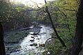
Euclid Creek near Euclid, Ohio
-
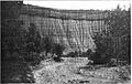
Euclid Creek near the intersection of Metropark Blvd. and Highland Road in 1913. The creek has exposed about 70 feet (21 m) of the Chagrin Shale, topped by about 5 feet (1.5 m) of the Cleveland Shale.
-
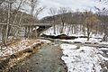
Confluence of the main branch (left) and east branch of Euclid Creek in the Euclid Creek Reservation
-
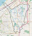
Euclid Creek watershed
-
Near the headwaters of Euclid Creek at 1 David Myers Parkway in Beachwood, Ohio
-
Nonbiting midges are one of the most common invertebrate species remaining on Euclid Creek in the 21st century.
-
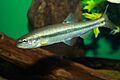
The common creek chub is one of the few pollution-tolerant fish species to be found in Euclid Creek.
-
Phragmites australis, a grass that is one of the most common invasive species along Euclid Creek
-
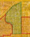
1858 map of Euclid Township.
-
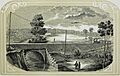
1854 engraving depicting the Cleveland, Painesville & Ashtabula Railroad bridge over Euclid Creek.
-
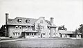
Chestnut Hills, the mansion built above Euclid Creek by Henry Pickands in 1903
-

The Lakeshore Blvd. bridge over Euclid Creek in 1909

