Geography of Alabama facts for kids
The geography of Alabama describes the land and natural features of this state in the Southeastern United States. Alabama is a diverse place, with everything from tall mountains to flat valleys and sandy beaches along the coast. It is the 30th largest state in the U.S. Alabama shares its borders with four other states: Mississippi, Tennessee, Georgia, and Florida. It also has a coastline along the Gulf of Mexico.
Contents
Amazing Land Features
Alabama has several different land regions, each with its own unique look.
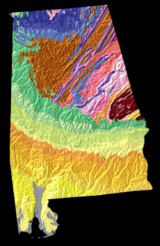
The Cumberland Plateau
In the northern part of Alabama, you'll find the Cumberland Plateau. This area is also known as the Tennessee Valley region. It stretches across the state's northern border. Here, the land forms wide, flat areas called tablelands, which are cut through by rivers. Some parts of this plateau are high and flat, about 700 to 800 feet (213 to 244 meters) above sea level. South of these high areas, near the Tennessee River, the land is gently rolling and lower, between 500 and 800 feet (152 to 244 meters) high. To the northeast, the land gets rougher, with steep mountainsides and deep, narrow valleys. Elevations here can range from 400 to 1,800 feet (122 to 549 meters). A special feature in the southern part of this region is Little Mountain, which stretches about 80 miles (129 km) from east to west. It rises sharply about 500 feet (152 meters) above the valleys next to it.
The Appalachian Valley
Next to the Cumberland Plateau, to the southeast, is the Appalachian Valley region. People in Alabama often call it the Coosa Valley. This area is the very southern end of the famous Appalachian Mountains. It covers about 8,000 square miles (20,720 square km) in the state. This region is mostly made of limestone, with strong, parallel rock ridges that stand tall like mountains because softer rocks around them have worn away. The mountains and valleys generally run from northeast to southwest. In the northeast, you'll see flat-topped mountains like Raccoon and Lookout, which are over 1,800 feet (549 meters) high near the Georgia border. As you go southwest, they get lower.
The Piedmont Plateau
Southeast of the Appalachian Valley is the Piedmont Plateau. This area also comes into Alabama from the northeast. It's a smaller, triangular-shaped section. Its surface is gently rolling, about 1,000 feet (305 meters) above sea level. The Piedmont Plateau was once a higher area that got worn down by water and wind. Then, it was lifted up again to form a plateau.
The Coastal Plain
The rest of Alabama is covered by the Coastal Plain. In the middle of the state, this area has rolling hills and prairies, with an average height of about 600 feet (183 meters). As you move southwest, it gets lower and flatter. In the very south, it's almost flat and only a little bit above sea level, right by the ocean.
Alabama's Rivers
The Tennessee River and its smaller rivers drain the Cumberland Plateau region, flowing to the west-northwest. All other parts of Alabama drain to the southwest. The Coosa River is the main river in the Appalachian Valley. In the Piedmont Plateau, you'll find the Tallapoosa River. The Coastal Plain has several important rivers: the Tombigbee River in the west, and the Alabama River in the central-west. The Alabama River is formed when the Coosa and Tallapoosa rivers join together. In the east, the Chattahoochee River forms almost half of Alabama's border with Georgia. The Tombigbee and Alabama rivers meet near the southwest corner of the state. Their waters flow into Mobile Bay through the Mobile and Tensas rivers. The Black Warrior River is another big river that flows into the Tombigbee from the east.
The valleys in northern Alabama are usually deep and narrow. But in the Coastal Plain, they are wide and often have three levels of terraces rising above the river. Mobile Bay was formed when the lower parts of the Alabama and Tombigbee river valleys sank, allowing the sea to flood them.
Plants and Animals
Alabama is home to many different plants and animals, similar to other states along the Gulf Coast. The Mobile River system is especially rich in unique freshwater snails and clams, showing a high level of biodiversity.
Forests and Trees
Vast forests of pine trees cover a large part of Alabama. You can also find many other trees like cypress, hickory, oak, populus, and eastern redcedar. In some northern areas, there are hemlock trees, and in the southwest, southern white cedar. Other native trees include ash, hackberry, and holly. Near the Gulf Coast, you'll see different kinds of palmetto and palm trees. Alabama also has over 150 types of shrubs, including mountain laurel and rhododendron. Beautiful cultivated plants like wisteria and camellia also grow here.
Wildlife
In the past, Alabama had many large mammals like plains bison, eastern elk, North American cougar, and bear. Today, only the white-tailed deer is still very common. Animals you might still see include the bobcat, American beaver, muskrat, raccoon, Virginia opossum, rabbit, squirrel, red and gray foxes, and long-tailed weasel. Animals like the coypu and nine-banded armadillo were brought to the state and are now common.
Alabama's birds include majestic golden and bald eagles, osprey, and other hawks. You might also spot yellow-shafted flickers and black-and-white warblers. Popular game birds are bobwhite quail, duck, wild turkey, and goose. Freshwater fish like bream, shad, bass, and sucker are common in rivers and lakes. Along the Gulf Coast, you can find fish like tarpon, pompano, red drum, and bonito at different times of the year.
The U.S. Fish and Wildlife Service lists 99 animals, fish, and birds, and 18 plant species in Alabama as endangered. This means they are at risk of disappearing forever. Some of these endangered animals include the Alabama beach mouse, gray bat, Alabama red-bellied turtle, fin and humpback whales, bald eagle, and wood stork.
Alabama has several official state symbols that represent its unique nature. These include the American black bear, racking horse, yellow-shafted flicker, wild turkey, Atlantic tarpon, largemouth bass, southern longleaf pine, eastern tiger swallowtail, monarch butterfly, Alabama red-bellied turtle, Red Hills salamander, camellia, oak-leaf hydrangea, peach, pecan, and blackberry.
Climate and Soil
Alabama has a humid subtropical climate. This means it has hot, humid summers and mild winters.
Temperatures
The summer heat in the south is made a bit cooler by winds coming from the Gulf of Mexico. In the north, the higher elevation helps to cool things down. The average yearly temperature is highest along the coast in the southwest and lowest in the highlands of the northeast. For example, in Mobile, the average yearly temperature is about 67°F (19°C). In the summer, it averages 81°F (27°C), and in winter, it's around 52°F (11°C). In contrast, at Valley Head in De Kalb county, the average yearly temperature is 59°F (15°C), with summer averaging 75°F (24°C) and winter 41°F (5°C). In Montgomery, in the central part of the state, the average yearly temperature is 66°F (19°C). The average winter temperature is 49°F (9°C), and summer is 81°F (27°C). On average, the temperature drops below freezing (32°F or 0°C) about 35 days each year. Very rarely, the temperature can fall below 0°F (-18°C), like during a very cold wave in February 1899, when it reached -17°F (-27°C) in Valley Head. The hottest temperature ever recorded in Alabama was 109°F (43°C) in Talladega county in 1902.
Rainfall and Storms
The most rain falls along the coast, about 62 inches (1,574 mm) each year. The rest of the state gets about 52 inches (1,320 mm) of rain, spread fairly evenly throughout the year. Snow usually falls once a winter in the south and twice in the north. However, the snow melts quickly, and sometimes the ground isn't covered with snow at all during an entire winter. Heavy snow can happen, though, like during the New Year's Eve snowstorm in 1963 or the big storm in 1993. Hailstorms sometimes happen in spring and summer, but they usually don't cause much damage. Thick fog is rare and mostly happens along the coast. Thunderstorms occur all year. They are most common in summer but can be strongest in spring and fall. During these times, strong winds and tornadoes can sometimes occur. Hurricanes are quite common in Alabama, especially in the southern part. Major hurricanes can hit the coast and cause a lot of damage.
Soil Types
Alabama's soil can be divided into four main regions.
- Timber Belt: This area stretches about 150 miles (241 km) north from the Gulf Coast. Its soil is sandy and not very rich, but it improves well with fertilizer.
- Black Prairie (Cotton Belt): North of the Timber Belt is the inner part of the Coastal Plain, also called the Black Prairie. This region covers about 13,000 square miles (33,670 square km) and includes seventeen counties. It gets its name from its black soil, which comes from weathered limestone. This soil has very little sand or loam but is rich in limestone and marl. It's perfect for growing cotton, which is why it's also called the Cotton Belt.
- Mineral Region (Old Land): Between the Cotton Belt and the Tennessee Valley is the mineral region, or Old Land area. This area has strong, resistant rocks. The soils here come from these rocks and vary in richness. The best soils come from granite, sandstone, and limestone, while poorer soils come from other rock types.
- Cereal Belt: North of the mineral region is the Cereal Belt, which includes the Tennessee Valley and the counties beyond. The richest soils here are the red clays and dark loams found in the river valley. North of these are less fertile soils, formed from sandy and sandstone areas.
Wetumpka Meteor Crater
Wetumpka is famous for what some call "Alabama's greatest natural disaster." About 80 million years ago, a meteorite about 1,000 feet (305 meters) wide crashed into the area. The hills just east of downtown Wetumpka are actually the remains of this huge impact crater, which was about 5 miles (8 km) wide! Scientists call it the Wetumpka crater or an astrobleme, which means "star-wound," because of the circular cracks and shattered rock found underground. In 2002, a scientist named Christian Koeberl proved that this site was indeed an internationally recognized impact crater.
Public Lands to Explore
Alabama has many public lands where people can enjoy nature and outdoor activities. These include four national forests and one national preserve, which make up over 25% of the state's public recreation land.
- Alabama State Parks
- Alabama Public Fishing Lakes
- Alabama Wildlife Management Areas
- Little River Canyon National Preserve
- Russell Cave National Monument
- National Forests
- Conecuh National Forest
- Talladega National Forest
- Tuskegee National Forest
- William B. Bankhead National Forest
- Wilderness Areas
- Cheaha Wilderness
- Dugger Mountain Wilderness
- Sipsey Wilderness
- National Recreation Trail
- Pinhoti National Recreation Trail
- National Wildlife Refuge
- Bon Secour National Wildlife Refuge
- Cahaba River National Wildlife Refuge
- Choctaw National Wildlife Refuge
- Eufaula National Wildlife Refuge
- Fern Cave National Wildlife Refuge
- Key Cave National Wildlife Refuge
- Mountain Longleaf National Wildlife Refuge
- Sauta Cave National Wildlife Refuge
- Watercress Darter National Wildlife Refuge
- Wheeler National Wildlife Refuge
 | Selma Burke |
 | Pauline Powell Burns |
 | Frederick J. Brown |
 | Robert Blackburn |


