
Geography of Taiwan facts for kids

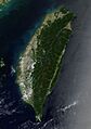
Taiwan is mostly mountainous in the east, with gently sloping plains in the west. The Penghu Islands appear in the Taiwan Strait to the west of the main island.
|
|
.svg) |
|
| Region | East Asia |
|---|---|
| Area | Ranked 138 |
| • Total | 36,197 km2 (13,976 sq mi) |
| • Land | 89.7% |
| • Water | 10.3% |
| Coastline | 1,566.3 km (973.3 mi) |
| Highest point | Yu Shan, 3,952 m (12,966 ft) |
| Climate | Tropical marine |
| Natural resources | Small deposits of coal, natural gas, limestone, marble, asbestos, arable land, rice |
| Environmental issues | Air pollution, water pollution from industrial emissions and raw sewage, contamination of drinking water, trade in endangered species, low-level radioactive waste disposal |
| Exclusive economic zone | 83,231 km2 (32,136 sq mi) |
| Taiwan | |||||||||||||||||||||||||||||||||||
|---|---|---|---|---|---|---|---|---|---|---|---|---|---|---|---|---|---|---|---|---|---|---|---|---|---|---|---|---|---|---|---|---|---|---|---|
 |
|||||||||||||||||||||||||||||||||||
| Traditional Chinese | 臺灣 or 台灣 | ||||||||||||||||||||||||||||||||||
| Simplified Chinese | 台湾 | ||||||||||||||||||||||||||||||||||
| Postal | Taiwan | ||||||||||||||||||||||||||||||||||
|
|||||||||||||||||||||||||||||||||||
Taiwan, officially called the Republic of China (ROC), is an island country in East Asia. The main island of Taiwan was once known as Formosa, which means "beautiful island" in Portuguese. This island makes up 99% of the land controlled by the ROC.
Taiwan is about 35,808 square kilometres (13,826 sq mi) in size. It lies about 180 kilometres (112 mi) away from the southeastern coast of mainland China, across the Taiwan Strait. To the north of Taiwan is the East China Sea, and to its east is the Philippine Sea. The Luzon Strait is to the south, and the South China Sea is to the southwest. The ROC also controls smaller islands like the Penghu archipelago, Kinmen, and Matsu Islands.
Geologically, Taiwan is mostly made of five rugged mountain ranges in the east. The western part has flatter plains where most people live. Yu Shan, at 3,952 m (12,966 ft), is the highest peak, making Taiwan the world's fourth-highest island. The island often experiences earthquakes because it sits on active tectonic plate boundaries. There are also many active submarine volcanoes in the Taiwan Straits.
Taiwan's climate varies from tropical in the south to subtropical in the north. It is affected by the East Asian Monsoon. On average, four typhoons hit the island each year. The eastern mountains are heavily forested and home to many different animals. The western lowlands are used a lot by people for farming and cities.
Contents
Taiwan's Location and Size
Taiwan's total land area is 36,197 km2 (13,976 sq mi), which is a bit larger than Belgium. It has a coastline that stretches for 1,566.3 km (973.3 mi). The country also claims an exclusive economic zone of 83,231 km2 (32,136 sq mi) around its shores.
The main island of Taiwan, known as Formosa in the past, is 394 km (245 mi) long and 144 km (89 mi) wide. Its area is 35,808 km2 (13,826 sq mi). The northernmost point is Cape Fugui in New Taipei. The center of the island is in Puli Township. The southernmost point is Cape Eluanbi in Hengchun Township.
Surrounding Waters
The Taiwan Strait separates the island of Taiwan from mainland China. This strait is between 130 km (81 mi) and 220 km (140 mi) wide. It is not very deep, usually less than 100 m (330 ft). During ice ages, it even became a land bridge.
To the south, the Luzon Strait separates Taiwan from the Philippine island of Luzon. This strait is 250 km (155 mi) wide. The South China Sea is to the southwest, the East China Sea to the north, and the Philippine Sea to the east.
Smaller Islands of Taiwan
Taiwan also includes several smaller islands. The Penghu islands are in the Taiwan Strait, about 50 km (31 mi) west of the main island. They cover an area of 127 km2 (49 sq mi). Other small islands include Xiaoliuqiu off the southwest coast, and Orchid Island and Green Island to the southeast. The islands of Kinmen and Matsu are very close to the coast of Fujian in mainland China. They have a total area of 180 km2 (69 sq mi).
How Taiwan Was Formed

The island of Taiwan was created about 4 to 5 million years ago. This happened at a place where two large tectonic plates meet and push against each other. These plates are the Philippine Sea Plate and the Eurasian Plate.
Along the length of the island, the Eurasian Plate is slowly sliding under the Philippine Sea Plate. This process formed the mountain ranges you see today. The western part of the island is made of rock layers scraped off the Eurasian Plate. In the northeast, the Philippine Sea Plate slides under the Eurasian Plate.
Because these plates are still moving, Taiwan experiences many earthquakes. Each year, there are between 15,000 and 18,000 earthquakes. People can feel about 800 to 1,000 of these. One of the most powerful recent earthquakes was the magnitude-7.3 Chi-Chi earthquake in 1999. It caused a lot of damage and sadly, over 2,400 people lost their lives.
Taiwan's Diverse Landscape

Taiwan's landscape has two main parts. The western third of the island has flat or gently rolling plains. This is where about 90% of the population lives. The eastern two-thirds of the island are covered by rugged, forest-covered mountains.
Mountain Ranges
The eastern part of Taiwan has five main mountain ranges. They all run roughly parallel to the east coast, from north-northeast to south-southwest. These ranges are about 330 km (210 mi) long and average about 80 kilometres (50 mi) wide. They include over two hundred peaks that are taller than 3,000 m (9,800 ft).
The Central Mountain Range runs from the northeast to the southern tip of the island. It forms a high ridge and acts as the main watershed for the island's rivers. These mountains are made of hard rock, but heavy rainfall has carved deep gorges and sharp valleys into their sides. The mountains are very rugged and dense with forests, making them hard to cross. The east side of this range is very steep, with cliffs ranging from 120 to 1,200 m (390 to 3,900 ft) high. Taroko National Park is on this steep eastern side, showing amazing gorges and erosion from fast-flowing rivers.
The East Coast Mountain Range runs along the east coast. It is mostly made of sandstone and shale. This range is separated from the Central Range by the narrow Huatung Valley. While its highest peak is 1,682 m (5,518 ft), most of this range consists of large hills.
West of the Central Range are two other groups of mountains. They are separated by the Sun Moon Lake Basin in the middle of the island. Rivers like the Dadu and Zhuoshui River flow from the Central Range's western slopes through this basin to the west coast.
The Xueshan Range is to the northwest of the Central Mountain Range. It starts at the northeast tip of the island and gets higher as it goes southwest. Xueshan, its main peak, is 3,886 m (12,749 ft) high.

The Yushan Range runs along the southwest side of the Central Range. It includes Taiwan's tallest peak, the 3,952 m (12,966 ft) Yu Shan ('Jade Mountain'). This makes Taiwan the world's fourth-highest island.
The Alishan Range is west of the Yushan Range. Its main peak, Data Mountain, is 2,663 m (8,737 ft) tall.
Western Plains and Basins
Below the western mountains are raised terraces and fertile plains. These areas were formed by material eroded from the mountains. Important plains include the Chianan Plain in southwest Taiwan, the Pingtung Plain, Taichung Basin, and Taipei Basin. The only large plain on the east coast is the Yilan Plain in the northeast. About 23% of Taiwan's land is made of these fertile plains and basins.
Taiwan's Climate

Taiwan lies across the Tropic of Cancer, which means its climate is warm. The East Asian Monsoon also strongly influences its weather. Northern Taiwan has a humid subtropical climate, meaning it has noticeable changes in temperature between seasons. Central and southern Taiwan have a tropical monsoon climate, where temperatures are warm to hot all year round.
During winter (November to March), the northeast part of the island gets steady rain. However, the central and southern parts are mostly sunny. The summer monsoon (from May to October) brings most of the yearly rain. It accounts for 90% of the rain in the south but only 60% in the north. On average, Taiwan receives about 2,600 mm of rain each year.
|
||||||||||||||||||||||||||||||||||||||||||||||||||||||||||||||||||||||||||||||||||||||||||||||||||||||||||||||||||||||||||||||||||||||||||||||||||||||||||||||||||||||||||||||||||||||||||||||||||||||||||||||||||||||||||||||||||||||||||||||||||||||||||||||||||||||||||||||||||||||||||||||||||||||||||||||||||||||||||||||||||||||||||||||||||||||||||||||||||||||||||||||||||||||||||||||||
Typhoons and Rain
Typhoons are strong storms that usually hit Taiwan between July and October. On average, about four typhoons directly hit the island each year. These storms bring very heavy rain, which often causes dangerous mudslides in the mountains.
Temperature Records
| Area | Max. temperature | Date | Earliest recording | |
|---|---|---|---|---|
| °C | °F | |||
| Taipei City | 39.3 | 102.7 | 8 August 2013 | 1896 |
| Kaohsiung City | 37.6 | 99.7 | 15 September 2014 | 1932 |
| Taitung County | 40.2 | 104.4 | 9 May 2004 | |
| Taoyuan City | 37.9 | 100.2 | 15 September 2014 | |
Plants and Animals of Taiwan
Before many people settled in Taiwan, the island had a wide variety of plants. These ranged from tropical rainforests in the lowlands to temperate forests and alpine plants higher up in the mountains.
Most of the plains and low hills in the west and north have been cleared for farming. This happened after Chinese immigrants arrived in the 17th and 18th centuries. However, the mountain forests are still very diverse. They have unique species like the Formosan cypress and Taiwan fir.

Taiwan is also a special place for birds, with many species found only there.
Before the country became industrialized, the mountainous areas were home to several unique animal species. These included the Swinhoe's pheasant, Taiwan blue magpie, and the Formosan sika deer. Some of these animals are now extinct, and many others are endangered species.
Taiwan has 65 species of fireflies, which is a very high number. They are protected, and their numbers are growing. However, climate change is a long-term threat to them.
Taiwan has relatively few carnivores, with 11 species in total. The Formosan clouded leopard is likely extinct. The otter is now only found on Kinmen island. The largest carnivore is the Formosan black bear, which is a rare and endangered species.
National Parks: Protecting Nature
Taiwan has nine national parks that protect its varied landscapes, plants, and animals.
- Kenting National Park in the south has uplifted coral reefs, tropical forests, and marine life.
- Yushan National Park features high mountains, unique mountain ecosystems, and different forest types.
- Yangmingshan National Park has volcanic areas, hot springs, and waterfalls.
- Taroko National Park is famous for its marble canyon, cliffs, and folded mountains.
- Shei-Pa National Park protects alpine ecosystems and valley streams.
- Kinmen National Park has lakes, wetlands, and coastal areas with special plants and animals.
- Dongsha Atoll National Park protects the Pratas reef atolls, which have unique marine life and are important for the South China Sea.
Natural Resources of Taiwan

Taiwan has small amounts of natural resources like gold, copper, coal, natural gas, limestone, marble, and asbestos. About 55% of the island is covered by forests and woodlands, mostly in the mountains. 24% is arable land (land that can be farmed), mainly on the plains.
Over time, many of Taiwan's natural resources have been used up. This includes minerals like coal and gold, and wild animals like deer. Much of Taiwan's forests, especially firs, were cut down in the past. Today, forests are not used much for timber because of environmental rules and high costs.
Farming and Fishing
The most important natural resources left in Taiwan are related to agriculture. Sugarcane and rice have been grown in western Taiwan since the 1600s. In the past, making camphor and refining sugar were very important for Taiwan's exports. These industries became less important when global demand for them dropped.
Farming (especially rice) and fishing are still important. However, they face challenges from imported goods since Taiwan joined the World Trade Organization in 2002. Now, Taiwan's agriculture focuses on growing special crops for sale and export. These include bananas, guavas, lychees, bell fruits, and high-mountain tea.
Energy Resources

Taiwan has a good amount of coal. It also has some small amounts of petroleum and natural gas. In 2010, oil made up 49% of Taiwan's total energy use. Coal was next at 32.1%, followed by nuclear energy at 8.3%, and natural gas at 10.2%. Renewable energy sources made up 0.5%.
Taiwan has six nuclear reactors, with two more being built. Most of the oil and gas needed for transportation and power must be imported. This makes Taiwan sensitive to changes in energy prices. Taiwan has strong wind energy resources, with wind farms both on land and offshore. The government wants to use more renewable energy to help the environment and create new industries.
People and Environment

Taiwan has over 23 million people. Most of them live in the lowlands along the western coast. The island is very urbanized, meaning many people live in cities. Nearly 9 million people live in the Taipei–Keelung–Taoyuan metropolitan area in the north. Over 2 million people live in the urban areas of Kaohsiung and Taichung.
Taiwan's People
Taiwanese indigenous peoples make up about 2% of the population. They mostly live in the mountainous eastern part of the island. Many experts believe their ancestors came to Taiwan by sea between 4000 and 3000 BC.
Han Chinese people make up over 95% of the population. Immigrants from southern Fujian started farming around modern Tainan and Kaohsiung in the 17th century. They later spread across the western and northern plains. Hakka people from eastern Guangdong arrived later and settled in the foothills. The rugged eastern mountains remained home to the indigenous peoples until the early 20th century. Another 1.2 million people from China came to Taiwan at the end of the Chinese Civil War in 1949.
Environmental Challenges

Some areas in Taiwan with many people and factories have heavy pollution. The southern suburbs of Taipei and the western area from Tainan to Lin Yuan (south of Kaohsiung) are particularly affected. In the late 20th century, Taipei had a lot of air pollution from vehicles and factories. However, the government made changes, like requiring unleaded gasoline and setting up the Environmental Protection Administration in 1987. These actions have greatly improved Taiwan's air quality.
However, motor scooters, especially older ones, are very common in Taiwan and still add to city air pollution. The Taichung Power Plant also creates a lot of air pollution.
Other environmental issues include water pollution from factories and untreated sewage. Drinking water supplies can also be affected. There is also the issue of trade in endangered species and disposing of low-level radioactive waste. Even though rules for pollution from burning oil are strict, acid rain is still a problem for people's health and forests. Scientists in Taiwan believe that more than half of the pollution causing Taiwan's acid rain comes from China, carried by monsoon winds.
In the past, Taiwan had a serious problem with illegal dumping of trash. It was even called "garbage island." This high level of pollution led to actions by both citizens and the government. By 2022, Taiwan's recycling rate was one of the highest in the world, at 55%. Community efforts and new ideas, like garbage trucks playing music, were key to this change.
Illegal sand dredging by Chinese vessels has caused significant damage to the marine environment around Taiwan's outlying areas. The Taiwan Banks are especially affected. Bottom trawling (a fishing method) is also controversial because it harms the environment. There are rules that limit how close trawlers can fish to the shore. In 2023, the highest penalty for ocean pollution was increased from US$48,820 to US$3.25 million.
Images for kids
-
Taiwan is mostly mountainous in the east, with gently sloping plains in the west. The Penghu Islands appear in the Taiwan Strait to the west of the main island.
-
Map of Taiwan
-

Taiwan
See also
 In Spanish: Geografía de Taiwán para niños
