Geography of Wisconsin facts for kids
Wisconsin is a state in the Midwestern United States. It has many different types of land, famous for shapes made by huge sheets of ice called glaciers. These glaciers moved across the land about 17,000 years ago during the Wisconsin glaciation.
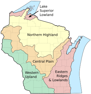
The state is split into five main areas: the Lake Superior Lowland, Northern Highland, Central Plain, Eastern Ridges & Lowlands, and Western Upland. A special part in the southwest, called the Driftless Area, was not covered by ice during the last ice age. Glaciers helped create places like the Wisconsin Dells, Devil's Lake, and the Baraboo Range. Many beautiful spots are protected, such as Devil's Lake State Park and the Apostle Islands National Lakeshore.
Wisconsin has four seasons with a humid continental climate. Summer temperatures are usually around 80°F (27°C), and winter temperatures are about 5°F (-15°C). The state is bordered by the Mississippi River, St. Croix River, and Menominee River. It also touches Lake Michigan and Lake Superior. Wisconsin is the 23rd largest state in the U.S., covering about 65,496 square miles (169,639 km2).
Contents
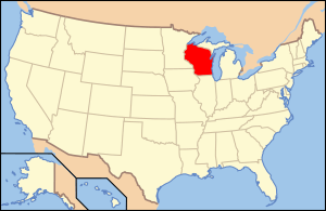
Where is Wisconsin Located?
Wisconsin is in the Midwestern United States. It is the 23rd largest state by area. About 17% of Wisconsin's total area is water. This includes parts of Lake Michigan and Lake Superior, plus many lakes inside the state.
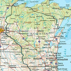
Wisconsin shares borders with Lake Superior and Michigan to the north. Lake Michigan is to the east, and Illinois is to the south. To the southwest is Iowa, and to the northwest is Minnesota. The state's western border follows the Mississippi River and St. Croix River. In the north, the Menominee River and Montreal River form parts of the border. Wisconsin is in the Central Time Zone.
The spot farthest from any state border is about 94 miles (152 km) southwest of Wausau.
Wisconsin's People and Places
In 2020, Wisconsin had 5,893,718 people. This made it the 27th state in terms of how many people live per square mile. The middle point of Wisconsin's population is in Green Lake County, near the city of Markesan.
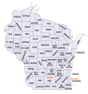
Wisconsin is divided into 72 counties. It also has 190 cities, 407 villages, and 1250 towns. Milwaukee County has the most people, with about 939,489 residents. Most of them live in the city of Milwaukee, which is the state's largest city. Madison is the state capital and is located in Dane County. Dane County is the second most populated county.
Marathon County is the largest in size, covering about 1,545 square miles (3,999 km2). This county is home to a special spot: the 45°N, 90°W point. This point is halfway between the North Pole and the Equator, and halfway between the Prime Meridian and the 180th Meridian. A metal marker shows this unique location.
Wisconsin's Climate
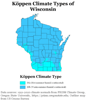
Most of Wisconsin has a climate with warm summers and cold winters. This is called a humid continental climate. The southern parts of the state have hotter summers. The highest temperature ever recorded in Wisconsin was 114°F (46°C) in the Wisconsin Dells on July 13, 1936. The lowest temperature was -55°F (-48°C) in Couderay on February 2 and 4, 1996.
Wisconsin gets about 28 to 34 inches (710 to 860 mm) of rain each year. It also gets a lot of snow. Southern areas average about 40 inches (100 cm) of snow annually. Areas near Lake Superior can get up to 160 inches (410 cm) of snow each year.
| Climate data for Wisconsin (normals 1981–2010) | |||||||||||||
|---|---|---|---|---|---|---|---|---|---|---|---|---|---|
| Month | Jan | Feb | Mar | Apr | May | Jun | Jul | Aug | Sep | Oct | Nov | Dec | Year |
| Record high °F (°C) | 66 (19) |
69 (21) |
89 (32) |
97 (36) |
109 (43) |
106 (41) |
114 (46) |
108 (42) |
104 (40) |
95 (35) |
84 (29) |
70 (21) |
114 (46) |
| Mean daily maximum °F (°C) | 23.9 (−4.5) |
29.2 (−1.6) |
40.6 (4.8) |
55.5 (13.1) |
67.3 (19.6) |
76.3 (24.6) |
80.4 (26.9) |
78.2 (25.7) |
69.8 (21.0) |
56.9 (13.8) |
41.2 (5.1) |
27.5 (−2.5) |
52.9 (11.6) |
| Daily mean °F (°C) | 15.0 (−9.4) |
19.6 (−6.9) |
30.5 (−0.8) |
44.0 (6.7) |
55.3 (12.9) |
64.7 (18.2) |
69.1 (20.6) |
67.1 (19.5) |
58.7 (14.8) |
46.5 (8.1) |
33.1 (0.6) |
19.4 (−7.0) |
43.6 (6.4) |
| Mean daily minimum °F (°C) | 3.7 (−15.7) |
6.3 (−14.3) |
18.3 (−7.6) |
31.6 (−0.2) |
42.6 (5.9) |
52.4 (11.3) |
57.2 (14.0) |
55.0 (12.8) |
47.1 (8.4) |
36.2 (2.3) |
23.7 (−4.6) |
10.6 (−11.9) |
31.8 (−0.1) |
| Record low °F (°C) | −54 (−48) |
−55 (−48) |
−48 (−44) |
−20 (−29) |
7 (−14) |
20 (−7) |
27 (−3) |
22 (−6) |
10 (−12) |
−7 (−22) |
−34 (−37) |
−52 (−47) |
−55 (−48) |
| Average precipitation inches (mm) | 1.15 (29) |
1.03 (26) |
1.80 (46) |
2.63 (67) |
3.54 (90) |
4.17 (106) |
3.79 (96) |
3.78 (96) |
3.75 (95) |
2.38 (60) |
2.00 (51) |
1.27 (32) |
31.29 (794) |
| Average snowfall inches (cm) | 11.4 (29) |
9.5 (24) |
8.7 (22) |
3.2 (8.1) |
0.4 (1.0) |
0.0 (0.0) |
0.0 (0.0) |
0.0 (0.0) |
0.0 (0.0) |
0.8 (2.0) |
4.9 (12) |
10.2 (26) |
48.7 (124) |
Wisconsin's Geographic Regions
Wisconsin is located between the Great Lakes and the Mississippi River. It has many different land features. The state is divided into five main areas: the Lake Superior Lowland, Northern Highland, Central Plain, Western Upland, and Eastern Ridges & Lowlands. These regions were named by geographer Lawrence Martin. They are different because of how glaciers shaped them during the Wisconsin glaciation.
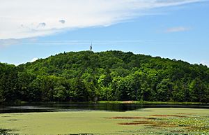
In the north, the Lake Superior Lowland is a flat area along Lake Superior. It gently slopes down towards the lake. This region has many forests with aspen and birch trees. It also includes the Apostle Islands National Lakeshore.
The Northern Highland, in north-central Wisconsin, has huge forests with mixed hardwood and pine trees. This includes the 1.5 million-acre (6,100 km2) Chequamegon-Nicolet National Forest. There are also thousands of lakes formed by glaciers. This area is generally higher than the rest of the state, with many hills. It includes Timms Hill, the highest point in Wisconsin.
In the middle of the state, the Central Plain has unique sandstone formations, like the Dells of the Wisconsin River. It also has rich farmland. This region is mostly a flat, sandy plain. Much of it was once covered by a large ancient lake called Glacial Lake Wisconsin.
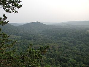
The Western Upland in the southwest is a rugged area with forests and farms. It has many tall bluffs along the Mississippi River. This region is known for its hilly land, including the Baraboo Range. The Western Upland is part of the Driftless Area. This special area also covers parts of Iowa, Illinois, and Minnesota. It was not covered by glaciers during the last ice age. Many caves in Wisconsin are here, such as the Natural Landmark Cave of the Mounds. Langlade County has a rare soil type called Antigo silt loam.
The Eastern Ridges and Lowlands region is in the southeast. Many of Wisconsin's largest cities are located here. This area is west of Lake Michigan and is mostly a plain that slopes down to the lake. The ridges include the Niagara Escarpment, the Black River Escarpment, and the Magnesian Escarpment.
Wisconsin's Geology
Wisconsin has rocks and land features that are very old, from over three billion years ago to just a few thousand years ago. Most of the rocks are millions of years old. The oldest rocks formed over 600 million years ago during the Precambrian era. Most of these are hidden under glacial deposits.
Rocks from the Proterozoic era make up many of Wisconsin's unique features. For example, much of the Baraboo Range is made of Baraboo Quartzite, which is a very old type of rock changed by heat and pressure.
During the Pleistocene Ice Age, huge glaciers covered Wisconsin. These glaciers flattened mountains, carved out bedrock, and left behind sand and gravel. The many lakes in Wisconsin were formed when glaciers carved out low spots in the land.
Several long, steep slopes called escarpments cut through Wisconsin. The Niagara Escarpment is the longest. It stretches from New York through Ontario, Michigan, Wisconsin, and Illinois. The Black River Escarpment runs close to the Niagara Escarpment. The Magnesian Escarpment is the most noticeable. The Niagara Escarpment is made of dolomite rock, while the other two ridges have limestone.
Wisconsin's Physical Geography
Rivers in Wisconsin
Wisconsin is bordered by the Mississippi River and St. Croix River to the west. The state has more than 12,000 named rivers and streams. Together, they stretch for about 84,000 miles (135,000 km).
The state gets its name from the Wisconsin River, which is 430 miles (690 km) long. Its name comes from the Algonquian languages of the Native American people. The river starts in Lac Vieux Desert near the Michigan border. It flows south through central Wisconsin's flat glacial plain. Then it turns west in Portage and joins the Mississippi River. The Baraboo River flows into the Wisconsin River. It is one of the longest free-flowing rivers in the United States.
The Fox River starts in central Wisconsin. It flows north through Lake Winnebago and into the Bay of Green Bay. The city of Green Bay is at its mouth. The two parts of the Fox River are 182 miles (293 km) long. If you include Lake Winnebago, it's about 200 miles (320 km) long. The river's name comes from a translation of the Meskwaki people's name, as the river runs through their land. Many cities along the river are part of the Fox Cities area.
Lakes in Wisconsin
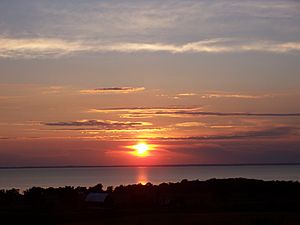
Wisconsin is bordered by Lake Superior in the north and Lake Michigan in the east. The state has over 15,000 named lakes. These lakes cover about 1 million acres (4,000 km2) of land. Lakes Superior and Michigan cover about 6.4 million acres (26,000 km2) within Wisconsin's borders. Wisconsin has over 500 miles (800 km) of shoreline along these two Great Lakes.
Lake Winnebago is the largest lake entirely within Wisconsin. It covers over 137,700 acres (557 km2) and has 88 miles (142 km) of shoreline. This lake formed from an ancient lake called Glacial Lake Oshkosh about 12,000 years ago. Devil's Lake is shaped like a rectangle. It is over a mile long from north to south and half a mile wide. Lake Wisconsin is a man-made lake on the Wisconsin River. It covers 1,500 acres (6.1 km2).
Islands in Wisconsin
Many of Wisconsin's named islands are in the Great Lakes. Many are around the Door Peninsula in Lake Michigan. Others are part of the Apostle Islands in Lake Superior. The Mississippi River also has many islands on Wisconsin's western border. Lakes and rivers inside the state have the rest of Wisconsin's islands. Lakes like Beaver Dam Lake, Fox Lake, and Lake Winnebago have many islands. Large rivers, like the Wisconsin River and Fox River, also have many islands.
Doty Island, in the Fox River, is one mile wide and one and a half miles long. French Island is in the Mississippi River, within the city of La Crosse. It covers about 2 square miles (5.2 km2) and has 4,207 people living there.
Madeline Island in Lake Superior is the largest of the Apostle Islands. The town of La Pointe is on its western shore. The island has a population of 302 people. Washington Island in Lake Michigan is about 7 miles (11 km) northeast of the Door Peninsula. The island is 5 miles (8 km) wide and 8 miles (13 km) long, covering about 23.5 square miles (60.9 km2). The town of Washington Island includes the island and nearby islands, with a total population of 708.
Wisconsin's Aquifer
The Cambrian-Ordovician Aquifer is a layer of rock underground that holds water. It is mostly shallow under Wisconsin. It also reaches into Illinois, Iowa, Indiana, Minnesota, Missouri, and the Upper Peninsula of Michigan. People are pumping water from this aquifer for farming, businesses, and homes. This use is not sustainable, meaning more water is being taken out than can be naturally refilled.
Protected Natural Areas
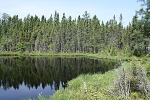
Wisconsin has 67 state parks, covering over 60,570 acres (245.1 km2). Several of these parks are well-known across the country. The Chippewa Moraine State Recreation Area covers 3,063 acres (12.4 km2). It protects many landforms created by glaciers. The Ice Age National Scenic Trail runs through this park.
Devil's Lake State Park is in the Baraboo Range, south of Baraboo. It covers 9,217 acres (37.3 km2), making it the largest state park. The park has 500-foot (150 m) high bluffs made of quartzite rock around the lake. About 11 miles (18 km) of the Ice Age Trail are also in the park.
Interstate State Park is made of two parks next to each other, on the border of Minnesota and Wisconsin. The Wisconsin side covers 1,330 acres (5.4 km2). The parks are located around the Dalles of the St. Croix River, which is a deep gorge made of basalt rock. Wyalusing State Park is where the Wisconsin River meets the Mississippi River. It covers 2,628 acres (10.6 km2).
Wisconsin also has protected areas managed by the National Park Service. The Apostle Islands National Lakeshore is along Lake Superior. It includes 21 of the Apostle Islands, covering 69,372 acres (280.7 km2). The Ice Age Trail is a National Scenic Trail that is 1,200 miles (1,900 km) long. It follows the path of the last glaciers in Wisconsin. The western end is in Interstate State Park, and the eastern end is in Potawatomi State Park, on the Door Peninsula. The trail goes through 30 of Wisconsin's 72 counties. The Saint Croix National Scenic Riverway protects 252 miles (406 km) of the St. Croix and Namekagon Rivers.
Wisconsin has several state forests, covering over 471,329 acres (1,907 km2). In total, forests cover about 16 million acres (65,000 km2), or 46%, of the state's land. The Kettle Moraine State Forest covers 56,000 acres (230 km2) in southeastern Wisconsin. Its main feature is the Kettle Moraine, which was formed by glaciers. There is one national forest managed by the U.S. Forest Service in the state, called Chequamegon-Nicolet National Forest. It was created in 1933 as two separate forests but has been managed as one since 1998.
 | John T. Biggers |
 | Thomas Blackshear |
 | Mark Bradford |
 | Beverly Buchanan |


