
Hartford County, Connecticut facts for kids
Quick facts for kids
Hartford County
|
|
|---|---|
   ,_Old_Wethersfield_Historic_District,_Connecticut.JPG)  Top-bottom, left-right: Hartford County skyline from Heublein Tower, the Hartford skyline, the New Britain skyline, a house in Old Wethersfield, and the Old State House in Hartford.
|
|

Location within the U.S. state of Connecticut
|
|
 Connecticut's location within the U.S. |
|
| Country | |
| State | |
| Founded | May 10, 1666 |
| Named for | Hertfordshire, England |
| Seat | none (since 1960), Hartford (before 1960) |
| Largest municipality | Hartford (population) Glastonbury (area) |
| Area | |
| • Total | 750 sq mi (1,900 km2) |
| • Land | 735 sq mi (1,900 km2) |
| • Water | 16 sq mi (40 km2) 2.1%% |
| Population
(2020)
|
|
| • Total | 899,498 |
| • Density | 1,199.3/sq mi (463.1/km2) |
| Time zone | UTC−5 (Eastern) |
| • Summer (DST) | UTC−4 (EDT) |
| Congressional districts | 1st, 2nd, 5th |
Hartford County is a region located in the north central part of the U.S. state of Connecticut. It is the second-most populated county in Connecticut. In 2020, about 899,498 people lived there.
Hartford County is home to the city of Hartford. Hartford is the state capital of Connecticut. It is also the most populated city in the county. Hartford County is part of a larger area called the Hartford-East Hartford-Middletown metropolitan area.
In 2022, the U.S. Census Bureau changed how it counts counties in Connecticut. Instead of the old counties, they now recognize nine "councils of governments." These groups handle some local government tasks. Connecticut's old county governments stopped working in 1960. The eight historical counties still exist in name, but they are not used for official statistics anymore.
Contents
History of Hartford County
Hartford County was one of the first four counties in Connecticut. It was created on May 10, 1666. The Connecticut General Court made a law to establish it.
The law said that towns along the river, from Windsor to Thirty Miles Island, would be one county. This county would be called Hartford County. It also said that the County Court would meet in Hartford twice a year.
When it was first created in 1666, Hartford County included five towns. These were Windsor, Wethersfield, Hartford, Farmington, and Middletown. The "Thirty Miles Island" mentioned in the law became the town of Haddam in 1668.
Over time, more towns were added to Hartford County. For example, Simsbury was created in 1670. This extended the county all the way to the Massachusetts border. Some towns later moved to other counties. For instance, Waterbury moved to New Haven County in 1728.
In 1714, all the land in northeastern Connecticut that wasn't part of a town was placed under Hartford County. Then, in 1726, Windham County was formed. This meant Hartford County lost some towns like Windham and Coventry.
Later, in 1751, Litchfield County was created. This took away the northwestern part of Connecticut from Hartford County. In 1785, two more counties, Tolland and Middlesex, were established. These changes mostly set the modern borders of Hartford County.
Small changes to the county's borders happened in the late 1700s and early 1800s. The last change was on May 8, 1806. This is when the town of Canton was established.
Geography and Landscape
Hartford County covers about 751 square miles. Most of this area, about 735 square miles, is land. The remaining 16 square miles (2.1%) is water. It is the second-largest county in Connecticut by land area.
The Connecticut River divides the county into two parts. Many other rivers and streams flow through the county. These include the Farmington, Mill, Podunk, and Scantic rivers.
The land in Hartford County is very varied. Some parts along the rivers are flat and can flood. Other areas are hilly or even mountainous.
Neighboring Counties
Hartford County shares its borders with several other counties:
- Hampden County, Massachusetts (to the north)
- Tolland County (to the east)
- New London County (to the southeast)
- Middlesex County (to the south)
- New Haven County (to the southwest)
- Litchfield County (to the west)
Communities in Hartford County
In Connecticut, counties do not have their own governments. They mainly help define areas for courts. Local services like schools, police, and fire departments are handled by each city or town. Cities and towns can also work together to provide services.
Cities in Hartford County
Towns in Hartford County
Population and People
| Historical population | |||
|---|---|---|---|
| Census | Pop. | %± | |
| 1790 | 38,149 | — | |
| 1800 | 42,147 | 10.5% | |
| 1810 | 44,733 | 6.1% | |
| 1820 | 47,264 | 5.7% | |
| 1830 | 51,131 | 8.2% | |
| 1840 | 55,629 | 8.8% | |
| 1850 | 69,967 | 25.8% | |
| 1860 | 89,962 | 28.6% | |
| 1870 | 109,007 | 21.2% | |
| 1880 | 125,382 | 15.0% | |
| 1890 | 147,180 | 17.4% | |
| 1900 | 195,480 | 32.8% | |
| 1910 | 250,182 | 28.0% | |
| 1920 | 336,027 | 34.3% | |
| 1930 | 421,097 | 25.3% | |
| 1940 | 450,189 | 6.9% | |
| 1950 | 539,661 | 19.9% | |
| 1960 | 689,555 | 27.8% | |
| 1970 | 816,737 | 18.4% | |
| 1980 | 807,766 | −1.1% | |
| 1990 | 851,783 | 5.4% | |
| 2000 | 857,183 | 0.6% | |
| 2010 | 894,014 | 4.3% | |
| 2020 | 899,498 | 0.6% | |
| U.S. Decennial Census 1790–1960 1900–1990 1990–2000 2010–2018 |
|||
What the 2010 Census Showed
In 2010, there were 894,014 people living in Hartford County. There were over 350,000 households. The population density was about 1,216 people per square mile.
Most people (72.4%) were white. About 13.3% were black, and 4.2% were Asian. People of Hispanic origin made up 15.3% of the population. Many residents had Italian, Irish, Polish, English, or German backgrounds.
About one-third of households had children under 18 living there. The average household had 2.47 people. The average family had 3.06 people. The average age of people in the county was 39.9 years old.
The average income for a household was about $62,590. For families, it was about $78,599. About 10.7% of the population lived below the poverty line.
Transportation
Major Roads
Many important highways and roads run through Hartford County. These include:
 I-91
I-91 I-84
I-84 I-291
I-291 I-384
I-384 I-691
I-691- US 5
- US 6
- US 44
 US 202
 Route 2
 Route 3
 Route 4
 Route 9
 Route 15
 Route 20
 Route 72
- Route 179
 Route 187
 Route 189
 Route 218
Public Transport Options
- Connecticut Transit Hartford provides bus services in the area.
Education
Hartford County has many school districts. These districts manage the public schools in the different towns and cities.
School Districts for All Grades (K-12)
- Avon School District
- Berlin School District
- Bloomfield School District
- Bristol School District
- Canton School District
- East Granby School District
- East Hartford School District
- East Windsor School District
- Enfield School District
- Farmington School District
- Glastonbury School District
- Granby School District
- Hartford School District
- Manchester School District
- New Britain School District
- Newington School District
- Plainville School District
- Regional School District 10
- Rocky Hill School District
- Simsbury School District
- South Windsor School District
- Southington School District
- Suffield School District
- West Hartford School District
- Wethersfield School District
- Windsor School District
- Windsor Locks School District
High School Districts
- Regional High School District 08
Elementary School Districts
- Hartland School District
- Marlborough School District
Images for kids
-

Hartford County skyline from Heublein Tower
-
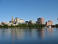
The Hartford skyline
-
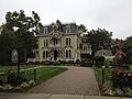
A house in Old Wethersfield
-

The Old State House in Hartford
See also

In Spanish: Condado de Hartford para niños
