Jefferson County, Ohio facts for kids
Quick facts for kids
Jefferson County
|
|||
|---|---|---|---|

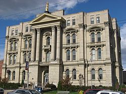
Jefferson County Courthouse
|
|||
|
|||

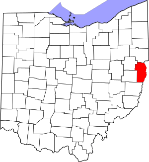
Location within the U.S. state of Ohio
|
|||
 Ohio's location within the U.S. |
|||
| Country | |||
| State | |||
| Founded | July 29, 1797 | ||
| Named for | Thomas Jefferson | ||
| Seat | Steubenville | ||
| Largest city | Steubenville | ||
| Area | |||
| • Total | 411 sq mi (1,060 km2) | ||
| • Land | 408 sq mi (1,060 km2) | ||
| • Water | 2.6 sq mi (7 km2) 0.6%% | ||
| Population
(2020)
|
|||
| • Total | 65,249 |
||
| • Density | 160/sq mi (60/km2) | ||
| Time zone | UTC−5 (Eastern) | ||
| • Summer (DST) | UTC−4 (EDT) | ||
| Congressional district | 6th | ||
Jefferson County is a place in the state of Ohio, USA. It is called a county. In 2020, about 65,249 people lived here.
The main city and government center of the county is Steubenville. Jefferson County got its name from Thomas Jefferson. He was the Vice President when the county was created.
This county is part of a larger area called the Weirton–Steubenville Metropolitan Statistical Area. It is also part of the even bigger Pittsburgh–New Castle–Weirton Combined Statistical Area.
Contents
History of Jefferson County
Jefferson County was officially started on July 29, 1797. This was six years before Ohio became a state. Governor Arthur St. Clair made the announcement.
At first, the county was very large. It covered most of northeastern Ohio. But its borders were changed many times. The county got its current shape in 1833. This happened after Carroll County was formed nearby.
Fort Steuben and Steubenville
In 1786, the United States built a fort called Fort Steuben. It was built to protect government workers. These workers were mapping the land west of the Ohio River. After they finished their job, the fort was no longer needed.
But people had already built homes around the fort. They called their settlement La Belle. When Jefferson County was created in 1797, La Belle became the county seat. Later, the town was renamed Steubenville. This was to honor the old Fort Steuben.
Growth and Industry
In the early 1800s, Steubenville was a busy port town. The rest of the county had small villages and farms. But things changed in 1856. A company built a rolling mill, which was like an early steel factory. Another company started digging for coal.
Because of these new industries, Jefferson County became very important. It was a leader in the new Industrial Revolution. This was a time when many new factories and machines were being built.
Geography of Jefferson County
Jefferson County covers about 411 square miles (1,064 square kilometers). Most of this area is land. Only a small part, about 2.6 square miles (6.7 square kilometers), is water.
Neighboring Counties
Jefferson County shares its borders with several other counties:
- Columbiana County (to the north)
- Hancock County, West Virginia (to the northeast)
- Brooke County, West Virginia (to the east)
- Ohio County, West Virginia (to the southeast)
- Belmont County (to the south)
- Harrison County (to the southwest)
- Carroll County (to the northwest)
Main Roads
Many important roads run through Jefferson County. These roads help people travel and transport goods.
 US 22
US 22 US 250
 SR 7
SR 7 SR 43
SR 43 SR 150
 SR 151
 SR 152
 SR 164
 SR 213
 SR 646
 SR 647
Population Changes
The number of people living in Jefferson County has changed a lot over the years.
| Historical population | |||
|---|---|---|---|
| Census | Pop. | %± | |
| 1800 | 8,766 | — | |
| 1810 | 17,260 | 96.9% | |
| 1820 | 18,531 | 7.4% | |
| 1830 | 22,489 | 21.4% | |
| 1840 | 25,030 | 11.3% | |
| 1850 | 29,133 | 16.4% | |
| 1860 | 26,115 | −10.4% | |
| 1870 | 29,188 | 11.8% | |
| 1880 | 33,018 | 13.1% | |
| 1890 | 39,415 | 19.4% | |
| 1900 | 44,357 | 12.5% | |
| 1910 | 65,423 | 47.5% | |
| 1920 | 77,580 | 18.6% | |
| 1930 | 88,307 | 13.8% | |
| 1940 | 98,129 | 11.1% | |
| 1950 | 96,495 | −1.7% | |
| 1960 | 99,201 | 2.8% | |
| 1970 | 96,193 | −3.0% | |
| 1980 | 91,564 | −4.8% | |
| 1990 | 80,298 | −12.3% | |
| 2000 | 73,894 | −8.0% | |
| 2010 | 69,709 | −5.7% | |
| 2020 | 65,249 | −6.4% | |
| U.S. Decennial Census 1790–1960 1900–1990 1990–2000 2020 |
|||
2010 Population Facts
In 2010, there were about 69,709 people in Jefferson County. Most people (91.9%) were white. About 5.6% were black or African American. People from other backgrounds made up smaller groups.
The average age of people in the county was about 43.9 years old. The average money earned by a family was around $47,901 per year. Some families and people lived below the poverty line, which means they had lower incomes.
Transportation
If you need to fly, the Pittsburgh International Airport is nearby. You can get there using U.S. Route 22. For smaller planes, there are two local airports: the Jefferson County Airpark and the Eddie Dew Memorial Airpark.
Ohio Route 7 is the main road that goes north and south through the county.
Education
Jefferson County has several places for learning.
Colleges and Universities
- Franciscan University of Steubenville is a university in the county.
Community and Technical Colleges
- Eastern Gateway Community College offers different types of courses.
- Trinity Health System School of Nursing trains nurses.
Public School Districts
Many public school districts serve the students in Jefferson County.
- Buckeye Local School District
- Edison Local School District
- Indian Creek Local School District
- Steubenville City School District
- Toronto City School District
High Schools
Students in Jefferson County attend several high schools.
- Buckeye Local High School
- Catholic Central High School
- Edison High School
- Indian Creek High School
- Jefferson County Christian School
- Steubenville High School
- Toronto High School
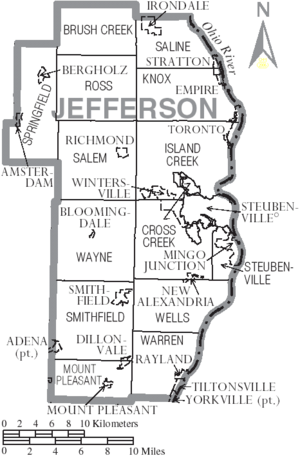
Communities in Jefferson County
Jefferson County has different types of communities.
Cities
- Steubenville (This is the county seat, where the main government offices are.)
- Toronto
Villages
Villages are smaller towns.
Townships
Townships are areas of land that include villages or rural areas.
- Brush Creek
- Cross Creek
- Island Creek
- Knox
- Mount Pleasant
- Ross
- Salem
- Saline
- Smithfield
- Springfield
- Steubenville
- Warren
- Wayne
- Wells
Census-Designated Places (CDPs)
These are areas that are like towns but are not officially incorporated as cities or villages.
Unincorporated Communities
These are smaller settlements that are not part of any city or village government.
- Alikanna
- Altamont
- Annapolis
- Belvedere
- Bradley
- Broadacre
- Calumet
- Chandler
- Circle Green
- Costonia
- Cream City
- Deandale
- Deyarmonville
- Dunglen
- Emerson
- Fairplay
- Fernwood
- Georges Run
- Gould
- Grandview Heights
- Greentown
- Hammondsville
- Herrick
- Holt
- Hopewell
- Jackson Heights
- Knoxville
- McConnelsville
- McIntyre
- Middleburg
- Monroeville
- New Somerset
- Newell
- Olszeski Town
- Osage
- Panhandle
- Parlett
- Piney Fork
- Port Homer
- Pravo
- Ramsey
- Reeds Mill
- Robyville
- Rush Run
- Shady Glen
- Smithfield (This used to be a village.)
- Unionport
- Warrenton
- Wolf Run
- Weems
- Yellow Creek
- York
Historical Community
Carpenter's Fort was a fortified house built in 1781. It was built by John Carpenter near the Ohio River. This fort was sometimes called Carpenter's Station. It is now located in Jefferson County, near Rayland, Ohio.
Community Sizes
Here is a list of the largest communities in Jefferson County, based on the 2010 census.
* Most of this town is in Harrison County.
** A small part of this town is in Belmont County.
† This is the county seat.
| Rank | City/Town/etc. | Population (2010 Census) | Type of Community |
|---|---|---|---|
| 1 | † Steubenville | 18,659 | City |
| 2 | Toronto | 5,091 | City |
| 3 | Wintersville | 3,924 | Village |
| 4 | Mingo Junction | 3,454 | Village |
| 5 | Tiltonsville | 1,372 | Village |
| 6 | Yorkville** | 1,079 | Village |
| 7 | Smithfield | 869 | Village |
| 8 | Adena* | 759 | Village |
| 9 | Dillonvale | 665 | Village |
| 10 | Bergholz | 664 | Village |
| 11 | Amsterdam | 511 | Village |
| 12 | Mount Pleasant | 478 | Village |
| 13 | Richmond | 481 | Village |
| 14 | Rayland | 417 | Village |
| 15 | Irondale | 387 | Village |
| 16 | Empire | 299 | Village |
| 17 | Stratton | 294 | Village |
| 18 | Pottery Addition | 293 | CDP |
| 19 | New Alexandria | 272 | Village |
| 20 | Bloomingdale | 202 | Village |
See also
 In Spanish: Condado de Jefferson (Ohio) para niños
 | William M. Jackson |
 | Juan E. Gilbert |
 | Neil deGrasse Tyson |


