Medicine Hat facts for kids
Quick facts for kids
Medicine Hat
|
|||||
|---|---|---|---|---|---|
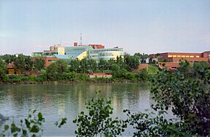
Downtown Medicine Hat overlooking the City Hall
|
|||||
|
|||||
| Nickname(s):
"The Hat", "The Gas City" "Saamis"
|
|||||
| Motto(s): | |||||
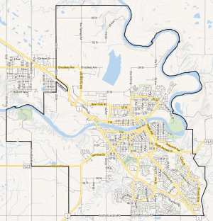
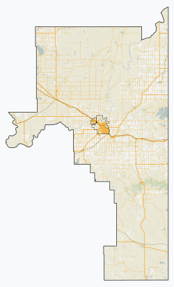
City boundaries
|
|||||
| Country | Canada | ||||
| Province | Alberta | ||||
| Planning region | South Saskatchewan | ||||
| Municipal district | Cypress County | ||||
| Founded | 1883 | ||||
| Incorporated | |||||
| • Village | May 31, 1894 | ||||
| • Town | November 1, 1898 | ||||
| • City | May 9, 1906 | ||||
| Area
(2021)
|
|||||
| • Total | 125.01 km2 (48.27 sq mi) | ||||
| • Land | 111.97 km2 (43.23 sq mi) | ||||
| Elevation | 690 m (2,260 ft) | ||||
| Population
(2021)
|
|||||
| • Total | 63,271 | ||||
| • Density | 565.1/km2 (1,464/sq mi) | ||||
| • Municipal census (2015) | 63,018 | ||||
| • Estimate (2020) | 65,527 | ||||
| Demonym(s) | Hatter | ||||
| Time zone | UTC−07:00 (MST) | ||||
| • Summer (DST) | UTC−06:00 (MDT) | ||||
| Forward sortation areas |
T1A - T1C
|
||||
| Area code(s) | 368, 403, 587, 825 | ||||
| Highways | 1, 3, 41A | ||||
| Waterways | South Saskatchewan River, Seven Persons Creek, Ross Creek | ||||
| Railways | Canadian Pacific Kansas City | ||||
Medicine Hat is a city in southeast Alberta, Canada. It sits along the South Saskatchewan River. The city is about 169 km (105 mi) east of Lethbridge and 295 km (183 mi) southeast of Calgary. Medicine Hat and the nearby town of Redcliff are both part of Cypress County. In 2021, Medicine Hat was the eighth-largest city in Alberta, with a population of 63,271 people. It is also known as the sunniest place in Canada, getting about 2,544 hours of sunshine each year!
Medicine Hat began as a town built around the railway. Today, major highways like the Trans-Canada Highway (Highway 1) and the Crowsnest Highway (Highway 3) serve the city. Other communities close by include Redcliff, Desert Blume, Dunmore, Irvine, Seven Persons, and Veinerville. The Cypress Hills are also a short drive southeast of the city.
For a long time, Medicine Hat has been famous for its huge natural gas fields. The writer Rudyard Kipling even said it had "all hell for a basement" because of them. This is why the city is often called "The Gas City."
In 2021, Medicine Hat became the first city in Canada to reach "functional zero" chronic homelessness. This means that for three months in a row, only three or fewer people were experiencing long-term homelessness. They achieved this by using a "Housing First" approach since 2009.
Contents
History of Medicine Hat
How Medicine Hat Got Its Name
The name "Medicine Hat" comes from the Blackfoot word Saamis (SA-MUS). This word means "eagle tail feather headdress," like the ones worn by medicine men. There are several old legends about how the city got its name. One story tells of a magical river serpent named Soy-yee-daa-bee – the Creator. He appeared to a hunter and told him to sacrifice his wife to gain special powers, which came from a special hat. Another legend says that during a battle between the Blackfoot and the Cree, a Cree "Medicine Man" lost his headdress in the South Saskatchewan River.
Medicine Hat has always been a popular gathering spot because of its natural features. The gentle valley, where rivers meet, and the strong native cottonwood trees attracted both bison herds and people. Before Europeans arrived, the Blackfoot, Cree, and Assiniboine nations used this area for hundreds of years. Even older Indigenous cultures lived here thousands of years ago.
Starting in 1971, archaeologists from Medicine Hat College (MHC) began digging at the Saamis Archeological Site. This site is along Seven Persons Creek, near an old Blackfoot buffalo jump. They found many old tools, bones, and pottery from early First Nations people. Most of the bones were from bison. More digs happened in 1972 and 1973. Scientists found that people lived at the Saamis Site around 1500 AD and again around 1750 AD.
Other students and teachers from MHC also dug at the Hillside Campsite in 2000. They found tools from the Old Women's Phase, but also much older items. These older finds were from the Pelican Lake Phase, dating back to between 1000 and 1500 BC.
The City's Beginnings
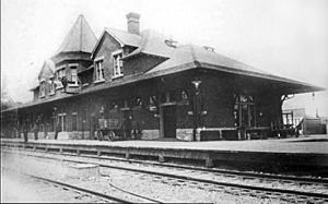
In 1883, the Canadian Pacific Railway (CPR) reached Medicine Hat and built a bridge across the river. This led to European Canadians setting up a town. They named it after the First Nations legends. As the town grew, Medicine Hat built the first hospital west of Winnipeg in 1889. The CPR made Medicine Hat an important railway stop. The settlement officially became a town on October 31, 1898. In 1905, when Alberta became a province, Medicine Hat was included. It officially became a city on May 9, 1906. The old train station is still there and has been a National Historic Site since 1992.
Medicine Hat is located about halfway between Winnipeg and Vancouver, British Columbia.
Growth and Industries
Medicine Hat had many natural resources like natural gas, coal, clay, and good farmland. Because of this, it became an industrial town. People used to call it "the Pittsburgh of the West." Many large businesses came here because energy was cheap and easy to find. Coal mines, brick factories, pottery and glass bottle makers, and flour mills all started up. Altaglass, a company that made art glass, operated here from 1950 to 1988. With the railway and river for transport, Medicine Hat became a hub for farming and its products. Between 1909 and 1914, the town had a big economic boom, and its population grew to over 10,000.
During World War II, a large camp for prisoners of war (POW) was set up here. It held German and Italian prisoners from 1943 to 1946. After the war, in the 1950s, the city started growing again.
Today, Medicine Hat is known for its good quality of life and affordable living costs. The city owns its own gas and power companies, which helps keep prices low. Important industries include chemical plants, a Goodyear tire factory, greenhouses, and many oil and gas companies. I-XL Industries, a brickworks, has been here since the 1880s. The Friends of Medalta is a group that works to save some of the city's old industrial history.
Geography and Environment
The landscape of Medicine Hat is mostly shaped by the South Saskatchewan River valley. Two smaller rivers, Seven Persons Creek and Ross Creek, also flow into the South Saskatchewan River within the city. These rivers have carved out dramatic valleys with many cliffs and narrow valleys called coulees. Outside the city and river valley, the land is mostly flat or gently rolling, with short grassy plants.
About 40 km (25 mi) to the east, you can find the Badlands Guardian Geological Feature. This is a natural land formation that looks like a head wearing a feathered headdress. It's about 1,000 ft (300 m) wide and is formed by valleys, not raised ground.
2013 Floods
In 2013, Medicine Hat experienced significant flooding during the 2013 Alberta floods. The city is on the South Saskatchewan River, which gets water from the Bow and Oldman Rivers. About 10,000 residents were asked to leave their homes before the flood hit. The river reached its highest point at 5,460 m3/s (193,000 cu ft/s), which was a lot of water, even though it was less than what was first predicted.
City Areas
Medicine Hat has many different neighbourhoods, each with its own feel. Some of the older areas were built in the 1950s and 60s, while newer ones have been developed since the 2000s. These areas offer different types of homes and are located in various parts of the city, from the river valley to higher plateaus.
- Crescent Heights is on the north side of the city, overlooking the river valley.
- Ross Glen is a family-friendly area in the southeast, developed in the late 1970s.
- Southlands is a newer community with a large shopping area, including stores like Walmart and The Home Depot.
- Southwest Hill is home to several schools and the city's hospital.
In 2018, the average price for a home in Medicine Hat was $277,294.
Climate and Weather
Medicine Hat is in a steppe region, which means it has a semi-arid climate. This climate brings cold winters and warm to hot, dry summers. During winter, warm, dry winds called Chinook winds often blow from the west, making the cold more bearable. In summer, low humidity and quick cooling in the evenings make hot days more comfortable. Medicine Hat gets less precipitation than most other cities on the Canadian Prairies and a lot of sunshine. This makes it a popular place for people to retire. Most rain falls in late spring and early summer.
The hottest temperature ever recorded in Medicine Hat was 42.2 °C (108.0 °F) on July 12, 1886. The coldest was −46.1 °C (−51.0 °F) on February 4, 1887.
| Climate data for Medicine Hat (Medicine Hat Airport) Climate ID: 3034480; coordinates 50°01′08″N 110°43′15″W / 50.01889°N 110.72083°W; elevation: 716.9 m (2,352 ft); 1981−2010 normals, extremes 1883−present |
|||||||||||||
|---|---|---|---|---|---|---|---|---|---|---|---|---|---|
| Month | Jan | Feb | Mar | Apr | May | Jun | Jul | Aug | Sep | Oct | Nov | Dec | Year |
| Record high humidex | 16.5 | 20.9 | 25.4 | 30.5 | 37.0 | 39.0 | 42.3 | 41.1 | 38.4 | 30.7 | 22.8 | 17.2 | 42.3 |
| Record high °C (°F) | 18.3 (64.9) |
21.1 (70.0) |
28.9 (84.0) |
35.6 (96.1) |
37.2 (99.0) |
41.7 (107.1) |
42.2 (108.0) |
41.1 (106.0) |
37.8 (100.0) |
33.9 (93.0) |
24.4 (75.9) |
20.0 (68.0) |
42.2 (108.0) |
| Mean daily maximum °C (°F) | −2.8 (27.0) |
0.3 (32.5) |
6.1 (43.0) |
13.9 (57.0) |
19.3 (66.7) |
23.4 (74.1) |
27.5 (81.5) |
27.0 (80.6) |
20.5 (68.9) |
13.8 (56.8) |
4.0 (39.2) |
−1.4 (29.5) |
12.7 (54.9) |
| Daily mean °C (°F) | −8.4 (16.9) |
−5.5 (22.1) |
0.1 (32.2) |
7.0 (44.6) |
12.4 (54.3) |
16.7 (62.1) |
20.0 (68.0) |
19.3 (66.7) |
13.2 (55.8) |
6.9 (44.4) |
−1.8 (28.8) |
−7.0 (19.4) |
6.1 (43.0) |
| Mean daily minimum °C (°F) | −14.1 (6.6) |
−11.3 (11.7) |
−6.0 (21.2) |
0.0 (32.0) |
5.4 (41.7) |
9.9 (49.8) |
12.4 (54.3) |
11.6 (52.9) |
5.9 (42.6) |
0.0 (32.0) |
−7.5 (18.5) |
−12.6 (9.3) |
−0.5 (31.1) |
| Record low °C (°F) | −46.1 (−51.0) |
−46.1 (−51.0) |
−38.9 (−38.0) |
−26.7 (−16.1) |
−11.1 (12.0) |
−1.1 (30.0) |
1.2 (34.2) |
−0.6 (30.9) |
−12.8 (9.0) |
−28.7 (−19.7) |
−37.8 (−36.0) |
−45.6 (−50.1) |
−46.1 (−51.0) |
| Record low wind chill | −54.2 | −50.7 | −44.5 | −31 | −12.6 | −2.9 | 0.0 | 0.0 | −12.8 | −37.6 | −49.2 | −58.9 | −58.9 |
| Average precipitation mm (inches) | 12.6 (0.50) |
7.7 (0.30) |
18.5 (0.73) |
20.4 (0.80) |
43.8 (1.72) |
65.4 (2.57) |
36.3 (1.43) |
34.2 (1.35) |
37.4 (1.47) |
19.1 (0.75) |
15.0 (0.59) |
12.1 (0.48) |
322.6 (12.70) |
| Average rainfall mm (inches) | 0.6 (0.02) |
0.4 (0.02) |
5.1 (0.20) |
14.4 (0.57) |
37.8 (1.49) |
65.4 (2.57) |
36.3 (1.43) |
33.8 (1.33) |
35.6 (1.40) |
12.3 (0.48) |
2.5 (0.10) |
0.8 (0.03) |
244.8 (9.64) |
| Average snowfall cm (inches) | 14.9 (5.9) |
9.2 (3.6) |
15.5 (6.1) |
6.3 (2.5) |
5.6 (2.2) |
0.0 (0.0) |
0.0 (0.0) |
0.4 (0.2) |
1.7 (0.7) |
6.9 (2.7) |
14.4 (5.7) |
13.3 (5.2) |
88.2 (34.7) |
| Average precipitation days (≥ 0.2 mm) | 7.7 | 6.3 | 8.4 | 7.3 | 10.2 | 10.9 | 8.3 | 6.9 | 7.6 | 5.8 | 7.3 | 7.9 | 94.7 |
| Average rainy days (≥ 0.2 mm) | 0.73 | 0.52 | 2.1 | 5.5 | 9.8 | 10.9 | 8.3 | 6.9 | 7.4 | 4.4 | 1.8 | 0.84 | 59.2 |
| Average snowy days (≥ 0.2 cm) | 7.8 | 6.4 | 7.0 | 2.9 | 1.4 | 0.0 | 0.0 | 0.04 | 0.46 | 2.2 | 6.4 | 7.7 | 42.2 |
| Mean monthly sunshine hours | 110.0 | 138.1 | 174.2 | 240.3 | 282.8 | 303.4 | 353.5 | 323.9 | 221.4 | 181.5 | 114.6 | 98.6 | 2,544.3 |
| Percent possible sunshine | 41.2 | 48.6 | 47.4 | 58.3 | 59.3 | 62.5 | 71.7 | 72.3 | 58.3 | 54.3 | 42.0 | 38.9 | 54.6 |
| Source: Environment Canada | |||||||||||||
Population and People
| Federal census population history |
||
|---|---|---|
| Year | Pop. | ±% |
| 1901 | 1,570 | — |
| 1906 | 3,050 | +94.3% |
| 1911 | 5,608 | +83.9% |
| 1916 | 9,272 | +65.3% |
| 1921 | 9,634 | +3.9% |
| 1926 | 9,536 | −1.0% |
| 1931 | 10,300 | +8.0% |
| 1936 | 9,592 | −6.9% |
| 1941 | 10,571 | +10.2% |
| 1946 | 12,859 | +21.6% |
| 1951 | 16,364 | +27.3% |
| 1956 | 20,826 | +27.3% |
| 1961 | 24,484 | +17.6% |
| 1966 | 25,574 | +4.5% |
| 1971 | 26,518 | +3.7% |
| 1976 | 32,811 | +23.7% |
| 1981 | 40,380 | +23.1% |
| 1986 | 41,804 | +3.5% |
| 1991 | 43,625 | +4.4% |
| 1996 | 46,783 | +7.2% |
| 2001 | 51,249 | +9.5% |
| 2006 | 56,997 | +11.2% |
| 2011 | 60,005 | +5.3% |
| 2016 | 63,260 | +5.4% |
| 2021 | 63,271 | +0.0% |
| Source: Statistics Canada |
||
In the 2021 Census, Medicine Hat had a population of 63,271 people. This was almost the same as its population in 2016. The city covers a land area of 111.97 km2 (43.23 sq mi).
Diversity in Medicine Hat
In 2021, most residents (85.9%) were of European background. About 9.0% were visible minorities, and 5.1% were Indigenous. The largest visible minority groups included people from South Asia (1.9%), the Philippines (1.8%), Black communities (1.5%), and China (1.0%).
Languages Spoken
According to the 2021 census, 89.6% of people in Medicine Hat said English was their first language. Other common mother tongues included German (1.3%), Tagalog (1.0%), French (0.9%), Spanish (0.9%), Arabic (0.6%), and Chinese languages (0.5%).
Religious Beliefs
In 2021, 52.8% of residents identified as Christian. This was down from 68.1% in 2011. Among Christians, 20.7% were Catholic, and 16.6% were Protestant. A large part of the population (43.1%) said they were not religious, which was an increase from 30.2% in 2011. Other religions made up 4.1% of residents, including Islam (1.5%), Sikhism (0.5%), and Hinduism (0.5%).
Fun Things to Do in Medicine Hat
The Medicine Hat Clay Industries National Historic District is like a living museum. It focuses on the old Medalta Potteries and Hycroft China Factory. You can take guided tours, join educational programs, and see exhibits about the area's industrial past. This historic district is being preserved for everyone to learn from and enjoy.
In downtown Medicine Hat, you'll find The Esplanade. This is a big cultural center with a theater that seats over 700 people. It also has an art gallery, a museum, archives, a gift shop, and a cafe. The Esplanade opened in October 2005.
The Medicine Hat Family Leisure Centre, now called Big Marble Go Centre, is the city's largest indoor sports facility. It's huge, covering 90,000 sq ft (8,000 m2). Inside, you'll find an Olympic-sized ice rink, a 50 m (160 ft) swimming pool, a waterslide, and a wave pool. It's being updated to include an indoor soccer field and a track. Outside, there are baseball diamonds, a football field, soccer fields, and a large BMX racing track.
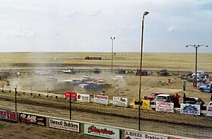
The Medicine Hat Drag Racing Association has Alberta's only official National Hot Rod Association (NHRA) track. It's a 1/4-mile track where people can race safely. The racing season usually runs from May to September. They have events with jet cars, alcohol cars, and big NHRA National Open races.
The Medicine Hat Public Library is across from The Esplanade. It has over 10,000 members and is a key resource for libraries in Southern Alberta.
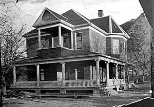
The Shannon House is a historic building from 1906. It was built by James Shannon for his family. For three generations, his family owned the property. They even ran a campground and a motel there. In 1990, a local family bought it. They turned it into the Saamis Memorial Funeral Chapel & Crematorium, keeping this important building as part of the community.
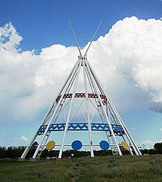
The Saamis Tepee is a giant work of art and the world's tallest teepee. It was put up in 1991 south of the Trans-Canada Highway. It stands near the Blackfoot buffalo jump and the Saamis Archeological Site. This teepee was made for the 1988 Winter Olympics in Calgary to represent Canada's Plains Indigenous peoples. It was originally 215 ft (66 m) tall (more than 20 stories) and 160 ft (49 m) wide at the bottom. The artist, Steve Illes, designed it from steel and concrete. He painted it white for purity, red for the sun, and blue for water. Inside, there are ten circles with paintings that tell stories about Plains tribes. Plaques at the base explain these stories. In 2007, strong winds damaged part of the teepee, and it had to be repaired. After repairs, it became about 15 ft (4.6 m) shorter.
Parks and Green Spaces
Medicine Hat has over 100 km (62 mi) of walking trails. All the main parks are connected by this large trail system.
- Police Point Park was once an old police outpost. It has 1.2 km2 (300-acre) of trails along the South Saskatchewan River. It's a great place for birdwatching. The Medicine Hat Interpretive Program building is there, offering nature programs.
- Strathcona Island Park is along the south bank of the South Saskatchewan River. This park has 5 km (3.1 mi) of trails, playgrounds, a water park, and ball diamonds. It's a very green park with many trees.
- Kin Coulee Park is along Seven Persons Creek. This 0.40 km2 (100-acre) park is well-kept. It has a skateboard park, ball diamonds, beach volleyball courts, and playgrounds. It's where the annual Canada Day festival and fireworks happen.
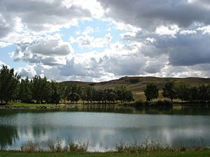
- Echodale Regional Park is a 650 km2 (250 sq mi) park with a man-made swimming lake. You can find a beach, walking trails, and places to rent canoes or paddle boats.
- Central Park is in the Southeast Hill neighbourhood. It has play structures, a spray park, and a street basketball court.
- Riverside Veterans' Memorial Park is downtown, near City Hall. It has a monument for veterans, a WWII-era Sherman tank, a brick mural, and two old Canadian Pacific Railway trains.
Sports in Medicine Hat
Medicine Hat is home to the Medicine Hat Tigers, a major junior ice hockey team in the Western Hockey League (WHL). The team started in 1970. They have won many division titles and five WHL championships. They also won the Canadian Hockey League (CHL) Memorial Cup national championships two years in a row, in 1987 and 1988. Many Tigers players have gone on to play in the National Hockey League (NHL), like Lanny McDonald. The Tigers play at Co-op Place, which opened in 2015.
The city also has the Medicine Hat Mavericks, a summer college baseball team in the Western Canadian Baseball League (WCBL). The team started in 2003 and plays at Athletic Park.
City Services and Transport
The city of Medicine Hat owns its own gas production, gas distribution, electricity generation, and electricity distribution services. This means the city provides these utilities to its citizens. The city's gas utility is one of the largest natural gas producers in Canada.
Medicine Hat is served by the Medicine Hat Airport and Medicine Hat Transit, which provides public transportation.
For healthcare, residents receive medical care at the Medicine Hat Regional Hospital.
Education in Medicine Hat
Medicine Hat has several school districts and a college.
Public Schools
Medicine Hat School District No. 76 has been serving students since 1886. It has three secondary schools: Alexandra Middle School, Crescent Heights High School, and Medicine Hat High School. There are also 12 elementary schools for Kindergarten to Grade 6. The district offers French immersion programs at one elementary school and at Crescent Heights High.
Catholic Schools
The Medicine Hat Catholic/Separate School District provides education from Kindergarten to Grade 12. They also offer French immersion programs in some schools. This district operates one high school, Monsignor McCoy, and nine other schools.
Medicine Hat also has a French-speaking school called École Les Cyprès.
Medicine Hat College
Medicine Hat College is located in the south part of the city. It first welcomed students in 1965. Now, the college has over 2,500 students and three campuses. It is an important part of the community. The college's sports teams, called the Medicine Hat College Rattlers, compete in cross-country running, basketball, volleyball, golf, soccer, and futsal.
Media and News
Medicine Hat has several radio and television stations. You can also pick up some distant AM radio stations from Calgary. The Medicine Hat News publishes a daily newspaper for the city.
Military Presence
Medicine Hat is home to the South Alberta Light Horse (SALH), an army reserve unit. The SALH has a long history, dating back to 1885. Its members have served in major wars and on United Nations and North Atlantic Treaty Organization missions overseas, including in Afghanistan.
During World War II, Medicine Hat had an airfield for the British Commonwealth Air Training Plan (at the current airport). It also had a POW camp (at the current Exhibition & Stampede grounds).
Canadian Forces Base Suffield is about 50 km (31 mi) west of the city. This base brings a lot of money to the local economy each year. It hosts the British Army Training Unit Suffield and Defence Research and Development Canada – Suffield.
Famous People from Medicine Hat
Many notable people have connections to Medicine Hat:
- Elic Ayomanor – A football player at Stanford University.
- Ronnie Burkett – A puppeteer known for his adult marionette shows.
- Terri Clark – A popular country singer.
- Amanda (Falk) Cook – A singer-songwriter and worship leader.
- Glen Edwards – A test pilot for the United States Air Force, for whom Edwards Air Force Base is named.
- Bruno Gerussi – An actor famous for his role in the TV series The Beachcombers.
- Gordie Johnson – A musician known for the band Big Sugar.
- Blaine Lacher – A former professional hockey goaltender.
- Trevor Linden – A former professional hockey player and member of the Order of Canada.
- Chris Osgood – A former professional hockey player.
- Kalan Porter – A singer-songwriter who won season 2 of Canadian Idol.
- MacKenzie Porter – A TV actress known for roles in Travelers and Hell on Wheels.
- Richard E. Taylor – A co-winner of the 1990 Nobel Prize in Physics.
- Sage Watson – An Olympic track athlete.
- Jadyn Wong – An actress known for her role in the TV series Scorpion.
See also
 In Spanish: Medicine Hat para niños
 | Valerie Thomas |
 | Frederick McKinley Jones |
 | George Edward Alcorn Jr. |
 | Thomas Mensah |


