
Sonoma, California facts for kids
Quick facts for kids
Sonoma, California
|
||
|---|---|---|
.jpg) .jpg) _(cropped).jpg) 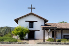 .jpg) Top: Sonoma City Hall (left) and shops around Sonoma Plaza (right); middle: shops on Spain St.; bottom: Mission San Francisco Solano (left) and Buena Vista Winery (right)
|
||
|
||

|
||

Sonoma, California
Location in the United States
|
||
| Country | United States | |
| State | California | |
| County | Sonoma | |
| laid out | 1835 | |
| Incorporated | September 3, 1883 | |
| Government | ||
| • Type | Council–manager | |
| Area | ||
| • City | 2.74 sq mi (7.11 km2) | |
| • Land | 2.74 sq mi (7.11 km2) | |
| • Water | 0.00 sq mi (0.00 km2) 0% | |
| Elevation | 85 ft (26 m) | |
| Population
(2010)
|
||
| • City | 10,739 | |
| • Estimate
(2020-04)
|
11,024 | |
| • Density | 4,017.49/sq mi (1,551.39/km2) | |
| • Metro | 483,878 | |
| Time zone | UTC-8 (Pacific) | |
| • Summer (DST) | UTC-7 (PDT) | |
| ZIP code |
95476
|
|
| Area code | 707 | |
| FIPS code | 06-72646 | |
| GNIS feature IDs | 277617, 2411929 | |

Sonoma is a city in Sonoma County, California, United States. It is located in the North Bay part of the San Francisco Bay Area. Sonoma is famous for its wineries and is a main city in California's Wine Country. It is also the center of the Sonoma Valley AVA, a special wine-growing area.
In 2020, about 10,739 people lived in Sonoma. The larger Sonoma urban area had about 32,679 people. Many tourists visit Sonoma for its wineries, events like the Sonoma International Film Festival, and its historic downtown.
The city's history began in 1823 when a Spaniard named José Altimira started Mission San Francisco Solano. This was done under the direction of Governor Luis Antonio Argüello. After the Mexican government took over the missions, a Mexican leader named Mariano G. Vallejo founded the town of Sonoma in 1835. This was on the land that used to belong to the mission.
Sonoma was General Vallejo's main base until 1846. That year, American settlers started the Bear Flag Revolt. They took over the local Mexican government and created the California Republic. This event led to the American Conquest of California.
Contents
Sonoma's Early History
When the first Spaniards arrived in the Sonoma area, it was home to several Native American groups. These included the Coast Miwok, Southern Pomo, Wappo, Suisunes, and Patwin peoples.
The Mission Era
.png)
Mission San Francisco Solano was the first step in creating the town of Sonoma. This mission was special because it was built by Mexican authorities, not the Spanish. Mexico had recently become independent from Spain. The mission was part of a bigger plan by Governor Luis Antonio Argüello. He wanted to make sure Spain had a strong presence north of the San Francisco Bay. This would help stop the Russian Empire from moving south from their settlements in Russian America.
A Franciscan priest named José Altimira worked with Governor Argüello to plan the mission. However, the head of the Spanish missions in California, José Francisco de Paula Señan, did not like the government getting involved in church matters.
About ten years later, in 1833, the Congress of the Union (the Mexican Congress) passed a law. This law, called the Mexican secularization act of 1833, ended the Catholic Church's control over large areas of land in California. One reason for this was to reduce the church's power in California's economy and government. Governor José Figueroa then chose Mariano Guadalupe Vallejo, who was a military commander, to oversee the closing of Mission San Francisco Solano. His job was to turn it into a civilian town.
General Vallejo's Time

Governor Figueroa was told by the Mexican Congress to build a strong presence north of the San Francisco Bay. This was to protect the area from foreigners. A big worry was the Russian America Company, which had settlements at Fort Ross and Bodega Bay.
Figueroa then made Lieutenant Vallejo the Military Commander of the Northern Frontier. He ordered the army units from the Presidio of San Francisco to move to the old Mission San Francisco Solano site. The Sonoma Barracks were built there to house the soldiers. Before the barracks were ready, the soldiers stayed in the old mission buildings. In 1834, George C. Yount, the first European American settler in the Napa Valley, worked as a carpenter for General Vallejo.
The Governor also gave Lieutenant Vallejo a large piece of land, about 44,000 acres (180 km2), called Rancho Petaluma. This land was just west of Sonoma. Vallejo was also put in charge of colonization. This meant he could give land grants to other settlers, with the Governor's approval.
Vallejo was also told to create a town, or pueblo, at the mission site. In 1835, with help from William A. Richardson, he planned the new town. He laid out the streets, building lots, a central plaza, and a wide main avenue. This plan followed the Spanish Laws of the Indies, which were rules for building towns.
Even though Sonoma was founded as a pueblo in 1835, it stayed under military control for a while. It did not have its own civilian government like other towns. In 1843, Vallejo, now a Lieutenant Colonel, suggested to the Governor that Sonoma should have a civil government. A town council, called an ayuntamiento, was set up in 1844. Jacobo Leese became the first alcalde (like a mayor), and Cayetano Juárez was the second.
The Bear Flag Revolt

.png)
Before dawn on June 14, 1846, 33 Americans arrived in Sonoma. They were already rebelling against the Mexican government in Alta California. Some of them had come from the camp of U.S. Army Captain John C. Frémont. He had entered California without permission in late 1845 with his exploration team. Others joined them along the way.
More and more American immigrants were coming to California. The Mexican government had stopped them from buying or renting land. They also threatened to make them leave because they had entered without official permission. Mexican officials were worried about the upcoming Mexican–American War (1846-1848) with the United States. They were also concerned about the many American and European immigrants arriving in California.
A group of these American rebels left Captain Frémont's camp on June 10. They captured 170 horses that belonged to the Mexican government. These horses were being moved by Mexican soldiers from San Rafael and Sonoma. The rebels then decided to take the weapons and gunpowder stored in the Sonoma Barracks. They wanted to stop Sonoma from being a gathering point for the Mexican forces north of San Francisco Bay.
The rebels met no resistance. They went to General Vallejo's home, and he invited their leaders inside to talk. However, the rebels outside refused to agree to the terms. Instead of letting the Mexican officers go, they insisted on holding them as hostages. William Ide gave a powerful speech, telling the rebels to stay in Sonoma and start a new republic. After this, Vallejo and three others were taken as prisoners to Captain Frémont.
The Sonoma Barracks became the main base for the 24 rebels who stayed behind. Within a few days, they created their Bear Flag. After the flag was raised, the local Mexicans called the rebels Los Osos (The Bears). This was because of their flag and their often messy appearance. The rebels liked the name, and their uprising became known as the Bear Flag Revolt. There were some small fights between the Bears and the Mexican forces, but no big battles.
When Captain Frémont heard that General José Castro was planning to attack Sonoma, he left Sutter's Fort and came to Sonoma. He met with "the Bears" and combined his forces with theirs to form one military group. Frémont then took most of the men back to Sutter's Fort, leaving 50 men to defend Sonoma. The Bear Flag Revolt ended on July 9. On that day, Lieutenant Joseph Warren Revere of the U.S. Navy raised the United States flag in front of the Sonoma Barracks. This meant the California Republic no longer existed.
After the American Takeover

After the American Conquest of California and the start of the California Gold Rush, businesses in Sonoma did well. This was because of the soldiers and the miners traveling to and from the gold fields. The good times led to people buying and selling land quickly, hoping to make money. This was tricky because the records of land ownership were often unclear.
General Vallejo had given out land grants before the town was officially organized. Also, the alcaldes (town leaders) of Alta California traditionally sold town lots. Different political groups supported different Sonoma alcaldes. This made the situation even more complicated. Some land was sold more than once. To prove a land sale was valid, you needed clear proof of who owned it before. It took over 30 years of lawsuits and arguments before land owners in Sonoma could get clear titles to their property.
.jpg)
The temporary government and U.S. military rule in California ended in 1850. That year, California became the 31st state of the United States. Sonoma was then named the first county seat for Sonoma County. Around that time, fewer miners were coming, and the U.S. Army soon left Sonoma.
Sonoma's economy went into a downturn in 1851. Nearby towns like Petaluma and Santa Rosa were growing much faster. In 1854, a special election moved the county seat and its legal work to Santa Rosa.
Modern Sonoma
The Sonoma City Hall, which is in the middle of the Sonoma Plaza, was officially opened on September 9, 1908.
The United States Navy used the Mission Inn as a rest center for soldiers during World War II.
Parts of the 1996 movie Scream were filmed in Sonoma. The Sonoma Community Center was used to look like Westboro High School in the movie.
The center of town, known as the Plaza, hosts a lively Farmers Market on Tuesdays during certain seasons.
Sonoma's Location and Climate
Geography

The city of Sonoma is located in the Sonoma Valley. The Mayacamas Mountains are to the east, and the Sonoma Mountains are to the west. A notable landform called Sears Point is to the southwest. Sonoma covers an area of about 2.7 square miles (7.1 km2).
The main stream in the town is Sonoma Creek. It flows south and eventually empties into the Napa Sonoma Marsh. Arroyo Seco Creek is another stream that joins Schell Creek in the eastern part of town.
The active Rodgers Fault is west of Sonoma Creek. However, the risk of major damage from earthquakes is lower. This is because most of the soil under the city is a firm layer of earth over strong rock. To the south, west, and east, there are deeper, rich soils. These soils are great for farming. The mountains to the north rise to about 1,200 feet (370 m) and offer a beautiful view.
Climate
Sonoma has a typical California warm-summer Mediterranean climate. This means it has hot, dry summers and cool, wet winters. Even though summers are hot, the nights are usually comfortably cool.
- In January, the average high temperature is 57.0°F (13.9°C), and the average low is 38.4°F (3.6°C).
- In July, the average high is 86.0°F (30.0°C), and the average low is 53.5°F (11.9°C).
- On average, there are about 58 days each year when the temperature reaches 90°F (32°C) or higher.
- The highest temperature ever recorded was 116°F (47°C) on July 13, 1972.
- The lowest temperature ever recorded was 13°F (-11°C) on December 22, 1990.
- Sonoma gets about 29.43 inches (748 mm) of rain each year.
- Snow is very rare. About 1 inch (2.5 cm) fell in January 1907. Snow flurries were also seen in February 1976 and in the winter of 2001.
Sonoma's Population
| Historical population | |||
|---|---|---|---|
| Census | Pop. | %± | |
| 1890 | 757 | — | |
| 1900 | 652 | −13.9% | |
| 1910 | 957 | 46.8% | |
| 1920 | 801 | −16.3% | |
| 1930 | 980 | 22.3% | |
| 1940 | 1,158 | 18.2% | |
| 1950 | 2,015 | 74.0% | |
| 1960 | 3,023 | 50.0% | |
| 1970 | 4,259 | 40.9% | |
| 1980 | 6,054 | 42.1% | |
| 1990 | 8,121 | 34.1% | |
| 2000 | 9,128 | 12.4% | |
| 2010 | 10,648 | 16.7% | |
| 2020 | 10,739 | 0.9% | |
| 2019 (est.) | 11,024 | 3.5% | |
| U.S. Decennial Census | |||
Population in 2010

The 2010 United States Census showed that Sonoma had 10,648 people. The city had about 3,883 people per square mile (1,500 people per km2).
Most people in Sonoma were White (86.8%). About 15.3% of the people were Hispanic or Latino.
In the Sonoma Valley area, 46.3% of people were White, 49.1% were Hispanic, and 2.7% were Native American. The average income for a household was $96,722.
About 97.8% of the people lived in homes. There were 4,955 households.
- 22.9% of households had children under 18.
- 42.3% were married couples.
- 38.7% of households had only one person living there.
- 21.3% had someone aged 65 or older living alone.
The average household had 2.10 people. The average family had 2.82 people.
The population was spread out by age:
- 18.0% were under 18.
- 21.1% were between 25 and 44.
- 30.5% were between 45 and 64.
- 25.0% were 65 or older.
The average age in Sonoma was 49.2 years. For every 100 females, there were about 83.6 males.
There were 5,544 housing units. About 59.1% of homes were owned by the people living in them. The other 40.9% were rented.
Population in 2000

In the census of 2000, Sonoma had 9,128 people. There were 4,373 households and 2,361 families. The city had about 3,442 people per square mile (1,329 people per km2).
Most people were White (93.80%). About 6.85% of the population was Hispanic (of any race).
There were 4,373 households.
- 21.1% had children under 18.
- 42.5% were married couples.
- 39.2% of households had only one person living there.
- 21.5% had someone aged 65 or older living alone.
The average household size was 2.07 people, and the average family size was 2.77 people.
The age breakdown was:
- 18.6% under 18.
- 23.5% from 25 to 44.
- 28.9% from 45 to 64.
- 24.2% were 65 or older.
The average age was 47 years. For every 100 females, there were about 81.5 males.
The average income for a household was $50,505. For a family, it was $65,600. The income per person in the city was $32,387. A small number of people (3.7%) and families (2.0%) lived below the poverty line.
Media and News

Sonoma has two main news sources: the Sonoma Index-Tribune and the Sonoma Valley Sun.
- The Sonoma Index-Tribune is published twice a week, on Wednesdays and Fridays. About 9,000 copies are printed.
- The Sonoma Valley Sun is published every other Thursday and is free. It is known as the alternative newspaper for the Sonoma Valley, with about 5,000 copies printed.
Sonoma also has a local radio station, KSVY, and a public-access television station, SVTV 27.
Getting Around Sonoma
Transportation
California State Route 12 is the main road in Sonoma. It goes through the populated areas of the Sonoma Valley. This road connects Sonoma to Santa Rosa in the north and Napa in the east.
State routes 121 and 116 are south of town. They pass through Schellville and connect Sonoma Valley to Napa, Petaluma to the west, and Marin County to the south.
Sonoma County Transit offers bus service from Sonoma to other places in the county. VINE Transit also has a bus route between Napa and Sonoma.
The closest airport with regular flights is Charles M. Schulz–Sonoma County Airport. It is about 30 miles (48 km) northwest of Sonoma. San Francisco International Airport and Oakland International Airport are both about 60 miles (97 km) south of Sonoma.
Famous People from Sonoma
Many notable people have connections to Sonoma:
- Hap Arnold: The first General of the United States Air Force.
- Rod Beaton: An American journalist and media executive.
- Phil Coturri: A wine expert known for starting organic and biodynamic farming methods.
- Tommy Everidge: A professional Major League Baseball player.
- Kirk Hammett: The lead guitarist and songwriter for the band Metallica.
- Agoston Haraszthy: Often called the "father of Californian wine".
- Joseph Hooker: A politician and general in the American Civil War.
- John Lasseter: An animator and former chief creative executive at Pixar.
- Tony Moll: A former NFL player.
- Brian Posehn: A comedian and actor.
- Don Sebastiani: A winemaker and politician from Sebastiani Vineyards and Winery.
- Tim Schafer: An American computer game designer and founder of Double Fine Productions.
- William Smith: An American Revolutionary War veteran believed to be buried in California.
- Tom Smothers: A comedian and musician.
- Mariano Guadalupe Vallejo: The last Mexican military commander of northern California.
- Ignazio Vella: An American businessman who served on the Sonoma County Board of Supervisors.
- Sanford Weill: Former chairman of Citicorp during the 2007–2008 financial crisis.
- Chuck Williams: The person who founded Williams Sonoma.
- Paula Wolfert and her husband William Bayer: Both authors who have lived in Sonoma since 1998.
Sister Cities
Sonoma has several sister cities around the world:
See also
 In Spanish: Sonoma para niños
