Geography of Oklahoma facts for kids
The Geography of Oklahoma is super interesting! It has all sorts of landscapes, from dry plains to thick forests and tall mountains. Oklahoma is special because it has 10 different ecological regions (areas with similar plants, animals, and climate). That's more per square mile than any other state!
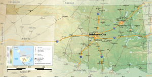
Oklahoma is located in the Great Plains and the U.S. Interior Highlands region, which is pretty much in the middle of the 48 states that touch each other. It's usually thought of as part of the South Central United States. Oklahoma shares borders with Arkansas and Missouri to the east, Kansas to the north, Colorado to the northwest, New Mexico to the far west, and Texas to the south and near-west.
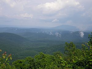
The state has four main mountain ranges: the Arbuckle Mountains, the Wichita Mountains, the Ozark Mountains, and the Ouachita Mountains. The Ozarks and Ouachitas are part of the U.S. Interior Highlands. They form one of the only big mountain areas between the Rocky Mountains and the Appalachian Mountains.
A part of the Flint Hills stretches into north-central Oklahoma. In the southeastern corner, Cavanal Hill is known as the world's tallest hill! It's 1,999 feet (609 meters) tall, just one foot short of being called a mountain. Oklahoma has more than 500 named creeks and rivers. It also has over 200 lakes created by dams, which is the most in the entire country!
Oklahoma covers about 69,898 square miles (181,035 square kilometers). Most of this is land (68,667 sq mi or 177,847 km2), with some water (1,231 sq mi or 3,188 km2). This makes it the 20th largest state in the U.S. It's generally divided into seven main geographical areas: Green Country (Northeast Oklahoma), Southeastern Oklahoma, Central Oklahoma, South Central Oklahoma, Southwest Oklahoma, Northwest Oklahoma, and the Oklahoma Panhandle.
Oklahoma's Landscape
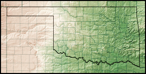
Oklahoma is located between the Great Plains and the Ozark Plateau, in an area where water flows towards the Gulf of Mexico. The land generally slopes downwards from west to east. The highest and lowest points in the state follow this pattern.
The highest point is Black Mesa, which is 4,368 feet (1,516 meters) above sea level. It's located near the far northwest corner of the Oklahoma Panhandle. The lowest point is on the Little River near the far southeastern border, at 289 feet (88 meters) above sea level.
Most of Oklahoma's water drains into two main river systems: the Red River and the Arkansas River. In the northwest, you'll find semi-arid (dry) high plains. These areas have few natural forests and mostly flat or gently rolling land, with some canyons and mesas (flat-topped hills) like the Glass Mountains.
Southwestern Oklahoma has some plains mixed with small mountain ranges, like the Antelope Hills and the Wichita Mountains. The central part of the state has a mix of prairie and woodlands. The Ozark and Ouachita (pronounced Oh-Wa-Sheet-ah) Mountains rise from west to east across the eastern third of the state. They get taller as you go further east.
Oklahoma didn't have many natural lakes. The ones that did exist were either oxbow lakes (shaped like a U, formed when a river bend is cut off) or playa lakes (shallow, temporary lakes in dry areas). There are sixty-two oxbow lakes in Oklahoma larger than 10 acres (0.04 square kilometers). The biggest one, near the Red River, is 272 acres (1.1 square kilometers).
A long drought starting in the 1930s, known as the "Dust Bowl", led to the building of many reservoirs (lakes created by dams) across the state. Now, Oklahoma has the most dam-created lakes of any state in the United States, with over 200!
Plants and Animals
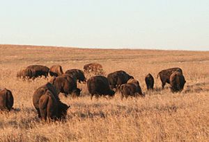
Forests cover about 24 percent of Oklahoma. The central and western parts of the state have large areas of prairie grasslands. These grasslands can be shortgrass, mixed-grass, or tallgrass prairie.
In the drier western regions, you'll mostly see shortgrass prairie and shrublands. However, pinyon pines, junipers, and ponderosa pines grow near rivers and creeks in the far western panhandle. The southeastern part of the state, known as Kiamichi Country, has marshlands, cypress forests, and a mix of shortleaf pine, loblolly pine, sabal minor, and other leafy forests. The Ozark Mountains in northeastern Oklahoma are covered with forests of post oak, elm, cedar, and pine. Some rare and special trees, like sugar maple, bigtooth maple, southern live oak, and nolina, live in Southwestern Oklahoma and the Wichita Mountains.
Oklahoma has many animals, including large groups of white-tailed deer, coyotes, bobcats, and elk. You can also find birds like quail, doves, cardinals, bald eagles, red-tailed hawks, and pheasants. In the prairie areas, american bison, greater prairie-chickens, badgers, and armadillo are common. Some of the largest prairie dog towns in the country are found in the shortgrass prairie of the state's panhandle.
The Cross Timbers is an area in Central Oklahoma where the prairie slowly changes into woodlands. It's home to 351 different kinds of vertebrate animals (animals with backbones). The Ouachita Mountains have black bear, red fox, grey fox, and river otter populations. In total, southeastern Oklahoma has 328 different vertebrate species.
Protected Natural Areas
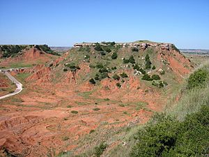
Oklahoma has 41 state parks, two national protected forests or grasslands, and many wildlife preserves and conservation areas. About six percent of the state's 10 million acres (40,000 square kilometers) of forest is public land. This includes the western parts of the Ouachita National Forest, which is the largest and oldest national forest in the southern United States.
The Tallgrass Prairie Preserve in north-central Oklahoma is 39,000 acres (158 square kilometers). It's the largest protected area of tallgrass prairie in the world. This type of ecosystem now covers only 10 percent of the land it once did, which used to spread across 14 states. Also, the Black Kettle National Grassland covers 31,300 acres (127 square kilometers) of prairie in southwestern Oklahoma.
The Wichita Mountains Wildlife Refuge is the oldest and largest of nine national wildlife refuges in the state. It was started in 1901 and covers 59,020 acres (239 square kilometers). Of Oklahoma's federally protected parks or recreation spots, the Chickasaw National Recreation Area is the biggest, at 4,500 acres (18 square kilometers). Other federal protected sites include parts of the Santa Fe and Trail of Tears national historic trails, the Fort Smith and Washita Battlefield national historic sites, and the Oklahoma City National Memorial.
Oklahoma's Climate

Oklahoma is often a meeting point for three different air masses. These are: warm, humid air from the Gulf of Mexico; warm to hot, dry air from Mexico and the Southwestern U.S.; and cold, dry air from Canada. This means that from fall to spring, Oklahoma often sees big changes in temperature and humidity. Most of the state experiences extreme temperatures, strong winds, droughts, and heavy rainfall.
Much of Oklahoma is in an area called Tornado Alley. This is where cold and warm air masses often meet, leading to severe weather. The months with the highest risk are from April to June. On average, 62 tornadoes hit the state each year, which is one of the highest rates in the world! Because of its location between different temperature and wind zones, weather patterns can change a lot over short distances within the state.
Rainfall happens all year, but it's usually lowest in the winter. It increases a lot in May, which is the wettest month almost everywhere in the state, due to frequent thunderstorms. Rainfall then decreases by mid-summer, when hot, dry weather is common in July and August. Early to mid-fall (September and October) often sees a second peak in rainfall. From late October to December, rain generally decreases again.
Eastern Oklahoma has a warm, humid subtropical climate (Köppen Cfa). This means it's heavily influenced by winds from the south that bring moisture from the Gulf of Mexico. It has hot, humid summers and generally cold winters, but with cold spells that can bring snow, sleet, or freezing rain.
As you move west, the climate gradually changes to a semi-arid zone (Köppen BSk) in the high plains of the Panhandle. This area is much drier, with somewhat colder winters and similarly hot summers, but with much lower humidity. Other central to western areas, like Lawton and Enid, are also less affected by moisture from the Gulf of Mexico and tend to be drier than eastern Oklahoma.
Rainfall and temperatures generally decrease from east to west. Areas in the southeast average an annual temperature of 62°F (17°C) and over 40 inches (1,016 mm) of rain, sometimes as high as 56 inches (1,422 mm). Meanwhile, areas of the panhandle average 58°F (14°C) with less than 17 inches (432 mm) of rain each year.
All of Oklahoma often experiences temperatures above 100°F (38°C) or below 0°F (-18°C), though subzero temperatures are rare in southeastern Oklahoma. Snowfall ranges from less than 4 inches (10 cm) in the far south to just over 20 inches (51 cm) on the border of Colorado in the panhandle. The state is home to the National Storm Prediction Center of the National Weather Service, located in Norman.
Winter and spring weather are often affected by something called the El Niño Southern Oscillation. During El Niño, winters are cooler and wetter in the western part of the state because of stronger southern winds. During La Niña, the storm track is further north, so winters are warmer and drier in western Oklahoma.
 | Mary Eliza Mahoney |
 | Susie King Taylor |
 | Ida Gray |
 | Eliza Ann Grier |


