Hurricane Bertha (2014) facts for kids
| Category 1 hurricane (SSHWS/NWS) | |
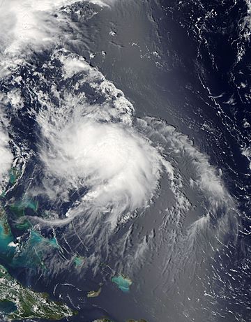
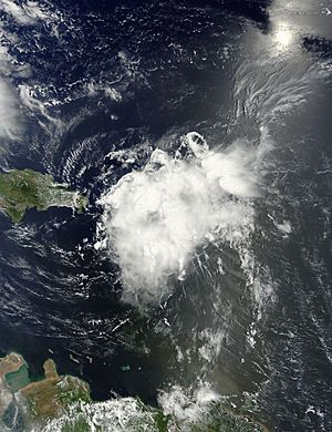
Hurricane Bertha at peak intensity northeast of the Bahamas on August 4
|
|
| Formed | August 1, 2014 |
|---|---|
| Dissipated | August 16, 2014 |
| (Extratropical after August 6) | |
| Highest winds | 1-minute sustained: 80 mph (130 km/h) |
| Lowest pressure | 998 mbar (hPa); 29.47 inHg |
| Fatalities | 3 direct, 1 indirect |
| Damage | Minimal |
| Areas affected | Lesser Antilles, Puerto Rico, Hispaniola, Cuba, Turks and Caicos Islands, The Bahamas, East Coast of the United States, Western Europe |
| Part of the 2014 Atlantic hurricane season | |
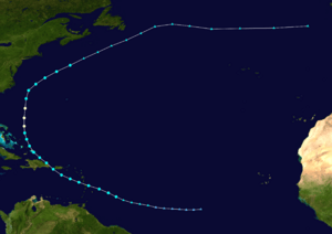
Hurricane Bertha was a powerful storm that formed in August 2014. It was the second hurricane of the 2014 Atlantic hurricane season. Bertha started as a tropical wave near the Cape Verde Islands and slowly grew stronger.
Even though it looked a bit messy on satellite, it became a tropical storm on August 1. Bertha then moved quickly across the Lesser Antilles. It even touched the northern part of Martinique. As it crossed the Caribbean Sea, it became very disorganized.
But then, on August 3, Bertha moved near the Bahamas. Here, it found better conditions and surprisingly became a hurricane on August 4. It reached its strongest winds of 80 mph (130 km/h) that day. Bertha then turned north and later northeast. It soon weakened and changed into an extratropical storm on August 6. This happened south of Nova Scotia.
The leftover storm then raced across the Atlantic Ocean. It reached the United Kingdom on August 10. After that, it moved over the North Sea and stayed there for a few days. Bertha was last seen near the Baltic Sea on August 16.
Bertha's impact was not too severe when it was a tropical storm. There were some power outages, but no major damage or deaths. However, the hurricane caused strong ocean swells and dangerous rip currents along the East Coast of the United States. Sadly, three people died, and many others needed rescuing. After Bertha became an extratropical storm, it caused bigger problems in Western Europe. The United Kingdom was hit hard with strong winds and heavy rain. This led to widespread flooding. One person also died at sea. In other parts of Europe, like Belgium, France, and Germany, small tornadoes caused some damage.
Contents
How Hurricane Bertha Formed
On July 24, 2014, a weather system called a tropical wave moved off the coast of Africa. This was near the Cape Verde Islands. Forecasters started watching it on July 26 because it had some showers and thunderstorms. They thought it might grow into a tropical storm.
At first, it was very disorganized. Experts thought it would develop slowly because the conditions were not perfect. But by July 28, the thunderstorms started to get better organized. A low-pressure area formed within the system on July 29. This made experts think it had a high chance of becoming a tropical depression.
Even though the thunderstorms faded for a bit, the low-pressure area stayed strong. On July 31, it gained tropical storm-force winds. A special aircraft called a hurricane hunter flew into the system. They found winds of 45 mph (75 km/h). Soon after, a band of deep thunderstorms formed near the center. This led to the system being named Tropical Storm Bertha on August 1. At this time, Bertha was about 345 mi (555 km) east-southeast of Barbados.
Bertha's Journey Across the Caribbean
Soon after Bertha became a tropical storm, strong winds from a trough pushed its thunderstorms away from its center. Satellite images showed a strong circulation. However, hurricane hunters found that the winds were more like a tropical wave. Around 9:00 PM UTC, Bertha passed close to the northern tip of Martinique. It had winds of 50 mph (85 km/h).
As Bertha moved into the Caribbean Sea, the strong winds continued to break it apart. Aircraft data even showed that there was no closed circulation high up in the storm. But observations from Martinique and Dominica showed there was still a circulation near the surface. So, forecasters kept watching Bertha as a tropical storm.
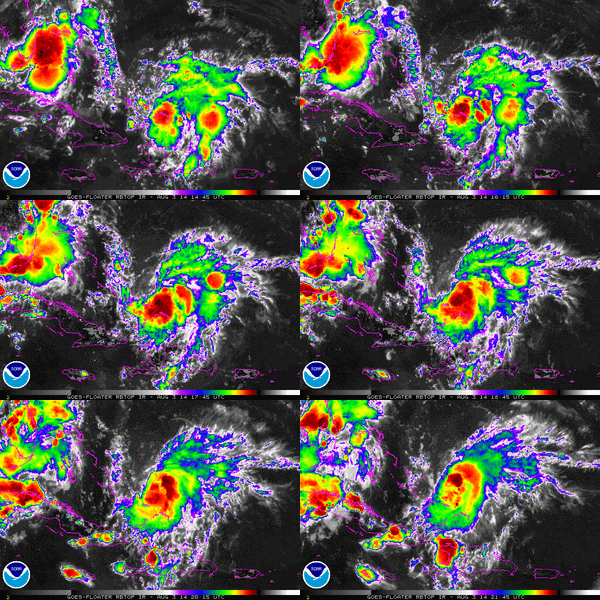
Throughout August 2, the thunderstorms slowly increased. But Bertha's center remained separate from the strongest storms. NEXRAD weather radar from San Juan, Puerto Rico showed a very disorganized storm. Experts even thought it might fall apart into an open wave as it reached Hispaniola.
Dry air, strong winds, and interaction with land made Bertha even weaker. By late August 2, it barely qualified as a tropical cyclone. Data showed no closed circulation, and some thought warnings might stop. Early on August 3, the weak storm moved through the Mona Passage. It brushed the eastern coast of the Dominican Republic before moving over the Atlantic Ocean.
As Bertha moved away from Hispaniola, it started to move more northwesterly. It followed the edge of a strong high-pressure system. Near the Turks and Caicos Islands, Bertha's circulation finally became better organized. It started to form rainbands on its eastern side. At 2:00 PM UTC, Bertha made landfall on Middle Caicos Island with winds of 45 mph (75 km/h).
After this, conditions became much better for the storm. The winds high up in the atmosphere became more favorable. There was less wind shear, more moisture, and warm sea surface temperatures. This allowed Bertha to quickly get stronger. Deep thunderstorms wrapped around the storm. Its winds reached 65 mph (100 km/h) by 3:00 AM UTC on August 4.
Early on August 4, Bertha's structure started to look messy again. The thunderstorms became smaller, and the rainbands disappeared. But the storm still had good outflow, which helped it. Despite its ragged look, hurricane hunters found that it had become a hurricane by 12:00 PM UTC. Bertha is thought to have reached its strongest point around this time. It had winds of 80 mph (130 km/h) and a pressure of 998 mbar. By this time, it was moving straight north and speeding up.
Bertha Becomes Extratropical
Through the rest of August 4 and into August 5, Bertha stayed a hurricane, even with its unusual structure. Sometimes, its center was exposed because of increasing wind shear. It sped up to the north-northeast. This happened as it moved ahead of a trough off the East Coast of the United States. Bertha weakened below hurricane strength during the night of August 4–5.
Strong wind shear kept the storm's center mostly clear of thunderstorms. Any new thunderstorms were quickly pushed away. The storm started moving more northeasterly early on August 6. It began to change into an extratropical storm. A strong jet stream connected with the system that morning. This caused thunderstorms to form away from the storm's center.
Bertha soon merged with the trough that was guiding it northeast. This merger officially changed Bertha into an extratropical system. At this point, it was about 290 mi (465 km) south-southeast of Halifax, Nova Scotia. It got a little stronger for a short time, with winds reaching 60 mph (95 km/h), before weakening again. The system then raced eastward across the Atlantic. It eventually broke apart into a trough southwest of Ireland on August 9.
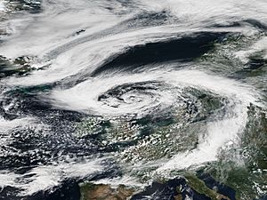
Bertha's remnants reached the United Kingdom the next day. They then moved over the North Sea. There, the storm stayed in one place for a few days. After that, it continued its eastward journey. The weakening storm moved over Scandinavia on August 14. It was last seen on August 16 near the Baltic Sea.
Bertha's Impact
Impact in the Caribbean
On August 1, Bertha crossed the Lesser Antilles. It brought strong winds and heavy rain to many islands. In Martinique, winds reached 46 mph (74 km/h) with gusts up to 54 mph (87 km/h). Many lightning strikes caused power surges. About 150,000 homes lost electricity. Power was back on for everyone by the evening of August 2. The rain was not as heavy as expected. Northern parts of the island got 1.2 to 2.4 in (30 to 60 mm) of rain. Southern areas received 0.4 to 0.8 in (10 to 20 mm).
Guadeloupe had similar effects. Wind gusts reached 57 mph (92 km/h) on La Désirade. Basse-Terre Island generally received 3.9 to 5.9 in (100 to 150 mm) of rain. There were few reports of downed trees or power lines. Overall, the damage was very small. Some rain and wind also affected Barbados.
In Dominica, the Prime Minister declared a public holiday on August 1. This allowed workers to go home before the storm. Several flights to and from Dominica and St. Lucia were canceled. Wind gusts on Dominica reached 43 mph (69 km/h). Hundreds of people lost power.
Bertha also threatened the United States Virgin Islands. This was 18 years after another Hurricane Bertha in 1996. Both storms affected the primary elections there. Voter turnout was low because of the storm. The Virgin Islands Territorial Emergency Management Agency prepared for the storm. Police officers' leave was canceled, and they worked 12-hour shifts. The Public Works Department provided sandbags and cleared storm drains. An offshore buoy near St. Thomas measured a gust of 72 mph (116 km/h). Strong winds on St. Croix broke many tree branches.
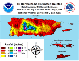
In Puerto Rico, Bertha's outer bands brought 3 to 5 in (76 to 127 mm) of rain. Some isolated areas received up to 10 in (250 mm). This rain was helpful for areas suffering from a drought. The highest rainfall was 11.11 in (282 mm) in Adjuntas. Some flooding occurred, causing two roads to partly collapse. The Río Grande de Arecibo overflowed its banks. Landslides blocked a few roads around Aceitunas. Tropical storm-force wind gusts, up to 52 mph (84 km/h), knocked down some trees and power lines. Many lightning strikes caused 29,000 homes to lose power. In Arroyo, 239 people went to public shelters for safety.
In the Dominican Republic, the Ministry of Public Works and Communications prepared for the storm. Several flights to and from Las Américas International Airport were canceled on August 2. Heavy rains, up to 4.7 in (120 mm) in Bayaguana, caused significant flooding. The Soco River overflowed its banks. Several communities were temporarily cut off by the rising waters. Seven homes were flooded in Moscú. Strong winds also knocked down many trees.
In the Southeastern Bahamas, people were warned about the storm. However, many were busy with a local boat race and did not pay attention. In the Turks and Caicos, locals moved their boats closer to shore and tied them down. Hotels took the storm threat seriously. Bertha also brought increased surf and heavy rains to parts of Cuba.
Impact on the United States East Coast

Even though Bertha stayed far offshore, its long ocean swells created dangerous rip currents along the East Coast of the United States. Two people needed rescuing off the coast of Jacksonville, Florida. Sadly, a man drowned at Mickler's Landing in Ponte Vedra Beach. Near Cape Hatteras, North Carolina, a man was pulled out to sea by rip currents. He was rescued but later died in the hospital.
Warnings were issued for offshore areas. Waves of 15 to 25 ft (4.6 to 7.6 m) were expected off the Delmarva Peninsula and New Jersey. Several people were hurt in rough seas at Rehoboth Beach, Delaware. Lifeguards performed many rescues. In Ocean City, New Jersey, 25 rescues happened on August 5. That same day, a woman almost drowned near Atlantic City after being pulled out by rip currents.
Impact in Western Europe
The leftover parts of Bertha brought heavy rains and widespread flooding to the United Kingdom. Flood warnings were issued for 6 regions. Another 47 areas had flood alerts during the storm. In London, a water pipe burst, flooding nearby streets. Thirty shops were affected, and some London Underground stations were swamped. The Prudential RideLondon race was shortened by 14 mi (23 km) because of the storm.
The River Dee rose to its highest level since 1990, flooding surrounding areas. Footbridges and paths along its banks were washed away. Lossiemouth, Scotland, received a month's worth of rain in about 12 hours. Flooding in Elgin caused 200 homes to be evacuated. Many roads were washed out across Scotland. First ScotRail reported widespread train delays. Strong winds and flooding also damaged crops, especially in Scotland.
Offshore, a person sadly died on their yacht due to rough seas and high winds. The Coastguards tried to rescue the person, but they were declared dead at the scene. Twenty boats in a sailing competition were caught in Bertha's strong winds and overturned in the Strangford Lough. A nearby hospital declared a major incident. The coast guard rushed to rescue the 97 sailors in the water. Only one person was injured, but everyone was treated for hypothermia.
Bertha's remnants also caused severe weather over mainland Europe, from France to Sweden. In southwest Germany, wind gusts reached 75 mph (120 km/h). On August 10, a small tornado outbreak happened. Tornadoes touched down in Belgium, France, and Germany. The strongest one, rated F2, hit Bad Schwalbach, Germany. It damaged 50 homes and a large area of forest. An F1 tornado hit an outdoor event in Luxembourg, Belgium, seriously injuring four people. Also, an EF1 storm traveled for 25 mi (41 km) through the Nord-Pas-de-Calais region of France. Another tornado, rated F0, touched down in Kingston upon Hull, United Kingdom, on the same day.
Alerts were also raised across Norway for possible flooding and damaging winds.


