
List of bridges, tunnels, and cuts in Hudson County, New Jersey facts for kids
Hudson County, New Jersey, is a very busy place! It's located right in the middle of the Port of New York and New Jersey, which is one of the biggest ports in the world. This area is also a major crossroads for people traveling in the New York Metropolitan area and the larger Northeast Megalopolis. Because of its location, Hudson County has many important vehicular and rail bridges, tunnels, and cuts. These structures help people and goods move across rivers, bays, and hills.
Hudson County sits on two peninsulas, which are pieces of land almost surrounded by water. It has a lot of waterfront along the Hudson River, Upper New York Bay, Kill van Kull, Newark Bay, and the Hackensack and Passaic Rivers. The main part of Hudson County is on Bergen Hill, a large hill that starts at sea level in Bayonne and rises to 260 feet as it goes through Jersey City and North Hudson. Other areas like Secaucus and West Hudson are part of the New Jersey Meadowlands, which is a large wetland area. The bridges, tunnels, and cuts listed here generally go from south to north.


Contents
Crossing the Hudson River: Tunnels and Bridges
The Hudson River is a huge waterway that separates New Jersey from New York City. To get across it, engineers built amazing tunnels and bridges. These crossings are super important for daily travel and trade.


| Crossing Name | What it Carries | Location (NJ side) | What to Know |
|---|---|---|---|
| Downtown Hudson Tubes | Port Authority Trans-Hudson (PATH trains) | Jersey City | These tunnels connect Jersey City to the World Trade Center in Manhattan. They are used by thousands of commuters every day. |
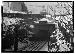
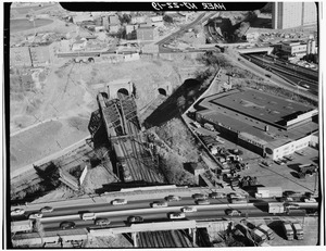
| Holland Tunnel | Jersey City | The Holland Tunnel was one of the first mechanically ventilated tunnels in the world. It carries cars and trucks under the Hudson River. | |
| Uptown Hudson Tubes | Port Authority Trans-Hudson (PATH trains) | Jersey City | These tubes connect Jersey City to different parts of Manhattan, making it easy for people to travel between the states. |
| Gateway Tunnel (proposed) |
Amtrak and New Jersey Transit trains | North Bergen | This is a planned new tunnel to help more trains cross the Hudson River, which is very busy. |
| THE Tunnel (project cancelled) |
New Jersey Transit trains | Weehawken | This tunnel project was planned to connect Secaucus Junction to Penn Station in New York, but it was stopped. |
| North River Tunnels | Amtrak and New Jersey Transit trains | Weehawken | These tunnels are used by many trains daily, connecting New Jersey to Penn Station in Midtown Manhattan. |
| Lincoln Tunnel | Weehawken | The Lincoln Tunnel has three tubes and is one of the busiest tunnels in the world, carrying millions of vehicles each year. | |
| George Washington Bridge | Fort Lee (in Bergen County, just north of Hudson County) | This famous bridge connects New Jersey to Upper Manhattan. It's one of the world's busiest motor vehicle bridges. |
Bridges Over Kill van Kull and Newark Bay
The Kill van Kull and Newark Bay are other important waterways in Hudson County. They separate parts of New Jersey from Staten Island and Newark.

| Crossing Name | What it Carries | Location | What to Know |
|---|---|---|---|
| Bayonne Bridge | Bayonne - Staten Island | This is a very tall steel arch bridge. Its deck was recently raised to allow larger ships to pass underneath. | |
| CRRNJ Newark Bay Bridge (defunct) |
Central Railroad of New Jersey trains | Bayonne - Elizabethport | This old railroad bridge is no longer in use and was taken apart in the 1980s. |
| Newark Bay Bridge | Bayonne - Newark | This bridge carries a major interstate highway and the New Jersey Turnpike over Newark Bay. | |
| Upper Bay Bridge | CSX Transportation, Norfolk Southern, Conrail freight trains | Bayonne - Newark | This bridge is used by several freight train companies to move goods. |
Bridges Over the Hackensack River
The Hackensack River flows through Hudson County, and many bridges cross it, carrying both roads and trains.


| Crossing Name | What it Carries | Location | What to Know |
|---|---|---|---|
| HD Draw (defunct) |
Old Newark and New York Railroad trains | Jersey City & Kearny Point | This was an old railroad bridge that is no longer used. |
| Lincoln Highway Hackensack River Bridge | Jersey City & Kearny Point | This bridge is part of the historic Lincoln Highway, one of the first roads to cross the United States. | |
| Pulaski Skyway | Jersey City & Kearny Point | The Pulaski Skyway is a famous elevated highway that offers great views, but it's also very busy. | |
| PATH Lift Bridge | PATH trains | Jersey City & Kearny Meadows | This bridge lifts up to let boats pass on the Hackensack River. |
| Harsimus Branch Lift | Conrail freight trains | Jersey City & Kearny Meadows | Another lift bridge for freight trains. |
| Wittpenn Bridge | Jersey City & Kearny Meadows | This bridge carries a state highway and is also a lift bridge. | |
| Lower Hack Lift | NJ Transit Morris and Essex Lines trains | Riverbend | This bridge is used by commuter trains. |
| Portal Bridge | Amtrak Northeast Corridor trains | Secaucus & Kearny Meadows | A very important bridge for Amtrak trains on the busy Northeast Corridor. |
| New Jersey Turnpike | Secaucus & Kearny Meadows | This part of the New Jersey Turnpike crosses the Hackensack River. | |
| DB Draw (Abandoned) | Norfolk Southern Railway trains | Snake Hill & Kearny Meadows | An abandoned railroad bridge. |
| Upper Hack Lift | NJ Transit Main Line trains | Harmon Cove & Kingsland | Another lift bridge for New Jersey Transit commuter trains. |
| HX Bridge | NJ Transit trains (Bergen County Line, Pascack Valley Line, Meadowlands Rail Line) | Harmon Cove & Meadowlands Sports Complex | This bridge carries multiple NJ Transit train lines. |
| Route 3 Bridge (twin span) |
Secaucus & Meadowlands Sports Complex | This bridge has two separate sections for traffic. | |
| Old Bridge (defunct) | Old Jersey City, Hoboken and Rutherford Electric Railway and Paterson Plank Road | Secaucus North End & Meadowlands Xanadu | This bridge is no longer in use. |
Bridges Over the Passaic River
The Passaic River also forms part of Hudson County's border, and it has several bridges that connect Hudson County to Newark and other areas.


| Crossing Name | What it Carries | Location | What to Know |
|---|---|---|---|
| PD Draw (defunct) |
Old Newark and New York Railroad trains | Kearny Point & Newark Ironbound | An old railroad bridge that is no longer used. |
| Lincoln Highway Passaic River Bridge | Kearny Point & Newark Ironbound | Another part of the historic Lincoln Highway. | |
| Pulaski Skyway | Kearny Point & Newark Ironbound | The Pulaski Skyway also crosses the Passaic River. | |
| Point-No-Point Bridge | Passaic and Harsimus Line freight trains | Kearny Meadows & Newark Ironbound | A bridge for freight trains. |
| Chaplain Washington–Harry Laderman Bridge | Kearny & Newark | This bridge carries the busy Interstate 95 and New Jersey Turnpike. | |
| Jackson Street Bridge | Frank E. Rodgers Boulevard | Harrison & Newark Ironbound | A local road bridge. |
| Amtrak Dock Vertical Lift | Amtrak, New Jersey Transit, and Port Authority Trans Hudson trains | Harrison & Penn Station (Newark) | A major train bridge that lifts to allow boats to pass. |
| Centre Street Bridge (defunct) |
Old New Jersey Railroad | Harrison & Newark | This old railroad bridge is no longer in use. |
| Bridge Street Bridge | Harrison & Newark | A county road bridge. | |
| Newark Drawbridge | New Jersey Transit trains | Harrison & Newark Broad Street Station | A drawbridge for commuter trains. |
| William A. Stickel Memorial Bridge | Harrison & Newark | This bridge carries Interstate 280. | |
| Clay Street Bridge | Central Avenue and Clay Street | East Newark & Newark | A local road bridge. |
| NX Bridge (abandoned/open position) | Old Erie Railroad trains | Harrison & Newark | An abandoned railroad bridge that is stuck in the open position. |
| WR Draw (not in use/closed position ) |
Old New York and Greenwood Lake Railway and Erie Railroad trains | Kearny & North Newark | This old railroad bridge is no longer used and is stuck in the closed position. |
| Belleville Turnpike Bridge | Arlington & Belleville | This bridge carries a state highway. |
Tunnels and Cuts in Bergen Hill-Hudson Palisades
Bergen Hill and the Hudson Palisades are natural hills that run through Hudson County. To build roads and railways, engineers had to dig through these hills, creating tunnels and "cuts" (open trenches).


| Railroad Tunnels, Cuts, and Viaducts | Location | Original Use | Current Use |
|---|---|---|---|
| Central Railroad of New Jersey | Bayonne and Greenville | Main train line to Communipaw Terminal | Now used by the Hudson Bergen Light Rail |
| Lehigh Valley Terminal Railway | Bayonne, Greenville, Downtown Jersey City | Jersey City, Newark and Western Railway | Now used by the National Docks Secondary for freight trains. |
| Newark and New York Railroad (1869) | West Side & Bergen-Lafayette, Jersey City | Train line from Downtown Newark to CRRNJ Terminal | Now used by the Hudson-Bergen Light Rail West Side Branch. |
| National Docks Secondary (1897) | Downtown Jersey City | Original National Docks line | Used by CSX Transportation for freight trains. |
| Bergen Hill Cut (1838) | Journal Square | Original train lines to Paulus Hook and PRR Station | Now used by PATH trains and freight trains. |
| Harsimus Stem Embankment | Harsimus & Hamilton Park | Train line to Harsimus Cove and a railroad yard | Currently unused. |
| Bergen Arches (1910) | Journal Square & Jersey City Heights | Second Erie train cut | Currently unused. |
| Long Dock Tunnel (1860) | Journal Square & Jersey City Heights | First Erie train cut | Now used by Norfolk Southern freight trains. |
| Bergen Tunnels (1876) & (1908) | Jersey City Heights | Used by Morris and Essex Railroad and Delaware, Lackawanna, and Western | Now used by New Jersey Transit trains. |
| Hoboken Elevated | Hoboken Terminal - Palisade Avenue | Old trolley lines | Taken down in 1949. |
| Gateway Tunnel (proposed) |
Amtrak and New Jersey Transit trains | North Bergen | A new train tunnel that is planned for the future. |
| THE Tunnel | North Bergen - Weehawken | New public transportation tunnel | Construction was stopped in 2010. |
| New York Tunnel Extension (1910) western entrance Bergen Portal |
North Bergen - Weehawken | Original Pennsylvania Railroad tunnels | Now used by Amtrak and New Jersey Transit trains. |
| Eldorado Cut (1893) | Weehawken | For a streetcar line to an amusement park | No longer used for its original purpose. |
| Weehawken Tunnel (1861) | North Bergen - Weehawken Port Imperial | Original New York Central train line | Now used by the Hudson Bergen Light Rail. |
| Edgewater Tunnel (1894) | Fairview - Shadyside, Edgewater (in Bergen County) | Old train cut and tunnel | Currently unused. |
| Road Cuts | What it Carries | Location | Connects |
|---|---|---|---|
| State Highway (Depressed Highway) |
Jersey City | Connects the Pulaski Skyway to the Holland Tunnel. | |
| Lincoln Tunnel Approach/Lincoln Tunnel Helix | North Hudson | Connects the New Jersey Turnpike to the Lincoln Tunnel. | |
| GWB Plaza | Fort Lee (in Bergen County) | Connects to the George Washington Bridge. | |
| There are many other roads that cut into the eastern side of the Hudson Palisades, like New York Avenue, Mountain Road, Paterson Plank Road, Wing Viaduct, Hackensack Plank Road, Shippen Street, Boulevard East, Pershing Road, Bull Ferry Road, and Gorge Road. | |||
Meadowlands Crossings
The New Jersey Meadowlands is a large area of wetlands. It also has important bridges that help trains cross. The Sawtooth Bridges carry the Northeast Corridor train lines over other train lines like NJ Transit, PATH, and Conrail.
See also
- List of bridges documented by the Historic American Engineering Record in New Jersey
- List of tunnels documented by the Historic American Engineering Record in New Jersey
- Timeline of Jersey City area railroads
