
List of rivers of Yorkshire facts for kids

_p06.68_-_Map_of_the_Yorkshire_Rivers.jpg)
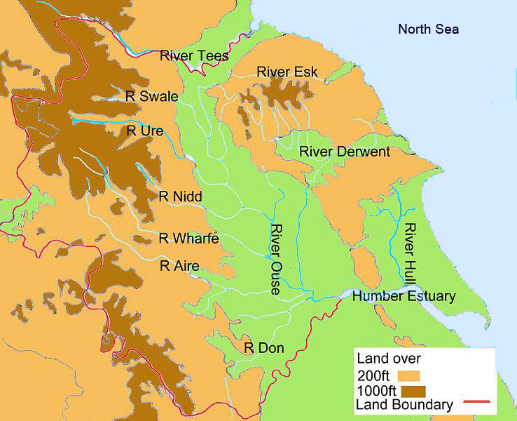
Yorkshire is a large area in England, famous for its beautiful countryside and many rivers. This article lists the main rivers that flow through Yorkshire. Some of these rivers stay entirely within Yorkshire, while others flow into or out of the area. For example, the Ribble flows towards the Irish Sea, and the Rother starts in Derbyshire. The Greta goes into Lancashire, and the Tees forms part of the border with County Durham.
The way rivers flow in Yorkshire is shaped by three big areas of high ground. These are the Pennines in the west and south, the North York Moors in the north-east, and the Yorkshire Wolds along the coast. Most of the water from these areas flows into the Vale of York and then into the North Sea through the Humber estuary. An estuary is where a river meets the sea, and the Humber is often called a river even though it's an estuary.
The Humber river system has tides that reach far inland. For example, the tide goes as far as Naburn Lock on the River Ouse. The Humber has the second biggest tidal range in the UK, meaning the difference between high and low tide can be up to 7.2 metres (24 ft). This is a lot, but the Bristol Channel has an even bigger tidal range!
The information for the river details below comes from different sources. These include the National Environment Research Council, Ordnance Survey, Environment Agency, and Google Earth. River lengths are measured from where they start or where they enter Yorkshire.
Exploring Yorkshire's Rivers: A Detailed List
This section lists many of the rivers in Yorkshire. The "source" of a river means the place where its name first appears on maps.
| Key |
|---|
| River Name | Total Length | Where it Ends (Mouth) | Mouth Elevation | Where it Starts (Source) | Source Elevation | Catchment Area |
|---|---|---|---|---|---|---|
| Aire | 114 km 71 miles |
River Ouse, Yorkshire near Airmyn | 3 m 9.8 ft |
Malham Tarn | 377 m 1,237 ft |
856 km² 331 sq miles |
| Arkle Beck | 17 km approx | River Swale at Reeth | 177 m | Arkengarthdale Moor | 477 m | |
| Ashfold Side Beck | 9 km Approx | River Nidd near Pateley Bridge | 117 m | Ashfold Gill Head | 504 m | |
| Bain | 3.95 km 2.45 miles |
River Ure near Bainbridge | 210 m 690 ft |
Semer Water | 252 m 827 ft |
Not available |
| Barney Beck | 6 km approx | River Swale at Healaugh | 186 m | Reeth High Moor | 451m | Not available |
| Birkdale Beck | 6 km approx | River Swale near Keld | 341 m | Beck Meetings | 455 m | Not available |
| Bishopdale Beck | 11 km approx | River Ure near Aysgarth | 144 m | Dale Head | 218 m | Not available |
| River Burn | 13 km approx | River Ure at Masham | 70 m | Masham Moor | 292 m | |
| Calder | 71 km 44 miles |
River Aire | 14 m 46 ft |
Heald Moor, near Todmorden | 220 m 720 ft |
930 km² 360 sq miles |
| Colne | 20.6 km 12.8 miles |
River Calder near Bradley | 52 m 171 ft |
Where Redbrook Clough and Haigh Clough meet | 234 m 768 ft |
245 km² 95 sq miles |
| Cover | 22 km 14 miles |
River Ure near Middleham | 98 m 322 ft |
Great Hunters Sleets near Woodale | 487 m 1,598 ft |
Not available |
| Crimple | 25 km | River Nidd near Wetherby | 21 m | Crimple Head Farm | 221 m | |
| Dearne | 51.9 km 32.2 miles |
River Don near Conisbrough | 17 m 56 ft |
Birdsedge near Denby Dale | 319 m 1,047 ft |
310.8 km² 120 sq miles |
| Derwent | 115.1 km 71.5 miles |
River Ouse at Barmby on the Marsh | 10 m 33 ft |
Derwent Head near RAF Fylingdales | 260 m 850 ft |
1,634 km² 631 sq miles |
| Dibb | 5.2 km 3.2 miles |
River Wharfe near Appletreewick | 143 m 469 ft |
Grimwith Reservoir | 253 m 830 ft |
25.5 km² 9.8 sq miles |
| Doe | 5.92 km 3.68 miles |
Where it meets River Twiss at Ingleton | 118 m 387 ft |
God's Bridge near Chapel-Le-Dale | 234 m 768 ft |
Not available |
| Don | 114.1 km 70.9 miles |
River Ouse at Goole | 3 m 9.8 ft |
Where Great Grains Clough and Black Grough meet near Winscar Reservoir, Dunford Bridge | 416 m 1,365 ft |
1,256.2 km² 485 sq miles |
| Dove, North Yorks | 30.22 km 18.78 miiles |
River Rye near Salton | 24 m 79 ft |
Farndale Moor, North Yorkshire | 372 m 1,220 ft |
59.2 km² 22.9 sq miles |
| Dove, South Yorks | 7.91 km 4.92 miles |
River Dearne near Darfield, South Yorkshire | 22 m 72 ft |
Worsbrough Reservoir | 56 m 184 ft |
Not available |
| Earby Beck | River Aire near Skipton | m | Foulridge | m | Not available | |
| Eastburn Beck | Kellythorpe | 14 m | Kirkburn | 22 m | Not available | |
| Eller Beck | Beck Hole | 59 m | Allerston High Moor | 253 m | Not available | |
| Eshton Beck | Gargrave | 102 m | Winterburn | 149 m | Not available | |
| Esk | 45 km 28 miles |
North Sea at Whitby | 0 m 0 ft |
The Esklets near Westerdale | 251 m 823 ft |
308 km² 119 sq miles |
| Ewden Beck | River Don at Wharncliffe Side | 106 m | Margery Hill | 541 m | Not available | |
| Foss | 31 km 19 miles |
River Ouse, York | 12 m 39 ft |
Near Oulston Reservoir, Yearsley | 160 m 520 ft |
118 km² 46 sq miles |
| Foulness | 25.51 km 15.85 mi |
Market Weighton Canal | 1 m 3 ft |
Shiptonthorpe | 20 m 66 ft |
N/A |
| Greta | 7.55 km 4.69 miles |
Leaves Yorkshire near Burton-in-Lonsdale | 64 m 210 ft |
Where River Doe and River Twiss meet at Ingleton | 118 m 387 ft |
86.1 km² 33.2 sq miles |
| Hedon Haven/Burstwick Drain | 12 kilometres (7.5 mi) | Paull | 0 metres (0 ft) | Elstronwick | 5 metres (16 ft) | 26 square kilometres (10 sq mi) |
| Hertford | 16 km approx | River Derwent at Binnington Carr | 23 m | Hunmanby | 49 m | |
| Holme | 13.86 km 8.61 miles |
River Colne at Huddersfield | 72 m 236 ft |
Holmbridge | 188 m 617 ft |
97.4 km² 37.6 sq miles |
| How Stean Beck | 6 km Approx | River Nidd at Lofthouse | 157 m | 338 m | ||
| Hull | 46.84 km 29.11 miles |
Humber estuary at Kingston upon Hull | 0 m 0 ft |
Where Driffield Trout Stream and Little Driffield Beck meet | 17 m 56 ft |
378.1 km² 146 sq miles |
| Humber | 61.9 km 38.5 miles |
North Sea at Spurn Head | 0 m 0 ft |
Trent Falls | 0 m 0 ft |
Not available without Trent Basin |
| Kyle | 9.31 km 5.78 miles |
River Ouse near Newton-on-Ouse | 11 m 36 ft |
Where Derrings Beck and Carle Beck meet near Tholthorpe | 12 m 39 ft |
Not available |
| Laver | 15 km 9.3 miles |
River Skell near Ripon | 33 m 108 ft |
Where North Gill Beck and South Gill Beck meet at Dallowgill | 170 m 560 ft |
Not available |
| Leven | 46.2 km 28.7 miles |
River Tees near Yarm | 16 m 52 ft |
Kildale Moor, North Yorks | 279 m 915 ft |
196.3 km² 75.8 sq miles |
| Little Don River | 14 km approx | River Don near Stocksbridge | 132 m | Harden Moor | 348 m | |
| Loxley | 16 km 9.9 miles |
River Don, South Yorkshire at Owlerton | 58 m 190 ft |
Damflask Reservoir near Stacey Bank | 133 m 436 ft |
43.5 km² 27 sq miles |
| Nidd | 95.45 km 59.31 miles |
River Ouse at Nun Monkton | 13 m 43 ft |
Nidd Heads on Great Whernside | 660 m 2,170 ft |
516 km² 199 sq miles |
| Ouse | 84 km 52 miles |
Trent Falls | 0 m 0 ft |
River Ure at Cuddy Shaw Reach | 12 m 39 ft |
3,315 km² 1,280 sq miles |
| Ribble | 38.48 km 23.91 miles |
County Border near Swinden | 117 m 384 ft |
Ribble Head | 290 m 950 ft |
204 km² 79 sq miles |
| Riccall | 18.36 km 11.41 miles |
River Rye | 24 m 79 ft |
Where Bonfield Gill and Bogmire Gill meet near Helmsley | 130 m 430 ft |
57.6 km² 22.2 sq miles |
| Rivelin | 6.81 km 4.23 miles |
River Loxley | 77 m 253 ft |
Rivelin Dams near Sheffield | 206 m 676 ft |
Not available |
| Rother | 16.77 km 10.42 miles |
River Don at Rotherham | 26 m 85 ft |
County Boundary at Eckington | 47 m 154 ft |
352.2 km² 136 sq miles |
| Ryburn | 11.4 km 7.1 miles |
River Calder at Sowerby Bridge | 80 m 260 ft |
Where unnamed stream and Black Castle Clough meet near Rishworth | 361 m 1,184 ft |
13 sq miles |
| Rye | 61.5 km 38.2 miles |
River Derwent near Malton | 19 m 62 ft |
Rye Head near Osmotherley | 302 m 991 ft |
679 km² 262 sq miles |
| Ryton | 3.4 km 2.1 miles |
County Border with Nottinghamshire | 48 m 157 ft |
Where Anston Brook and Pudding Dike meet | 71 m 233 ft |
77 km² 30 sq miles |
| Seven | 34.9 km 21.7 miles |
River Rye | 22 m 72 ft |
Danby High Moor near Rosedale Abbey | 330 m 1,080 ft |
121.6 km² 47 sq miles |
| Sheaf | 9.6 km 6 miles |
River Don | 53 m 174 ft |
Where Oldhay Brook and Totley Brook meet | 143 m 469 ft |
49.1 km² 19 sq miles |
| Skell | 19 km 12 miles |
River Ure near Ripon | 23 m 75 ft |
Howson Ridge near Wath-in-Nidderdale | 350 m 1150 ft |
Not available |
| Skirfare | 15.24 km 9.47 miles |
River Wharfe | 197 m 646 ft |
Where Foxup Beck and Cosh Beck meet | 313 m 1,027 ft |
Not available |
| Spen | 8 km 5 miles |
River Calder at Dewsbury | 42 m 138 ft |
Where Hunsworth Beck and Nann Hall Beck meet in Cleckheaton | 81 m 266 ft |
46.3 km² 17.9 sq miles |
| Swale | 117.8 km 73.2 miles |
River Ure | 11 m 36.09 ft |
Where Birkdale Beck and Great Sleddale Beck meet | 366 m 1,200 ft |
1,363 km² 526 sq miles |
| Tees | 88.4 km 54.9 miles |
North Sea at Redcar | 0 m 0 ft |
Enters Yorkshire at Gainford | 67 m 220 ft |
1,264 km² 488 sq miles |
| Tutt | 12 km approx | River Ure at Boroughbridge | 11 m | Nidd | 61 m | |
| Twiss | 4.17 km 2.59 miles |
Where it meets River Doe at Ingleton | 118 m 387 ft |
Keld Head | 264 km 866 ft |
Not available |
| Ure | 118 km 73 miles |
Cuddy Shaw Reach where it becomes the River Ouse | 12 m 39 ft |
Ure Head near Abbotside | 635 m 2,083 ft |
914.6 km² 353.1 sq miles |
| Washburn | 26 km 16 miles |
River Wharfe near Pool | 49 m 161 ft |
Washburn Head | 391 m 1,283 ft |
87.3 km² 54.2 sq miles |
| Wenning | 13 km approx |
Yorkshire/Lancashire boundary at Bentham | 54 m | Clapham | 124 m | |
| Wharfe | 97 km 60 miles |
River Ouse at Wharfe's Mouth, near Cawood | 4.9 m 16 ft |
Beckermonds, Langstrothdale Chase | 310 m 1,020 ft |
818 km² 316 sq miles |
| Went | 26.7 km 16.6 miles |
River Don near Snaith | 5 m 16 ft |
Where Went Beck and Hessle Beck meet at Low Ackworth | 32 m 105 ft |
87.3 km² 33.7 sq miles |
| Wiske | 46.9 km 29.1 miles |
River Swale near Kirby Wiske | 21 m 69 ft |
Where Stony Lane Beck and Carr Beck meet near Ingleby Arncliffe | 69 m 226 ft |
215.5 km² 83.2 sq miles |
| Worth | 15.2 km 9.4 miles |
River Aire near Keighley | 88 m 289 ft |
Watersheddles Reservoir | 329 m 1,079 ft |
71.7 km² 27.7 sq miles |
Map of Yorkshire's Rivers
Images for kids
-
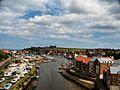
The River Esk at Whitby
-
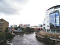
The River Aire and the Leeds-Liverpool canal in Leeds
-
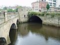
River Sheaf joins River Don at Sheffield
-
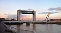
Tidal Barrier on the River Hull at Kingston upon Hull
-
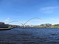
Infinity Bridge on River Tees in the Borough of Stockton-on-Tees
-
The road bridge at Stamford Bridge over the River Derwent
-
River Wharfe at Tadcaster
-
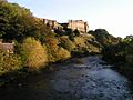
Richmond Castle and the River Swale
-
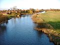
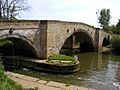
River Ure at Boroughbridge
-
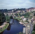
River Nidd and railway viaduct at Knaresborough


.jpg)


