
Siskiyou County, California facts for kids
Quick facts for kids
Siskiyou County, California
|
|||
|---|---|---|---|
| County of Siskiyou | |||
     Images, from top down, left to right: Mount Shasta, the historic West Miner Street in Yreka, Indian Tom Lake, Captain Jack's Stronghold in the Lava Beds National Monument, the McCloud River
|
|||
|
|||
| Motto(s):
"Mountains of Opportunity"
|
|||

Location in the state of California
|
|||
| Country | United States | ||
| State | California | ||
| Region | Shasta Cascade | ||
| Incorporated | March 22, 1852 | ||
| Named for | The Siskiyou Trail | ||
| County seat | Yreka | ||
| Largest city | Yreka | ||
| Government | |||
| • Type | Council–Administrator | ||
| Area | |||
| • Total | 6,347 sq mi (16,440 km2) | ||
| • Land | 6,278 sq mi (16,260 km2) | ||
| • Water | 69 sq mi (180 km2) | ||
| Highest elevation | 14,162 ft (4,317 m) | ||
| Population | |||
| • Total | 44,076 | ||
| • Density | 6.9444/sq mi (2.68124/km2) | ||
| GDP | |||
| • Total | $2.008 billion (2022) | ||
| Time zone | UTC−8 (Pacific Time Zone) | ||
| • Summer (DST) | UTC−7 (Pacific Daylight Time) | ||
| Area code | 530 | ||
| FIPS code | 06-093 | ||
| GNIS feature ID | 277311 | ||
| Congressional district | 1st | ||


Siskiyou County (pronounced SISK-yoo) is a county in the northwest part of California. In 2020, about 44,076 people lived there. The main city and county seat is Yreka. The county's highest point is Mount Shasta.
Siskiyou County is in the Shasta Cascade region, right next to the Oregon border. It's a popular place for tourists. People come to enjoy outdoor activities, see Mount Shasta and the McCloud River, and learn about the area's Gold Rush history.
Contents
History of Siskiyou County
Siskiyou County was created on March 22, 1852. It was formed from parts of Shasta and Klamath Counties. The county was named after the Siskiyou mountain range. Later, in 1855, some of its land was given to Modoc County.
The Siskiyou Trail
The county is home to a big part of the Siskiyou Trail. This trail was an important path between California's Central Valley and the Pacific Northwest. The Siskiyou Trail first followed paths made by Native Americans. In the 1830s, Hudson's Bay Company trappers made it longer. During the California gold rush, "Forty-Niners" also used and extended the trail.
Gold Rush and Early Settlements
In 1851, a lot of gold was found near what is now Yreka, California. This discovery brought many gold seekers to the area. The writer Joaquin Miller wrote about this time in his book Life Amongst the Modocs.
Railroads and Tourism
In the mid-1880s, the Central Pacific Railroad was built along the Siskiyou Trail. This brought the first wave of tourists to the county. Visitors loved the many summer resorts. They also came to hunt or fish in the wild region. The Southern Pacific railroad, which took over the Central Pacific, called its route “The Road of A Thousand Wonders.”
The State of Jefferson Movement
In the early 1940s, Siskiyou County was part of the "State of Jefferson" movement. This was a plan to create a new state. It would include several counties from northern California and southern Oregon. This idea has become popular again in recent years.
Origin of the Name Siskiyou
The exact origin of the word Siskiyou is not fully known. One idea is that it comes from a Chinook Jargon word. This word meant "bob-tailed horse." Another idea, suggested in 1852, is that it comes from the French words Six Cailloux. This means "six stones." This name was supposedly given to a river crossing on the Umpqua River in 1832. Some also say the "Six Cailloux" name was used for a crossing on the Klamath River near Hornbrook.
Recent History
The county is home to the Black Bear Ranch. This was a community started in 1968 with the slogan "Free Land for free people." On September 4, 2013, the Siskiyou County Board of Supervisors voted to separate from California.
Geography of Siskiyou County

Siskiyou County covers about 6,347 square miles. Most of this (6,278 square miles) is land, and 69 square miles (1.1%) is water. It is the fifth-largest county by area in California.
Landscapes and Waterways
Siskiyou County has many different types of landscapes. You can find tall mountains like Mount Shasta (14,179 feet high) in the center. There are also lakes, thick forests, deserts, and beautiful waterfalls. The county has famous rivers and streams for trout fishing, like the Sacramento and McCloud rivers. Many lakes and reservoirs are also here, such as Castle Lake and Lake Siskiyou. Mount Shasta even has a place for winter sports.
In the western part of the county, Scott Valley has wide, tree-lined meadows. These meadows support large cattle ranches. The northeastern parts of the county, like Butte Valley, have very rich soil. This soil helps grow crops like alfalfa, potatoes, and horseradish. Nurseries in Butte Valley are a top source for strawberry plants in North America.
Forests and Unique Trees
Much of the county is covered with thick forests. You'll find pine, fir, incense-cedar, oak, and madrone trees. Siskiyou County is also home to the rare Baker's Cypress Tree, Cupressus bakeri. This tree grows in only eleven places in the world, and five of those are in Siskiyou County.
Today, the county's natural areas are mostly used for fun activities. These include skiing, snowboarding, hiking, mountain biking, camping, and exploring the wilderness. Old logging practices have mostly stopped because of environmental rules. The county's water is very clean and plentiful. Because of this, a lot of bottled water from Siskiyou County is sold across the country. A large Crystal Geyser plant is located near Weed, at the base of Mount Shasta.
Flora and Fauna
Large parts of Siskiyou County are covered by forests in the Siskiyou and Cascade Ranges. These include many oak woodlands and mixed conifer forests. The California Buckeye tree, which is common in California, reaches its northern limit here. The Klamath National Forest covers 1.7 million acres. Parts of this forest are in Siskiyou County and also in Jackson County, Oregon.
Neighboring Counties
Siskiyou County shares borders with several other counties:
- Josephine County, Oregon - northwest
- Jackson County, Oregon - north
- Klamath County, Oregon - northeast
- Modoc County - east
- Shasta County - southeast
- Trinity County - south
- Humboldt County - southwest
- Del Norte County - west
Protected Natural Areas
Several national protected areas are found in or near Siskiyou County:
- Butte Valley National Grassland
- Klamath National Forest (part)
- Lava Beds National Monument (part)
- Lower Klamath National Wildlife Refuge (part)
- Modoc National Forest (part)
- Rogue River National Forest (part)
- Shasta National Forest (part)
- Six Rivers National Forest (part)
- Tule Lake National Wildlife Refuge (part)
- Tule Lake Unit, World War II Valor in the Pacific National Monument (part)
Transportation in Siskiyou County

Main Roads
 Interstate 5
 U.S. Route 97
 State Route 3
 State Route 89
 State Route 96
 State Route 139
 State Route 161
 State Route 263
 State Route 265
Public Transport
Siskiyou Transit And General Express (STAGE) runs buses that connect the more populated areas of the county. Amtrak trains stop in Dunsmuir. Greyhound buses also travel through the county on Interstate 5, with a stop in Weed.
Airports
Siskiyou County owns and runs several small airports for general aviation. These include Butte Valley Airport, Happy Camp Airport, Scott Valley Airport, Siskiyou County Airport, and Weed Airport. Other airports in the county are Dunsmuir Municipal-Mott Airport and Montague-Yreka Rohrer Field.
For bigger commercial flights, the closest airports are:
- Rogue Valley International-Medford Airport in Medford, Oregon (north of the county).
- Crater Lake–Klamath Regional Airport in Klamath Falls, Oregon (northeast of the county).
- Redding Municipal Airport in Redding, California (south of the county).
People of Siskiyou County
Population Overview
In 2020, Siskiyou County had a population of 44,076 people. The county's population has changed over the years. In 1860, there were 7,629 people, and it grew to 44,900 by 2010.
Racial and Ethnic Backgrounds
The county is home to people from many different backgrounds. In 2020, about 72.73% of the population was White (not Hispanic or Latino). Other groups included:
- Native American: 3.99%
- Asian: 1.96%
- Black or African American: 1.07%
- Pacific Islander: 0.09%
- People of two or more races: 7.02%
- Hispanic or Latino (of any race): 12.54%
In 2000, the average age in the county was 43 years old. About 24% of the population was under 18.
Communities in Siskiyou County

Cities
- Dorris
- Dunsmuir
- Etna
- Fort Jones
- Montague
- Mount Shasta
- Tulelake
- Weed
- Yreka (This is the county seat, where the main government offices are.)
Census-Designated Places (CDPs)
These are areas that are like towns but are not officially incorporated as cities.
- Carrick
- Edgewood
- Gazelle
- Greenview
- Grenada
- Happy Camp
- Hornbrook
- Lake Shastina
- Macdoel
- McCloud
- Mount Hebron
- Tennant
Other Unincorporated Communities
These are smaller communities that are not part of a city or CDP.
- Ager
- Bestville
- Black Bear
- Callahan
- Cecilville
- Forks of Salmon
- Hamburg
- Hatfield (partial)
- Hilt
- Horse Creek
- Klamath River
- Little Shasta
- Oro Fino
- Pondosa
- Sawyers Bar
- Scott Bar
- Seiad Valley
- Somes Bar
Ghost Towns
These are towns that used to exist but are now abandoned.
Largest Communities by Population (2020)
Here are the largest communities in Siskiyou County based on the 2020 census:
| Rank | City/Town/etc. | Type | Population (2020 Census) |
|---|---|---|---|
| 1 | † Yreka | City | 7,807 |
| 2 | Mount Shasta | City | 3,223 |
| 3 | Weed | City | 2,862 |
| 4 | Lake Shastina | CDP | 2,401 |
| 5 | Dunsmuir | City | 1,707 |
| 6 | Montague | City | 1,226 |
| 7 | McCloud | CDP | 945 |
| 8 | Happy Camp | CDP | 905 |
| 9 | Tulelake | City | 902 |
| 10 | Dorris | City | 860 |
| 11 | Fort Jones | City | 695 |
| 12 | Etna | City | 678 |
| 13 | Karuk Reservation | AIAN | 578 |
| 14 | Grenada | CDP | 314 |
| 15 | Hornbrook | CDP | 266 |
| 16 | Greenview | CDP | 208 |
| 17 | Quartz Valley Reservation | AIAN | 202 |
| 18 | Carrick | CDP | 143 |
| 19 | Mount Hebron | CDP | 103 |
| 20 | Gazelle | CDP | 95 |
| 21 | Macdoel | CDP | 86 |
| 22 | Edgewood | CDP | 72 |
| 23 | Tennant | CDP | 63 |
Images for kids
-
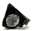
Cristobalite on obsidian, a type of rock found near Lava Beds National Monument.

See also
 In Spanish: Condado de Siskiyou para niños
