
Carlisle facts for kids
Quick facts for kids Carlisle |
|
|---|---|
| City | |
|
The city skyline, cathedral, old town hall, citadel and castle |
|
Coat of arms |
|

Carlisle
|
|
| Population | 70,503 (2021) |
| OS grid reference | NY395555 |
| • London | 261 mi (420 km) SSE |
| Unitary authority |
|
| Ceremonial county | |
| Region | |
| Country | England |
| Sovereign state | United Kingdom |
| Post town | CARLISLE |
| Postcode district | CA1-CA6 |
| Dialling code | 01228 |
| Police | Cumbria |
| Fire | Cumbria |
| Ambulance | North West |
| EU Parliament | North West England |
| UK Parliament |
|


.jpg)
Carlisle (/kɑːrˈlaɪl/ KAR-lyle) is a historic city in Cumbria, England. It is the main city for the Cumberland Council area.
Carlisle's story began with a settlement that supported castles along Hadrian's Wall. Because it is close to Scotland (only 8 miles south of the border), Carlisle Castle and the city became a very important military base in the Middle Ages. Mary, Queen of Scots was even held prisoner in the castle in 1568. Today, the castle is home to the Duke of Lancaster's Regiment and the Border Regiment Museum.
In the early 1100s, a church was built, which became Carlisle Cathedral in 1133. This meant Carlisle officially became a city. Later, in the 1800s, factories for making textiles changed Carlisle into a busy mill town. Its location also made it a key railway town, with many train lines meeting at Carlisle railway station. Carlisle is sometimes called the 'Great Border City'. Today, it is a big cultural, business, and industrial hub in Britain.
Contents
- Carlisle's Past: A Journey Through Time
- Carlisle City Centre: A Walk Around
- City Centre Views
- How Carlisle is Governed
- Carlisle's Location and Weather
- Transportation in Carlisle
- Carlisle's Businesses and Factories
- Learning in Carlisle
- Carlisle's Culture and Arts
- Sports in Carlisle
- Carlisle's Military Connections
- Carlisle's Legends and Folklore
- Carlisle's International Connections
- See also
Carlisle's Past: A Journey Through Time
Ancient Carlisle: Roman Times
We learn about ancient Carlisle mostly from old Roman writings and things found by archaeologists. The first people living here were the Carvetii tribe. They were Britons who lived in what is now Cumbria. Some old writers say Carlisle was a strong British town even before the Romans arrived.
The Romans built a fort where Carlisle Castle is now, around AD 73. It was in a good spot on a Roman road, overlooking two rivers. This fort was rebuilt in AD 83 using strong oak wood. It was guarded by 500 cavalry soldiers.

By the early 100s, Carlisle was a major stronghold. In 122, Emperor Hadrian visited and decided to build a wall across Britain. A new, larger fort called Petriana was built in the Stanwix area of the city, north of the river. It was the biggest fort on Hadrian's Wall.
Carlisle in the Middle Ages

After the Romans left, the area became the British kingdom of Rheged. Carlisle was likely its main city. Later, the region was fought over by different groups, including the Kingdom of Strathclyde and the kingdom of Northumbria.
In 1092, William Rufus, son of William the Conqueror, took control of Carlisle and made it part of England. Building of Carlisle Castle started in 1093 on the old Roman fort site. The castle and city walls were rebuilt in stone in 1112. The walls had three gates: the Irish or Caldew Gate, the English or Botcher Gate, and the Scotch or Ricker Gate. You can still see these names in Carlisle's road names today.
Carlisle Cathedral began as a church and became a cathedral in 1133. In 1157, Carlisle became the main city for the new county of Cumberland.
Because it was so close to the border, Carlisle was often involved in wars between Scotland and England. Life was tough for people living here. Groups called the Border Reivers often raided and stole from each other. In 1525, the Archbishop of Glasgow even put a curse on all the Reivers!
Carlisle in Early Modern Times

After 1539, King Henry VIII had Carlisle's defenses updated. The castle towers were changed to hold cannons, and the old Bochard gate became the Carlisle Citadel, a strong fort with two big cannon towers.
When James VI of Scotland also became King of England in 1603, it helped stop the Reivers. Many were punished or sent away. By 1681, the Reiver problem was finally over.
During the English Civil War in 1642, Carlisle Castle supported the King. It was under a long siege from 1644 to 1645. After the Royalist forces gave up, the city was taken over. In 1646, parts of the cathedral's nave were destroyed to get stone to rebuild the castle. Carlisle remained a military base for a long time.
In 1707, England and Scotland joined to form Great Britain. But Carlisle was still a garrison town. The city's last siege happened in 1745, when Charles Edward Stuart (Bonnie Prince Charlie) took Carlisle during the Jacobite Rising of 1745. When the Jacobites left, they left 400 men in the castle. Ten days later, Prince William, Duke of Cumberland took the castle back and executed 31 Jacobites.
Carlisle's Industrial Revolution

Carlisle's importance as a military town lessened as the Industrial Revolution began. The job of Governor of Carlisle was removed in 1838.
In the early 1800s, factories for textiles, engineering, and food opened in areas like Denton Holme and Caldewgate. Famous companies like Carr's of Carlisle and Kangol were here. Shaddon Mill became known for having one of the world's tallest chimneys and was England's largest cotton mill.
More factories meant more jobs, and many people moved to the city. This caused a housing shortage. Conditions were very crowded and unhealthy. This problem was only solved later in the 1800s when new homes were built.
In 1823, a canal was built to Port Carlisle to move goods. This linked Carlisle to places like Liverpool. But it didn't last long. The canal was filled in and a railway was built in its place.
Carlisle became a major railway hub on the West Coast Main Line. At one time, seven different train companies used Carlisle Citadel railway station. Carlisle also had Kingmoor, one of Europe's largest railway marshalling yards, which is still used today.
Carlisle in Modern Times

By the early 1900s, Carlisle's population grew to over 45,000. Transport improved with electric trams from 1900 to 1931. The city's boundaries expanded in 1912 to include Botcherby and Stanwix.
Carlisle's textile industry declined, like in many other British cities. During the First World War in 1916, the government took over pubs and breweries in Carlisle. This was an experiment in nationalizing (government owning) brewing, which lasted until 1971.
During the Second World War, Carlisle welcomed over 5,000 evacuees, many from Newcastle.
A new shopping centre, called The Lanes, opened in 1986. The city centre became a pedestrian-only area in 1989.
On January 7, 2005, the rivers Eden, Caldew, and Petteril flooded due to heavy rain. 2,700 homes were flooded, and three people died. The city's police and fire stations were also flooded. Even worse flooding happened in December 2015, causing widespread damage. Prime Minister David Cameron visited the city to see the damage.
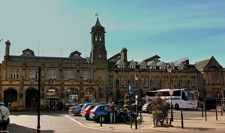
Carlisle City Centre: A Walk Around
Carlisle is the only city in Cumbria. Its city centre is mostly for walking, and The Lanes shopping centre has about 75 shops.
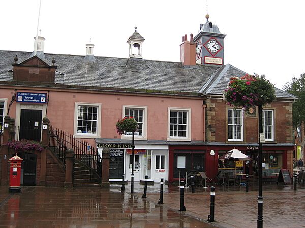
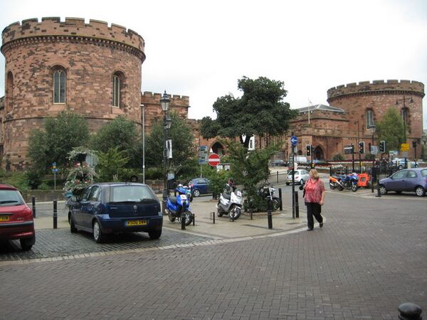
Carlisle has a compact historic centre. You can find a castle, a cathedral, and parts of the old city walls. Other old buildings include the Guildhall and Tithe Barn. The Citadel towers were designed by Thomas Telford. Next to the Citadel is Carlisle railway station, which is considered one of England's most important early railway stations.
City Centre Views
-
Old Town Hall built in 1668–69
-
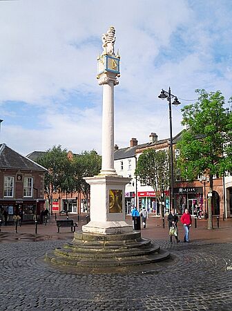
Carlisle Market Cross, 1682
-
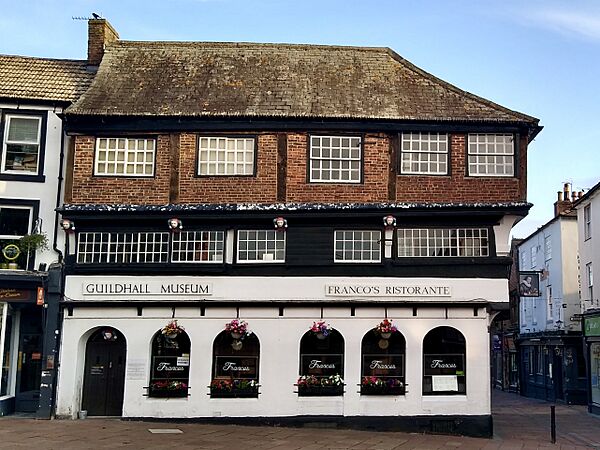
Guildhall Museum, 1407
-
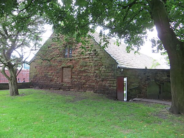
The Tithe Barn, 1470s
-
The Citadel, 1810
-
Carlisle Station frontage
-
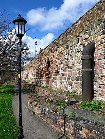
West City Walls
-
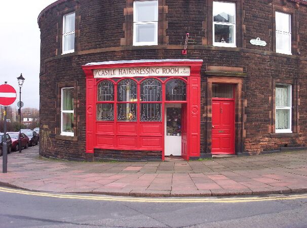
Traditional Barber Shop
-
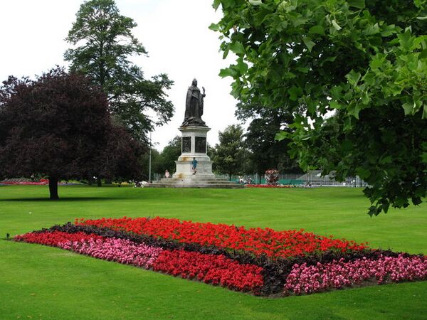
Bitts Park
-

Millennium Bridge
-
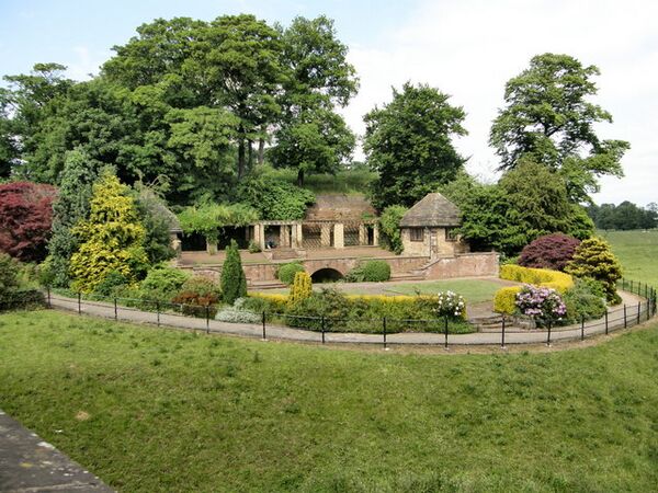
Chinese Gardens


.jpg)


How Carlisle is Governed
Local Government History

Carlisle has been a city since the Middle Ages. It has had a borough constituency (meaning it elected Members of Parliament) for centuries. In 1835, it became a municipal borough. Its boundaries have changed many times.
In 2001, Carlisle's population was 71,773. By 2011, it had grown to 75,306.
On April 1, 2023, the local government structure changed. The old Carlisle City Council was replaced by Cumberland Council. This new council is a unitary authority, meaning it handles both county and district council powers.
Parliamentary Representation
The current Member of Parliament for Carlisle is Julie Minns from the Labour Party.
Carlisle's Location and Weather
Geography of Carlisle
Carlisle is built on a small hill where the rivers Eden, Caldew, and Petteril meet.
It's an important trading spot. Carlisle is about 56 miles west of Newcastle upon Tyne, 71 miles north of Lancaster, and 90 miles south-east of Glasgow. It is also about 300 miles north-north-west of London.
 |
Lockerbie, Dumfries, Glasgow | Longtown, Langholm, Galashiels, Edinburgh | Jedburgh, Berwick-upon-Tweed | |
| Wigton, Belfast | Brampton, Hexham, Newcastle upon Tyne | |||
| Keswick, Workington, Whitehaven | Penrith, Kendal, Lancaster | Alston, York |
Carlisle's Climate
Carlisle has an oceanic climate, which means it has mild temperatures and rain throughout the year.
As mentioned, Carlisle has experienced severe flooding. In January 2005, strong winds and heavy rain caused the worst floods since 1822, leading to three deaths. Even worse flooding happened in December 2015, when nearly 36 hours of non-stop rain caused rivers to burst their banks. Many areas were underwater, and trains to Scotland were stopped. Prime Minister David Cameron visited the city to see the damage.
| Climate data for Carlisle WMO ID: 03220; coordinates 54°56′04″N 2°57′49″W / 54.93436°N 2.96364°W; elevation: 28 m (92 ft), 1991–2020 normals |
|||||||||||||
|---|---|---|---|---|---|---|---|---|---|---|---|---|---|
| Month | Jan | Feb | Mar | Apr | May | Jun | Jul | Aug | Sep | Oct | Nov | Dec | Year |
| Record high °C (°F) | 14.7 (58.5) |
16.0 (60.8) |
19.7 (67.5) |
25.2 (77.4) |
28.1 (82.6) |
30.4 (86.7) |
34.5 (94.1) |
33.2 (91.8) |
29.5 (85.1) |
23.5 (74.3) |
18.2 (64.8) |
15.3 (59.5) |
34.5 (94.1) |
| Mean maximum °C (°F) | 12.0 (53.6) |
12.0 (53.6) |
14.5 (58.1) |
18.4 (65.1) |
22.9 (73.2) |
24.8 (76.6) |
26.2 (79.2) |
24.6 (76.3) |
22.5 (72.5) |
18.3 (64.9) |
14.6 (58.3) |
12.5 (54.5) |
27.8 (82.0) |
| Mean daily maximum °C (°F) | 7.2 (45.0) |
7.8 (46.0) |
9.7 (49.5) |
12.5 (54.5) |
15.6 (60.1) |
18.1 (64.6) |
19.8 (67.6) |
19.3 (66.7) |
17.2 (63.0) |
13.6 (56.5) |
10.0 (50.0) |
7.4 (45.3) |
13.2 (55.8) |
| Daily mean °C (°F) | 4.6 (40.3) |
4.9 (40.8) |
6.4 (43.5) |
8.6 (47.5) |
11.1 (52.0) |
14.1 (57.4) |
15.9 (60.6) |
15.6 (60.1) |
13.5 (56.3) |
10.3 (50.5) |
7.1 (44.8) |
4.6 (40.3) |
9.7 (49.5) |
| Mean daily minimum °C (°F) | 1.9 (35.4) |
1.9 (35.4) |
3.0 (37.4) |
4.7 (40.5) |
7.1 (44.8) |
10.0 (50.0) |
11.9 (53.4) |
11.7 (53.1) |
9.8 (49.6) |
7.0 (44.6) |
4.1 (39.4) |
1.8 (35.2) |
6.3 (43.3) |
| Mean minimum °C (°F) | −4.3 (24.3) |
−3.9 (25.0) |
−2.9 (26.8) |
−1.2 (29.8) |
0.9 (33.6) |
4.8 (40.6) |
7.1 (44.8) |
6.0 (42.8) |
3.6 (38.5) |
−0.1 (31.8) |
−2.6 (27.3) |
−5.6 (21.9) |
−6.8 (19.8) |
| Record low °C (°F) | −13.5 (7.7) |
−14.9 (5.2) |
−10.7 (12.7) |
−4.8 (23.4) |
−1.6 (29.1) |
1.7 (35.1) |
3.4 (38.1) |
2.9 (37.2) |
0.6 (33.1) |
−4.1 (24.6) |
−9.2 (15.4) |
−14.7 (5.5) |
−14.9 (5.2) |
| Average precipitation mm (inches) | 81.3 (3.20) |
69.4 (2.73) |
62.3 (2.45) |
49.2 (1.94) |
57.4 (2.26) |
70.5 (2.78) |
80.6 (3.17) |
89.0 (3.50) |
77.8 (3.06) |
97.9 (3.85) |
85.3 (3.36) |
98.1 (3.86) |
918.8 (36.16) |
| Average precipitation days (≥ 1.0 mm) | 14.1 | 11.6 | 11.7 | 11.0 | 10.7 | 11.5 | 12.8 | 12.9 | 12.0 | 14.5 | 14.7 | 15.2 | 152.7 |
| Mean monthly sunshine hours | 53.6 | 74.8 | 108.5 | 156.9 | 197.5 | 181.0 | 165.6 | 163.2 | 126.9 | 90.3 | 59.3 | 43.4 | 1,421 |
| Average ultraviolet index | 0 | 1 | 2 | 3 | 5 | 6 | 6 | 5 | 3 | 2 | 1 | 0 | 3 |
| Source 1: Met Office Infoclimat | |||||||||||||
| Source 2: WeatherAtlas | |||||||||||||
Carlisle's Neighbourhoods

In the north of Carlisle, you'll find areas like Kingstown and Stanwix. South of Stanwix is the River Eden. On the other side is the city centre.
In the past, industries thrived along the River Caldew in areas like Denton Holme and Caldewgate. West of Caldewgate, new neighbourhoods like Newtown and Morton grew in the late 1800s and 1900s.
The east side of the city centre developed into a wealthier area. It connects to the former village of Botcherby, where a large housing estate was built.
South of the city centre are areas like Botchergate, Upperby, and Currock. Harraby is the largest suburb of Carlisle.
Transportation in Carlisle
Road Connections
Carlisle is well-connected by roads. The M6 motorway links it to the south of England, and the M74/A74 goes north towards Glasgow in Scotland. Other main roads starting or ending in Carlisle include the A6 to Penrith, the A595 to western Cumbria, the A69 to Newcastle, and the A7 to Edinburgh.
Train Travel

Carlisle became a major train hub. At one time, seven different companies used Carlisle Citadel railway station. Carlisle also had Kingmoor, one of Europe's largest railway marshalling yards, which is still used today.
Today, Carlisle railway station is an important stop on the West Coast Main Line. Other lines go to Newcastle, Leeds, and Glasgow. You can also take trains to west Cumbria and Barrow-in-Furness.
Bus Services
Most local bus services in Carlisle are run by Stagecoach Cumbria & North Lancashire.


The bus station is on Drury Lane. It has seven covered stands and a travel centre. It was built in the 1990s.
Air Travel
Carlisle Lake District Airport is a small airport about 5.8 miles east of the city. The closest major airport is Newcastle International Airport, about 55 miles away.
Carlisle's Businesses and Factories

In the 1800s and early 1900s, Carlisle became an industrial city. Many factories for textiles, engineering, and food opened in areas like Denton Holme.
Famous companies that started or had factories in Carlisle include Carr's of Carlisle (known for biscuits), Kangol, and Cowans Sheldon (a railway and marine engineering firm). Pirelli Carlisle opened in 1969.
The transport company Eddie Stobart Logistics used to have its main office in Carlisle.
Until 2004, Cavaghan & Gray was Carlisle's biggest employer, making chilled foods for supermarkets. One of its sites closed in 2005, leading to job losses.
Carlisle has various industrial estates and business parks on its edges. The largest is Kingstown Industrial Estate.
In 2005, Carlisle was given Fairtrade City status, meaning it supports fair trade practices.
Learning in Carlisle
Universities and Colleges
The University of Cumbria has four campuses in Carlisle. It offers many degree courses, including Information technology, Applied Psychology, Art, Business, Law, Media, Social Work, and Teacher Education.
Carlisle College is the main college for further education in the city.
Secondary Schools
Carlisle's secondary schools include Richard Rose Central Academy, Richard Rose Morton Academy, Austin Friars St Monicas (a private Catholic school), Trinity School, and St John Henry Newman Catholic School. Other secondary schools in the wider area are Caldew School in Dalston, William Howard School in Brampton, and Lime House School also in Dalston.
Richard Rose Central Academy opened in 2008. In 2009, there were protests about the school's quality, and its leaders were replaced.
Carlisle's Culture and Arts
Art and History Museums

The Tullie House Museum and Art Gallery opened in 1893. It has exhibits about the Roman history of the area, Hadrian's Wall, and the Border Reivers. Tullie House also hosts special traveling exhibitions. The museum has won many awards.
The city's Guildhall Museum is in a 14th-century house. The Border Regiment Military Museum is inside the castle.
Music and Theatre Scene
Carlisle's main entertainment place is the Sands Centre Sports Hall. It hosts touring musicians, theatre shows, and comedians. The West Walls Theatre is a local amateur theatre. The Old Fire Station, which opened in 2015, is a venue for bands, comedy, plays, and art. Brunton Park football stadium has also hosted concerts, like one by Elton John in 2007.
The Carlisle Music Festival happens every year at Carlisle Cathedral. Radio 1's Big Weekend, a large free music festival, was held at Carlisle Lake District Airport in 2011, with acts like Lady Gaga and the Foo Fighters.
Food and Local Produce
Every August, the Carlisle Food Fair takes place in the city centre. It features food from across Europe and local produce like Cumberland sausage, Cumberland sauce, Farmhouse Cheese, and Cumberland Mustard.
In 2012, Fair Food Carlisle won an award for its scheme that helps groups buy local food from businesses at a discount.
Media in Carlisle
From 1961 to 2009, Carlisle was home to Border Television, which served Cumbria and southern Scotland. Today, ITV Border's news and sales offices are in Carlisle, though its news program Lookaround is produced elsewhere.
For BBC One, the city is served by BBC Look North.
The Cumberland News is the local broadsheet newspaper published on Fridays. The News and Star is the evening paper. Both are published by a Carlisle-based company. Carlisle is also home to BBC Radio Cumbria and Greatest Hits Radio Cumbria & South West Scotland.
Sports in Carlisle
Football Teams
Association Football

Carlisle is represented in English football by Carlisle United. They currently play in the third tier of English football after being promoted in 2023. The club has played at Brunton Park since 1909.
Carlisle United joined the Football League in 1928. Their best achievement was reaching the top flight of English football in 1974. They even topped the league after winning their first three games that season, but were relegated after just one year. In 1999, Carlisle United avoided relegation from the Football League on the very last day of the season, when their goalkeeper Jimmy Glass scored a winning goal in injury time.
Many famous players have played for Carlisle United, including Peter Beardsley and Stan Bowles. Former managers include Bill Shankly and Paul Simpson.
Celtic Nation F.C. was a semi-professional club based in Carlisle, but it closed down in 2015 due to money problems.
Carlisle City is another semi-professional team that plays at Gillford Park.
Northbank Carlisle was a club that focused on youth football.
Rugby Teams
Carlisle has two rugby union clubs: Carlisle RFC and Creighton RUFC. Former England rugby union captain Steve Borthwick is from Carlisle.
The rugby league team, Carlisle, merged with another team and left Carlisle.
American Football
The Carlisle Border Reivers were an American football team that later rebranded as the Carlisle Kestrels. They play at Gillford Park.
Racing Sports
Carlisle Racecourse was set up in 1904 and is now a top-class horse racing track. Horse racing has been happening in Carlisle for centuries.
There were also three greyhound racing tracks in Carlisle in the late 1920s.
Other Sports
Carlisle Cricket Club plays at the Edenside Ground.
Carlisle has several golf clubs, including Stoneyholme and Carlisle Golf Club.
In 2012, Carlisle was a stop for the Olympic torch on its way to the Olympic Games in London.
Carlisle's Military Connections

Carlisle has been a military city for over 1,500 years. It is the most besieged place in the British Isles, having been attacked at least ten times. It has had soldiers stationed there for most of its history.
Cumbria's county regiment, the Border Regiment, had its headquarters at Carlisle Castle. This regiment later became part of the Duke of Lancaster's Regiment. From 1720 to 1959, the regiment fought in many wars, including the French and Indian War and the First World War.
RAF Carlisle
RAF Carlisle, also known as 14 MU, was an air force base near the present-day Asda. It closed in 1996 after almost 60 years. It started as a bomber station in 1938, then became a training school, and later a storage facility.
RAF Spadeadam
RAF Spadeadam is the largest RAF station by area in the country. It is an electronic warfare training range. It is located outside Carlisle but has strong ties to the local community. In 2018, it was given the Freedom of the City of Carlisle.
Carlisle's Legends and Folklore
- Legend and Folklore
-
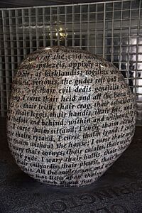
The Cursing Stone

Arthurian Legends
There are many old stories about Carlisle from the Dark Ages. One is about Sir Gawain and the Carle of Carlisle, featuring King Arthur's nephew and a "free man" of the city.
In a 14th-century poem, Sir Gawain, a Knight of the Round Table, stayed at Carlisle Castle during a hunting trip. This story is similar to another famous poem, Sir Gawain and the Green Knight.
Some people even believe that Carlisle is actually Camelot, the legendary home of King Arthur's court!
The Curse of Carlisle
In local folklore, the Curse of Carlisle is a 16th-century curse. It was supposedly put on the Border Reivers by Archbishop Dunbar of Glasgow in 1525 because they were stealing cattle.
For the millennium celebrations, the city council put up a 14-tonne granite stone with all 1,069 words of the curse carved into it. After the stone was put up, Carlisle suffered floods, animal diseases, job losses, and the local football team had trouble scoring goals. Some people thought the curse was real! The city council even thought about removing the stone. However, a "white witch" named Kevin Carlyon said that removing it would make the curse stronger. He believed the curse only works if people believe in it.
Carlisle's International Connections
Twin Towns
Carlisle is twinned with:
- Flensburg, Schleswig-Holstein, Germany
- Słupsk, Pomeranian Voivodeship, Poland
See also
 In Spanish: Carlisle para niños
