
Croydon facts for kids
Quick facts for kids Croydon |
|
|---|---|
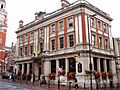
    Clockwise from top: the Old Town Hall and Clocktower (with the Spreadeagle in the foreground), Katharine Street; No. 1 Croydon building; the Grants Building, High Street; Saffron Square and other blocks
|
|

Croydon
|
|
| Population | 192,064 (2011 census) |
| OS grid reference | TQ335655 |
| • Charing Cross | 9.3 mi (15.0 km) N |
| London borough | |
| Ceremonial county | Greater London |
| Region | |
| Country | England |
| Sovereign state | United Kingdom |
| Post town | CROYDON |
| Postcode district | CR0 |
| Dialling code | 020 01689 (Addington and New Addington parts) |
| Police | Metropolitan |
| Fire | London |
| Ambulance | London |
| EU Parliament | London |
| UK Parliament |
|
| London Assembly |
|
Croydon is a large town in South London, England. It is about 15 kilometres (9 miles) south of Charing Cross, a famous spot in central London. Croydon is part of the London Borough of Croydon, which is a local government area within Greater London.
This town is one of the biggest business areas in Greater London. It has a huge shopping district. In 2011, the town of Croydon had about 192,064 people living there. The whole borough had a population of 384,837.
Long ago, Croydon was a small village in Surrey. The Domesday Book from 1086 shows it had a church, a mill, and about 365 people. Croydon grew a lot in the Middle Ages. It became a busy market town and was known for making charcoal, tanning leather, and brewing beer.
In 1803, the Surrey Iron Railway opened, connecting Croydon to Wandsworth. This was one of the first public railways! Later, in the 1800s, more railways helped Croydon grow as a place where people lived and traveled to London for work.
By the early 1900s, Croydon was an important industrial area. It was known for making cars, working with metal, and for Croydon Airport. In the mid-1900s, these industries changed. Shopping and service jobs became more important. This happened because of big building projects, like new office blocks and the Whitgift Centre. The Whitgift Centre was the largest shopping centre in Greater London until 2008.
Croydon used to be part of the county of Surrey. From 1889 to 1965, it was a special area called a county borough. But in 1965, it became part of Greater London.
Croydon is on a major route between central London and England's south coast. It sits north of two gaps in the North Downs hills. These gaps are used by main roads and railway lines. The town centre is mostly for walking, with traffic routed around it. East Croydon railway station is a very busy train hub. It has fast trains to central London, Brighton, and the south coast. Croydon also has the only tram system in Southern England.
Contents
History of Croydon
What's in a Name?
Most experts believe the name Croydon comes from old Anglo-Saxon words. Croh meant "crocus" and denu meant "valley". This suggests that, like Saffron Walden, Croydon was a place where saffron crocuses were grown. People think this happened during the Roman times. Saffron was probably grown to sell in London, perhaps for medicine.
Another idea is that the name comes from an old British word, "Crai-din." This means "settlement near fresh water."
Early Days of Croydon
Croydon is located on an old Roman road that went from London to Portslade. There's some proof that Romans had a small settlement here. Later, between the 400s and 600s, a large pagan cemetery was found where Park Lane is now.
By the late Saxon period, Croydon was owned by the Archbishops of Canterbury. The church and the archbishops' manor house were in the area now called "Old Town." The archbishops lived in the manor house sometimes. They were important leaders in the town for a long time.

The church was built in the middle Saxon period. It was likely a "minster church," a place where a group of priests lived together. The church is also mentioned in the Domesday Book from 1086.
In 1276, Archbishop Robert Kilwardby got permission to hold a weekly market. This was probably when Croydon really started to become a town. The market was set up on higher ground east of the manor house. This area is now bordered by High Street, Surrey Street, and Crown Hill.
By the 1500s, the manor house had become a large palace. It was the archbishops' main summer home. Kings and other important people visited it. But the palace slowly fell apart and was surrounded by poor areas. In 1781, the archbishops sold it and bought a new home nearby in Addington. Many parts of the original Croydon Palace still stand and are used today as Old Palace School.

The Parish Church (now Croydon Minster) is a Gothic-style church. It was rebuilt in 1849 but was destroyed in a big fire in 1867. Only the tower, south porch, and outer walls were left. A new church was designed by Sir George Gilbert Scott, a famous architect from the Victorian era. It opened in 1870. The new design looked similar to the old one. Six Archbishops of Canterbury are buried here.

The old Whitgift Almshouses, also called the "Hospital of the Holy Trinity," are in the centre of Croydon. Archbishop John Whitgift built them. The first stone was laid in 1596, and the building was finished in 1599. The Almshouses provided homes for 28 to 40 people. There was also a schoolhouse and a schoolmaster's house. The building has a courtyard surrounded by rooms.
These Almshouses were almost torn down for new building plans. But in 1923, the House of Lords saved them. In 1983, Queen Elizabeth II visited and unveiled a plaque. Every year on March 22, people celebrate Founder's Day.
Croydon's Growth and the Railway

In the late 1700s, Brighton became a popular holiday spot. This made Croydon an important stop for stage coaches traveling south from London. In the early 1800s, Croydon became the end point for two new ways to transport goods to London.
The first was the horse-drawn Surrey Iron Railway, which opened in 1803. It went from Wandsworth to Croydon. The second was the Croydon Canal, which opened in 1809. It connected to the Grand Surrey Canal at Deptford.
The London and Croydon Railway opened in 1839. It used steam power and followed much of the old canal route. More railway lines to London and the south followed. The arrival of railways in the 1800s caused Croydon's population to grow 23 times bigger between 1801 and 1901!
This fast growth led to health problems, especially in the crowded Old Town area. So, in 1849, Croydon was one of the first towns to get a local board of health. This board built important public health systems like a reservoir, water supply network, sewers, and a pumping station.
Modern Croydon Takes Shape

In 1883, Croydon officially became a borough. In 1889, it became a county borough, which gave it more control over its own affairs. The new council improved the town in the early 1890s. They made the High Street wider and cleared out many poor areas. After World War II, the remaining poor areas were cleared. Many people moved to a new settlement called New Addington.
New shops opened and grew in central Croydon, including Allders and Grants. The first Sainsbury's self-service shop in the country also opened here. The Surrey Street Market continued to be a busy place.
Croydon was home to London's main airport until World War II. During the war, parts of central Croydon were badly damaged by German V-1 flying bombs and V-2 rockets. For many years, you could see the damage. After the war, Heathrow Airport became London's main airport. Croydon Airport closed in 1959.
By the 1950s, Croydon was getting very busy with traffic. The council decided on another big redevelopment plan. This led to many new office blocks, an underpass, a flyover, and multi-storey car parks being built in the late 1950s and 1960s. Croydon became a booming business centre.
.jpg)
The town kept growing and attracting new buildings. The Fairfield Halls arts centre opened in 1962. Croydon became an important shopping hub with the Whitgift Centre opening in 1969. No. 1 Croydon (also known as the NLA Tower) was finished in 1970.
The 1990s brought more changes to make the town look nicer. North End was closed to vehicles in 1989, making it a pedestrian shopping street. The Croydon Clocktower arts centre opened in 1994.
The Croydon Tramlink system started running in May 2000.

Another large shopping centre, Centrale, opened in 2004 across from the Whitgift Centre. There are also plans for a huge new shopping centre, a Westfield mall. In 2017, Croydon Council approved the new Westfield centre. The Mayor of London also approved it in 2018. Work was supposed to start in 2018, but it has been delayed.
Croydon has many tall buildings, like the former Nestlé Tower (St George's House). This building, which Nestlé used until 2012, is being turned into 288 flats. Many new apartment buildings have been built or are planned. Saffron Square, which includes a 43-storey tower, was finished in 2016. Other towers over 50 floors high have been approved.
In 2012, Croydon was chosen as one of twelve "Portas Pilot" towns. This means it received funding to help improve its central shopping areas.

In 2016, a Boxpark made of sea containers opened at Ruskin Square. This is a temporary spot for shops, offices, and homes until new buildings are ready. This and other projects are helping to make the town more modern and appealing.
What's Next for Croydon?
A "Croydon Vision 2020" plan was created to guide the town's future. It includes new office blocks, apartment buildings, shopping centres, and other developments. More than 2,000 new homes are planned.
The Fairfield Halls are planned to be the heart of a new cultural area. This area will include an art gallery, a new college, shops, and offices.
Croydon's Economy
Croydon is a major shopping destination. In 2011, its annual retail sales were £353 million. This was the fifth highest in Greater London. In 2012, Croydon had the second largest amount of shopping space in Greater London, after the West End.
Besides its big central shopping area, Croydon has smaller shopping spots. Many restaurants are found towards the southern end of the town.
Public Services
The police force in Croydon is the Metropolitan Police. Their police station is on Park Lane.
The London Fire Brigade provides fire and rescue services. They have a fire station in Old Town.
The closest hospital is Croydon University Hospital. It is in nearby Thornton Heath. The London Ambulance Service provides ambulance services.
People and Population
Croydon is a very diverse town, with people from many different backgrounds. For example, the West Thornton area is one of the most ethnically diverse places in England.
The Fairfield area, which covers the town centre, had a population that was 40% White British, 16% Indian, and 10% Other White in 2011. Most people were Christian (46%), followed by those with no religion (21%), Hindu (13%), and Muslim (8%).
Geography of Croydon


Croydon town centre is in the middle of the borough of Croydon. It's north of the North Downs hills. To the north of Croydon are typical London areas. But a short distance southeast, like in Coombe and Selsdon, you'll find green, hilly, and rural land.
Croydon High Street runs from South Croydon to North End. North End is the main shopping street. Croydon High Street is where you'll find most of the restaurants.
The High Street is also home to Wrencote House. This is a very old building from the late 1600s or early 1700s. It was probably built as a merchant's house.
Wellesley Road is a main road that goes north-south through the town centre. There are plans to make it easier for people to cross this road and connect East Croydon station better with the town centre.
Croydon generally sits between 50 metres (in the north) and 70 metres (in the south) above sea level. The land gets much higher to the east of the town. The highest point in Croydon is the Sanderstead Plantation, which is over 175 metres high.
River Wandle
The River Wandle is a river that flows into the River Thames. It flows about 14 kilometres (9 miles) from its source in Croydon to Wandsworth and Putney. It forms part of the border between Croydon and the London Borough of Sutton.
Culture in Croydon
Arts and Entertainment

Croydon has several places for arts and entertainment. The most important is the Fairfield Halls, which opened in 1962. It has a large concert hall, the Ashcroft Theatre, and the Arnhem Gallery. The London Mozart Players perform here often. Many famous artists have appeared at Fairfield Halls, including the Beatles, Jimi Hendrix, David Bowie, and Queen. The main concert hall was even used in the movie The Da Vinci Code. The Fairfield Halls reopened in 2019 after being updated.

The Croydon Clocktower was developed in the mid-1990s. It has a modern library, a performance space, the David Lean Cinema (a small, independent movie theatre), and the Museum of Croydon. The museum tells the story of Croydon's history. The building connects to Croydon Town Hall. A bronze statue of Queen Victoria stands outside the buildings.
The Warehouse Theatre (which closed in 2012) was known for showing new plays, comedy, and youth theatre. It closed because of a big redevelopment project. It plans to reopen in a new, larger theatre building in the future.
The Spread Eagle Theatre is a new 50-seat theatre that opened in 2013. It focuses on new plays and supporting new artists.
Public Art

About 60 murals were added to Croydon town centre in 2018. This was part of the Rise street art festival.
Literature and Croydon
Croydon is mentioned in poems by the famous British poet John Betjeman. Many well-known authors have lived in the area, including Arthur Conan Doyle, who created Sherlock Holmes, and D.H. Lawrence. Cicely Mary Barker, who wrote the Flower Fairies books, was born in Croydon.
Croydon is also the setting for novels. The old airport was featured in mysteries like The 12.30 from Croydon. The town is also mentioned in some Sherlock Holmes stories.
In Jane Austen's unfinished novel The Watsons, a character says, "there is always something lively going on at Croydon."
Music Scene
The composer Samuel Coleridge-Taylor (1875–1912) lived in Selhurst, Croydon, until he passed away. He grew up in Croydon and sang in the church choir.
Addington Palace was home to The Royal School of Church Music from 1953 to 1996.
Besides the Fairfield Halls, many other places in Croydon have hosted rock bands. The Greyhound in Park Lane had acts like Led Zeppelin, Jimi Hendrix, The Who, and David Bowie in the 1960s and 70s.
Croydon has been important in the development of dubstep music. Artists like Benga and Skream learned their skills while working at Big Apple Records on Surrey Street. UK rappers and grime artists like Stormzy also come from Croydon.
The BRIT School for performing arts and technology is in Selhurst, Croydon. It has produced many famous stars, including Adele, Jessie J, and Amy Winehouse.
Sport and Outdoors
Parks and Green Spaces

Croydon has many woods for walking, which make up a large part of Greater London's woodland. These include Lloyd Park and Croham Hurst.
In the town centre, there's a green space called Queens Gardens. It's next to the town hall and Clocktower arts centre.
One of the sources of the River Wandle is in Croydon. This river is a rare "chalk stream." The Wandle Trail allows people to walk off-road to London.
Sports Clubs and Teams
The most famous sports club in the borough is Crystal Palace Football Club. They have been based in the north of the borough since 1918. Palace plays at their stadium, Selhurst Park. They were promoted to the Premier League (England's top football league) at the end of the 2012–13 season.
Streatham-Croydon RFC, founded in 1871, is one of Greater London's oldest rugby union clubs. They play just north of the town centre.
There are also several field hockey clubs in and around Croydon.
Transport in Croydon


Train Travel
Croydon has three main train stations: East Croydon, South Croydon, and West Croydon. East Croydon and South Croydon have trains run by Govia Thameslink Railway (Southern and Thameslink). West Croydon has London Overground and Southern services. East Croydon is the biggest and busiest station.
Tram System

The Tramlink tram system opened in 2000, and Croydon is its main hub. Trams run from places like Elmers End or Beckenham to Wimbledon, and from New Addington to West Croydon. All trams go through a loop in central Croydon. It's the only tram system in Greater London.
Roads and Buses
A few miles south of Croydon, there's a small gap in the North Downs hills. This route is used for transport from London to the south coast. The main road to Brighton used to go through the town centre. Now, the A23 Purley Way goes to the west.
Transport for London runs many bus routes in and around Croydon. Most buses stop at West Croydon bus station.
Croydon's Early Transport
The horse-drawn Surrey Iron Railway was one of the first public railways. It opened in 1803 and ran from Wandsworth to Croydon. It closed in 1846 when faster steam trains arrived. Parts of its route are now used by the modern Tramlink.
The Croydon Canal opened in 1809. It ran for about 15 kilometres (9.5 miles) from what is now West Croydon station. It was not very successful and was sold in 1836. The lake at South Norwood used to be a reservoir for the canal.
Croydon Airport on Purley Way was London's main airport until it was replaced by Heathrow Airport and Gatwick Airport. It opened in 1920. It became one of the world's great airports in the 1920s and 1930s. Many famous early aviators visited it. But by 1952, it was clear the airport was too small for growing air traffic. It closed in 1959. The old air terminal, now called Airport House, has been restored and has a museum.
Famous People from Croydon


Many well-known people have connections to Croydon:
- Peggy Ashcroft (1907–1991), a famous actress, was born in Croydon.
- Raymond Chandler (1888–1959), an American detective writer, lived in Upper Norwood as a boy.
- Kit Connor (2004–), an actor known for Heartstopper, was born and grew up in Croydon.
- Sir Arthur Conan Doyle (1859–1930), the Scottish writer who created Sherlock Holmes, lived in South Norwood.
- Roy Hodgson (1947–), a football manager for Crystal Palace F.C. and former England manager, was born and grew up in Croydon.
- Tom Holland (1996–), an actor in Marvel Cinematic Universe films, went to the BRIT School.
- D. H. Lawrence (1885–1930), a famous novelist, lived in Addiscombe while he was a teacher.
- David Lean (1908–1991), a famous film director, was born in Croydon.
- Kirsty MacColl (1959–2000), a singer and songwriter, grew up in Selsdon, Croydon.
- Ralph McTell (1944–), a musician known for "Streets of London", grew up in Croydon.
- Katie Melua (1984–), a musician and singer, attended the BRIT School.
- Kate Moss (1974–), a supermodel, went to school in Croydon.
- Stormzy (1993–), a UK grime rapper, was born in Croydon.
- Amy Winehouse (1983–2011), a famous singer, attended the BRIT School.
- Wilfried Zaha (1992–), a professional football player, grew up in Thornton Heath.
Education in Croydon

The town is home to Croydon College. Its main buildings are near East Croydon station. It has over 13,000 students. The college offers university-level courses and training opportunities.
Croydon has several private schools. Three of them are part of the Whitgift Foundation. Whitgift School and Trinity School of John Whitgift are boys' schools. Old Palace School is an independent girls' school located in the old Summer Palace of the Archbishops of Canterbury.
Croydon High School is an independent girls' school in Selsdon. Royal Russell School is a co-educational independent school in South Croydon.
There are also several Catholic state schools. The John Fisher School in Purley is a boys' school. Coloma Convent Girls' School is a Catholic girls' school. St Joseph's College in Upper Norwood is a boys' school with a mixed sixth form. Thomas More is a Catholic mixed school.
Images for kids
-
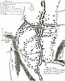
The earliest detailed map of Croydon, drawn in 1785.
-
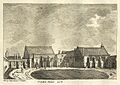
Croydon Palace in 1785
-
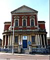
The West Croydon Baptist Church
-
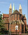
The Parish Church of St Michael and All Angels, West Croydon
-
Shopping parade in North End, Croydon
-
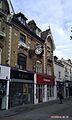
Victorian architecture in Croydon High Street
-
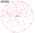
A map showing a 15-mile radius from Croydon
-
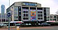
The Fairfield Halls, Croydon's entertainment complex
-
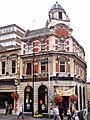
The Spreadeagle, central Croydon, which also houses a theatre
-
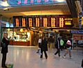
The concourse of East Croydon station
-
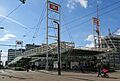
East Croydon mainline station


.jpg)

.jpg)
