Hidden Hills, California facts for kids
Quick facts for kids
Hidden Hills, California
|
||
|---|---|---|

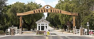
Gate to Hidden Hills
|
||
|
||

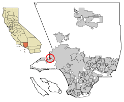
Location of Hidden Hills in Los Angeles County, California
|
||
| Country | United States | |
| State | California | |
| County | Los Angeles | |
| Incorporated | October 19, 1961 | |
| Area | ||
| • Total | 1.69 sq mi (4.38 km2) | |
| • Land | 1.69 sq mi (4.38 km2) | |
| • Water | 0.00 sq mi (0.00 km2) | |
| Population
(2020)
|
||
| • Total | 1,725 | |
| • Density | 1,021/sq mi (393.8/km2) | |
| Time zone | Pacific | |
| • Summer (DST) | PDT | |
| ZIP code |
91302
|
|
| Area codes | 818 | |
| FIPS code | 06-33518 | |
Hidden Hills is a city in Los Angeles County, California. It is a special kind of community called a gated community. This means it has controlled entrances and is often surrounded by fences or walls. Hidden Hills is located near the Santa Monica Mountains. It sits right next to the cities of Los Angeles and Calabasas. In 2020, about 1,725 people lived there.
Contents
History of Hidden Hills
The very first people to live in this area were the Chumash people. They were Native Americans who lived in California for thousands of years.
Hidden Hills was planned and built in the 1950s. A landscape architect named A. E. Hanson designed the community. He was known for creating other planned communities in Southern California. Some of his earlier projects included Rolling Hills and Palos Verdes Estates.
In 2017, Vanity Fair magazine described Hidden Hills. They said it has no sidewalks or streetlights. You can see many signs that say "Horses & children at play." The homes often sit on large plots of land, about 2 acres each. These plots are usually surrounded by white three-rail fences. The magazine said this gives Hidden Hills a "rough-around-the-edges charm."
Hidden Hills was first meant to be a quiet, "rustic retreat" away from the busy city of Los Angeles. Today, it is known as a fancy and popular place for many famous people.
Geography and Location
Hidden Hills is a gated neighborhood. It covers a total area of about 1.69 square miles (4.38 square kilometers). All of this area is land.
The city is located in the southern part of the Simi Hills. These hills are part of a larger mountain range called the Transverse Ranges. Hidden Hills is on the western edge of the San Fernando Valley. It is also close to the border of Ventura County.
To the north of Hidden Hills, you'll find the Upper Las Virgenes Canyon Open Space Preserve. This is a large nature reserve and greenbelt. It has many miles of trails for horseback riding, hiking, and mountain biking. South of the city is the historic Leonis Adobe National Historic Landmark. This site has gardens and a museum about the past. The city is also just north of U.S. Route 101, which is also known as the Ventura Freeway.
Climate in Hidden Hills
| Climate data for Hidden Hills, California | |||||||||||||
|---|---|---|---|---|---|---|---|---|---|---|---|---|---|
| Month | Jan | Feb | Mar | Apr | May | Jun | Jul | Aug | Sep | Oct | Nov | Dec | Year |
| Mean daily maximum °F (°C) | 66 (19) |
68 (20) |
70 (21) |
75 (24) |
79 (26) |
85 (29) |
92 (33) |
93 (34) |
89 (32) |
82 (28) |
73 (23) |
67 (19) |
78 (26) |
| Mean daily minimum °F (°C) | 42 (6) |
43 (6) |
44 (7) |
46 (8) |
50 (10) |
54 (12) |
57 (14) |
58 (14) |
56 (13) |
51 (11) |
44 (7) |
41 (5) |
49 (9) |
| Average precipitation inches (mm) | 5.59 (142) |
5.56 (141) |
4.69 (119) |
1.12 (28) |
0.31 (7.9) |
0.07 (1.8) |
0.02 (0.51) |
0.16 (4.1) |
0.29 (7.4) |
0.63 (16) |
1.89 (48) |
3.12 (79) |
23.45 (596) |
People Living in Hidden Hills (Demographics)
In 2020, the 2020 United States Census counted 1,725 people living in Hidden Hills. Most residents were white. There were also people of Asian, Black or African American, and other backgrounds. Some residents identified as being of two or more races. About 6.8% of the population was Hispanic or Latino.
There were 635 homes in Hidden Hills. Most of these homes were lived in by their owners. Only a small number were rented out.
According to a project called Mapping L.A., in 2000, the most common family backgrounds were Russian and English. Many people living in Hidden Hills were born in other countries, especially Mexico and Canada.
Arts and Community Culture
Hidden Hills has many fun activities for its residents. There is a summer camp for kids. The community also has theater programs for both children and adults. Throughout the year, there are annual parades, carnivals, and parties. During the summer, the city hosts weekly community barbecues. They even have "snow days," which are special events where snow is brought in for fun, since it rarely snows there naturally.
Education in Hidden Hills
The city has one public school called Round Meadow Elementary. In 2013, this school scored 902 on the Academic Performance Index. This index measures how well schools are doing.
City Services and Infrastructure
The Los Angeles County Sheriff's Department (LASD) helps keep Hidden Hills safe. They operate from the Malibu/Lost Hills Station in Calabasas.
The Los Angeles County Fire Department (LACoFD) provides fire services for the city.
Famous People Who Live or Lived in Hidden Hills
- Pepe Aguilar, singer, actor, and producer
- Marc Anthony, singer
- Frankie Avalon, musician
- Iggy Azalea, rapper
- Ashlee Bond (born 1985), American-Israeli Olympic show jumping rider
- Edgar Buchanan, actor
- Tyson Chandler, professional basketball player
- Eddie Cibrian, actor
- Kaley Cuoco, actress
- Miley Cyrus, singer-songwriter
- DeMar DeRozan, basketball player
- Scott Disick, television personality
- Drake, rapper
- Don Drysdale (1936–1993), Los Angeles Dodgers pitcher
- Jeff Dunham, comedian and ventriloquist
- Kevin Durant, NBA player for the Phoenix Suns
- Elliot Easton, musician (The Cars)
- Melissa Etheridge, musician
- Scott Foley, actor
- Jamie Foxx, actor
- Daisy Fuentes, TV personality and host
- Paul George, professional basketball player
- Jared Goff, NFL quarterback
- Selena Gomez, actress, singer
- Taylor Hawkins (1972-2022), drummer for Foo Fighters
- Robert Herjavec, businessman
- Olivia Jade, YouTuber
- Caitlyn Jenner, Olympic athlete
- Kendall Jenner, model, television personality
- Kris Jenner, television personality
- Khloé Kardashian, television personality
- Kim Kardashian, television personality
- Rob Kardashian, television personality
- Chuck Liddell, martial artist
- Diana Jenkins, entrepreneur and philanthropist
- Lori Loughlin, actress
- Leona Lewis, singer-songwriter and activist
- Jennifer Lopez, singer, actress, and entrepreneur
- Madonna, singer/actress
- Howie Mandel, comedian, TV host
- Richard Marx, singer-songwriter, producer
- Marie McDonald, actress, singer
- Sean McVay, NFL coach
- Nicki Minaj, rapper
- French Montana, rapper
- Shay Mitchell, actress
- Ozzy Osbourne, musician
- Sharon Osbourne, television personality, host
- Russell Peters, comedian
- Trevor Plouffe, Major League Baseball (MLB) player
- Jeff Porcaro, musician, member of Toto
- Jalen Ramsey, football player
- Denise Richards, actress and model
- LeAnn Rimes, singer-songwriter, and producer
- Josh Satin, major league baseball player
- Vin Scully (1927–2022), sportscaster
- Nicolette Sheridan, actress
- Shroud, online streamer
- Ben Simmons, basketball player
- Jessica Simpson, singer
- Sinbad, stand-up comedian, actor
- Will Smith, rapper, actor
- Jada Pinkett-Smith, actress, singer
- Jaden Smith, rapper, singer, songwriter, actor
- Britney Spears, pop singer
- Matthew Stafford, NFL player
- John Stamos, actor and musician
- Sylvester Stallone, actor
- Jeffree Star, makeup artist
- Gabrielle Union, actress
- Alex Van Halen, musician
- Dwyane Wade, basketball player
- The Weeknd, musician
- Kanye West, rapper and producer
- Lil Wayne, rapper
See also
 In Spanish: Hidden Hills para niños


