
Northampton County, Pennsylvania facts for kids
Quick facts for kids
Northampton County
|
|||
|---|---|---|---|

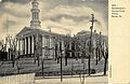
A 1905 illustration of Northampton County Courthouse in Easton
|
|||
|
|||

Location within the U.S. state of Pennsylvania
|
|||
 Pennsylvania's location within the U.S. |
|||
| Country | |||
| State | |||
| Founded | March 11, 1752 | ||
| Named for | Northamptonshire, England | ||
| Seat | Easton | ||
| Largest city | Bethlehem | ||
| Area | |||
| • Total | 377 sq mi (980 km2) | ||
| • Land | 370 sq mi (1,000 km2) | ||
| • Water | 7.7 sq mi (20 km2) 2.0%% | ||
| Population
(2020)
|
|||
| • Total | 312,951 | ||
| • Density | 830/sq mi (320/km2) | ||
| Time zone | UTC−5 (Eastern) | ||
| • Summer (DST) | UTC−4 (EDT) | ||
| Congressional district | 7th | ||


Northampton County is a county in the state of Pennsylvania, United States. In 2020, about 312,951 people lived here. The main town, or county seat, is Easton.
The county was created in 1752. It was formed from parts of Bucks County. It was named after Northamptonshire in England. The town of Easton was named after Easton Neston, a large house in Northamptonshire.
Northampton County and Lehigh County are next to each other. Together, they form a region called the Lehigh Valley. Lehigh County has more people than Northampton County. Both counties are part of the Philadelphia media market. This is the fourth-largest media market in the United States.
Northampton County has a history of making many things. It was a leader in producing cement and steel. The Atlas Portland Cement Company was once the world's largest cement maker. It was located in Northampton in this county. Bethlehem Steel was the world's second-largest steel maker. It was based in Bethlehem, the county's biggest city.
Northampton County is surrounded by other places. To the north are Carbon County and the Poconos. To the west is Lehigh County. To the south is Bucks County. To the east are the Delaware River and New Jersey. The Lehigh River flows through the county. It is about 109 miles (175 km) long.
Contents
Geography

Northampton County covers about 377 square miles (976 km²). Most of this area, 370 square miles (958 km²), is land. The rest, about 7.7 square miles (20 km²), is water.
The climate here is mostly humid continental. This means it has warm summers and cold winters. In Bethlehem, the average temperature in January is about 29.1°F (-1.6°C). In July, it's about 74.1°F (23.4°C).
Neighboring Counties
Northampton County shares borders with these counties:
- Monroe County (north)
- Warren County, New Jersey (east)
- Bucks County (south)
- Lehigh County (west)
- Carbon County (northwest)
Protected Natural Areas
Parts of these national protected areas are in Northampton County:
Population Facts
| Historical population | |||
|---|---|---|---|
| Census | Pop. | %± | |
| 1790 | 24,220 | — | |
| 1800 | 30,062 | 24.1% | |
| 1810 | 38,145 | 26.9% | |
| 1820 | 31,765 | −16.7% | |
| 1830 | 39,482 | 24.3% | |
| 1840 | 40,996 | 3.8% | |
| 1850 | 40,235 | −1.9% | |
| 1860 | 47,904 | 19.1% | |
| 1870 | 61,432 | 28.2% | |
| 1880 | 70,312 | 14.5% | |
| 1890 | 84,220 | 19.8% | |
| 1900 | 99,687 | 18.4% | |
| 1910 | 127,667 | 28.1% | |
| 1920 | 153,506 | 20.2% | |
| 1930 | 169,304 | 10.3% | |
| 1940 | 168,959 | −0.2% | |
| 1950 | 185,243 | 9.6% | |
| 1960 | 201,412 | 8.7% | |
| 1970 | 214,368 | 6.4% | |
| 1980 | 225,418 | 5.2% | |
| 1990 | 247,105 | 9.6% | |
| 2000 | 267,066 | 8.1% | |
| 2010 | 297,735 | 11.5% | |
| 2020 | 312,951 | 5.1% | |
| U.S. Decennial Census 1790-1960 1900-1990 1990-2000 2010-2019 |
|||
In 2020, the population of Northampton County was 312,951. This was a 5.1% increase from 2010.
In 2020, about 73% of the people were White. About 5.6% were Black or African American. About 3.2% were Asian. People of Hispanic or Latino background made up about 14.25% of the population.
Education

Northampton County has several colleges and universities:
- Lafayette College in Easton
- Lehigh University in Bethlehem
- Moravian University in Bethlehem
- Northampton County Area Community College in Bethlehem Township
- Respect Graduate School in Bethlehem
Public Schools
.jpg)
Many public school districts serve the county:
- Bangor Area School District
- Bethlehem Area School District
- Catasauqua Area School District
- Easton Area School District
- Nazareth Area School District
- Northampton Area School District
- Pen Argyl Area School District
- Saucon Valley School District
- Wilson Area School District
There is also a public charter school:
- Lehigh Valley Charter High School for the Arts in Bethlehem
Private High Schools
- Bethlehem Catholic High School in Bethlehem
- Moravian Academy in Bethlehem
- Notre Dame High School in Easton
Transportation
.JPG)
Air Travel
You can fly to and from Northampton County through Lehigh Valley International Airport. This airport is about 4 miles (6.4 km) northwest of Bethlehem. It is also about 11 miles (18 km) west-southwest of Easton.
Bus Service
Public bus service is provided by LANta. There is also a special shuttle bus in Bethlehem called the Bethlehem Loop. NJ Transit offers bus service from Easton to the Phillipsburg area in New Jersey.
Main Roads

Several major highways run through Northampton County:
 I-78
I-78 US 22
US 22 PA 33
PA 33 PA 145
 PA 191
 PA 248
 PA 329
 PA 378
 PA 412
 PA 512
 PA 611
 PA 946
 PA 987
Telecommunications
Northampton County uses several area codes for phone numbers. It was first served by area code 215. Later, in 1994, area code 610 was added. In 1999, area code 484 was also added. Most of Northampton County uses 610 and 484. The Portland area uses area code 570.
Fun Activities and Parks
Northampton County has two Pennsylvania state parks:
- Delaware Canal State Park: This park follows the old Delaware Canal. It runs along the Delaware River from Easton to Bristol.
- Jacobsburg Environmental Education Center: This center offers programs to learn about nature and the environment.
Cities, Towns, and Communities


Northampton County has different types of communities:
Cities
- Bethlehem (partly in Lehigh County)
- Easton (the county seat)
Boroughs
Townships
- Allen
- Bethlehem
- Bushkill
- East Allen
- Forks
- Hanover
- Lehigh
- Lower Mount Bethel
- Lower Nazareth
- Lower Saucon
- Moore
- Palmer
- Plainfield
- Upper Mount Bethel
- Upper Nazareth
- Washington
- Williams
Census-Designated Places (CDPs)
These are areas the U.S. Census Bureau uses for collecting data. They are not official towns or cities.
- Ackermanville
- Belfast
- Cherryville
- Chestnut Hill
- Eastlawn Gardens
- Martins Creek
- Middletown
- Morgan Hill
- Old Orchard
- Palmer Heights
- Raubsville
Other Unincorporated Places
These are smaller communities that are not officially part of a city, borough, or township.
Notable People
Many interesting people have come from the Lehigh Valley, including Northampton County. You can find a list of them at List of people from the Lehigh Valley.
Images for kids
-
A 1905 illustration of Northampton County Courthouse in Easton
See also
 In Spanish: Condado de Northampton (Pensilvania) para niños
