
Marlborough, Massachusetts facts for kids
Quick facts for kids
Marlborough, Massachusetts
|
||
|---|---|---|

Main Street
|
||
|
||

Location in Middlesex County in Massachusetts
|
||

Marlborough, Massachusetts
Location in the United States
|
||
| Country | United States | |
| State | Massachusetts | |
| County | Middlesex | |
| Settled | 1657 | |
| Incorporated (town) | September 20, 1660 | |
| Incorporated (city) | 1890 | |
| Government | ||
| • Type | Mayor-council city | |
| Area | ||
| • Total | 22.10 sq mi (57.24 km2) | |
| • Land | 20.86 sq mi (54.04 km2) | |
| • Water | 1.24 sq mi (3.20 km2) | |
| Elevation | 450 ft (137 m) | |
| Population
(2020)
|
||
| • Total | 41,793 | |
| • Density | 2,003.12/sq mi (773.41/km2) | |
| Demonym(s) | Marlboronian | |
| Time zone | UTC−5 (Eastern) | |
| • Summer (DST) | UTC−4 (Eastern) | |
| ZIP Code |
01752
|
|
| Area code(s) | 508/774 | |
| FIPS code | 25-38715 | |
| GNIS feature ID | 0611360 | |
| Website | www.marlborough-ma.gov | |

Marlborough is a city in Middlesex County, Massachusetts, United States. In 2020, about 41,793 people lived there. Marlborough grew into a busy industrial town in the 1800s. Later, it became a center for high-tech companies. This happened after the Massachusetts Turnpike was built. Marlborough is part of the Worcester metropolitan area.
Marlborough became a town in 1660. It officially became a city in 1890. At that time, its local government changed to a mayor–council government.
Contents
History of Marlborough
Early Settlement and Native Americans
In 1656, a fur trader named John Howe built a house. It was at a spot where two Native American trails met. These were the Nashua Trail and the Connecticut Path. John Howe could speak the language of the local Algonquian people, who called themselves the Pennacooks. The Native Americans welcomed the settlers. This was because the settlers helped protect them from other tribes they were fighting.
In the 1650s, several families left the nearby town of Sudbury. They wanted to start a new town. The new village was named after Marlborough, a market town in England. Fourteen men, led by Edmund Rice, settled the area in 1657. Rice and his friends asked the Massachusetts General Court to create the town. Marlborough officially became a town in 1660. Edmund Rice was chosen as a selectman (a local leader) in 1657.
The Puritan minister, Reverend William Brimstead, became the first minister of First Church in Marlborough. William Ward was the first deacon, and Johnathan Johnson was the first blacksmith.
Marlborough was one of seven "Praying Indian Towns." These were places where Native Americans had converted to Christianity. The Rev. John Eliot of Roxbury helped them convert. In 1674, a document was made to divide the land between settlers and natives. This document is the only record of the names of the local natives. In 1676, during King Philip's War, Native Americans almost destroyed the settlement.
Growth and Industry
By 1711, Marlborough's land included areas that are now Northborough, Southborough, Westborough, and Hudson. As more people and businesses grew, Marlborough became a popular stop on the Boston Post Road. Many travelers, including George Washington, stayed at its inns and taverns. Washington visited the Williams Tavern in 1789.
In 1836, Samuel Boyd and his brother Joseph started the first shoe manufacturing business. This changed the town greatly. By 1890, Marlborough had about 14,000 people. It was a major center for making shoes. The city produced boots for Union soldiers and shoes for everyday people. Marlborough became so famous for its shoes that its official seal showed a factory, a shoe box, and a pair of boots when it became a city in 1890.

The Civil War led to a unique monument in Marlborough. A company from Marlborough was assigned to Harpers Ferry. They took the bell from the firehouse where John Brown fought for freedom. The company left the bell with a woman named Mrs. Elizabeth Snyder for 30 years. In 1892, they brought it back to Marlborough. The bell now hangs in a tower at the corner of Route 85 and Main Street.
Around that time, Marlborough may have been the first community in the country to get a permit for a streetcar system. This system was mainly for passengers. It connected Marlborough to Milford in the south and Concord in the north. As an industrial town, Marlborough attracted skilled craftsmen from Quebec, Ireland, Italy, and Greece.
Shoe manufacturing continued in Marlborough for a long time. Even when other New England towns stopped making shoes, Marlborough kept going. Rice & Hutchins, Inc. had factories here from 1875 to 1929. Famous Frye boots were made here until the 1970s. The Rockport Company, started in Marlborough in 1971, had an outlet store in the city until 2017. In 1990, Marlborough celebrated 100 years as a city. The celebrations included building a park to honor the shoe industry. It has statues by sculptor David Kapenteopolous.
Modern Development
The building of Interstates 495 and 290, and the Massachusetts Turnpike, helped high-tech and electronics industries grow. Because it's easy to get to major highways, Marlborough's population has grown. In 2010, it had over 38,000 people. In 2016, the Governor of Massachusetts announced a $3 million grant for the city. This money was for improving roads along U.S. Route 20. This helped with business development.
-
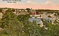
Bird's-eye view c. 1912
-
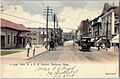
Main Street in 1906
-
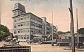
Shoe factory c. 1910
-
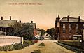
Lincoln Street c. 1908


Geography
Marlborough is located at 42°21′3″N 71°32′51″W / 42.35083°N 71.54750°W. The city covers about 22.2 square miles (57.24 km2). Most of this is land, with about 1.1 square miles (2.85 km2) of water. The Assabet River flows through the northwest part of the city. Marlborough has three large lakes: Lake Williams, Millham Reservoir, and Fort Meadow Reservoir. Part of Fort Meadow Reservoir is also in Hudson.
Major roads like Interstate 495, U.S. Route 20, and Massachusetts Route 85 cross through Marlborough. The eastern end of Interstate 290 is also in the city.
Neighboring Towns
Marlborough is in eastern Massachusetts. It shares borders with six other towns:
 |
Berlin | Hudson | Sudbury | |
| Northborough | ||||
| Southborough | Framingham |
Population and People
| Historical population | ||
|---|---|---|
| Year | Pop. | ±% |
| 1790 | 1,554 | — |
| 1800 | 1,735 | +11.6% |
| 1810 | 1,674 | −3.5% |
| 1820 | 1,952 | +16.6% |
| 1830 | 2,077 | +6.4% |
| 1840 | 2,101 | +1.2% |
| 1850 | 2,941 | +40.0% |
| 1860 | 5,911 | +101.0% |
| 1870 | 8,474 | +43.4% |
| 1880 | 10,127 | +19.5% |
| 1890 | 13,805 | +36.3% |
| 1900 | 13,609 | −1.4% |
| 1910 | 14,579 | +7.1% |
| 1920 | 15,028 | +3.1% |
| 1930 | 15,587 | +3.7% |
| 1940 | 15,154 | −2.8% |
| 1950 | 15,756 | +4.0% |
| 1960 | 18,819 | +19.4% |
| 1970 | 27,936 | +48.4% |
| 1980 | 30,617 | +9.6% |
| 1990 | 31,813 | +3.9% |
| 2000 | 36,255 | +14.0% |
| 2010 | 38,499 | +6.2% |
| 2020 | 41,793 | +8.6% |
| 2022* | 40,971 | −2.0% |
| * = population estimate. Source: United States Census records and Population Estimates Program data. Source: |
||
In 2000, there were 36,255 people living in Marlborough. There were 14,501 households and 9,280 families. The population density was about 1,719 people per square mile (663.8 per km2).
About 30.4% of households had children under 18. About 51.5% were married couples. The average household had 2.47 people. The average family had 3.07 people.
The median age in the city was 36 years old. About 23.3% of the population was under 18. About 11.6% were 65 or older.
Economy
Marlborough has many businesses, stores, and restaurants.
The southwest part of the city, called the "Southwest Quadrant," has many office parks. These corporate buildings are near Interstate 495. This area is a busy industrial center.
The Marlborough Center Historic District is in the downtown area on Main Street. It has restaurants, hair salons, and other businesses.
Marlborough Regional Chamber of Commerce
The Marlborough Regional Chamber of Commerce helps businesses in Marlborough and five nearby towns. It supports over 650 businesses and thousands of workers. The Chamber works to improve transportation and recognize Marlborough's downtown as a cultural area.
Education

Marlborough has several schools for students of all ages.
Public Schools
- High schools (grades 9–12):
- Marlborough High School
- Assabet Valley Regional Technical High School
- Middle school (grades 6–8):
- 1LT Charles W. Whitcomb School
- Elementary schools (grades K–5):
- Raymond C. Richer Elementary School
- Francis J. Kane Elementary School
- Sgt. Charles J. Jaworek Elementary School
- Goodnow Brothers Elementary School
- Preschool (up to Pre-K):
- Early Childhood Center
Charter Schools
- Advanced Math & Science Academy (grades 6–12)
Private Schools
- Hillside School (grades 5–9)
- Wayside Academy (grades 9–12)
- New England Innovation Academy (grades 6–12)
After School Programs
- Boys & Girls Clubs of Metrowest
Transportation
Marlborough is close to major highways like Routes 495, 290, 20, and the Massachusetts Turnpike. Buses connect it to nearby towns and cities.
Major Highways
Marlborough is served by two Interstates, one U.S. Highway, and one state route:
| Route number | Type | Local name | Direction |
|---|---|---|---|
| Interstate | Interstate 495 (Massachusetts) | north–south | |
| Interstate | Interstate 290 (Massachusetts) | east–west | |
| United States highway | Boston Post Rd., East/West Main St. Lakeside Ave and Granger Blvd. |
east–west | |
| State route | Washington St., Bolton St. and Maple St. |
north–south |
Bus Services
The MetroWest Regional Transit Authority (MWRTA) runs bus services in the area. Marlborough is one of 16 communities it serves.
- MWRTA Bus Route 7 connects Marlborough to Southborough. It also goes to the Framingham Commuter Rail Station. From there, you can take a train to Boston or Worcester.
- MWRTA Bus Route 7C (Inner City Marlborough) travels through Marlborough. It goes through downtown and connects to shopping centers and Marlborough Hospital.
- MWRTA Bus Route 15 connects Marlborough with Hudson to the north. It stops at Marlborough Hospital, Boston Scientific, and Walmart.
Media
Newspapers and Online News
- Community Advocate: A weekly newspaper for Marlborough and nearby towns.
- The MetroWest Daily News: A daily newspaper covering Marlborough and the surrounding MetroWest area.
- Marlborough Patch: An online daily news source.
Television
- Channel 8 (Comcast), Channel 34 (Verizon): WMCT-TV Your Community Station.
- Channel 96 (Comcast), Channel 33 (Verizon): Marlborough Access, Public Access Television.
- Channel 98: Marlborough Public Schools' student-run station.
Arts
Ghost Light Players of MetroWest
Ghost Light Players is a local theater group in Marlborough. They have been performing plays since 2012. Some of their past shows include Hamlet, Romeo and Juliet, and Macbeth.
Sports
Marlborough Country Club
The Marlborough Country Club hosted a professional golf tournament called The Marlborough Classic from 1981 to 1983. Famous golfers like Arnold Palmer won there. The tournament later moved and is now called Bank of America Championship.
Sports Teams
- Providence Bruins: An AHL hockey team. They played in Marlborough temporarily during the 2020–21 season.
- Boston Junior Bruins: A youth ice hockey team in the USPHL league.
- Marlboro Shamrocks: A semi-professional football team.
Points of Interest

- Assabet River Rail Trail
- Callahan State Park
- Capt. Peter Rice House
- John Brown Bell
- Marlborough Country Club
- Marlborough Memorial Beach
- Marlborough Center Historic District
- New England Sports Center
- Solomon Pond Mall
Notable People

Many interesting people have connections to Marlborough:
- Horatio Alger, Jr.: An author who graduated from high school in Marlborough in 1847.
- Walter Brennan: An American actor and singer who attended Marlborough High School.
- Mike Burns: An Olympian and World Cup soccer player.
- Marcia Cross: An actress known for Desperate Housewives; she graduated from Marlborough High School in 1980.
- Joey Graceffa: An actor, author, singer, and YouTube personality.
- Gregory Maguire: The author of Wicked: The Life and Times of the Wicked Witch of the West.
- Bill Simmons: A well-known sports personality.
Sister Cities and Towns
Marlborough has special connections with cities and towns in other countries:
 – Akiruno, Tokyo, Japan (since 1998)
 – Ipatinga, Minas Gerais, Brazil (since 2009)
 – Marlborough, Wiltshire, England, United Kingdom (since 1657)
See also
 In Spanish: Marlborough (Massachusetts) para niños
