North Hempstead, New York facts for kids
Quick facts for kids
North Hempstead, New York
|
|||
|---|---|---|---|
| Town of North Hempstead | |||
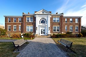
North Hempstead Town Hall, located in Manhasset, the town seat.
|
|||
|
|||
| Nickname(s):
TONH; TNH
|
|||
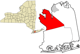
Location in Nassau County and the state of New York.
|
|||
| Country | |||
| State | |||
| County | Nassau | ||
| First settled | 1643 | ||
| Incorporated as a town | 1784 | ||
| Named for | Its location north of Hempstead | ||
| Town Seat | Manhasset | ||
| Government | |||
| • Type | Town Council | ||
| Area | |||
| • Total | 69.19 sq mi (179.21 km2) | ||
| • Land | 53.54 sq mi (138.68 km2) | ||
| • Water | 15.65 sq mi (40.54 km2) | ||
| Elevation | 102 ft (31 m) | ||
| Population
(2020)
|
|||
| • Total | 237,639 | ||
| • Rank | 3rd in Nassau County | ||
| • Density | 4,438.28/sq mi (1,713.63/km2) | ||
| Time zone | UTC-5 (Eastern (EST)) | ||
| • Summer (DST) | UTC-4 (EDT) | ||
| ZIP codes |
11001-11599
|
||
| Area codes | 516, 363 | ||
| FIPS code | 36-059-53000 | ||
| Website | |||
North Hempstead is a town in Nassau County, New York. It's located on Long Island, a large island near New York City. In 2020, about 237,639 people lived here, making it one of the biggest towns in New York State.
Contents
History of North Hempstead
The area that is now North Hempstead was first settled by Europeans around 1643. Back then, it was part of the larger town of Hempstead.
Forming a New Town
During the American Revolution, people in the southern part of Hempstead mostly supported the British. However, those in the northern part, who were often from New England, supported the American fight for independence. After the war ended, the Town of North Hempstead was officially created in 1784. It split off from the original Hempstead area.
Growth and Development
North Hempstead grew richer when the Long Island Rail Road reached Great Neck. Steamboat service from Manhattan also started in 1836. These new ways to travel made the town more connected and helped it grow.
Villages and Governance
The Town of North Hempstead includes 30 incorporated villages. These villages have the power to make their own rules about things like building and land use. This helps them protect their local areas. No new villages have been formed since 1932. Also, a rule change in 1936 made it harder for new villages to get zoning powers.
Some parts of North Hempstead are not part of any village. These are called unincorporated areas. The main Town of North Hempstead government manages these areas directly.
Geography of North Hempstead
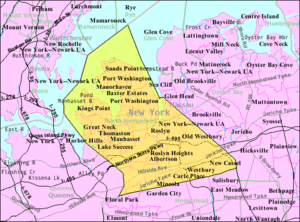
North Hempstead is located on Long Island. Its western border touches Queens County, which is part of New York City. To the north, the Long Island Sound forms the border with Bronx County and Westchester County.
To the east, North Hempstead shares borders with the Town of Oyster Bay and the City of Glen Cove. Its southern neighbor is the Town of Hempstead.
Land and Water Area
According to the U.S. Census Bureau, North Hempstead covers about 69.2 square miles (179.2 square kilometers). Most of this area, about 53.5 square miles (138.7 square kilometers), is land. The rest, about 15.7 square miles (40.5 square kilometers), is water.
Unique Naming
North Hempstead is the only town on Long Island that doesn't have a smaller community (like a hamlet or village) with the exact same name within its borders. Other towns on Long Island, like Hempstead and Oyster Bay, have smaller areas named after them.
Population and People
| Historical population | |||
|---|---|---|---|
| Census | Pop. | %± | |
| 1790 | 2,696 | — | |
| 1800 | 2,413 | −10.5% | |
| 1810 | 2,700 | 11.9% | |
| 1830 | 3,062 | — | |
| 1840 | 3,891 | 27.1% | |
| 1850 | 4,291 | 10.3% | |
| 1860 | 5,419 | 26.3% | |
| 1870 | 6,540 | 20.7% | |
| 1880 | 7,560 | 15.6% | |
| 1890 | 8,134 | 7.6% | |
| 1900 | 12,048 | 48.1% | |
| 1910 | 17,831 | 48.0% | |
| 1920 | 26,370 | 47.9% | |
| 1930 | 62,202 | 135.9% | |
| 1940 | 83,385 | 34.1% | |
| 1950 | 142,613 | 71.0% | |
| 1960 | 219,088 | 53.6% | |
| 1970 | 235,007 | 7.3% | |
| 1980 | 218,624 | −7.0% | |
| 1990 | 211,393 | −3.3% | |
| 2000 | 221,372 | 4.7% | |
| 2010 | 226,322 | 2.2% | |
| 2020 | 237,639 | 5.0% | |
| U.S. Decennial Census | |||
In 2000, about 222,611 people lived in North Hempstead. The population density was about 4,155 people per square mile. The town is home to many different groups of people.
Most residents were White, but there were also many African American and Asian residents. About 9.83% of the population identified as Hispanic or Latino.
The population includes people of all ages. In 2000, about 23.6% of residents were under 18 years old. About 16.6% were 65 years or older. The average age in the town was 40 years.
Communities in North Hempstead
North Hempstead is made up of many different neighborhoods. These can be either "incorporated villages" or "unincorporated hamlets."
Incorporated Villages
These villages have their own local governments and rules. North Hempstead has 31 incorporated villages:
- Baxter Estates
- East Hills (partly in the Town of Oyster Bay)
- East Williston
- Floral Park (mostly in the Town of Hempstead)
- Flower Hill
- Garden City (mostly in the Town of Hempstead)
- Great Neck
- Great Neck Estates
- Great Neck Plaza
- Kensington
- Kings Point
- Lake Success
- Manorhaven
- Mineola (partly in the Town of Hempstead)
- Munsey Park
- New Hyde Park (southern half in the Town of Hempstead)
- North Hills
- Old Westbury (partly in the Town of Oyster Bay)
- Plandome
- Plandome Heights
- Plandome Manor
- Port Washington North
- Roslyn
- Roslyn Estates
- Roslyn Harbor (partly in the Town of Oyster Bay)
- Russell Gardens
- Saddle Rock
- Sands Point
- Thomaston
- Westbury
- Williston Park
Unincorporated Hamlets
These areas do not have their own local governments. They are directly managed by the Town of North Hempstead.
- Albertson
- Carle Place
- Garden City Park
- Glenwood Landing (partly with Oyster Bay)
- Great Neck Gardens
- Greenvale (partly with Oyster Bay)
- Harbor Hills
- Herricks
- Hillside Manor
- Manhasset (This is where the town's main office is located.)
- Manhasset Hills
- New Cassel
- North New Hyde Park
- Port Washington
- Roslyn Heights
- Saddle Rock Estates
- Searingtown
- Strathmore
- University Gardens
Other Important Locations
- Cow Neck (also called Manhasset Neck) — A piece of land that sticks out into the Long Island Sound.
- Great Neck — Another peninsula reaching into the Long Island Sound.
- Hempstead Harbor — A bay that is part of the Long Island Sound.
- Lake Success — A lake near the western edge of the town.
- Little Neck Bay — A bay of the Long Island Sound.
- Manhasset Bay — A bay of the Long Island Sound.
- United States Merchant Marine Academy — A special school for training officers for the merchant marine, located in Kings Point.
Economy and Jobs
North Hempstead is home to many businesses and job opportunities.
Major Employers
- Northwell Health, a large healthcare provider, has its main office in Great Neck. It is the biggest employer on Long Island.
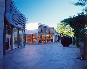
- The Americana Manhasset is a very famous shopping area in Manhasset. It's known for its many stores.
- Several companies have their headquarters or offices in North Hempstead. These include Sumitomo Corporation, Systemax, Pall, Publishers Clearing House, and NPD Group. Many of these are in Port Washington.
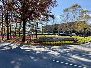
Here are some of the biggest employers in North Hempstead as of 2021:
| # | Employer | Number of Employees |
|---|---|---|
| 1 | North Shore University Hospital | 13,697 |
| 2 | NYU Langone Hospital – Long Island | 8,706 |
| 3 | St. Francis Hospital | 3,573 |
| 4 | Northwell Health Home Care | 1,001 |
| 5 | Daniel Gale Sotheby's International Realty | 950 |
| 6 | Northwell Health Stern Family Center | 576 |
| 7 | Laffey Real Estate | 560 |
| 8 | Coffee Distributing Corp | 390 |
| 9 | Sunharbor Manor | 220 |
| 10 | Sands Point Center for Health & Rehabilitation | 197 |
Transportation in North Hempstead
Getting around North Hempstead is possible by train, bus, and car.
Train Service
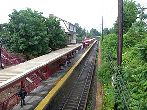
The Long Island Rail Road (LIRR) provides train service.
- The Oyster Bay Branch runs near the town from Mineola to Greenvale.
- The Main Line goes through the southern parts of the town. It has stations like Merillon Avenue and Westbury.
- The Port Washington Branch serves the northern part of the town. It includes stations from Great Neck to Port Washington.
Bus Service
Most bus routes in North Hempstead are run by Nassau Inter-County Express (NICE Bus). Some MTA Bus Routes also come into Nassau County from Queens.
Major Roads
Several important roads pass through North Hempstead, making it easy to travel by car.
 Interstate 495, known as the Long Island Expressway, is the main highway.
 Northern State Parkway is another major road. Trucks are not allowed on this parkway.
 Meadowbrook State Parkway and
  Wantagh State Parkway also have sections within the town.
 New York State Route 25A is a key east-west road in the northern part of the town.
 New York State Route 25B and
  New York State Route 25 are other state routes.
 New York State Route 101 runs north-south through areas like Flower Hill and Port Washington.
- Other important local roads include Beacon Hill Road, Bryant Avenue, East Broadway, Glen Cove Road, Herricks Road, Mineola Avenue, Old Country Road, Old Northern Boulevard, Shelter Rock Road, West Shore Road, and Willis Avenue.
Airports
- Sands Point Seaplane Base is a small airport for seaplanes.
See also
 In Spanish: North Hempstead (Nueva York) para niños
 | William M. Jackson |
 | Juan E. Gilbert |
 | Neil deGrasse Tyson |


