Geography of Tennessee facts for kids
The U.S. state of Tennessee is a really interesting place with many different types of land. Imagine going from tall mountains in the east to flat, rich farmlands near the Mississippi River in the west! Tennessee is divided into three main parts, called Grand Divisions: East Tennessee, Middle Tennessee, and West Tennessee. These divisions are different in their geography, culture, and even how they are organized legally.
Contents
About Tennessee's Land
Tennessee is located in the Southeastern United States. A big part of the state is known as the Upland South, and the eastern side is part of the Appalachian region. Tennessee covers about 42,143 square miles (109,140 km²), and a small part of that (about 2.2%) is water. It's the 16th smallest state in terms of land area.
The state stretches about 440 miles (710 km) from east to west and about 112 miles (180 km) from north to south. As we mentioned, Tennessee has three main parts: East, Middle, and West Tennessee. People sometimes call them "The Three Tennessees" because each has its own unique history and culture.
Tennessee shares borders with eight other states! To the north are Kentucky and Virginia. To the east is North Carolina. To the south are Georgia, Alabama, and Mississippi. And to the west are Arkansas and Missouri. This means Tennessee is tied with Missouri for bordering the most other states.
The Tennessee River flows through the state, dividing it into sections. The very center of Tennessee is near Murfreesboro, which is the state's sixth-largest city. You'll also notice that the time zone changes as you travel across the state, with parts in the Eastern and Central Time.
Tennessee's Edges
Tennessee's eastern border generally follows the highest peaks of the Blue Ridge Mountains. On the western side, the Mississippi River forms the border. However, because the Mississippi River can change its path due to floods, the border doesn't always perfectly follow the river in every spot.
The northern and southern borders of Tennessee don't follow natural features like rivers or mountains. The northern border was supposed to be a straight line, but old surveys made it a bit wiggly in places. The southern border was also placed about 1 mile (1.6 km) south of where it was originally planned. This has even caused some disagreements with Georgia because it affects their access to the Tennessee River.
Land Shapes and Features
Tennessee has many different landforms and types of terrain. It has six main geographic regions, moving from east to west. These are part of three bigger areas:
- The Blue Ridge Mountains, the Ridge-and-Valley Appalachians, and the Cumberland Plateau (all part of the Appalachian Mountains).
- The Highland Rim and Nashville Basin (part of the Interior Low Plateaus of the Interior Plains).
- The East Gulf Coastal Plain (part of the Atlantic Plains).
Smaller regions include the southern tip of the Cumberland Mountains, the Western Tennessee Valley, and the Mississippi Alluvial Plain.
The highest point in Tennessee is Clingmans Dome, which is 6,643 feet (2,025 meters) above sea level. Clingmans Dome is also the highest point on the famous Appalachian Trail and the third-highest peak in the United States east of the Mississippi River. The lowest point in the state is 178 feet (54 meters) above sea level, found on the Mississippi River near the Mississippi state line in Memphis.
Did you know Tennessee has the most caves in the United States? There are more than 10,000 documented caves here!
Blue Ridge Mountains
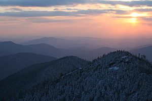
The Blue Ridge Mountains are found along Tennessee's eastern edge. This area is known for its tall mountains and rugged land. It includes famous ranges like the Great Smoky Mountains, the Bald Mountains, and the Unicoi Mountains. The mountains in Tennessee's Blue Ridge area are, on average, about 5,000 feet (1,500 meters) above sea level. The state's border with North Carolina generally follows the highest peaks in this range, including Clingmans Dome, which is the highest point in Tennessee.
Not many people live in the Blue Ridge area. Most of it is protected land, like the Cherokee National Forest, the Great Smoky Mountains National Park, and several state parks.
Ridge-and-Valley Appalachians
West of the Blue Ridge Mountains, you'll find the Ridge-and-Valley Appalachians, which stretch for about 55 miles (89 km). This area is also called the Tennessee Valley or Great Valley of East Tennessee. It has many long, parallel ridges and valleys that run from northeast to southwest, just like the rest of the Appalachian mountain range. Most of these ridges are not very high, but some taller ones are often called mountains.
This region is home to many towns and three of Tennessee's biggest cities: Knoxville and Chattanooga (the third and fourth-largest cities), and the Tri-Cities area, which includes Bristol, Johnson City, and Kingsport. Many smaller rivers come together in this region to form the Tennessee River.
Cumberland Plateau and Cumberland Mountains
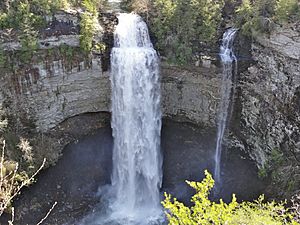
To the west of the Tennessee Valley, the land rises to form the Cumberland Plateau. This area is mostly flat on top, like a huge tableland. The elevation of the Cumberland Plateau ranges from about 1,500 to 2,500 feet (460 to 760 meters) above sea level, with an average of about 2,000 feet (610 meters). The eastern part of the plateau is generally higher than the western part. Most of the water on the plateau flows west into the Cumberland River.
The eastern edge of the plateau is quite clear, but the western side is more uneven. It has many long, winding stream valleys separated by rocky cliffs, and you can find lots of waterfalls here, like the famous Fall Creek Falls. The Cumberland Mountains, with peaks over 3,500 feet (1,100 meters), are in the northeastern part of the plateau in Tennessee. The boundary between East and Middle Tennessee runs along the top of the Cumberland Plateau, and so does the line between Eastern and Central Time.
Highland Rim and Nashville Basin
West of the Cumberland Plateau is the Highland Rim, which is a raised plain that surrounds the Nashville Basin. Both of these areas are part of the Interior Low Plateaus. The Highland Rim is Tennessee's largest geographic region and is often split into the Eastern and Western Highland Rim. The Eastern Highland Rim has fairly flat plains with rolling hills, averaging about 1,000 feet (300 meters) above sea level. The Western Highland Rim and western parts of the Nashville Basin have uneven, rounded hills with steep valleys and winding streams.
Much of the Nashville Basin is relatively flat and has rich, fertile farmland. It's also home to many different kinds of wildlife. The basin averages about 600 feet (180 meters) above sea level, but some hills can be much higher. Underneath the Nashville Basin and parts of the Eastern Highland Rim, there's a lot of porous limestone rock close to the surface. This creates a landscape called karst, which has many caves, sinkholes, and underground streams. Nashville, the state capital, is in the northwestern part of the Basin. Clarksville, the state's fifth-largest city, is in the northwestern Highland Rim.
To the west of the Highland Rim is a narrow area called the Western Tennessee Valley. This hilly strip, about 10 miles (16 km) wide, runs along the banks of the Tennessee River. The Tennessee River forms the border between Middle and West Tennessee here.
Gulf Coastal Plain and Mississippi Embayment
West of the Tennessee River is the Gulf Coastal Plain. This is a wide, flat area that starts at the Gulf of Mexico and stretches northward into southern Illinois. In Tennessee, this plain has two distinct parts. The eastern part has low, rolling hills and wide stream valleys, sometimes called the West Tennessee Highlands. As you move west, the land gradually becomes flatter.
The flat western part of the plain has incredibly fertile soils, making it one of the best areas in the country for growing cotton. This area also has thick, rich soil called loess. It ends at steep bluffs that overlook the Mississippi embayment. This is the westernmost part of Tennessee and is part of the larger Mississippi Alluvial Plain. This flat strip, often called the Mississippi Bottoms, is about 10 to 14 miles (16 to 23 km) wide and is less than 300 feet (91 meters) above sea level. It includes lowlands, floodplains, and swamps, and is sometimes considered part of the Mississippi Delta region. Memphis, the largest city in West Tennessee, is located in the southwestern corner of the Gulf Coastal Plain. All of West Tennessee is part of the Jackson Purchase historical region.
Tennessee's Rocks and Earth
The types of rocks and how they were formed in Tennessee generally match the state's land features. The rocks tend to get younger as you move from east to west. Most of the Blue Ridge Mountains in the east were formed during the Precambrian era, which means they have some of the oldest rocks in the state, over 1 billion years old! These rocks include granite and sedimentary rocks that have been changed by heat and pressure.
Most of the rock formations in East and Middle Tennessee were formed during the Paleozoic era. For example, shale and carbonate rocks from the Ordovician period are found in the Nashville Basin and Ridge-and-Valley region. The inner part of the Nashville Basin is like a giant geological dome that was pushed up by Earth's forces between 300 and 400 million years ago.
The Highland Rim was formed during the Mississippian era about 350 million years ago. It sits on top of soluble limestone bedrock, which has created the karst landscape with caves and sinkholes. The Cumberland Plateau was formed during the Pennsylvanian period about 300 million years ago. It's mostly made of sandstone, silt, and shale, and it has a lot of coal.
The eastern part of the Gulf Coastal Plain has rocks from the Mesozoic Cretaceous period (66 to 145 million years ago). Most of the plain to the west has younger deposits from the Cenozoic Tertiary era (2.6 to 66 million years ago). The very youngest rock formations in Tennessee are sands and silts deposited during the current Quaternary period (in the last 2.6 million years). These are found in the Mississippi Alluvial Plain and river valleys.
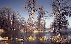
Tennessee experiences some earthquake activity, though strong earthquakes are rare. There are two main earthquake zones. The Eastern Tennessee Seismic Zone covers all of East Tennessee and often has small earthquakes. The New Madrid Seismic Zone is in the northwestern part of the state. This zone caused a series of very strong earthquakes between December 1811 and February 1812. These earthquakes were so powerful that they actually formed Reelfoot Lake near Tiptonville!
Tennessee's Waterways
Tennessee has three major rivers: the Tennessee, Cumberland, and Mississippi.
The Tennessee River starts in Knoxville where the Holston and French Broad rivers meet. It flows southwest to Chattanooga, then goes into Alabama, and later re-enters Tennessee in the western part of the state before flowing north into Kentucky. Important rivers that flow into the Tennessee River include the Clinch, Little Tennessee, and Duck rivers.
The Cumberland River flows through the north-central part of the state. It starts in the northeastern Highland Rim, goes through Nashville, and then turns northwest towards Clarksville before entering Kentucky. Its main branches in Tennessee are the Obey, Caney Fork, and Harpeth rivers.
The Mississippi River forms the state's western border, where Memphis is located. Rivers that flow into the Mississippi from Tennessee include the Obion, Forked Deer, and Wolf rivers.
Organizations like the Tennessee Valley Authority (TVA) and the U.S. Army Corps of Engineers operate many dams on the Tennessee and Cumberland rivers and their branches. These dams create many large lakes (reservoirs) across the state.
About half of Tennessee's land drains into the Tennessee River. The Cumberland River basin covers the northern half of Middle Tennessee. Most of West Tennessee drains into the Lower Mississippi River. Almost all of Tennessee's water eventually flows into the Mississippi River watershed, except for a small part in southeastern Tennessee where the Conasauga River flows into the Mobile Bay watershed.
Tennessee's Nature and Wildlife
Tennessee is part of a temperate deciduous forest biome, which means it has forests where trees lose their leaves in the fall. Because of its many different types of land and environments, Tennessee is the most biodiverse inland state. The Great Smoky Mountains National Park is known as the most biodiverse national park, and Tennessee's Duck River has the most different kinds of living things of any waterway in North America!
The state is home to 340 types of birds, 325 kinds of freshwater fish, 89 mammals, 77 amphibians, and 61 reptiles.
Forests cover about 52% of Tennessee's land. The most common type is oak–hickory forest. You can find Appalachian oak–pine and cove hardwood forests in the Blue Ridge Mountains and Cumberland Plateau. Bottomland hardwood forests are common in the Gulf Coastal Plain. Pine forests are also found throughout the state. Some of the last large American chestnut trees grow in the Nashville Basin, and they are being used to help grow new trees that are resistant to a disease called blight.
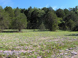
Middle Tennessee has many unusual and rare ecosystems called cedar glades. These areas have shallow limestone rock with very little soil, and they are home to many unique plant species that aren't found anywhere else.
Common mammals you might see in Tennessee include white-tailed deer, red and gray foxes, coyotes, raccoons, opossums, wild turkeys, rabbits, and squirrels. Black bears live in the Blue Ridge Mountains and on the Cumberland Plateau in Eastern Tennessee. Tennessee has the third-highest number of amphibian species, and it's especially famous for its salamanders. The Great Smoky Mountains National Park is even called the "Salamander Capital of the World"! The state also ranks second in the nation for the variety of its freshwater fish.
Tennessee's Weather
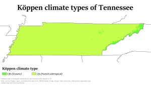
Most of Tennessee has a humid subtropical climate, which means it has hot, humid summers and mild to cool winters. However, some higher areas in the Appalachians have a mountain temperate or humid continental climate because they are cooler. The Gulf of Mexico greatly influences Tennessee's weather, bringing most of the state's rain with winds from the south.
Generally, Tennessee has hot summers and mild to cool winters, with plenty of rain throughout the year. The most rain usually falls in winter and spring (December to April). The driest months are usually August to October. On average, the state gets about 50 inches (130 cm) of rain each year. Snowfall varies, from about 5 inches (13 cm) in West Tennessee to over 80 inches (200 cm) in the highest mountains in East Tennessee.
Summers are typically hot and humid, with most of the state seeing average high temperatures around 90°F (32°C). Winters are usually mild to cool, getting colder at higher elevations. For most areas outside the highest mountains, the average overnight lows are near freezing. The hottest temperature ever recorded in Tennessee was 113°F (45°C) in Perryville on August 9, 1930. The coldest was -32°F (-36°C) in Mountain City on December 30, 1917.
Even though Tennessee is far from the coast, it can still be affected by the leftover parts of tropical storms (hurricanes) that weaken over land. These can bring a lot of rain. The state averages about fifty days of thunderstorms each year, and some of these can be strong, with large hail and damaging winds. Tornadoes are possible throughout the state, with West and Middle Tennessee being the most likely areas to see them. Sometimes, very strong tornadoes occur, like those in April 2011. On average, Tennessee has about 15 tornadoes per year.
Winter storms can sometimes cause problems, and ice storms are more common than heavy snowstorms. Fog can also be a frequent issue in some parts of the state, especially in East Tennessee.
Climate data
| Monthly Normal High and Low Temperatures For Various Tennessee Cities (F) | ||||||||||||
| City | Jan | Feb | Mar | Apr | May | Jun | Jul | Aug | Sep | Oct | Nov | Dec |
|---|---|---|---|---|---|---|---|---|---|---|---|---|
| Bristol | 44/25 | 49/27 | 57/34 | 66/41 | 74/51 | 81/60 | 85/64 | 84/62 | 79/56 | 68/43 | 58/35 | 48/27 |
| Chattanooga | 50/31 | 54/33 | 63/40 | 72/47 | 79/56 | 86/65 | 90/69 | 89/68 | 82/62 | 72/48 | 61/40 | 52/33 |
| Knoxville | 47/30 | 52/33 | 61/40 | 71/48 | 78/57 | 85/65 | 88/69 | 87/68 | 81/62 | 71/50 | 60/41 | 50/34 |
| Memphis | 50/31 | 55/36 | 63/44 | 72/52 | 80/61 | 89/69 | 92/73 | 92/72 | 86/65 | 75/52 | 62/43 | 52/34 |
| Nashville | 47/28 | 52/31 | 61/39 | 70/47 | 78/57 | 85/65 | 89/70 | 89/69 | 82/61 | 71/49 | 59/40 | 49/32 |
| Climate data for Memphis (Memphis Int'l), 1981−2010 normals, extremes 1872−present | |||||||||||||
|---|---|---|---|---|---|---|---|---|---|---|---|---|---|
| Month | Jan | Feb | Mar | Apr | May | Jun | Jul | Aug | Sep | Oct | Nov | Dec | Year |
| Record high °F (°C) | 79 (26) |
81 (27) |
87 (31) |
94 (34) |
99 (37) |
104 (40) |
108 (42) |
107 (42) |
103 (39) |
95 (35) |
86 (30) |
81 (27) |
108 (42) |
| Mean daily maximum °F (°C) | 49.8 (9.9) |
54.7 (12.6) |
63.9 (17.7) |
73.0 (22.8) |
81.2 (27.3) |
88.9 (31.6) |
91.6 (33.1) |
91.3 (32.9) |
85.1 (29.5) |
74.4 (23.6) |
62.6 (17.0) |
52.1 (11.2) |
72.4 (22.4) |
| Daily mean °F (°C) | 41.2 (5.1) |
45.5 (7.5) |
54.0 (12.2) |
62.9 (17.2) |
71.7 (22.1) |
79.6 (26.4) |
82.7 (28.2) |
82.0 (27.8) |
75.2 (24.0) |
64.1 (17.8) |
53.2 (11.8) |
43.6 (6.4) |
63.0 (17.2) |
| Mean daily minimum °F (°C) | 32.6 (0.3) |
36.3 (2.4) |
44.1 (6.7) |
52.9 (11.6) |
62.2 (16.8) |
70.3 (21.3) |
73.8 (23.2) |
72.7 (22.6) |
65.2 (18.4) |
53.8 (12.1) |
43.7 (6.5) |
35.1 (1.7) |
53.6 (12.0) |
| Record low °F (°C) | −8 (−22) |
−11 (−24) |
12 (−11) |
27 (−3) |
36 (2) |
48 (9) |
52 (11) |
48 (9) |
36 (2) |
25 (−4) |
9 (−13) |
−13 (−25) |
−13 (−25) |
| Average precipitation inches (mm) | 3.98 (101) |
4.39 (112) |
5.16 (131) |
5.50 (140) |
5.25 (133) |
3.63 (92) |
4.59 (117) |
2.88 (73) |
3.09 (78) |
3.98 (101) |
5.49 (139) |
5.74 (146) |
53.68 (1,363) |
| Average snowfall inches (cm) | 1.9 (4.8) |
1.3 (3.3) |
0.4 (1.0) |
0 (0) |
0 (0) |
0 (0) |
0 (0) |
0 (0) |
0 (0) |
0 (0) |
trace | 0.2 (0.51) |
3.8 (9.7) |
| Average precipitation days (≥ 0.01 in) | 9.5 | 9.2 | 10.5 | 9.6 | 10.3 | 9.0 | 8.8 | 6.8 | 7.3 | 7.5 | 9.5 | 9.7 | 107.7 |
| Average snowy days (≥ 0.1 in) | 1.2 | 0.8 | 0.4 | 0 | 0 | 0 | 0 | 0 | 0 | 0 | 0 | 0.4 | 2.8 |
| Average relative humidity (%) | 68.2 | 66.4 | 63.2 | 62.5 | 66.4 | 66.8 | 69.1 | 69.6 | 71.3 | 66.2 | 67.7 | 68.8 | 67.2 |
| Mean monthly sunshine hours | 166.6 | 173.8 | 215.3 | 254.6 | 301.5 | 320.6 | 326.9 | 307.0 | 251.2 | 245.9 | 173.0 | 151.9 | 2,888.3 |
| Percent possible sunshine | 53 | 57 | 58 | 65 | 69 | 74 | 74 | 74 | 68 | 70 | 56 | 50 | 65 |
| Source: NOAA (relative humidity 1961−1990, sun 1961−1987) | |||||||||||||
| Climate data for Nashville (Nashville Int'l), 1981–2010 normals, extremes 1871−present | |||||||||||||
|---|---|---|---|---|---|---|---|---|---|---|---|---|---|
| Month | Jan | Feb | Mar | Apr | May | Jun | Jul | Aug | Sep | Oct | Nov | Dec | Year |
| Record high °F (°C) | 78 (26) |
84 (29) |
89 (32) |
91 (33) |
96 (36) |
109 (43) |
107 (42) |
106 (41) |
105 (41) |
94 (34) |
88 (31) |
79 (26) |
109 (43) |
| Mean maximum °F (°C) | 68.0 (20.0) |
73.0 (22.8) |
80.2 (26.8) |
85.1 (29.5) |
88.7 (31.5) |
94.2 (34.6) |
97.1 (36.2) |
96.5 (35.8) |
93.0 (33.9) |
85.5 (29.7) |
77.7 (25.4) |
68.5 (20.3) |
98.3 (36.8) |
| Mean daily maximum °F (°C) | 46.9 (8.3) |
51.8 (11.0) |
61.0 (16.1) |
70.5 (21.4) |
78.2 (25.7) |
86.0 (30.0) |
89.3 (31.8) |
89.0 (31.7) |
82.4 (28.0) |
71.7 (22.1) |
60.3 (15.7) |
49.5 (9.7) |
69.7 (20.9) |
| Mean daily minimum °F (°C) | 28.4 (−2.0) |
31.6 (−0.2) |
39.0 (3.9) |
47.5 (8.6) |
56.8 (13.8) |
65.4 (18.6) |
69.5 (20.8) |
68.4 (20.2) |
60.7 (15.9) |
48.9 (9.4) |
39.4 (4.1) |
31.3 (−0.4) |
48.9 (9.4) |
| Mean minimum °F (°C) | 8.8 (−12.9) |
13.5 (−10.3) |
22.5 (−5.3) |
31.2 (−0.4) |
42.7 (5.9) |
54.3 (12.4) |
61.6 (16.4) |
59.4 (15.2) |
45.4 (7.4) |
32.7 (0.4) |
23.8 (−4.6) |
13.8 (−10.1) |
4.7 (−15.2) |
| Record low °F (°C) | −17 (−27) |
−13 (−25) |
2 (−17) |
23 (−5) |
34 (1) |
42 (6) |
51 (11) |
47 (8) |
36 (2) |
26 (−3) |
−1 (−18) |
−10 (−23) |
−17 (−27) |
| Average precipitation inches (mm) | 3.75 (95) |
3.94 (100) |
4.11 (104) |
4.00 (102) |
5.50 (140) |
4.14 (105) |
3.64 (92) |
3.17 (81) |
3.41 (87) |
3.04 (77) |
4.31 (109) |
4.24 (108) |
47.25 (1,200) |
| Average snowfall inches (cm) | 2.6 (6.6) |
2.3 (5.8) |
0.9 (2.3) |
0 (0) |
0 (0) |
0 (0) |
0 (0) |
0 (0) |
0 (0) |
trace | 0 (0) |
0.5 (1.3) |
6.3 (16) |
| Average precipitation days (≥ 0.01 in) | 10.3 | 10.3 | 10.7 | 10.8 | 11.7 | 10.0 | 10.2 | 8.4 | 7.5 | 8.0 | 9.8 | 11.2 | 118.9 |
| Average snowy days (≥ 0.1 in) | 2.1 | 2.3 | 0.7 | 0 | 0 | 0 | 0 | 0 | 0 | 0.1 | 0 | 1.0 | 6.2 |
| Average relative humidity (%) | 70.4 | 68.5 | 64.6 | 63.2 | 69.5 | 70.4 | 72.8 | 73.1 | 73.7 | 69.4 | 70.2 | 71.4 | 69.8 |
| Mean monthly sunshine hours | 139.6 | 145.2 | 191.3 | 231.5 | 261.8 | 277.7 | 279.0 | 262.1 | 226.4 | 216.8 | 148.1 | 130.6 | 2,510.1 |
| Percent possible sunshine | 45 | 48 | 52 | 59 | 60 | 64 | 63 | 63 | 61 | 62 | 48 | 43 | 56 |
| Source: NOAA (relative humidity and sun 1961−1990), Weather.com | |||||||||||||


