
Image: Greater Manchester UK location map 2

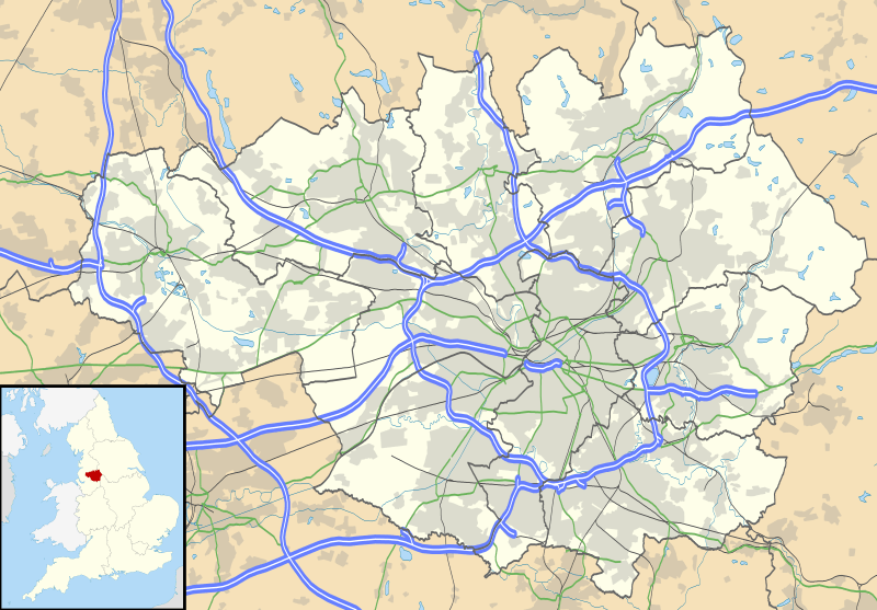
Description: Map of Greater Manchester, UK with the following information shown: Administrative borders Coastline, lakes and rivers Roads and railways Urban areas The data includes both primary routes and railway lines. Equirectangular map projection on WGS 84 datum, with N/S stretched 165% Geographic limits: West: 2.80W East: 1.90W North: 53.70N South: 53.32N
Title: Greater Manchester UK location map 2
Credit: Ordnance Survey OpenData. Administrative borders and coastline data from Boundary-Line product. All other geographic data from Meridian 2 product. Inset derived from England location map.svg by Spischot.
Author: Nilfanion, created using Ordnance Survey data
Permission: This file is licensed under the Creative Commons Attribution-Share Alike 3.0 Unported license. Attribution: Contains Ordnance Survey data © Crown copyright and database right You are free: to share – to copy, distribute and transmit the work to remix – to adapt the work Under the following conditions: attribution – You must give appropriate credit, provide a link to the license, and indicate if changes were made. You may do so in any reasonable manner, but not in any way that suggests the licensor endorses you or your use. share alike – If you remix, transform, or build upon the material, you must distribute your contributions under the same or compatible license as the original. https://creativecommons.org/licenses/by-sa/3.0 CC BY-SA 3.0 Creative Commons Attribution-Share Alike 3.0 truetrue
Usage Terms: Creative Commons Attribution-Share Alike 3.0
License: CC BY-SA 3.0
License Link: https://creativecommons.org/licenses/by-sa/3.0
Attribution Required?: Yes
Image usage
More than 100 pages link to this image. The following list shows the first 100 page links to this image only. A full list is available.
- Abram, Greater Manchester
- Adswood
- Ainsworth, Greater Manchester
- Alt, Greater Manchester
- Altrincham
- Ancoats
- Ashton-under-Lyne
- Aspull
- Astley, Greater Manchester
- Atherton, Greater Manchester
- Baguley
- Balderstone, Greater Manchester
- Bamford, Greater Manchester
- Bamfurlong, Greater Manchester
- Bardsley, Greater Manchester
- Baretrees, Greater Manchester
- Belfield, Greater Manchester
- Belle Vue, Manchester
- Beswick, Manchester
- Birtle, Greater Manchester
- Blackfriars, Greater Manchester
- Blackrod
- Bolton
- Bowdon, Greater Manchester
- Bradford, Manchester
- Bradshaw, Greater Manchester
- Bredbury
- Brooklands, Greater Manchester
- Broughton, Salford
- Buckley, Greater Manchester
- Bury
- Bury, Greater Manchester
- Busk, Greater Manchester
- Carrington, Greater Manchester
- Castlesteads, Greater Manchester
- Castleton, Greater Manchester
- Cheadle, Greater Manchester
- Cheetham, Manchester
- Chorlton-cum-Hardy
- Chorlton-on-Medlock
- Clayton, Manchester
- Clifton, Greater Manchester
- Coalshaw Green
- Coppice, Greater Manchester
- Cowhill, Greater Manchester
- Cox Green, Greater Manchester
- Davenport, Greater Manchester
- Deane, Greater Manchester
- Denshaw
- Denton, Greater Manchester
- Diggle, Greater Manchester
- Dukinfield
- Eagley
- Eccles, Greater Manchester
- Egerton, Greater Manchester
- Ellenbrook, Greater Manchester
- Elton, Greater Manchester
- Fairfield, Tameside
- Flixton, Greater Manchester
- Freehold, Greater Manchester
- Gigg, Greater Manchester
- Godley, Greater Manchester
- Golborne
- Gorton
- Greenacres, Greater Manchester
- Greenfield, Greater Manchester
- Greengate, Greater Manchester
- Greengate, Salford
- Greenmount, Greater Manchester
- Haigh, Greater Manchester
- Hale, Greater Manchester
- Halliwell, Greater Manchester
- Harwood, Greater Manchester
- Haughton, Greater Manchester
- Hawkshaw, Greater Manchester
- Hazel Grove
- Heaton, Greater Manchester
- Heights, Greater Manchester
- Heywood, Greater Manchester
- Hindley, Greater Manchester
- Holcombe, Greater Manchester
- Hollinwood, Greater Manchester
- Hopwood, Greater Manchester
- Horwich
- Hulme
- Hyde, Greater Manchester
- Ince-in-Makerfield
- Langley, Greater Manchester
- Langworthy, Salford
- Lees, Greater Manchester
- Leigh, Greater Manchester
- Littleborough, Greater Manchester
- Longsight
- Oldham
- Ringway, Greater Manchester
- Rochdale
- Salford
- Shaw and Crompton
- Stockport
- Tyldesley
