The Maritimes facts for kids
Quick facts for kids
The Maritimes
Les Maritimes (French)
|
|
|---|---|
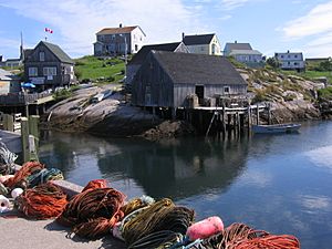
Peggy's Cove, Nova Scotia, a classic Maritime view
|
|
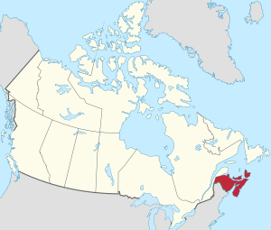
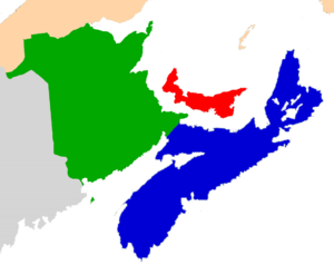
The Maritime provinces (red) in Canada
|
|
| Provinces | |
| Largest city | Halifax |
| Area | |
| • Total | 130,017.11 km2 (50,199.89 sq mi) |
| Population
(2021)
|
|
| • Total | 1,899,324 |
| • Density | 14.608262/km2 (37.835225/sq mi) |
| Demonym(s) | Maritimer |
| Time zone | UTC−4:00 (AST) |
| • Summer (DST) | UTC−3:00 (ADT) |
The Maritimes is a special region in Eastern Canada. It includes three provinces: New Brunswick, Nova Scotia, and Prince Edward Island. In 2021, about 1.9 million people lived here, which is about 5% of Canada's total population. When you add Newfoundland and Labrador, these provinces together form Atlantic Canada.
The Maritimes are located right on the Atlantic Ocean. They have many bays and gulfs, like the Gulf of Maine and Gulf of St. Lawrence. To the southwest, you'll find New England in the United States. To the north, there's Quebec's Gaspé Peninsula, and to the northeast is the island of Newfoundland. People have thought about uniting these provinces into a "Maritime Union" many times. The first talks in 1864 helped lead to Canadian Confederation, which formed the larger country of Canada. The Mi'kmaq, Maliseet, and Passamaquoddy people are the original inhabitants of the Maritimes. Later, Acadian and British settlers arrived in the 1600s.
Contents
What Does "Maritime" Mean?
The word "maritime" means "of the sea" or "near the sea." It comes from the Latin word maritimus. So, any land next to the ocean can be called maritime. However, the term Maritimes has been used for a long time to specifically mean New Brunswick, Nova Scotia, and Prince Edward Island. All three of these provinces are located along the Atlantic Ocean.
History of the Maritimes
The history of the Maritimes began over 10,000 years ago, after the ice from the last ice age melted. The first people, called First Nations, started living here during the "Early Period," which ended around 6,000 years ago.
The "Middle Period" began 6,000 years ago. During this time, sea levels rose as more glaciers melted. This period saw the start of the "Laurentian tradition" among the Archaic Indians. We know they lived here because of burial mounds found in the Saint John River valley.
The "Late Period" lasted from 3,000 years ago until Europeans arrived. During this time, First Nations people organized into groups like the Algonquian-speaking Abenaki Nation. The Mi'kmaq Nation lived across Nova Scotia, Prince Edward Island, eastern New Brunswick, and the southern Gaspé Peninsula. The Maliseet Nation, who were mostly farmers, settled along the Saint John River. The Passamaquoddy Nation lived along the coast of the Bay of Fundy. The Mi'kmaq also settled on the south coast of Newfoundland, but they were fewer in number than the Beothuk Nation there.
First European Visitors
After Newfoundland, the Maritimes were the second part of Canada where Europeans settled. Some evidence suggests that Viking explorers might have visited the Vinland region around 1000 AD. Their settlement at L'Anse aux Meadows in Newfoundland and Labrador has been dated to this time. They might have explored further into the Maritimes.
Later, explorers like Giovanni Caboto (for England) and Giovanni da Verrazzano (for France) sailed near Maritime waters. Portuguese explorers also mapped parts of the region. However, it was French explorer Jacques Cartier who first explored the area in detail and claimed it for France.
In 1604, Pierre Dugua, Sieur de Mons and Samuel de Champlain led an expedition. They set up the second permanent European settlement in what is now Canada and the United States, after St. Augustine in Florida. Champlain's settlement at Saint Croix Island later moved to Port Royal (now Annapolis Royal). This French settlement was even older than the English settlement at Jamestown. Champlain is known as the founder of New France's province of Canada.
Acadia: Early French Settlements
Champlain's success in this region, which was named Acadie, led to French immigrants settling around the Bay of Fundy. These settlers called themselves Acadien. They built small farming villages across what is now mainland Nova Scotia and New Brunswick, as well as Île-Saint-Jean (Prince Edward Island) and Île-Royale (Cape Breton Island).
As English colonies grew to the south, and wars broke out between England and France, Acadia became very important. In 1613, raiders from Virginia captured Port-Royal. In 1621, France gave Acadia to Scotland, and it was renamed Nova Scotia.
By 1632, Acadia was returned to France. More French settlers arrived, mostly from regions like Brittany and Normandy. Important settlements grew in the Beaubassin area and along the Saint John River. France, however, focused more on its larger colony of New France in the St. Lawrence River valley.
Colonial Wars and Conflicts
For over 70 years (1689–1763), there were many wars between New England and Acadia. These were part of bigger wars between England and France in Europe. New England was allied with the Iroquois, while Acadian settlers were allied with the Wabanaki Confederacy.
To protect its interests, France began building a huge fortress at Louisbourg on Île-Royale in 1719. In 1745, the British captured Louisbourg. But three years later, it was given back to France.
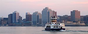
In 1749, to balance the power of Louisbourg, the British founded Halifax. They built a major naval base and citadel there.
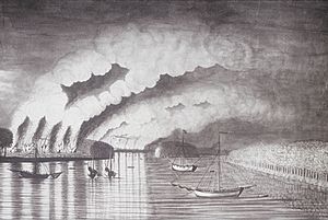
During the last colonial war, the French and Indian War (part of the Seven Years' War), fighting continued in Nova Scotia. The British had captured Acadia in 1710. For 45 years, the Acadians refused to promise full loyalty to Britain. They also helped supply the French fortresses. Because of this, the British decided to remove the Acadians from their lands.
The British began the Expulsion of the Acadians in 1755. Over the next nine years, more than 12,000 Acadians were forced to leave Nova Scotia.
In 1758, Louisbourg was attacked again by over 27,000 British soldiers and sailors. After the French surrendered, Louisbourg was completely destroyed. With Louisbourg gone, French and Mi'kmaw resistance in the region ended. Britain gained control over the entire Maritime region. The Indigenous people then signed the Halifax Treaties.
American Revolution and New Colonies
After the Seven Years' War, empty Acadian lands were settled by people from New England and Yorkshire. Île-Royale was renamed Cape Breton Island and became part of Nova Scotia. Some Acadians who had been deported returned, settling on the eastern coasts of New Brunswick.
The American Revolutionary War affected Nova Scotia and St. John's Island (Prince Edward Island). American ships were attacked by privateers (private ships allowed to attack enemy ships). Some coastal towns were also raided. Charlottetown, the capital of St. John's Island, was attacked in 1775.
The biggest impact of this war was the arrival of many Loyalist refugees. These were people who supported Britain during the American Revolution. About 34,000 Loyalists settled in the region, especially in Shelburne and Parrtown (now Saint John).
After the war ended in 1783, the Loyalists in New Brunswick convinced Britain to create a new colony called New Brunswick in 1784. At the same time, Cape Breton Island also became a separate colony. St. John's Island was renamed Prince Edward Island in 1798.
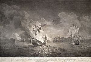
The War of 1812 also affected shipping in the Maritime colonies. However, the strong British Royal Navy presence in Halifax prevented major American attacks. The most notable event was the British capture of the American ship USS Chesapeake in Halifax.
The 1800s and Confederation
In 1820, Cape Breton Island was merged back into Nova Scotia.
More British settlers came to the Maritimes in the late 1700s and 1800s. Many were Scottish people displaced by the Highland Clearances or Irish people escaping the Great Irish Famine. This is why much of the region has strong Celtic roots. Scottish Gaelic was once widely spoken, especially in Cape Breton.
During the American Civil War, many Maritimers joined the Union Army, though some joined the Confederate Army. The war mostly affected shipping. Maritime ships did well carrying goods for the North, as Union ships were at risk from Confederate raiders.
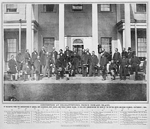
By the 1860s, Maritimers worried about the large American army and threats from the Fenian Brotherhood, who wanted to end British rule in Ireland. Britain was also reducing its support to the region. These concerns led Maritime politicians to plan a meeting about a Maritime Union in September 1864 in Charlottetown.
Delegates from the Province of Canada (now Ontario and Quebec) also came to this Charlottetown Conference. They suggested a larger union of all British North America. This led to more meetings in Quebec City and London, resulting in the British North America Act, 1867. Only Nova Scotia and New Brunswick joined Canada at first. Prince Edward Island joined six years later in 1873.
Major Cities and Towns
The main communities in the Maritimes include:
- Halifax and Cape Breton in Nova Scotia.
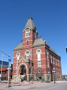
- Moncton, Saint John, and Fredericton in New Brunswick.
- Charlottetown in Prince Edward Island.
Climate and Weather
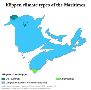
Even though it's called the Maritimes, the region has a humid continental climate. This means it has warm summers. In coastal Nova Scotia, the difference between summer and winter temperatures is not as big as in other parts of Canada. However, inland New Brunswick has much colder winters, more like other continental areas.
Summers are a bit cooler near the ocean, but they are still warm. Yarmouth in Nova Scotia has a very strong ocean influence, almost like an oceanic climate. But even there, winter nights are cold. The northern parts of New Brunswick have very cold, continental winters.
| Location | Province | July (°C) | July (°F) | January (°C) | January (°F) |
|---|---|---|---|---|---|
| Halifax | Nova Scotia | 23 / 14 °C | 73 / 57 °F | 0 / −8 °C | 32 / 18 °F |
| Sydney | Nova Scotia | 23 / 12 °C | 73 / 54 °F | −1 / −9 °C | 30 / 16 °F |
| Fredericton | New Brunswick | 25 / 13 °C | 77 / 55 °F | −4 / −15 °C | 25 / 5 °F |
| Saint John | New Brunswick | 22 / 11 °C | 72 / 52 °F | −2 / −13 °C | 28 / 9 °F |
| Moncton | New Brunswick | 24 / 13 °C | 75 / 55 °F | −3 / −14 °C | 27 / 7 °F |
| Charlottetown | Prince Edward Island | 23 / 14 °C | 73 / 57 °F | −3 / −12 °C | 27 / 10 °F |
| Yarmouth | Nova Scotia | 21 / 12 °C | 70 / 54 °F | 1 / −7 °C | 34 / 19 °F |
| Campbellton | New Brunswick | 23 / 10 °C | 73 / 50 °F | −9 / −20 °C | 16 / −4 °F |
| Greenwood | Nova Scotia | 26 / 14 °C | 79 / 57 °F | −1 / −10 °C | 30 / 14 °F |
People of the Maritimes
For a long time, the Maritimes were mostly rural. People worked in fishing, farming, forestry, and coal mining.
Most Maritimers have roots from Western Europe, especially Scottish Canadians, Irish Canadians, English Canadians, and Acadians. New Brunswick has a much larger French-speaking population than the other two provinces. In the past, many people also spoke Canadian Gaelic.
There are also Black Canadians in the Maritimes, many of whom are descendants of Black Loyalists or black refugees from the War of 1812. Most of these live in Nova Scotia.
Mi'kmaq reserves are found in all three provinces. There is also a smaller population of Maliseet people in western New Brunswick.
Economy of the Maritimes
Current Economy
The Maritimes have a smaller population compared to other parts of Canada. The region mostly exports natural resources, manufactured goods, and services. The economy has always relied on fishing, logging, farming, and mining. In the late 1800s, industries like steel production and coal mining grew. However, after Canada was formed, these industries faced challenges.
Today, the Maritime economy is growing in manufacturing and is shifting towards a service economy. Important manufacturing areas include Pictou County, Truro, the Annapolis Valley, and the Strait of Canso area in Nova Scotia. Also, Summerside in Prince Edward Island, and the Miramichi area in New Brunswick are important.
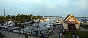
Many coastal areas have become popular tourist spots. These include parts of Prince Edward Island, Cape Breton Island, and the South Shore of Nova Scotia. Other growing industries include information technology, medicine, insurance, and finance. Research from the region's many universities also helps the economy.
Nova Scotia's economy also benefits from offshore petroleum (oil and gas) exploration near Sable Island. This started in the 1960s, with oil production in the 1980s and natural gas in the late 1990s.
Transportation has also improved with modern ports, new highways, and better airports. The Canso Causeway and the Confederation Bridge have made travel easier.
Despite these improvements, the three Maritime provinces are still among the poorer regions in Canada. While cities are growing, rural areas that depend on resources have struggled. Many people have moved away for better opportunities. Wages and family incomes are lower here, and property values are less. This means less tax money for the provinces.
Since the 1990s, the region has faced tough times. The fishing industry declined, coal mines and a steel mill on Cape Breton Island closed, and military bases in all three provinces shut down. However, New Brunswick is home to one of the largest military bases in the Commonwealth of Nations (CFB Gagetown), which is very important to Fredericton's economy and culture.
Historical Economy: The "Golden Age"

The Maritimes were not always less wealthy than other parts of Canada. The mid-1800s, especially the 1850s and 1860s, is sometimes called a "Golden Age." During this time, the region had strong growth, many factories, and a large international shipping industry.
However, recent studies show that this "Golden Age" was mostly for a small group of wealthy people in cities like Halifax. Most farmers, fishermen, and labourers in rural areas still lived in poverty. Many people had to move away to find work.
Why the Decline?
Historians and economists debate why the Maritimes' economy fell behind. Some say it was due to bad policy decisions. Others argue it was due to unavoidable changes in technology and geography.
One big change was in transportation. The Intercolonial Railway connected the Maritimes to central Canada in the 1870s. This meant Maritime factories now competed directly with those in central Canada. Trade also shifted from Europe and the U.S. to other parts of Canada.
At the same time, wooden sailing ships were replaced by larger, faster steel steamships. The Maritimes had been a major shipbuilding area, so this change hurt the industry. Larger ships also preferred bigger ports like New York and Montreal over smaller Maritime cities. Even the Cunard Line, started by Maritime-born Samuel Cunard, stopped visiting Halifax often.
Some argue that policies after Confederation, like tariffs (taxes on imported goods) and railway freight rates, hurt the Maritime economy. They say these policies were designed by central Canada to benefit itself. For example, some believe that central Canadian companies bought Maritime factories and then closed them to move production to central Canada.
The Maritimes also lacked very large cities like Montreal and Toronto, which benefited greatly from new industries and railways. While New Brunswick has mid-sized cities like Saint John, Moncton, and Fredericton, and Nova Scotia has a growing Halifax, the region remained mostly rural and resource-dependent for a long time.
Another idea is the "staples thesis." This suggests that the decline was due to the natural resources available. The Maritimes lacked the large rivers needed for cheap hydro-electric power, which was key to growth in Quebec and Ontario. Also, the costs of getting resources like coal were higher, and the soil for farming was poorer.
The Maritimes are the only Canadian provinces that joined Confederation in the 1800s and kept their original small colonial borders. Other provinces grew much larger by adding new territories. The wealth from energy and natural resources in these larger territories only became clear to other provinces in the 1900s.
Despite these challenges, the Maritimes have changed a lot. Each area has developed its own strengths. Saint John became a center for timber and shipbuilding, and now for oil refining. Northern New Brunswick focuses on pulp and paper. Moncton became a transportation hub. Halifax is a major retail and service center. Prince Edward Island relies on farming, fishing, and tourism.
Main Industries
The main industry in the Maritime provinces is fishing. This includes catching lobster, mackerel, tuna, and salmon. Growing oysters and salmon in farms is also becoming more important.
Nova Scotia's Economy
Nova Scotia has strong industries in agriculture, forestry, and fishing.
Prince Edward Island's Economy
Tourism is very important to PEI's economy. The famous book Anne of Green Gables was written in PEI, which brings many tourists to the island. PEI is also known for its agriculture, especially potatoes, and its fishing industries.
New Brunswick's Economy
Agriculture and forestry are two major industries in New Brunswick. Even though it has a long coastline, New Brunswick's industries have not always relied only on fishing. The province's history of shipbuilding is directly linked to its forest resources. Because of this, people in New Brunswick often feel more connected to their forests and rivers than to the sea.
See also
 In Spanish: Provincias marítimas de Canadá para niños
 | Claudette Colvin |
 | Myrlie Evers-Williams |
 | Alberta Odell Jones |


