
Ring of Fire facts for kids


The Ring of Fire (also called the Pacific Ring of Fire or the Circum-Pacific belt) is a giant, horseshoe-shaped area around the edges of the Pacific Ocean. It is famous for having huge numbers of active volcanoes and frequent earthquakes.
This energetic belt stretches for about 40,000 km (25,000 mi) (around 25,000 miles) and is up to 500 km (310 mi) wide. It touches the coasts of North America, South America, Asia, and several island nations across Oceania.
Inside the Ring of Fire, you will find between 750 and 915 active or dormant volcanoes. That equals about two-thirds of all the volcanoes in the world! It is also home to roughly 90% of the world's earthquakes. Many of the most powerful tremors in human history happened along this path.
The Ring of Fire was created by the constant movement of giant pieces of the Earth's crust called tectonic plates. When these plates crash into each other, one plate often slides underneath another in a process called subduction. This movement forms deep oceanic trenches, triggers massive quakes, and melts rock into liquid magma that rises up to fuel explosive volcanoes.
Contents
- What Is the History and Science Behind the Name?
- Understanding Earth's Moving Tectonic Plates
- Deep Ocean Trenches and Gaps in the Ring
- Ring of Fire Geographic Distribution
- Major Natural Events Along the Ring
- Exploring Volcanoes in South America
- Volcanoes and Hazards in North America
- Dangerous Volcanoes and Islands in Asia
- Island Arcs in the Southwest Pacific
- How Volcanic Soils Help the Environment
- How Do Scientists Monitor the Ring of Fire?
- See Also
- Images for kids
What Is the History and Science Behind the Name?
How Did People Name the Ring of Fire?
For thousands of years, ancient civilizations linked volcanoes with fire. Ancient Greek and Roman scholars believed that deep underground fires burned inside the Earth. Even though scientists now know that magma is molten rock rather than real fire, the historic name "Ring of Fire" remained popular.
In 1825, an early scientist named George Julius Poulett Scrope wrote about the vast chains of volcanoes circling the Pacific Ocean. Later, in the 1850s, sailors on naval expeditions noticed that islands from South America to Asia lined up in an immense volcanic circle. By the early 1900s, writers and geologists regularly referred to this region as a great volcanic ring.
In 1912, geologist Patrick Marshall created the term "Andesite Line" to show the boundary where different types of volcanic rocks form around the Pacific basin. This line closely matches the modern path of the Ring of Fire.
How Does Plate Tectonics Explain It?

During the 1960s, scientists developed the theory of plate tectonics. This theory explains that Earth's outer crust is broken into giant moving slabs.
These plates glide slowly over the hotter layer beneath them called the mantle. The Ring of Fire exists because the huge Pacific plate is colliding with many surrounding plates.
Where plates push together at convergent boundaries, one heavy oceanic plate is pushed down into the hot mantle. This process is called subduction. As the sinking plate goes deeper, water trapped inside lowers the melting point of the rock above it. This creates sticky, gas-rich magma that rises toward the surface, building powerful cone-shaped stratovolcanoes.
Understanding Earth's Moving Tectonic Plates

How Did the Ring of Fire Change Over Time?
The Ring of Fire has been active for more than 35 million years. However, subduction around the Pacific edges began much earlier, more than 145 million years ago during the age of the dinosaurs.
Over millions of years, older plates like the Izanagi, Farallon, and Kula plates were slowly pushed down into Earth's mantle and disappeared. As the continents drifted to their current positions, the modern Pacific plate grew and took over the ocean basin.
Around 35 million years ago, the present arrangement of subduction zones locked into place. This created the volcanic arcs we see today in places like Japan, the Americas, and New Zealand.
Which Tectonic Plates Meet Here Today?
The eastern boundary of the Ring of Fire involves collisions between large, broad plates:
- The Nazca plate and Antarctic plate dive under the South American plate, forming the tall Andes mountains.
- The Cocos plate slides under Central America and Mexico.
- The small Juan de Fuca plate dives under the North American plate in the Pacific Northwest.
- The Pacific plate dives under Alaska and the Aleutian Islands.
The western side of the Ring of Fire is much more complex:
- The Pacific plate dives under the Kamchatka Peninsula and Japan.
- The Philippine Sea plate collides with the Eurasian plate near the Philippines and Taiwan.
- A patchwork of smaller plates crunches together near Indonesia, Papua New Guinea, Fiji, and New Zealand.
Deep Ocean Trenches and Gaps in the Ring


What Are Ocean Trenches?
When an oceanic plate bends and plunges into the Earth, it creates a steep, V-shaped canyon on the ocean floor called an oceanic trench. These trenches are the deepest parts of our oceans.
Major trenches found along the Ring of Fire include:
- Mariana Trench: The deepest trench on Earth, plunging nearly 11,000 m (36,000 ft) down.
- Peru–Chile Trench: Running along the western coast of South America for thousands of kilometers.
- Aleutian Trench: Stretching along the southern coast of Alaska and its island chain.
- Japan Trench and Kuril–Kamchatka Trench: Lining the volcanic island arcs of East Asia.
- Philippine Trench, Tonga Trench, and Kermadec Trench: Carving deep valleys in the southwestern Pacific.
Why Are There Gaps in the Ring?
The Ring of Fire is not a solid, unbroken loop. It has several major gaps where subduction is not happening:
- In California, the Pacific plate slides sideways past the North American plate along the San Andreas Fault. Because this is a transform boundary, there are no subduction volcanoes there.
- In some parts of South America, the diving plate moves horizontally underneath the continent instead of plunging steeply down. This process, called flat-slab subduction, prevents magma from forming and leaves gaps with no active volcanoes.
- In western Canada and southeast Alaska, some volcanic areas are caused by the stretching and tearing of continental crust rather than subduction.
Ring of Fire Geographic Distribution
| Region / Country | Subduction Volcanoes | Other Volcanoes | Key Features |
|---|---|---|---|
| Antarctic Islands | 0 | 7 | Deception Island rift systems |
| Chile & Argentina | 104 | 4 | Home to giant Andean stratovolcanoes |
| Peru, Ecuador, Colombia | 51 | 0 | High altitude volcanic peaks |
| Central America | 72 | 0 | Active volcanic arc across six countries |
| Mexico | 26 | 8 | Trans-Mexican Volcanic Belt |
| United States (West Coast) | 22 | 9 | Cascade Volcanic Arc |
| United States (Alaska) | 80 | 4 | Aleutian Island Arc |
| Canada | 6 | 16 | Garibaldi Volcanic Belt |
| Russia (Kamchatka & Kurils) | 111 | 0 | Extremely active northern arcs |
| Japan | 81 | 26 | High density of active cones |
| Philippines | 41 | 0 | Explosive island volcanoes |
| Indonesia (Eastern islands) | 54 | 0 | Complex plate collision zone |
| Papua New Guinea & Solomons | 55 | 1 | Tropical volcanic islands |
| Vanuatu, Fiji, Tonga | 34 | 4 | Submarine volcanoes and islands |
| New Zealand | 26 | 0 | Taupo Volcanic Zone |
| Total | 913 | 79 | Largest concentration on Earth |
Major Natural Events Along the Ring
Massive Volcanic Eruptions
The Ring of Fire has produced the largest volcanic explosions in recent geological history. Scientists measure the power of eruptions using the Volcanic Explosivity Index (VEI), which ranks eruptions from 0 to 8 based on how much material they blast out.
The four largest eruptions of the last 11,700 years (the Holocene Epoch) all occurred along the Ring of Fire:
- Fisher Caldera in Alaska (around 8700 BC)
- Kurile Lake in Kamchatka, Russia (around 6450 BC)
- Mount Mazama in Oregon, USA (around 5677 BC), which collapsed to form famous Crater Lake
- Kikai Caldera in Japan (around 5480 BC)
Powerful Megathrust Earthquakes
When subducting plates get stuck, immense tension builds up over decades or centuries. When the fault suddenly slips, it releases massive amounts of energy as a megathrust earthquake.
These giant tremors often push the seafloor upward, creating enormous ocean waves called tsunamis that travel across entire oceans.
Four of the strongest earthquakes ever recorded happened in the Ring of Fire:
- 1960 Valdivia earthquake in Chile: The largest quake ever measured at magnitude 9.4–9.6.
- 1964 Alaska earthquake in the United States: Measured at magnitude 9.2, shaking the land for over four minutes.
- 2011 Tōhoku earthquake and tsunami in Japan: A magnitude 9.0–9.1 earthquake that caused massive ocean waves.
- 1952 Severo-Kurilsk earthquake in Russia: A magnitude 9.0 quake off the Kamchatka coast.
Exploring Volcanoes in South America


What Makes the Chilean Andes Unique?
Chile has one of the longest chains of active volcanoes on Earth, created by the Nazca plate sinking beneath South America.
- Ojos del Salado: Rising to 6,893 m (22,615 ft), this is the highest active volcano in the entire world, sitting on the border between Chile and Argentina.
- Villarrica: One of Chile's most active peaks. It is one of the rare volcanoes in the world that holds an open, bubbling lava lake inside its summit crater.
- Llaima: A huge, snow-covered stratovolcano that has erupted frequently since the 1600s, creating fiery lava fountains and fast-moving mudflows called lahars.
- Lascar: The most active volcano in the northern Chilean desert. In 1993, it produced a massive ash explosion that sent ash clouds flying over 1,600 km (990 mi) across South America.
- Calbuco: An explosive volcano in southern Chile known for violent blasts that throw volcanic bombs miles into the air.
What Are the Active Volcanoes of Peru and Ecuador?
Further north along the Andes, the subduction zone creates towering volcanic peaks across Peru, Ecuador, and Colombia.
- Sabancaya and Ubinas: Two of Peru's most active volcanoes. Sabancaya regularly sends ash plumes thousands of feet into the sky.
- Cotopaxi: Located near Quito, Ecuador, this peak reaches 5,897 m (19,347 ft). It is famous for its nearly symmetrical, glacier-covered cone and has erupted dozens of times over the past 300 years.
- Sangay: One of the world's most continuously active volcanoes, erupting almost constantly with explosive bursts of ash and glowing rock.
- Reventador: A very active volcano in the rainforest region of Ecuador that blasted an ash column 17 km (11 mi) high during a massive eruption in 2002.
Volcanoes and Hazards in North America


How Active Is Central America and Mexico?
The Central America Volcanic Arc runs parallel to the Pacific coastline through Guatemala, El Salvador, Honduras, Nicaragua, and Costa Rica.
- Santa Maria Volcano and Santiaguito in Guatemala: Santa Maria suffered a massive blast in 1902. Since then, a new lava dome called Santiaguito has been slowly growing and erupting at its base.
- Poás Volcano in Costa Rica: Known for its vibrant, steaming crater lake filled with hot, acidic water and bubbling mineral geysers.
- Popocatépetl in Mexico: Located near Mexico City, this giant stratovolcano is the second-highest mountain in Mexico and regularly puffs steam, gas, and ash into the air.
- El Chichón: A volcano in southern Mexico that erupted violently in 1982, forming a new lake-filled caldera.
What Are the Cascade Volcanoes in the United States?


In the Pacific Northwest of the United States, the subduction of the Juan de Fuca plate fuels the Cascade Volcanic Arc.
The most famous modern eruption in the United States happened on May 18, 1980, at Mount St. Helens in Washington State:
- Magma pushed up under the mountain, creating a giant bulge on the north face.
- A magnitude 5.1 earthquake shook the mountain, causing the entire north side to collapse in the largest landslide in recorded history.
- The sudden release of pressure caused the volcano to explode sideways in a massive lateral blast.
- A towering column of ash shot 19 km (12 mi) into the air, while hot pyroclastic flows swept across the landscape, flattening forests for miles around.
Other major peaks in the Cascades include Mount Rainier, Mount Shasta, Mount Adams, and Mount Hood. Geologists closely monitor these volcanoes because their thick glaciers could melt during an eruption, creating massive lahars (volcanic mudflows).
Offshore, the Cascadia subduction zone can generate enormous earthquakes. Scientists have discovered that massive magnitude 9.0 earthquakes strike the region every 400 to 600 years, with the last great quake occurring in the year 1700.
What Happens in Alaska and Canada?


- Alaska: Alaska has more than 50 active volcanoes along the Aleutian Arc, making it one of the most active volcanic zones in North America. These island volcanoes erupt frequently, sending ash into high-altitude flight routes used by commercial airplanes.
- Canada: Southwestern British Columbia contains the Garibaldi Volcanic Belt, which is the northern continuation of the Cascade Arc. Volcanoes like Mount Garibaldi, Mount Cayley, and the Mount Meager massif formed here. Mount Meager had a violent explosive eruption about 2,350 years ago, blasting ash high into the atmosphere.
Dangerous Volcanoes and Islands in Asia
.jpeg)


What Are the Volcanoes of Kamchatka?
The Kamchatka Peninsula in eastern Russia is a dramatic volcanic wilderness. It sits right above the deep Kuril-Kamchatka Trench.
- Kamchatka has around 160 volcanoes, and about 30 of them are currently active.
- Kliuchevskoi is the tallest active volcano in Eurasia, reaching an elevation of 4,750 m (15,580 ft). It regularly shoots fiery lava fountains high above its snowy cone.
- Shiveluch is one of Kamchatka's largest and most explosive volcanoes, known for producing massive ash plumes and growing steep lava domes.
How Does Japan Live with Volcanoes and Earthquakes?
Japan is an island nation created entirely by volcanic activity and plate collisions. About 10% of all active volcanoes in the world are located across the Japanese islands.
- Minor earthquakes happen daily in Japan, and students regularly practice safety drills to prepare for larger quakes.
- Mount Fuji: Standing at 3,776 m (12,388 ft), this is Japan's tallest mountain and a sacred cultural symbol. It is a stratovolcano that last erupted in 1707, dusting nearby Tokyo in volcanic ash.
- Mount Bandai: A volcano that experienced a massive blast and side-collapse in 1888, completely changing the surrounding landscape and creating several new lakes.
What Are the Active Volcanoes of the Philippines?
The Philippine archipelago is packed with active volcanoes caused by the subduction of the Philippine Sea plate.
- Mount Pinatubo: In June 1991, Pinatubo produced the second-largest volcanic eruption of the 20th century. It blasted millions of tons of sulfur dioxide gas and ash into the upper atmosphere, causing global temperatures to temporarily drop by about 0.5 °C (32.9 °F)* over the next two years.
- Mayon Volcano: Famous for its almost perfectly symmetrical cone shape. Mayon is the most active volcano in the Philippines, having erupted more than 50 times in recorded history.
- Taal Volcano: A complex volcano located inside a large caldera lake. Taal has erupted violently dozens of times, most recently producing major ash explosions in 2020.
- Kanlaon Volcano: An active stratovolcano on Negros Island that frequently produces explosive steam and ash blasts.
Island Arcs in the Southwest Pacific


How Does the Ring Connect in Indonesia and the Pacific Islands?
The southwest Pacific features a complicated maze of island arcs, deep trenches, and underwater volcanoes:
- Indonesia: Eastern Indonesian islands (such as Sulawesi, Halmahera, and the Banda Islands) sit on the edge of the Pacific plate system, featuring dozens of explosive volcanic peaks.
- Melanesian Islands: Chains of islands across Papua New Guinea, the Solomon Islands, and Vanuatu feature extremely active volcanoes that produce glowing lava lakes and undersea eruptions.
- Tonga and Samoa: The Tonga Trench hosts many underwater volcanoes called seamounts. The West Mata volcano was observed erupting bright orange lava on the seafloor over 1,200 m (3,900 ft) beneath the ocean surface.
What Is the Taupō Volcanic Zone in New Zealand?
New Zealand sits directly on the boundary between the Pacific plate and the Australian plate. The North Island contains the highly active Taupō Volcanic Zone:
- Whakaari/White Island: An active volcanic island in the Bay of Plenty that regularly releases steam, volcanic gases, and mud bursts.
- Mount Ruapehu: A large, active stratovolcano that features a warm, acidic crater lake at its summit. When Ruapehu erupts, melting snow and lake water can create fast-moving mudflows (lahars).
- Auckland volcanic field: A dormant volcanic area underneath New Zealand's largest city, containing over 50 volcanic hills, craters, and lava fields like Rangitoto Island.
How Volcanic Soils Help the Environment

Even though volcanoes can be dangerous, they also bring great benefits to our planet.
When volcanoes erupt, they spread mineral-rich ash across the surrounding land. Over thousands of years, this ash breaks down into a special type of dark, nutrient-rich soil called andosol (or andisol).
These soils are rich in natural volcanic glass, iron, magnesium, and phosphorus. Because these soils retain water well and supply essential minerals to plants, farmland near the Ring of Fire is among the most fertile agricultural ground on Earth. Countries like Indonesia, Japan, and Ecuador grow abundant crops of rice, coffee, and fruits along the slopes of their volcanic mountains.
How Do Scientists Monitor the Ring of Fire?
To protect communities living near the Ring of Fire, geologists and seismologists use advanced scientific instruments to track underground activity:
- Seismometers: Sensitive tools that detect tiny vibrations and earthquakes inside the crust, helping scientists know when magma is moving beneath a volcano.
- GPS and Satellite Radar: Instruments that measure tiny bulges or ground swelling on the flanks of volcanoes before an eruption.
- Gas Analyzers: Devices that measure the types of gases (such as sulfur dioxide and carbon dioxide) escaping from volcanic vents. Rising gas levels often signal that fresh magma is rising.
- Ocean Buoy Warning Systems: Deep-ocean sensors (like the DART system) that measure pressure changes in seawater to detect tsunamis within seconds and send early warnings to coastal cities.
See Also
 In Spanish: Cinturón de fuego del Pacífico para niños
- Decade Volcanoes
- Plate tectonics
- Subduction
- Tsunami
- Volcano
Images for kids
-
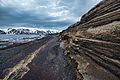
Layers of volcanic ash and rock on Deception Island in Antarctica
.jpg)
