Atlantic County, New Jersey facts for kids
Quick facts for kids
Atlantic County
|
|||
|---|---|---|---|
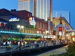
Atlantic City's boardwalk, the nation's first boardwalk, at night
|
|||
|
|||
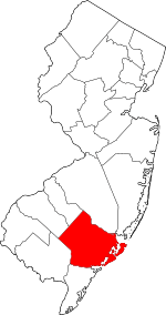
Location within the U.S. state of New Jersey
|
|||
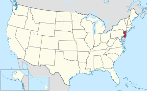 New Jersey's location within the U.S. |
|||
| Country | |||
| State | |||
| Founded | 1837 | ||
| Named for | Atlantic Ocean | ||
| Seat | Mays Landing | ||
| Largest municipality | Egg Harbor Township (population) Galloway Township (total area) Hamilton Township (land area) |
||
| Area | |||
| • Total | 671.84 sq mi (1,740.1 km2) | ||
| • Land | 555.51 sq mi (1,438.8 km2) | ||
| • Water | 116.32 sq mi (301.3 km2) 17.3% | ||
| Population
(2020)
|
|||
| • Total | 274,534 | ||
| • Estimate
(2023)
|
275,213 |
||
| • Density | 408.630/sq mi (157.7729/km2) | ||
| Time zone | UTC−5 (Eastern) | ||
| • Summer (DST) | UTC−4 (EDT) | ||
| Congressional district | 2nd | ||
Atlantic County is a county in New Jersey, a state in the United States. In 2020, it was the 15th most populated county in New Jersey. About 274,534 people lived there.
The county seat, which is the center of county government, is Mays Landing. Atlantic County is part of the famous Jersey Shore area. It is also part of the South Jersey region.
Egg Harbor Township is the most populated place in the county. It had 47,842 residents in 2020. Galloway Township covers the largest total area. Hamilton Township has the largest land area.
Atlantic County is part of the Atlantic City–Hammonton metropolitan area. This area is also part of the larger Philadelphia metro area.
Contents
History
Why it's called Atlantic County
The county got its name from the Atlantic Ocean. The ocean forms the county's eastern border.
How Atlantic County was formed
Native American people lived in New Jersey for thousands of years. By the 1600s, the Absegami tribe lived along the coast. They were part of the Unalachtigo Lenape tribe. They called the area Scheyichbi, meaning "land bordering the ocean."
European settlers from the Netherlands, Sweden, and England later arrived. In 1674, West Jersey was set up. In 1681, the government created Burlington County. Five years later, Gloucester County was formed from its southern part.
The area that is now Atlantic County was part of Gloucester County. In 1693, Great Egg Harbour Township was created. Early European settlers, many of them Quakers, lived near the waterways.
In 1695, John Somers bought land and started a ferry service. His son, Richard, built Somers Mansion between 1720 and 1726. This is the oldest home in the county. In 1698, Daniel Leeds explored the coast and found Leeds Point.
Folklore says that in 1735, Mother Leeds gave birth to her 13th child there. This child supposedly became the Jersey Devil. In the early 1700s, George May founded Mays Landing.
In 1774, Galloway Township was formed from Egg Harbor Township. By 1785, people in this area wanted their own local court. It was a long, four-day wagon ride to the court in Gloucester City.
In 1798, Weymouth Township was created. In 1813, Hamilton Township was formed. On February 7, 1837, New Jersey officially created Atlantic County. It included Galloway, Hamilton, Weymouth, and Egg Harbor townships. Mays Landing became the county seat. In 1830, Atlantic County was the least populated county in New Jersey.
Growth and changes
In 1837, Mullica Township was created. In 1852, Dr. Jonathan Pitney suggested Absecon Island as a health resort. He helped create the Camden and Atlantic Railroad Company. This company built a train line from Camden to the coast.
Atlantic City was founded on May 1, 1854. The train line opened on July 4, 1854. This made Atlantic City a popular place. In 1858, Egg Harbor City was formed. Hammonton was founded in 1866.
Many other towns were created as more people moved to the area. These included Margate City (1885), Somers Point (1886), Pleasantville (1889), and Linwood (1889). By 1885, more than half of the county's population lived in Atlantic City.
After the 1920s, Atlantic City's population started to decline. More people began moving to the mainland parts of the county.
In 1976, New Jersey voters approved allowing casinos in Atlantic City. Two years later, Resorts Atlantic City opened as the first casino. By 1990, there were 15 casinos. Some have closed since then, but new ones like the Borgata and Ocean Resort Casino have opened. The Hard Rock Hotel & Casino Atlantic City opened in 2018.
In 1978, the Pinelands National Reserve was created. This helps protect the Pine Barrens area, which includes parts of Atlantic County.
Geography
Atlantic County is about 100 miles south of New York City. It is about 60 miles southeast of Philadelphia. The county is roughly 30 miles wide and 20 miles tall.
According to the U.S. Census Bureau, the county has a total area of 671.84 square miles. About 555.51 square miles is land, and 116.32 square miles is water.
The county is on the Atlantic Coastal Plain. The Atlantic Ocean is to the east. There are three barrier islands along the coast: Absecon Island (where Atlantic City is), Brigantine Island, and Little Beach. West of these islands are marshlands and waterways. These form the Intracoastal Waterway.
Underneath the county is a large underground water source called the Kirkwood–Cohansey aquifer. This provides fresh water for local streams and rivers. The western part of the county is part of the Pine Barrens. This area has many pine and cedar trees and can have forest fires. The highest point in the county is about 150 feet above sea level. It is near the border with Camden County, close to Hammonton.
Climate
| Weather chart for Mays Landing, New Jersey | |||||||||||||||||||||||||||||||||||||||||||||||
|---|---|---|---|---|---|---|---|---|---|---|---|---|---|---|---|---|---|---|---|---|---|---|---|---|---|---|---|---|---|---|---|---|---|---|---|---|---|---|---|---|---|---|---|---|---|---|---|
| J | F | M | A | M | J | J | A | S | O | N | D | ||||||||||||||||||||||||||||||||||||
|
3.2
41
24
|
3
44
27
|
4.2
52
33
|
3.6
62
42
|
3.4
71
51
|
3.1
81
61
|
3.7
86
67
|
4.1
84
65
|
3.2
77
57
|
3.4
67
46
|
3.3
56
37
|
3.7
46
28
|
||||||||||||||||||||||||||||||||||||
| temperatures in °F precipitation totals in inches source: The Weather Channel |
|||||||||||||||||||||||||||||||||||||||||||||||
|
Metric conversion
|
|||||||||||||||||||||||||||||||||||||||||||||||
Atlantic County has a humid subtropical climate. This means it has hot, humid summers and mild winters.
In Mays Landing, the average temperature in January is 24°F. In July, it is 86°F. The lowest temperature ever recorded was -11°F in February 1979. The highest was 106°F in June 1969.
Average monthly rainfall is usually between 2.99 inches in February and 4.21 inches in March.
In December 1992, a strong storm called a nor'easter caused the highest tide ever in Atlantic City. It was 9.0 feet above the normal water level. In 2012, Hurricane Sandy hit near Brigantine. It brought very strong winds and a large storm surge. This caused flooding in low-lying areas.
Demographics
| Historical population | |||
|---|---|---|---|
| Census | Pop. | %± | |
| 1840 | 8,726 | — | |
| 1850 | 8,961 | 2.7% | |
| 1860 | 11,786 | 31.5% | |
| 1870 | 14,093 | 19.6% | |
| 1880 | 18,704 | 32.7% | |
| 1890 | 28,836 | 54.2% | |
| 1900 | 46,402 | 60.9% | |
| 1910 | 71,894 | 54.9% | |
| 1920 | 83,914 | 16.7% | |
| 1930 | 124,823 | 48.8% | |
| 1940 | 124,066 | −0.6% | |
| 1950 | 132,399 | 6.7% | |
| 1960 | 160,880 | 21.5% | |
| 1970 | 175,043 | 8.8% | |
| 1980 | 194,119 | 10.9% | |
| 1990 | 224,327 | 15.6% | |
| 2000 | 252,552 | 12.6% | |
| 2010 | 274,549 | 8.7% | |
| 2020 | 274,534 | 0.0% | |
| 2023 (est.) | 275,213 | 0.2% | |
| Historical sources: 1790-1990 1970-2010 2010 2020 |
|||
2010 census
In 2010, there were 274,549 people living in Atlantic County. There were 102,847 households and 68,702 families. The population density was about 494 people per square mile.
Most residents (65.40%) were White. About 16.08% were Black or African American. About 7.50% were Asian. People of Hispanic or Latino background made up 16.84% of the population.
About 29.8% of households had children under 18. About 45.6% were married couples. The average household had 2.61 people. The average family had 3.17 people.
About 23.3% of the population was under 18 years old. About 14.2% were 65 years or older. The average age was 39.9 years.
Economy
In 2021, Atlantic County's economy produced about $12.4 billion in goods and services. This was a good increase from the year before.
When Atlantic County was first created in 1837, people mostly fished and gathered clams and oysters. Shipbuilding was also an early industry. They used strong oak trees from the Pine Barrens.
Iron furnaces operated in the early 1800s. But they closed by the 1850s because of iron production in Philadelphia. Around this time, some cotton mills opened.
The first railroad opened in 1854. It helped Atlantic City grow and also boosted farming towns. Farmers started growing grapes, cranberries, and blueberries. The train made travel cheap, costing only 50¢. Many working-class people from Philadelphia visited. They were called "shoobies" because they often brought their lunch in shoe boxes.
The casino industry is a big part of the economy today. In 2012, it employed over 34,145 people.
Breweries, distilleries, and wineries
In 1864, Louis Nicholas Renault opened Renault Winery in Egg Harbor City. It is the oldest active winery in New Jersey. During the time when alcohol was banned, the winery could still sell wine for medicine.
Tomasello Winery started growing grapes in 1888. It opened to the public in 1933. Balic Winery opened in 1966 in Mays Landing. Sylvin Farms Winery opened in 1985. More recently, Bellview Winery (2001), DiMatteo Vineyards (2002), and Plagido's Winery (2007) have opened.
For beer, Tun Tavern Brewery opened in Atlantic City in 1998. It was named after a very old brew house in Philadelphia. Tuckahoe Brewing moved to Egg Harbor Township in 2015. Garden State Beer Company opened in 2016. Hidden Sands Brewery opened in 2018.
For spirits, Lazy Eye Distillery opened in 2014 in Buena Vista Township. Little Water Distillery opened in Atlantic City in 2016.
Municipalities
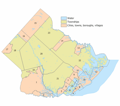
Atlantic County has 23 municipalities. Here is a list with their population and area from the 2010 Census:
| Municipality (with map key) |
Map key | Mun. type |
Pop. | Housing units |
Total area |
Water area |
Land area |
Pop. density |
Housing density |
School district | Communities |
|---|---|---|---|---|---|---|---|---|---|---|---|
| Absecon | 11 | City | 9,137 | 3,365 | 7.29 | 1.90 | 5.40 | 1558.8 | 623.6 | Pleasantville (9–12) (S/R) Absecon (PK-8) |
|
| Atlantic City | 10 | City | 38,497 | 20,013 | 17.04 | 6.29 | 10.75 | 3680.8 | 1862.2 | Atlantic City | |
| Brigantine | 12 | City | 7,716 | 9,222 | 10.36 | 3.98 | 6.39 | 1479.5 | 1443.8 | Atlantic City (9–12) (S/R) Brigantine (PK-8) |
|
| Buena | 17 | Borough | 4,501 | 1,855 | 7.58 | 0.00 | 7.58 | 607.4 | 244.8 | Buena | Landisville Minotola |
| Buena Vista Township |
18 | Township | 7,033 | 3,008 | 41.53 | 0.47 | 41.05 | 184.4 | 73.3 | Buena | Collings Lakes CDP (1,501) East Vineland CDP (925) Milmay CDP (part) (919( Newtonville CDP (742) Richland CDP (623) |
| Corbin City | 2 | City | 471 | 212 | 8.94 | 1.28 | 7.67 | 64.2 | 27.7 | Ocean City (9–12) (S/R) Upper Township (K-8) (S/R) |
|
| Egg Harbor City | 14 | City | 4,396 | 1,736 | 11.44 | 0.51 | 10.93 | 388.1 | 158.8 | Greater Egg Harbor (9–12) Egg Harbor City (PK-8) |
|
| Egg Harbor Township |
21 | Township | 47,842 | 16,347 | 74.93 | 8.34 | 66.6 | 650.5 | 245.5 | Egg Harbor Township | Bargaintown CDP (5,360) English Creek CDP (3,364) |
| Estell Manor | 1 | City | 1,668 | 673 | 55.10 | 1.78 | 53.32 | 32.5 | 12.6 | Buena (9–12) (S/R) Estell Manor (K-8) |
|
| Folsom | 16 | Borough | 1,811 | 717 | 8.44 | 0.24 | 8.2 | 229.8 | 87.4 | Hammonton (9–12) (S/R) Folsom (PK-8) |
Penny Pot |
| Galloway | 22 | Township | 37,813 | 14,132 | 115.21 | 26.14 | 89.07 | 419.3 | 158.7 | Greater Egg Harbor (9–12) Galloway Township (PK-8) |
Absecon Highlands CDP (1,414) Cologne CDP (1,461) Germania CDP (297) Leeds Point CDP (205) Oceanville CDP (793) Pomona CDP (7,416) Smithville CDP (7,242) Stockon University CDP (2,428) |
| Hamilton Township |
20 | Township | 27,484 | 10,196 | 113.07 | 1.94 | 111.13 | 238.5 | 91.8 | Greater Egg Harbor (9–12) Hamilton Township (PK-8) |
Mays Landing CDP (5,603) McKee City CDP (9,758) Mizpah CDP (479) |
| Hammonton | 15 | Town | 14,711 | 5,715 | 41.42 | 0.53 | 40.89 | 361.8 | 139.8 | Hammonton | |
| Linwood | 5 | City | 6,971 | 2,798 | 4.24 | 0.38 | 3.87 | 1834.9 | 723.9 | Mainland Regional (9–12) Linwood (PK-8) |
|
| Longport | 4 | Borough | 893 | 1,656 | 1.56 | 1.17 | 0.39 | 2323.7 | 4299.4 | Ocean City (9–12) (S/R) Margate (K-8) (S/R) |
|
| Margate City | 6 | City | 5,317 | 7,114 | 1.63 | 0.22 | 1.42 | 4490.3 | 5027.4 | Atlantic City (9–12) (S/R) Margate (K-8) |
|
| Mullica Township |
23 | Township | 5,816 | 2,360 | 56.9 | 0.48 | 56.42 | 108.9 | 41.8 | Greater Egg Harbor (9–12) Mullica Township (PK-8) |
Elwood CDP (1,215) Nesco CDP (422) Sweetwater CDP (805) |
| Northfield | 7 | City | 8,434 | 3,260 | 3.44 | 0.04 | 3.40 | 2533.7 | 957.8 | Mainland Regional (9–12) Northfield (K-8) |
|
| Pleasantville | 9 | City | 20,629 | 7,219 | 7.30 | 1.60 | 5.69 | 3556.5 | 1267.9 | Pleasantville | |
| Port Republic | 13 | City | 1,101 | 444 | 8.58 | 1.10 | 7.48 | 149.0 | 59.3 | Greater Egg Harbor (9–12) (S/R) Port Republic (K-8) |
|
| Somers Point | 3 | City | 10,469 | 5,556 | 5.16 | 1.13 | 4.03 | 2678.8 | 1378.7 | Mainland Regional (9–12) Somers Point (PK-8) |
|
| Ventnor City | 8 | City | 9,210 | 7,829 | 3.52 | 1.57 | 1.95 | 5457.4 | 4011.8 | Atlantic City (9–12) (S/R) Ventnor (PK-8) |
|
| Weymouth Township |
19 | Township | 2,614 | 1,220 | 12.45 | 0.36 | 12.09 | 224.6 | 100.9 | Buena (9–12) (S/R) Weymouth Township (PK-8) |
Dorothy CDP (1,057) |
Education
Atlantic County has several places for higher education:
- Atlantic Cape Community College in Mays Landing. It serves students from Atlantic and Cape May counties. It was the second county college in New Jersey, created in 1964.
- Rutgers University offers programs at Atlantic Cape Community College. Students can earn a bachelor's degree from Rutgers there.
- Stockton University in Galloway Township. It was created to provide a four-year college for the South Jersey area.
Here are some of the school districts in Atlantic County:
- Absecon City School District (K-8)
- Atlantic City School District
- Brigantine City School District (PK-8)
- Buena Regional School District
- Egg Harbor Township School District
- Estell Manor City School District (K-8)
- Folsom Borough School District (PK-8)
- Hammonton Town School District
- Margate City School District (K-8)
- Pleasantville City School District
- Port Republic City School District (K-8)
- Ventnor City School District (PK-8)
- Weymouth Township School District (PK-8)
Secondary (High School) Districts:
- Greater Egg Harbor Regional School District
- Mainland Regional School District
Elementary School Districts:
- Egg Harbor City School District
- Galloway Township School District
- Hamilton Township School District
- Linwood City School District
- Mullica Township School District
- Northfield City School District
- Somers Point City School District
Parks and recreation
National protected areas
- Edwin B. Forsythe National Wildlife Refuge covers 47,000 acres. It protects coastal habitats in Atlantic and Ocean counties.
- Great Egg Harbor Scenic and Recreational River flows from Camden County to Great Egg Harbor.
Transportation
Native American people created trails across New Jersey. One trail went from what is now Absecon to Camden. Early travel in the area used the many waterways. An early road was built in 1716 from Somers Point to Port Republic.
Roads into the county's center were often muddy and slow. The first railroad opened in 1854. It brought many more people to the region. By 1870, the Camden and Atlantic Railroad carried 417,000 people each year. Another railroad, the Philadelphia and Atlantic City Railway, opened in 1877.
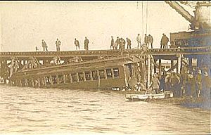
A sad train accident happened on October 28, 1906. Three train cars went off a bridge into 30 feet of water. This happened in Beach Thorofare. 53 people died.
As cars became popular, roads improved. The first road bridge to Atlantic City opened in 1905. It used Albany Avenue, which is now part of US 40/US 322. In 1916, New Jersey Route 152 opened between Somers Point and Longport.
In 1919, the White Horse Pike (US 30) was finished. It connected Atlantic City to Camden. The Harding Highway (US 40) opened in 1922. The Black Horse Pike (US 322) opened in 1935.
The Great Egg Harbor Bridge opened in 1956. This completed the Garden State Parkway, a major highway. In 1964, the Atlantic City Expressway opened. It connected the Parkway to Camden County. In 2001, the Atlantic City–Brigantine Connector was built. It connects the Expressway to Atlantic City's marina area.
Roads and highways
As of 2017, Atlantic County had 1,984 miles of public roads. Local towns maintained 1,395 miles. The county maintained 373 miles. The state and other authorities maintained the rest.
Major highways
Important roads in Atlantic County include:
- Garden State Parkway (21.5 miles in the county)
- Atlantic City Expressway (29.6 miles)
- U.S. Route 9
- U.S. Route 30
- U.S. Route 40
- U.S. Route 206
- U.S. Route 322
- Route 49
- Route 50
- Route 52
- Route 54
- Route 87
- Route 152
Public transportation
NJ Transit's Atlantic City Line connects Atlantic City to Philadelphia. It stops at stations in Hammonton, Egg Harbor City, and Absecon within Atlantic County.
Images for kids
See also
 In Spanish: Condado de Atlantic para niños
 | Janet Taylor Pickett |
 | Synthia Saint James |
 | Howardena Pindell |
 | Faith Ringgold |


