Herkimer County, New York facts for kids
Quick facts for kids
Herkimer County
|
|||
|---|---|---|---|
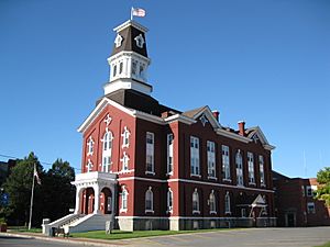
Herkimer County Courthouse
|
|||
|
|||
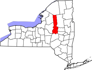
Location within the U.S. state of New York
|
|||
 New York's location within the U.S. |
|||
| Country | |||
| State | |||
| Founded | 1791 | ||
| Named for | Nicholas Herkimer | ||
| Seat | Herkimer | ||
| Largest town | German Flatts | ||
| Area | |||
| • Total | 1,458 sq mi (3,780 km2) | ||
| • Land | 1,411 sq mi (3,650 km2) | ||
| • Water | 46 sq mi (120 km2) 3.2% | ||
| Population
(2020)
|
|||
| • Total | 60,139 | ||
| • Density | 42.6/sq mi (16.4/km2) | ||
| Time zone | UTC−5 (Eastern) | ||
| • Summer (DST) | UTC−4 (EDT) | ||
| Congressional district | 21st | ||
Herkimer County is a county located in the state of New York, USA. In 2020, about 60,139 people lived there. The main town, or county seat, is Herkimer.
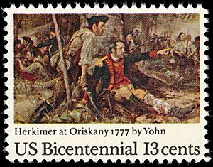
The county was formed in 1791. It was created from a part of Montgomery County, located north of the Mohawk River. Herkimer County is named after General Nicholas Herkimer. He was a hero who fought in the American Revolutionary War. He was badly wounded in the Battle of Oriskany in 1777 and later died. This area is part of the Mohawk Valley region of New York. Herkimer County is also part of the Utica–Rome Metropolitan Statistical Area.
Contents
History of Herkimer County
Herkimer County was established in 1791. This happened after the American Revolutionary War when New York State was growing. It was one of three new counties made from Montgomery County. The other two were Otsego and Tioga counties.
At first, Herkimer County was much larger than it is today. Over time, its size became smaller. This happened as new counties were created in New York.
Land Sales and New Counties
A part of Herkimer County was included in something called Macomb's Purchase in 1791. This was a huge sale of public lands. It happened after the state gained land from Iroquois tribes. These tribes had sided with the British during the war. Suddenly, New York State was selling millions of acres of land. This land was in upstate, central, and western New York.
Several new counties were later formed from parts of Herkimer County:
- In 1794, Onondaga County was created. This new county was also larger than it is now. It included areas that are now Cayuga, Cortland, and part of Oswego counties.
- In 1798, parts of Herkimer and Tioga counties were used to form Chenango County.
- Another part of Herkimer County was used to create Oneida County. This county was also larger at first. It included areas that are now Jefferson, Lewis, and part of Oswego counties.
- In 1802, parts of Herkimer, Clinton, and Montgomery counties were combined. They formed the new St. Lawrence County.
Farming and Industry
The economy in Herkimer County first focused on general farming. Then, it became known for growing wheat. However, after the Erie Canal opened, farmers in Herkimer found it hard to compete. Farmers to the west could send their grain more easily.
By the mid-1800s, Herkimer farmers started specializing in dairy farming. They became famous for their cheese. This cheese was sold in places like New York City.
During the American Civil War, Herkimer County played a part. Five companies of soldiers from Herkimer joined the 34th New York Volunteer Infantry Regiment. This unit was even nicknamed "The Herkimer Regiment."
Geography of Herkimer County
Herkimer County covers a total area of about 1,458 square miles. Most of this is land, about 1,411 square miles. The rest, about 46 square miles, is water. This means about 3.2% of the county is water.
Neighboring Counties
Herkimer County shares borders with these other counties:
- St. Lawrence County - to the north
- Hamilton County - to the northeast
- Fulton County - to the east
- Montgomery County - to the southeast
- Otsego County - to the south
- Oneida County - to the west
- Lewis County - to the northwest
Herkimer County is in central New York State. It is northwest of Albany and east of Syracuse. The northern part of the county is inside the Adirondack Park. The Mohawk River flows through the southern part of the county. Herkimer County is actually larger than the entire State of Rhode Island!
Population and People
Here's how the population of Herkimer County has changed over the years:
| Historical population | |||
|---|---|---|---|
| Census | Pop. | %± | |
| 1800 | 14,479 | — | |
| 1810 | 22,046 | 52.3% | |
| 1820 | 31,017 | 40.7% | |
| 1830 | 35,870 | 15.6% | |
| 1840 | 37,477 | 4.5% | |
| 1850 | 38,244 | 2.0% | |
| 1860 | 40,561 | 6.1% | |
| 1870 | 39,929 | −1.6% | |
| 1880 | 42,669 | 6.9% | |
| 1890 | 45,608 | 6.9% | |
| 1900 | 51,049 | 11.9% | |
| 1910 | 56,356 | 10.4% | |
| 1920 | 64,962 | 15.3% | |
| 1930 | 64,006 | −1.5% | |
| 1940 | 59,527 | −7.0% | |
| 1950 | 61,407 | 3.2% | |
| 1960 | 66,370 | 8.1% | |
| 1970 | 67,633 | 1.9% | |
| 1980 | 66,714 | −1.4% | |
| 1990 | 65,797 | −1.4% | |
| 2000 | 64,427 | −2.1% | |
| 2010 | 64,519 | 0.1% | |
| 2020 | 60,139 | −6.8% | |
| U.S. Decennial Census 1790–1960 1900–1990 1990–2000 2010–2020 |
|||
2020 Census Information
The 2020 Census collected information about the people living in Herkimer County. Here's a look at the different groups:
| Race | Number | Percentage |
|---|---|---|
| White (not Hispanic) | 54,653 | 90.1% |
| Black or African American (not Hispanic) | 682 | 1.13% |
| Native American (not Hispanic) | 76 | 0.12% |
| Asian (not Hispanic) | 359 | 0.6% |
| Pacific Islander (not Hispanic) | 32 | 0.05% |
| Other/Mixed (not Hispanic) | 2,807 | 4.7% |
| Hispanic or Latino | 1,530 | 2.54% |
Economy and Resources
Herkimer County is famous for special quartz crystals. These crystals are very clear and have points on both ends. They are called Herkimer diamonds because they look a bit like real diamonds. You can find them in the county, and that's how they got their name!
Education in Herkimer County
Herkimer County Community College is a college located in the Village of Herkimer. It offers higher education to students.
Many school districts serve the children of Herkimer County:
- Adirondack Central School District
- Central Valley School District
- Dolgeville Central School District
- Fort Plain Central School District
- Frankfort-Schuyler Central School District
- Herkimer Central School District
- Holland Patent Central School District
- Little Falls City School District
- Mount Markham Central School District
- New Hartford Central School District
- Oppenheim-Ephratah-St. Johnsville Central School District
- Poland Central School District
- Remsen Central School District
- Richfield Springs Central School District
- Sauquoit Valley Central School District
- Town of Webb Union Free School District
- Van Hornesville-Owen D. Young Central School District
- West Canada Valley Central School District
- Whitesboro Central School District
Transportation in Herkimer County
Air Travel
Herkimer County has one public airport. It is called Frankfort-Highland Airport (6B4) and is located in Frankfort.
Train Service
Passenger train service is available nearby in Utica. This service is provided by Amtrak. In the past, trains like the North Shore Limited used to stop at Little Falls. Trains also ran through Thendara in the northern part of the county until 1965.
Roads and Highways
Major roads run through Herkimer County. Interstate 90, which is part of the New York State Thruway, goes east-west through the southern part of the county. New York State Route 5 also runs through this area. State Route 28 travels north-south through the county.
Communities of Herkimer County
Larger Towns and Villages
Here are some of the larger settlements in Herkimer County:
| # | Location | Population | Type | Area |
|---|---|---|---|---|
| 1 | Ilion | 8,053 | Village | Canalside |
| 2 | †Herkimer | 7,743 | Village | Canalside |
| 3 | Little Falls | 4,946 | City | Canalside |
| 4 | Mohawk | 2,731 | Village | Canalside |
| 5 | Frankfort | 2,598 | Village | Canalside |
| 6 | ‡Dolgeville | 2,206 | Village | Center |
| 7 | West Winfield | 826 | Village | South |
| 8 | Old Forge | 756 | CDP | Adirondack Park |
| 9 | Middleville | 512 | Village | Center |
| 10 | Poland | 508 | Village | Center |
| 11 | Cold Brook | 329 | Village | Center |
| - | Eagle Bay | N/A | CDP | Adirondack Park |
| - | East Frankfort | N/A | CDP | Canalside |
| - | East Herkimer | N/A | CDP | Canalside |
| - | Salisbury Center | N/A | CDP | Center |
| - | South Ilion | N/A | CDP | Canalside |
| - | Thendara | N/A | CDP | Adirondack Park |
Towns in Herkimer County
Small Villages and Hamlets
- Beaver River
- Jordanville
- Newville
See also
 In Spanish: Condado de Herkimer para niños
 | Calvin Brent |
 | Walter T. Bailey |
 | Martha Cassell Thompson |
 | Alberta Jeannette Cassell |


