
List of fjords in Canada facts for kids
A fjord is a long, narrow arm of the sea. It has very steep sides, like a deep valley. Fjords are created by glaciers that slowly carve out the land over thousands of years. Imagine a giant ice river pushing its way through mountains!
A fjord can have deep parts, like bowls, and shallower parts called sills. These sills are like underwater ridges that separate the deeper sections. The deep bowls can be from 20 to 500 meters deep. The sills might be just a few meters below the water's surface.
Canada has many fjords, especially along its coastlines.
Contents
- Where to Find Fjords in Canada
- When Cliffs Fall: The Risk of Tsunamis
- Long and Winding Fjords
- Fjords and Climate Change
- Why Some Fjords Are Called "Canals" or "Channels"
- Skookumchucks: Strong Waters
- Powerful Winds in Fjords
- Fjord Lakes: Freshwater Wonders
- List of Fjords in Canada
- Images for kids
- See also
Where to Find Fjords in Canada
Canada is home to many amazing fjords. You can find them in different parts of the country.
British Columbia's Fjords
The British Columbia Coast has many fjords. They stretch from the border with Alaska all the way to Indian Arm. Kingcome Inlet is a great example of a fjord on the west coast.
Fjords in Newfoundland and Labrador
In Newfoundland and Labrador, you'll find fjords like Saglek Fiord, Nachvak Fiord, and Hebron Fiord in Labrador. On the island of Newfoundland, Western Brook Pond, Trout River Big Pond, and Bonne Bay in Gros Morne National Park are also along the coast.
Quebec's Saguenay Fjord
Quebec has its own famous fjord. The Saguenay River valley is home to the Saguenay Fjord. It's about 100 kilometers long and 275 meters deep.
Arctic Fjords
The Arctic Archipelago also has fjords. You can see them around Ellesmere and Baffin Island. Examples include Alexandra Fiord on Ellesmere Island and Kangiqtualuk Uqquqti on Baffin Island.
When Cliffs Fall: The Risk of Tsunamis
Sometimes, a large piece of a high cliff wall can break off and fall into a fjord. This can create a huge wave called a tsunami. This happened in the early 1900s at Western Brook Pond in Gros Morne National Park. A part of the cliff called Broke Off Cliff fell, causing a 30-meter-high tsunami!
Long and Winding Fjords
Some fjords are very complex. They have many waterways that connect, making them very long. For example, Dean Channel and Douglas Channel are long fjords.
In 1894, Norwegian immigrants settled in Hagensborg. This town is in the Bella Coola Valley within the Dean Channel fjord. The area reminded them of their home country, Norway, which is famous for its fjords. The Dean Channel fjord, from its start to the Fitz Hugh Sound, is about 170 kilometers long. This makes it almost as long as Norway's Hardangerfjord, which is 179 kilometers long. The Hardangerfjord is one of the longest fjords in the world!
Fjords and Climate Change
Fjords like Anaktalak Bay, Saglek Fiord, and Nachvak Fiord in Newfoundland and Labrador are being studied. Scientists are looking at how global warming is changing them. Things like more tourists, more boats, and pollution from air or industry are affecting these beautiful waters. Even changing weather patterns are having an impact on these once untouched fjord basins.
Why Some Fjords Are Called "Canals" or "Channels"
On the British Columbia and Southeast Alaskan coasts, some fjords or inlets are called "canals." This name comes from the Spanish expeditions to the Pacific Northwest in the 1700s. For example, Haro Strait was originally called Canal de Haro. The English word "channel" is similar to the Spanish "canal." You can see this in names like Dean Channel.
Skookumchucks: Strong Waters
Some fjords on the British Columbia coast have fast-moving water called "rapids." These are known as skookumchucks. This word means "strong waters" in Chinook Jargon. Skookumchucks happen when the deep water inside a fjord rushes through shallow and narrow areas near its mouth.
Powerful Winds in Fjords
Fjords in Canada and Norway can experience strong winds called mountain-gap winds or squamish winds. These winds are also known as "outflow winds." They happen when cold, dry air from inland areas finds an easy path through the fjord valleys. These winds can be as strong as hurricane-force winds!
Fjord Lakes: Freshwater Wonders
Not all "fjords" are connected to the sea. Western Brook Pond and Trout River Big Pond in Newfoundland's Gros Morne National Park are often called fjords. However, they are actually freshwater lakes that were cut off from the ocean a long time ago. So, they are not true fjords in the English meaning of the word. These types of lakes are sometimes called "fjord lakes."
It's interesting to know that Pissing Mare Falls, which is 350 meters high, flows into Western Brook Pond. In British Columbia, Owikeno Lake is another notable fjord-lake. It's a freshwater part of Rivers Inlet.
List of Fjords in Canada
| Image | Fjords | Province | Co-ordinates | Comments |
|---|---|---|---|---|
| Aarrujaaqtuup Kangiqtua | NU | 68°58′17″N 68°32′33″W / 68.97139°N 68.54250°W | Inuktitut syllabics: ᐋᕐᕈᔮᖅᑑᑉ ᑲᖏᖅᑐᐊ, Aarrujaaqtuup Kangiqtua (formerly Pitchforth Fiord) | |
| Agate Fiord | NU | 79°27′00″N 93°00′00″W / 79.45000°N 93.00000°W | ||
| Akpait Fiord | NU | 66°53′19″N 61°53′34″W / 66.88861°N 61.89278°W | ||
| Aktijartukan Fiord | NU | 65°06′00″N 63°55′00″W / 65.10000°N 63.91667°W | ||
| Alan Reach | BC | 53°27′59″N 128°37′20″W / 53.46639°N 128.62222°W | ||
 |
Alberni Inlet | BC | 49°03′34″N 124°50′57″W / 49.05944°N 124.84917°W | Length 40 km |
 |
Alexandra Fiord | NU | 70°54′00″N 76°00′00″W / 70.90000°N 76.00000°W | |
| Alice Arm | BC | 55°27′03″N 129°35′19″W / 55.45083°N 129.58861°W | ||
| Alluviaq Fiord | NU | 59°29′45″N 65°09′05″W / 59.49583°N 65.15139°W | Alluviaq Fiord / Fjord Alluviaq (formerly Abloviak Bay / Abloviak Fiord / Fjord Abloviak) | |
| Archer Fiord | NU | 81°25′00″N 67°00′00″W / 81.41667°N 67.00000°W | ||
| Arthur Fiord | NU | 76°30′00″N 93°24′00″W / 76.50000°N 93.40000°W | ||
| Arviqtujuq Kangiqtua | NU | 70°42′02″N 69°57′15″W / 70.70056°N 69.95417°W | Arviqtujuq Kangiqtua (formerly Eglinton Fiord) | |
| Aurland Fiord | NU | 81°04′00″N 94°25′00″W / 81.06667°N 94.41667°W | ||
 |
Ayles Fiord | NU | 82°45′00″N 80°00′00″W / 82.75000°N 80.00000°W | |
| Baad Fiord | NU | 76°28′00″N 86°30′00″W / 76.46667°N 86.50000°W | ||
| Baie Wakeham | QC | 61°37′30″N 71°59′00″W / 61.62500°N 71.98333°W | Wakeham Bay | |
| Bals Fiord | NU | 80°24′00″N 95°45′00″W / 80.40000°N 95.75000°W | ||
| Barrie Reach | BC | 53°27′36″N 128°15′51″W / 53.46000°N 128.26417°W | ||
| Baumann Fiord | NU | 77°40′00″N 85°35′00″W / 77.66667°N 85.58333°W | ||
| Bay Fiord | NU | 78°55′00″N 83°30′00″W / 78.91667°N 83.50000°W | ||
| Bears Gut | NL | 58°42′37″N 63°00′29″W / 58.71028°N 63.00806°W | ||
| Beitstad Fiord | NU | 79°04′00″N 78°10′00″W / 79.06667°N 78.16667°W | ||
| Belize Inlet | BC | 51°07′52″N 127°16′51″W / 51.13111°N 127.28083°W | A part of the fjord network Seymour-Belize Inlet Complex (SBIC), located on the north coast of British Columbia. Belize Inlet, which is 50 km in length has its own side inlets, narrow waterways named Wentworth Sound and Alison Sound. | |
| Bentham Fiord | NU | 77°08′00″N 80°12′00″W / 77.13333°N 80.20000°W | ||
| Bird Fiord | NU | 77°10′00″N 87°00′00″W / 77.16667°N 87.00000°W | ||
| Blind Fiord | NU | 78°14′00″N 86°16′00″W / 78.23333°N 86.26667°W | ||
| Blue Fiord | NU | 77°16′00″N 87°05′00″W / 77.26667°N 87.08333°W | ||
| Boas Fiord | NU | 66°48′00″N 62°49′00″W / 66.80000°N 62.81667°W | ||
 |
Bonne Bay | NL | 49°33′12″N 57°55′53″W / 49.55333°N 57.93139°W | There is both Inner Bonne Bay and outer Bonne Bay. Outer Bonne Bay opens up to the entrance of the fjord of Bonne Bay. |
 |
Borup Fiord | NU | 80°37′00″N 83°25′00″W / 80.61667°N 83.41667°W | |
| Briggs Inlet | BC | 52°24′33″N 127°59′31″W / 52.40917°N 127.99194°W | ||
| Bukken Fiord | NU | 80°43′00″N 94°55′00″W / 80.71667°N 94.91667°W | ||
| Bunde Fiord | NU | 80°36′00″N 94°55′00″W / 80.60000°N 94.91667°W | ||
| Burke Channel | BC | 52°09′14″N 127°27′48″W / 52.15389°N 127.46333°W | See also the major inlets of British Columbia coast, and Dean Channel. | |
 |
Burrard Inlet | BC | 49°17′55″N 123°05′07″W / 49.29861°N 123.08528°W | Burrard Inlet is a coastal fjord in southwestern British Columbia. The City of Vancouver and nearby cities are on its shores. This makes the fjord very busy with ships from the Port of Vancouver. |
 |
Bute Inlet | BC | 50°39′09″N 124°53′10″W / 50.65250°N 124.88611°W | |
| Cambridge Fiord | NU | 71°26′00″N 74°45′00″W / 71.43333°N 74.75000°W | ||
| Cañon Fiord | NU | 80°00′00″N 82°35′00″W / 80.00000°N 82.58333°W | ||
| Cascade Inlet | BC | 52°30′04″N 127°31′19″W / 52.50111°N 127.52194°W | ||
| Chandler Fiord | NU | 81°38′00″N 68°46′00″W / 81.63333°N 68.76667°W | ||
| Chief Mathews Bay | BC | 53°21′32″N 128°04′59″W / 53.35889°N 128.08306°W | See also the major inlets of British Columbia coast. | |
| Clark Fiord | NU | 70°58′00″N 72°07′00″W / 70.96667°N 72.11667°W | ||
 |
Clearwater Fiord | NU | 66°34′00″N 67°27′00″W / 66.56667°N 67.45000°W | |
| Confederation Fiord | NU | 68°10′00″N 67°19′00″W / 68.16667°N 67.31667°W | ||
| Conybeare Fiord | NU | 81°34′00″N 67°35′00″W / 81.56667°N 67.58333°W | ||
| Coronation Fiord | NU | 67°14′00″N 64°35′00″W / 67.23333°N 64.58333°W | ||
| Cousins Inlet | BC | 52°19′10″N 127°45′05″W / 52.31944°N 127.75139°W | ||
| d'Iberville Fiord | NU | 80°34′00″N 79°00′00″W / 80.56667°N 79.00000°W | ||
.jpg) |
Dean Channel | BC | 52°28′44″N 127°14′22″W / 52.47889°N 127.23944°W | The total length of the fjord from the head of Dean Channel to the mouth of Fitz Hugh Sound is about 170 km, almost as long as Hardangerfjord in Norway. |
| Denmark Fiord | NU | 70°35′00″N 103°05′00″W / 70.58333°N 103.08333°W | ||
 |
Desolation Sound | BC | 50°07′20″N 124°45′30″W / 50.12222°N 124.75833°W | See also the major inlets of British Columbia coast, Desolation Sound Marine Provincial Park and Recreation Park. |
| Devastation Channel | BC | 53°40′09″N 128°50′09″W / 53.66917°N 128.83583°W | ||
| Dexterity Fiord | NU | 71°15′00″N 73°02′00″W / 71.25000°N 73.03333°W | ||
 |
Disraeli Fiord | NU | 82°49′00″N 73°21′00″W / 82.81667°N 73.35000°W | Disraeli Fiord (formerly Disraeli Bay) |
.jpg) |
Douglas Channel | BC | 53°40′00″N 129°08′00″W / 53.66667°N 129.13333°W | Length 90 km |
| East Fiord | NU | 79°24′00″N 93°20′00″W / 79.40000°N 93.33333°W | ||
| Eids Fiord | NU | 77°21′10″N 87°06′00″W / 77.35278°N 87.10000°W | ||
| Eidsbotn | NU | 76°09′55″N 91°00′00″W / 76.16528°N 91.00000°W | ||
| Ekalugad Fiord | NU | 68°46′00″N 68°37′00″W / 68.76667°N 68.61667°W | ||
| Ekortiarsuk Fiord | NL | 59°59′33″N 64°22′23″W / 59.99250°N 64.37306°W | ||
| Emma Fiord | NU | 81°29′00″N 89°00′00″W / 81.48333°N 89.00000°W | ||
| Ephemeral Cove | NU | 63°27′40″N 91°06′40″W / 63.46111°N 91.11111°W | ||
| Europa Reach | BC | 53°26′25″N 128°25′26″W / 53.44028°N 128.42389°W | See also list of rivers of British Columbia and British Columbia Coast | |
| Exaluin Fiord | NU | 65°40′00″N 62°54′00″W / 65.66667°N 62.90000°W | ||
| Expedition Fiord | NU | 79°20′00″N 92°00′00″W / 79.33333°N 92.00000°W | ||
| Fabricius Fiord | NU | 72°22′00″N 84°38′00″W / 72.36667°N 84.63333°W | ||
| Fisher Channel | BC | 52°05′09″N 127°53′16″W / 52.08583°N 127.88778°W | Fisher Channel leads into Dean Channel, and towards Ocean Falls. | |
 |
Fitz Hugh Sound | BC | 51°40′30″N 127°55′05″W / 51.67500°N 127.91806°W | See also Dean Channel. |
| Fjord Alluviaq | QC | 59°26′45″N 65°09′58″W / 59.44583°N 65.16611°W | Alluviaq Fiord / Fjord Alluviaq (formerly Abloviak Bay / Abloviak Fiord / Fjord Abloviak) | |
| Fjord de Salluit | QC | 62°12′44″N 75°41′43″W / 62.21222°N 75.69528°W | ||
 |
Fjord du Saguenay | QC | 48°07′54″N 69°43′36″W / 48.13167°N 69.72667°W | Southernmost fjord in Canada. |
| Fjord Qanartalik | QC | 61°50′53″N 72°37′41″W / 61.84806°N 72.62806°W | ||
| Fjord Qasigiarsiti | QC | 59°01′34″N 65°43′10″W / 59.02611°N 65.71944°W | ||
| Fjord Tursukattaq | QC | 61°51′07″N 72°43′42″W / 61.85194°N 72.72833°W | ||
| Foss Fiord | NU | 70°22′00″N 87°00′00″W / 70.36667°N 87.00000°W | ||
| Fram Fiord | NU | 76°31′00″N 81°19′00″W / 76.51667°N 81.31667°W | ||
 |
Frederick Sound | BC | 51°02′10″N 126°43′10″W / 51.03611°N 126.71944°W | The largest branch of Seymour Inlet. |
 |
Gardner Canal | BC | 53°26′35″N 128°23′30″W / 53.44306°N 128.39167°W | Technically a side-inlet of the larger Douglas Channel. The Gardner is a principal inlet/fjord of a length 90 km. |
| Gibbs Fiord | NU | 70°49′15″N 71°54′50″W / 70.82083°N 71.91389°W | ||
| Gibs Fiord | NU | 79°53′00″N 87°15′00″W / 79.88333°N 87.25000°W | ||
| Gifford Fiord | NU | 70°10′00″N 82°30′00″W / 70.16667°N 82.50000°W | ||
| Gilttoyees Inlet | BC | 53°50′09″N 128°58′24″W / 53.83583°N 128.97333°W | ||
| Glacier Fiord | NU | 78°22′00″N 89°29′00″W / 78.36667°N 89.48333°W | ||
| Goose Fiord | NU | 76°36′00″N 88°35′00″W / 76.60000°N 88.58333°W | ||
| Greely Fiord | NU | 80°30′00″N 81°40′00″W / 80.50000°N 81.66667°W | ||
 |
Grise Fiord | NU | 76°35′00″N 83°14′00″W / 76.58333°N 83.23333°W | There is a hamlet of the same name, Grise Fiord on this fiord. Grise Fiord means "pig fiord" and in Inuktitut is named Ausuittuq. |
| Haakon Fiord | NU | 78°50′00″N 100°45′00″W / 78.83333°N 100.75000°W | ||
| Harbour Fiord | NU | 76°31′00″N 84°08′00″W / 76.51667°N 84.13333°W | ||
| Hare Fiord | NU | 81°01′00″N 85°30′00″W / 81.01667°N 85.50000°W | ||
| Hastings Arm | BC | 55°30′14″N 129°46′04″W / 55.50389°N 129.76778°W | ||
| Hayes Fiord | NU | 79°02′00″N 76°45′00″W / 79.03333°N 76.75000°W | ||
| Hebron Fiord | NL | 58°08′49″N 62°52′50″W / 58.14694°N 62.88056°W | See also Torngat Mountains | |
 |
Hotham Sound | BC | 49°52′05″N 124°02′23″W / 49.86806°N 124.03972°W | See also the major inlets of British Columbia coast, Nelson Island and St. Vincent Bay. |
| Hevenor Inlet K’t’a’i |
BC | 53°38′28″N 129°59′17″W / 53.64111°N 129.98806°W | See also Pitt Island | |
 |
Howe Sound | BC | 49°30′00″N 123°19′00″W / 49.50000°N 123.31667°W | Howe Sound is a roughly triangular-shaped complex of fjords. The scenic Sea-to-Sky Highway runs along the eastern shore of the sound. |
 |
Humber Arm | NL | 49°00′07″N 58°05′29″W / 49.00194°N 58.09139°W | |
| Ikkudliayuk Fiord | NL | 60°04′18″N 64°29′59″W / 60.07167°N 64.49972°W | ||
 |
Indian Arm | BC | 49°22′37″N 122°52′41″W / 49.37694°N 122.87806°W | Indian Arm Provincial Park protects the area of Indian Arm fjord. |
| Ingnit Fiord | NU | 65°48′00″N 62°40′00″W / 65.80000°N 62.66667°W | ||
| Inugsuin Fiord | NU | 69°53′40″N 69°15′00″W / 69.89444°N 69.25000°W | ||
| Iqalualuit Fiord | NU | 68°35′00″N 68°35′00″W / 68.58333°N 68.58333°W | ||
| Iqalujjuaq Fiord | NU | 65°40′00″N 65°05′00″W / 65.66667°N 65.08333°W | ||
| Isortoq Fiord | NU | 69°55′00″N 77°05′00″W / 69.91667°N 77.08333°W | Iterungnek Fiord (formerly Jerusalem Bay) | |
| Iterungnek Fiord | NL | 58°15′18″N 62°48′31″W / 58.25500°N 62.80861°W | ||
| Itirbilung Fiord | NU | 69°18′00″N 68°40′00″W / 69.30000°N 68.66667°W | ||
 |
Jervis Inlet | BC | 49°55′25″N 123°58′27″W / 49.92361°N 123.97417°W | Jervis Inlet is 90 km in length. Between Toba Inlet and Jervis Inlet to its west, however, there is a freshwater fjord, Powell Lake. |
| Jokel Fiord | NU | 78°52′00″N 78°05′00″W / 78.86667°N 78.08333°W | ||
| Jugeborg Fiord | NU | 81°14′10″N 89°30′00″W / 81.23611°N 89.50000°W | ||
| Kairolik Fiord | NU | 65°31′00″N 63°31′00″W / 65.51667°N 63.51667°W | ||
| Kangalaksiorvik Fiord | NL | 59°24′05″N 63°56′27″W / 59.40139°N 63.94083°W | ||
| Kangerk Fiord | NU | 66°23′00″N 67°18′00″W / 66.38333°N 67.30000°W | ||
| Kangilo Fiord | NU | 66°18′00″N 67°36′00″W / 66.30000°N 67.60000°W | ||
 |
Kangiqhuk | NU | 69°06′23″N 105°09′26″W / 69.10639°N 105.15722°W | Kangiqhuk (formerly West Arm) |
| Kangiqtualuk Agguqti | NU | 70°30′46″N 71°37′55″W / 70.51278°N 71.63194°W | Kangiqtualuk Agguqti (formerly Walker Arm) | |
 |
Kangiqtualuk Uqquqti | NU | 70°43′51″N 70°43′53″W / 70.73083°N 70.73139°W | Kangiqtualuk Uqquqti (formerly Sam Ford Fiord) |
 |
Kangiqtugaapik | NU | 70°14′37″N 68°57′37″W / 70.24361°N 68.96028°W | Kangiqtugaapik (formerly Clyde Inlet) |
| Kangiqtugaapiruluk | NU | 67°05′37″N 63°34′18″W / 67.09361°N 63.57167°W | Inuktitut syllabics: ᑲᖏᖅᑐᒑᐱᕈᓗᒃ, Kangiqtugaapiruluk (formerly Kangert Fiord) | |
| Kangiqturuluk | NU | 68°37′55″N 68°39′09″W / 68.63194°N 68.65250°W | Inuktitut syllabics: ᑲᖏᖅᑐᕈᓗᒃ, Kangiqturuluk (formerly Kangok Fiord) | |
| Kangirlugag Fiord | NU | 68°48′00″N 68°10′00″W / 68.80000°N 68.16667°W | ||
| Kangirtukutaaruluq Fiord | NU | 67°41′40″N 64°29′10″W / 67.69444°N 64.48611°W | ||
 |
Khutzeymateen Inlet | BC | 54°39′43″N 130°04′18″W / 54.66194°N 130.07167°W | |
| Kiltuish Inlet | BC | 53°21′57″N 128°29′39″W / 53.36583°N 128.49417°W | ||
| Kingcome Inlet | BC | 50°57′00″N 126°12′00″W / 50.95000°N 126.20000°W | A lesser principal fjord of the British Columbia Coast. | |
| Kingnait Fiord | NU | 66°02′45″N 64°57′30″W / 66.04583°N 64.95833°W | ||
| Kingnelling Fiord | NU | 67°27′10″N 64°15′20″W / 67.45278°N 64.25556°W | ||
| Kitimat Arm | BC | 53°52′37″N 128°45′44″W / 53.87694°N 128.76222°W | See also Douglas Channel and Kitimat River. | |
 |
Knight Inlet | BC | 50°41′01″N 125°52′29″W / 50.68361°N 125.87472°W | Knight Inlet is one of the longest great saltwater inlets/fjords on the BC Coast at about 125 km in length; it is about 2.5 km in average width. |
| Komaktorvik Fiord | NL | 59°17′01″N 63°43′57″W / 59.28361°N 63.73250°W | ||
| Kulutingwak Fiord | NU | 82°07′00″N 82°48′00″W / 82.11667°N 82.80000°W | ||
| Kumlien Fiord | NU | 65°24′00″N 64°45′00″W / 65.40000°N 64.75000°W | Kumlien Fiord (formerly Kumlein Fiord) | |
| Kwatna Inlet | BC | 52°05′34″N 127°27′45″W / 52.09278°N 127.46250°W | See also Dean Channel. | |
.jpg) |
Kyuquot Sound | BC | 50°03′00″N 127°15′00″W / 50.05000°N 127.25000°W | |
| Labouchere Channel | BC | 52°23′36″N 127°12′54″W / 52.39333°N 127.21500°W | See also North Bentinck Arm, King Island, and Dean Channel. | |
| Li Fiord | NU | 80°05′00″N 95°25′00″W / 80.08333°N 95.41667°W | ||
| Livingstone Fiord | NU | 66°03′00″N 67°45′00″W / 66.05000°N 67.75000°W | ||
| Loughborough Inlet | BC | 50°34′45″N 125°32′28″W / 50.57917°N 125.54111°W | Loughborough Inlet is a lesser principal inlet/fjord with a length of 35 km and a width of 2.5 km. | |
| Louise Fiord | NU | 78°58′00″N 102°36′00″W / 78.96667°N 102.60000°W | ||
 |
Maktak Fiord | NU | 67°18′45″N 64°22′45″W / 67.31250°N 64.37917°W | |
| Markham Fiord | NU | 82°58′50″N 71°28′00″W / 82.98056°N 71.46667°W | ||
| Maujatuuq Fiord | NU | 67°43′50″N 64°48′50″W / 67.73056°N 64.81389°W | ||
| McBeth Fiord | NU | 69°32′20″N 69°10′00″W / 69.53889°N 69.16667°W | McBeth Fiord (formerly Ijellirtung Fiord) | |
| Mermaid Fiord | NU | 66°14′00″N 62°44′00″W / 66.23333°N 62.73333°W | ||
| Middle Fiord | NU | 79°37′00″N 95°00′00″W / 79.61667°N 95.00000°W | ||
| Milne Fiord | NU | 82°38′00″N 81°27′00″W / 82.63333°N 81.45000°W | ||
| Mokka Fiord | NU | 79°35′00″N 87°15′00″W / 79.58333°N 87.25000°W | ||
| Mooneshine Fiord | NU | 66°25′00″N 61°47′00″W / 66.41667°N 61.78333°W | ||
| Muskox Fiord | NU | 76°30′00″N 87°27′00″W / 76.50000°N 87.45000°W | ||
 |
Nachvak Fiord | NL | 59°02′09″N 63°44′52″W / 59.03583°N 63.74778°W | |
| Najjuttuuq Fiord | NU | 68°49′20″N 69°16′35″W / 68.82222°N 69.27639°W | ||
| Nallulik Fiord | NU | 69°13′00″N 68°45′00″W / 69.21667°N 68.75000°W | ||
| Nallussiaq Fiord | NU | 65°39′00″N 63°33′00″W / 65.65000°N 63.55000°W | ||
| Narpaing Fiord | NU | 67°48′00″N 65°33′00″W / 67.80000°N 65.55000°W | ||
 |
Narrows Inlet | BC | 49°42′40″N 123°46′47″W / 49.71111°N 123.77972°W | Narrows Inlet (formerly Narrows Arm) |
| Nass Bay | BC | 54°59′23″N 129°59′54″W / 54.98972°N 129.99833°W | ||
| Nedlukseak Fiord | NU | 67°55′00″N 66°22′00″W / 67.91667°N 66.36667°W | ||
| Nenahlmai Lagoon | BC | 50°58′46″N 127°12′15″W / 50.97944°N 127.20417°W | ||
| Nettilling Fiord | NU | 66°02′00″N 68°12′00″W / 66.03333°N 68.20000°W | ||
| Newton Fiord | NU | 63°05′00″N 66°08′00″W / 63.08333°N 66.13333°W | ||
| Noodleook Fiord | NL | 59°55′51″N 64°24′12″W / 59.93083°N 64.40333°W | ||
.jpg) |
North Bentinck Arm | BC | 52°21′40″N 126°53′33″W / 52.36111°N 126.89250°W | See also South Bentinck Arm. North Bentinck Arm is a deep fjord which runs about 15 km in length and is about 2.3 km in width. The fjord has a depth of between 200 and 400 m. |
| North Fiord | NU | 79°56′00″N 96°25′00″W / 79.93333°N 96.41667°W | ||
| North Pangnirtung Fiord | NU | 67°09′00″N 64°17′00″W / 67.15000°N 64.28333°W | ||
| Nudlung Fiord | NU | 68°21′00″N 67°27′00″W / 68.35000°N 67.45000°W | ||
| Nugent Sound | BC | 51°05′20″N 127°18′15″W / 51.08889°N 127.30417°W | Located between Belize Inlet and Seymour Inlet. | |
| Nyeboe Fiord | NU | 70°25′00″N 86°30′00″W / 70.41667°N 86.50000°W | ||
| Observatory Inlet | BC | 55°17′25″N 129°46′59″W / 55.29028°N 129.78306°W | ||
| Otto Fiord | NU | 81°02′00″N 87°00′00″W / 81.03333°N 87.00000°W | ||
| Owikeno Lake | BC | 51°40′07″N 126°49′45″W / 51.66861°N 126.82917°W | ||
| Padle Fiord | NU | 66°55′00″N 63°25′00″W / 66.91667°N 63.41667°W | ||
 |
Pangnirtung Fiord | NU | 66°12′13″N 65°37′35″W / 66.20361°N 65.62639°W | |
| Pearse Canal | BC | 54°53′54″N 130°23′33″W / 54.89833°N 130.39250°W | Pearse Canal forms the border between British Columbia and the southernmost point of the Alaska Panhandle. | |
.jpg) |
Portland Canal | BC | 55°27′00″N 130°02′00″W / 55.45000°N 130.03333°W | Portland Canal is 114.6 km in length. |
 |
Portland Inlet | BC | 54°50′51″N 130°12′55″W / 54.84750°N 130.21528°W | Portland Inlet is 40 km long and as much as 13 km wide. |
| Prince of Wales Reach | BC | 49°54′16″N 123°54′47″W / 49.90444°N 123.91306°W | The Prince of Wales Reach has a length of 40 km, a depth of 670 m and reaches the first arm of Jervis Inlet. | |
 |
Prince Rupert Harbour | BC | 54°20′25″N 130°17′15″W / 54.34028°N 130.28750°W | Prince Rupert Harbour is a huge area with many basins and sills. Here are some of its channels and their depths:
|
 |
Princess Louisa Inlet | BC | 50°11′05″N 123°48′11″W / 50.18472°N 123.80306°W | Princess Louisa Inlet is at the north east end of Jervis Inlet, and the east side of Queens Reach. It is 6 km long, 0.8 km wide, and 179 m deep. |
| Princess Royal Reach | BC | 50°02′13″N 123°52′08″W / 50.03694°N 123.86889°W | Princess Royal Reach is the second arm of the Jervis Inlet, between Queens Reach and Prince of Wales Reach. It is 33 km long and up to 552 m deep. | |
| Ptarmigan Fiord | NU | 64°47′00″N 66°07′00″W / 64.78333°N 66.11667°W | ||
 |
Qarmaarjuit | NU | 63°59′00″N 72°40′00″W / 63.98333°N 72.66667°W | Inuktitut syllabics: ᖃᕐᒫᕐᔪᐃᑦ, Qarmaarjuit (Formerly Amadjuak Bay) |
| Quajon Fiord | NU | 67°42′00″N 65°10′00″W / 67.70000°N 65.16667°W | ||
 |
Quatsino Sound | BC | 50°30′30″N 127°42′00″W / 50.50833°N 127.70000°W | Quatsino Sound is one of five sounds that cut into the west coast of Vancouver Island. |
 |
Queen Charlotte Strait | BC | 50°02′13″N 123°52′08″W / 50.03694°N 123.86889°W | See also the major inlets of British Columbia coast. |
| Queens Reach | BC | 50°50′16″N 127°21′29″W / 50.83778°N 127.35806°W | Queens Reach is the last arm of [[Jervis Inl, and is 34 km long and 457 m deep. | |
| Quernbiter Fiord | NU | 71°36′00″N 75°02′00″W / 71.60000°N 75.03333°W | ||
| Rens Fiord | NU | 81°10′00″N 93°40′00″W / 81.16667°N 93.66667°W | ||
| Rivers Inlet | BC | 49°13′06″N 122°50′39″W / 49.21833°N 122.84417°W | The entrance to Rivers Inlet is from Dean Channel near that fjord's mouth. It is about 45 km in length. | |
| Rocknoser Fiord | NU | 68°53′00″N 68°15′00″W / 68.88333°N 68.25000°W | ||
| Roscoe Inlet | BC | 52°24′14″N 127°53′37″W / 52.40389°N 127.89361°W | ||
| Royal Society Fiord | NU | 71°24′00″N 74°00′00″W / 71.40000°N 74.00000°W | ||
 |
Saanich Inlet | BC | 48°37′33″N 123°30′26″W / 48.62583°N 123.50722°W | Saanich Inlet is 24 km long, has a surface area of 65 km2, and its maximum depth is 225 m. |
| Saglek Fiord | NL | 58°28′46″N 63°14′03″W / 58.47944°N 63.23417°W | ||
| Sakiak Fiord | NU | 65°42′00″N 62°45′00″W / 65.70000°N 62.75000°W | ||
| Salmon Inlet | BC | 49°38′46″N 123°41′19″W / 49.64611°N 123.68861°W | Salmon Inlet (formerly Salmon Arm) | |
| Sarvalik | NU | 68°51′36″N 69°13′48″W / 68.86000°N 69.23000°W | Inuktitut syllabics: ᓴᕐᕙᓕᒃ, Sarvalik (formerly Sarvalik Fiord) | |
 |
Sechelt Inlet | BC | 49°37′46″N 123°45′46″W / 49.62944°N 123.76278°W | Sechelt Inlet is one of the main inlets/fjords along the British Columbia Coast. It includes Narrows Inlet and Salmon Inlet. Sechelt Inlet (formerly Seechelt Inlet) |
 |
Seton Lake | BC | 50°41′17″N 122°07′35″W / 50.68806°N 122.12639°W | |
| Seymour Inlet | BC | 51°03′57″N 126°59′14″W / 51.06583°N 126.98722°W | A part of the fjord network, Seymour-Belize Inlet Complex (SBIC), located on the north coast of British Columbia. Seymour Inlet is one of the lesser travelled of the principal inlets/fjords of the British Columbia Coast and the main arm is 75 km long. | |
| Shark Fiord | NU | 66°33′00″N 66°55′00″W / 66.55000°N 66.91667°W | ||
| Skaare Fiord | NU | 78°51′00″N 88°05′00″W / 78.85000°N 88.08333°W | ||
 |
Skookumchuck Narrows | BC | 49°44′51″N 123°54′28″W / 49.74750°N 123.90778°W | Skookumchuck Narrows forms the entrance of Sechelt Inlet |
.jpg) |
Slidre Fiord | NU | 80°00′00″N 86°15′00″W / 80.00000°N 86.25000°W | |
 |
Smith Inlet | BC | 51°18′02″N 127°17′07″W / 51.30056°N 127.28528°W | |
| Sor Fiord | NU | 77°20′00″N 84°40′00″W / 77.33333°N 84.66667°W | ||
.jpg) |
South Bentinck Arm | BC | 52°08′59″N 126°49′41″W / 52.14972°N 126.82806°W | |
| South Cape Fiord | NU | 76°26′00″N 84°53′00″W / 76.43333°N 84.88333°W | ||
| South Fiord | NU | 79°20′00″N 94°25′00″W / 79.33333°N 94.41667°W | ||
| Southwind Fiord | NU | 66°50′00″N 62°25′00″W / 66.83333°N 62.41667°W | ||
| Starnes Fiord | NU | 76°37′00″N 82°10′00″W / 76.61667°N 82.16667°W | ||
| Stenkul Fiord | NU | 77°25′00″N 83°54′00″W / 77.41667°N 83.90000°W | ||
| Strand Fiord | NU | 79°11′00″N 91°28′00″W / 79.18333°N 91.46667°W | ||
| Strathcona Fiord | NU | 78°43′00″N 82°55′00″W / 78.71667°N 82.91667°W | ||
| Sunneshine Fiord | NU | 66°37′00″N 61°48′00″W / 66.61667°N 61.80000°W | ||
| Surprise Fiord | NU | 78°15′00″N 90°00′00″W / 78.25000°N 90.00000°W | ||
| Svarte Fiord | NU | 77°40′00″N 84°36′00″W / 77.66667°N 84.60000°W | ||
 |
Tanquary Fiord | NU | 81°05′00″N 78°45′00″W / 81.08333°N 78.75000°W | A part of the Quttinirpaaq National Park of Canada |
 |
Tasialuk | NU | 70°25′33″N 70°07′01″W / 70.42583°N 70.11694°W | Structurally a fjord, part of Baffin Island's northeastern coast fjord system. Tasialuk (formerly Ayr Lake). |
| Tawsig Fiord | NU | 64°47′00″N 65°57′00″W / 64.78333°N 65.95000°W | ||
| Telegraph Passage | BC | 54°02′17″N 130°07′05″W / 54.03806°N 130.11806°W | ||
| Tellialuk Fiord | NL | 59°59′52″N 64°29′35″W / 59.99778°N 64.49306°W | ||
| Telliaosilk Fiord | NL | 59°59′59″N 64°16′38″W / 59.99972°N 64.27722°W | ||
| Tingin Fiord | NU | 69°09′00″N 68°40′00″W / 69.15000°N 68.66667°W | ||
| Toba Inlet | BC | 50°24′39″N 124°36′14″W / 50.41083°N 124.60389°W | Toba Inlet is one of the lesser of the principal inlets/fjords of the British Columbia Coast amidst the Coast Mountain Range. Between Toba Inlet and Jervis Inlet to its west, however, there is a freshwater fjord, Powell Lake | |
| Touak Fiord | NU | 65°47′20″N 63°23′25″W / 65.78889°N 63.39028°W | ||
| Trold Fiord | NU | 78°15′00″N 85°17′00″W / 78.25000°N 85.28333°W | ||
| Troll Fiord | NU | 77°54′00″N 84°55′00″W / 77.90000°N 84.91667°W | ||
| Tromso Fiord | NU | 71°12′00″N 73°40′00″W / 71.20000°N 73.66667°W | ||
| Trout River Big Pond | NL | 49°24′19″N 58°02′11″W / 49.40528°N 58.03639°W | ||
| Trout Trap Fiord | NL | 59°13′41″N 63°33′03″W / 59.22806°N 63.55083°W | ||
| Ugjuktok Fiord | NL | 58°22′28″N 63°25′57″W / 58.37444°N 63.43250°W | ||
| Uivvaruluup Kangiqtuttaivanga | NU | 67°15′57″N 63°12′49″W / 67.26583°N 63.21361°W | Inuktitut syllabics: ᐅᐃᕝᕙᕈᓘᑉ ᑲᖏᖅᑐᑦᑕᐃᕙᖓ | |
| Ujuktuk Fiord | NU | 65°13′00″N 64°26′00″W / 65.21667°N 64.43333°W | ||
| Ursula Channel | BC | 53°25′02″N 128°54′46″W / 53.41722°N 128.91278°W | ||
| Vendom Fiord | NU | 77°45′00″N 83°00′00″W / 77.75000°N 83.00000°W | ||
| Verney Passage | BC | 53°30′19″N 129°04′23″W / 53.50528°N 129.07306°W | ||
| Vesle Fiord | NU | 79°08′00″N 84°00′00″W / 79.13333°N 84.00000°W | ||
| Viks Fiord | NU | 75°59′20″N 90°35′00″W / 75.98889°N 90.58333°W | ||
| Wakeman Sound | BC | 50°59′05″N 126°30′55″W / 50.98472°N 126.51528°W | ||
| Walrus Fiord | NU | 76°30′00″N 88°45′00″W / 76.50000°N 88.75000°W | ||
| West Cape Fiord | NU | 80°12′00″N 95°30′00″W / 80.20000°N 95.50000°W | ||
| West Fiord | NU | 76°06′00″N 90°00′00″W / 76.10000°N 90.00000°W | ||
 |
Western Brook Pond | NL | 49°46′08″N 57°49′14″W / 49.76889°N 57.82056°W | Western Brook Pond, at 16 km in length, is a fjord or lake located in Gros Morne National Park amidst the Long Range Mountains, in the Appalachian Mountains range. |
| Whidbey Reach | BC | 53°20′37″N 127°59′36″W / 53.34361°N 127.99333°W | Part of Gardner Canal, located near its eastern end, between Barrie Reach and Egeria Reach portions of Gardner Canal | |
| Wolf Fiord | NU | 78°25′00″N 88°30′00″W / 78.41667°N 88.50000°W | ||
| Work Channel | BC | 54°29′03″N 130°13′13″W / 54.48417°N 130.22028°W | Work Channel (formerly Wark Channel) |
Images for kids
-
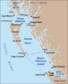
The North Coast of British Columbia is deeply incised by numerous fjords.

See also
