North Shore (Sydney) facts for kids
Quick facts for kids North ShoreSydney, New South Wales |
|||||||||||||||
|---|---|---|---|---|---|---|---|---|---|---|---|---|---|---|---|

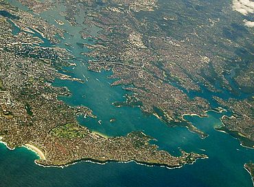
Sydney Harbour with the North Shore extending from its northern side (right) with Sydney CBD (left) and Eastern Suburbs (bottom) on its southern shore.
|
|||||||||||||||
| Time zone | AEST (UTC+10) | ||||||||||||||
| • Summer (DST) | AEDT (UTC+11) | ||||||||||||||
| LGA(s) |
|
||||||||||||||
| State electorate(s) |
|
||||||||||||||
| Federal Division(s) | |||||||||||||||
|
|||||||||||||||
The North Shore is a large area in Northern Sydney, New South Wales, Australia. It includes suburbs located on the northern side of Sydney Harbour. This area stretches north up to Wahroonga. It also covers suburbs found between Middle Harbour and the Lane Cove River.
The name "North Shore" is a common way to describe this part of Sydney. It is not an official government boundary. People often decide for themselves what areas it includes.
Contents
History of the North Shore
The land now known as the North Shore was once home to several groups of Eora people. One important group was the Cammeraygal people. Their traditional lands were in what is now the Lower North Shore. This includes areas like North Sydney, Willoughby, and Mosman.
The Cammeraygal people lived here for about 5,800 years. They stayed in the area until the 1820s. The suburb of Cammeray is named after them. Other clans lived nearby, like the Boregegal at Bradleys Head.
After the British arrived in Sydney in 1788, few people settled on the North Shore. The land was rougher than the southern side of the harbour. It was not very good for farming. Early activities included cutting down trees and building boats. Some small fruit farms existed where the soil was good.
Things started to change when the North Shore railway line was built in the 1890s. But getting to the Sydney CBD was still hard. The CBD is on the southern side of the harbour. This changed when the Sydney Harbour Bridge was finished in 1932. After the bridge opened, many new suburbs grew on the North Shore.
Geography and Natural Features

The "North Shore" is a general term for a region in Northern Sydney. Its exact borders are not fixed. Generally, it covers the land north of Sydney Harbour. The Lane Cove River and National Park are to its west. The M1 motorway to Newcastle is to its northwest. Middle Harbour is to its southeast. Ku-ring-gai Chase National Park is to its northeast.
Local government areas within the North Shore include City of Willoughby and Municipality of Lane Cove. Also, North Sydney Council, Municipality of Mosman, and Ku-ring-gai Council are part of it. Some suburbs of City of Ryde and Hornsby Shire are also included.
Most of the North Shore is part of the Hornsby Plateau. This is a large sandstone plateau. It has many hills and valleys. The plateau starts north of Port Jackson and goes up to the Hawkesbury River. This means the North Shore is quite hilly. Many steep valleys lead down to the harbour and rivers.
You can find many parks and bushland areas here. Lane Cove National Park, Garigal National Park, and Sydney Harbour National Park have lots of native bush. These parks are along the Lane Cove River, Middle Harbour, and Sydney Harbour. You can go bushwalking and abseiling in places like Lindfield. Gordon has one of Sydney's biggest bat colonies. It lives in a special bat reserve near Middle Harbour.
Upper North Shore

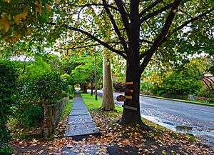
The "Upper North Shore" usually includes all suburbs in the Ku-ring-gai Council area. It also covers a small part of Hornsby Shire. This area is between Lane Cove National Park and Ku-ring-gai National Park. It is northwest of the Sydney CBD.
According to the 2016 Australian census, the Ku-ring-gai Council area is one of the wealthiest in Australia. In 2015, the government suggested combining Ku-ring-gai Council with Hornsby Council. But this plan was stopped in 2017 after people protested.
Lower North Shore

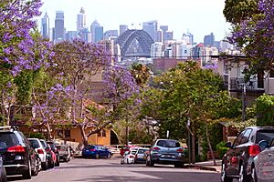
The "Lower North Shore" is the land north of the Sydney Harbour Bridge. It is located between the Lane Cove River and Middle Harbour. It goes as far north as Boundary Street in Roseville. This area includes suburbs in Mosman Council, City of Willoughby, Municipality of Lane Cove, North Sydney Council, and Municipality of Hunter's Hill. Some suburbs of City of Ryde are also part of it.
In 2016, the government also suggested combining some Lower North Shore councils. These included Mosman, Willoughby, and North Sydney councils. But this plan was also stopped in 2017.
Suburbs right next to Sydney Harbour in the Lower North Shore include Mosman, Cremorne Point, Neutral Bay, and Kirribilli. Also, Milsons Point, Lavender Bay, McMahons Point, and Waverton are here.
Getting Around the North Shore
The main roads on the North Shore are Military Road and the Pacific Highway. The Warringah Expressway is also important. Other major roads include parts of Pennant Hills Road and Epping Road.
The North Shore railway line connects many areas. It provides train services between the Sydney central business district, North Sydney, and Hornsby. The Sydney Metro Northwest also serves suburbs like Chatswood, North Ryde, and Macquarie Park. This metro line connects North West Sydney with South West Sydney.
Many bus routes serve the area, especially the Lower North Shore. Ferries also connect many harbour suburbs to Circular Quay in the city centre.
Shopping and Business Areas
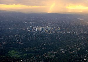
The North Shore has many important shopping and business centres. These include North Sydney, Crows Nest, Chatswood, and St Leonards. St Ives and Hornsby are also major centres.
North Sydney and Chatswood are the largest business areas. Many international companies have their Australian offices here. Chatswood is one of Sydney's biggest shopping areas. It has large shopping centres like Westfield Chatswood and Chatswood Chase. Macquarie Park is home to Macquarie Centre, another large shopping centre. Macquarie Park also has many apartments and offices.
Fun Things to Do and See
The Lower North Shore has many famous landmarks. These include the Sydney Harbour Bridge and Taronga Zoo in Mosman. Admiralty House is the Sydney home of the Governor-General of Australia. Kirribilli House is the Sydney home of the Prime Minister of Australia. You can also visit Luna Park and Balmoral Beach.
Other local landmarks include the Lane Cove Azalea Beds. There is also Blues Point Tower and Eden Gardens. The Stanton Library is in North Sydney. The Hornsby Water Clock is another interesting spot.
The region has hundreds of parks and nature reserves. These include Sydney Harbour National Park and the Lane Cove National Park. Major sports grounds include North Sydney Oval, which is the biggest in the area.
Events and Celebrations
The North Shore hosts many festivals and events each year. These include Tartan Day in Lane Cove. The Guringgai Festival celebrates northern Sydney's Aboriginal people. The Moocooboola Festival is held in Hunters Hill. Mosman and Lane Cove also have their own festivals. Chatswood celebrates Chinese New Year.
Mosman, North Sydney, and Willoughby also hold an annual art prize. All local areas celebrate Australia Day on January 26.
The Willoughby Spring Festival happens every September. It lasts for a month and has over 40 events. These include live music, exhibitions, and cultural celebrations. The main event is the Willoughby Street Fair. During this fair, the Chatswood CBD fills with market stalls, performers, and dancers.
Local Media
The local newspapers for the North Shore include the Sydney Observer. There is also the Hornsby and Upper North Shore Advocate. Other papers are The North Shore Times and The Mosman Daily. The Northern District Times and Northside magazine also cover the area.
Climate
The North Shore has a humid subtropical climate. This is like the rest of the Sydney area. Turramurra gets a lot of rain, about 1400 mm per year. The inland parts of the North Shore are a bit cooler in winter. This is especially true for the Upper North Shore.
Suburbs of the North Shore
This list is not complete. The North Shore does not have official government borders.
Upper North Shore
- East Killara
- East Lindfield
- Gordon
- Hornsby
- Killara
- Lindfield
- North Turramurra
- North Wahroonga
- Pymble
- Roseville
- Roseville Chase
- St Ives
- St Ives Chase
- South Turramurra
- Turramurra
- Wahroonga
- Waitara
- Warrawee
- West Pymble
Lower North Shore
- Artarmon
- Cammeray
- Castle Cove
- Castlecrag
- Chatswood
- Chatswood West
- Cremorne
- Cremorne Point
- Crows Nest
- Greenwich
- Hunters Hill
- Kirribilli
- Lane Cove
- Lane Cove North
- Lane Cove West
- Lavender Bay
- Longueville
- McMahons Point
- Middle Cove
- Milsons Point
- Mosman
- Naremburn
- Neutral Bay
- North Ryde
- North Sydney
- North Willoughby
- Northbridge
- Northwood
- Riverview
- St Leonards
- Waverton
- Willoughby
- Willoughby East
- Woolwich
- Wollstonecraft
 | Delilah Pierce |
 | Gordon Parks |
 | Augusta Savage |
 | Charles Ethan Porter |


