
Ventura County, California facts for kids
Quick facts for kids
Ventura County
|
|||
|---|---|---|---|
| County of Ventura | |||
 .jpg)    Images, from top down, left to right: Ventura City Hall in Old Town Ventura, Ojai Arcade in Ojai, a view of Camarillo, Ronald Reagan Presidential Library in Simi Valley, Point Mugu
|
|||
|
|||

Location in the state of California
|
|||
| Country | United States | ||
| State | California | ||
| Region | Greater Los Angeles California Central Coast |
||
| Created | March 22, 1872 | ||
| Established | January 1, 1873 | ||
| Named for | Mission San Buenaventura, which was named after Saint Bonaventure | ||
| County seat | Ventura | ||
| Largest city | Oxnard (population) Thousand Oaks (area) |
||
| Government | |||
| • Type | Council–CEO | ||
| • Body | Board of Supervisors | ||
| Area | |||
| • Total | 2,208 sq mi (5,720 km2) | ||
| • Land | 1,843 sq mi (4,770 km2) | ||
| • Water | 365 sq mi (950 km2) | ||
| Highest elevation | 8,835 ft (2,693 m) | ||
| Population | |||
| • Total | 843,843 | ||
| • Density | 458/sq mi (177/km2) | ||
| GDP | |||
| • Total | .329 billion (2022) | ||
| Time zone | UTC−8 (Pacific Time Zone) | ||
| • Summer (DST) | UTC−7 (Pacific Daylight Time) | ||
| Area codes | 805/820, 818/747 | ||
| FIPS code | 06-111 | ||
| GNIS feature ID | 277320 | ||
| Congressional districts | 24th, 26th, 32nd | ||


Ventura County is a county in the southern part of California. In 2020, about 843,843 people lived there. The biggest city is Oxnard, and the county seat (the main government city) is Ventura.
Ventura County is part of the larger Greater Los Angeles area. It is also the most southern county along the California Central Coast. Two of the Channel Islands are part of the county: Anacapa Island and San Nicolas Island. Anacapa Island is the most visited island in Channel Islands National Park.
Contents
History of Ventura County
Early People: The Chumash

Ventura County was first home to the Chumash people. They lived here for 10,000 to 12,000 years. The Chumash were skilled hunter-gatherers, fishermen, and traders. They traded with other Native American groups.
The Chumash were known for their amazing rock paintings and beautiful baskets. You can see reconstructed Chumash houses at the Chumash Indian Museum in Thousand Oaks. There are also ancient rock paintings, like those at the Burro Flats Painted Cave in Simi Valley.
A special part of their life was the plank canoe, called a tomol. These canoes helped them trade with Chumash people on the Channel Islands. Some words, like tomolo'o (canoe), might even be linked to Polynesian languages. The Chumash language spoken in Ventura County was called Ventureño.
Many places in the county have Chumash names. For example, Ojai means "moon," and Simi Valley comes from "Shimiyi," meaning "stringy clouds." Other names include Point Mugu ("beach"), Saticoy ("sheltered for the wind"), and Sespe Creek ("kneecap").
Spanish Exploration and Missions

In 1542, explorers led by Juan Rodríguez Cabrillo were the first Europeans to reach this area. They anchored near Point Mugu.
Spain started to settle California in 1769. Gaspar de Portolà led an army expedition through Ventura County in August 1769. A priest with him, Father Juan Crespí, wrote that the area was perfect for a mission. Father Junípero Serra later founded a mission here.
On March 31, 1782, Father Serra founded the Mission San Buenaventura. It was named after Saint Bonaventure. The town that grew around the mission was first called San Buenaventura. Since 1891, it has been known as Ventura.
In the 1790s, the Spanish Governor gave large pieces of land, called ranchos, to soldiers. These ranches were used for raising animals. In Ventura County, Rancho Simi was given out in 1795, and Rancho El Conejo in 1802.
Mexican Rule and Changes
In 1822, California became part of Mexico, which had won its independence from Spain. The land that belonged to the King of Spain now belonged to Mexico.
By the 1830s, Mission San Buenaventura was not as strong as it used to be. The Mexican government took control of the missions in 1834. They started giving land rights to Mexican Californians, often to soldiers who had retired. By 1846, there were 19 rancho grants in Ventura County.
The Native Americans who worked at the mission gradually left to work on the ranchos. By 1839, only 300 Native Americans were left at the Mission, and it started to fall apart.
Becoming Part of the United States
The Mexican–American War began in 1846. In January 1847, Captain John C. Frémont led his troops into San Buenaventura. The Europeans had left, leaving only Native Americans at the Mission. The Treaty of Guadalupe Hidalgo officially made California part of the United States in 1848.
In 1849, California became a territory and was divided into 27 counties. At first, Ventura County was the southern part of Santa Barbara County.
The 1860s brought many changes. A drought made it hard for the ranchos, and most were sold off. Large areas of land were bought by people who thought there was oil. A U.S. Post Office opened at Mission San Buenaventura in 1861. On April 1, 1866, San Buenaventura became the first official town in what would be Ventura County.
On January 1, 1873, Ventura County officially separated from Santa Barbara County. A courthouse and a pier were built in San Buenaventura that same year. A bank opened, and the first public library was created. The school system grew, with the first high school opening in 1890.
Other towns also started to grow. Hueneme was planned in 1874, and Santa Paula in 1875. Towns like Bardsdale, Fillmore, Piru, and Montalvo were established in 1887. By 1892, Simi, Somis, Saticoy, and Moorpark were founded. Oxnard was one of the last, started in 1898.
The Southern Pacific Railroad built tracks through San Buenaventura in 1887. For easier printing, they shortened San Buenaventura to Ventura on their train schedules. The Post Office soon did the same. While the city's official name is still San Buenaventura, most people call it Ventura.

Oil has been known in Ventura County for a long time. The Chumash people used natural tar for waterproofing. In the 1860s, people tried to get oil, but it wasn't very successful. In 1913, serious oil exploration began. The "Lloyd No. 1" well started in 1914. It hit oil but was destroyed. More wells followed, and in 1916, the large South Mountain Oil Field was found. At its peak, the Ventura Avenue oilfield produced 90,000 barrels of oil a day.
In 1928, the St. Francis Dam collapsed. This sent a huge amount of water rushing through the Santa Clarita Valley. It caused a lot of damage and was the biggest disaster in Ventura County's history.
Modern Ventura County


Ventura County is often split into two main parts: East County and West County. The Conejo Grade divides them. East County includes cities like Thousand Oaks, Moorpark, and Simi Valley. West County has cities like Camarillo, Oxnard, and Ventura. West County has some of the oldest cities and the largest beach communities.
In the mid-1900s, many people moved to East County from the San Fernando Valley in Los Angeles. This caused a big population growth in areas like the Conejo and Simi Valleys. Making U.S. Route 101 a full freeway in the 1960s made it easier to travel to Los Angeles. This helped new towns grow.
Today, most cities in Ventura County are almost fully developed. There is still open space, but it's often in greenbelts between cities. Because of its quiet feel and closeness to Los Angeles, the Conejo Valley has become a popular place to live.
The Thomas Fire
The Thomas Fire was a huge wildfire in Ventura and Santa Barbara Counties in December 2017. It burned over 281,000 acres. It became the largest wildfire in modern California history. The fire destroyed more than 1,000 buildings and caused over $2.1 billion in damages. The farming industry lost at least $171 million.
Geography of Ventura County

Ventura County covers about 2,208 square miles. Most of this is land, but 365 square miles (16.5%) is water.
A large part of the county is on the Oxnard Plain. This flat area includes cities like Oxnard and Camarillo. Other cities are in valleys between mountains, such as the Santa Clara River Valley, Conejo Valley, and Simi Valley. Most people in Ventura County live in the southern part.
Because there isn't much rain, saving water is very important. The weather is usually mild and dry, but it changes depending on the mountains and valleys. The Santa Clara River is the main waterway. Lake Casitas, a man-made lake, is the biggest body of water.
The highest mountains in the county are Mount Pinos (8,831 feet), Frazier Mountain (8,017 feet), and Reyes Peak (7,525 feet). These mountains have coniferous forests and get a lot of snow in winter. Mount Pinos is a sacred place for the Chumash Indians. They call it Iwihinmu and believe it is the center of the universe.
The USDA Economic Research Service once said Ventura County was the most desirable county to live in the 48 states. They looked at things like mild, sunny winters, warm summers, and access to water.
Natural Landscapes


More than half of Ventura County (53%) is covered by national forests. The land outside the forests is mostly farms (59%) and urban areas (17.5%). North of Highway 126, the county is very mountainous and wild. Most of this land is in the Los Padres National Forest. This includes the Chumash Wilderness and the large Sespe Wilderness.
The flat coastal area was formed by dirt and sand from the Santa Clara River. This area is known as the Oxnard Plain. Most of the good farming land in the county is here. Small coastal mountains surround Ventura County on the land side. These include the Santa Ynez Mountains and Santa Monica Mountains.

The Santa Clara River valley is the most important valley. It flows from Los Angeles to the Pacific Ocean. Its main smaller rivers are Piru Creek and Sespe Creek. The Ventura River valley is a narrow valley north of Ventura. The Ojai Valley is a rich farming area surrounded by mountains.


The county has a diverse coastline that is about 43 miles long. There are many State beaches like Emma Wood and San Buenaventura. Other popular beaches include Channel Islands Beach and Silver Strand Beach. Point Mugu State Park has steep coastal cliffs. Rincon Point is a famous surf spot.
The Channel Islands in Ventura County are Anacapa and San Nicholas Islands.
Weather and Climate

Ventura County has different climates because of its varied landscape. Summers are dry, so farms need irrigation. Near the ocean, the average yearly temperature is around 60°F. In the northern mountains, it can be colder, below 45°F.
The hottest month is July, with average high temperatures between 70°F and 80°F near the coast. In the valleys, it can get over 90°F. In January, the average low temperature is around 40°F on the coast, but colder in the northern parts.
Rainfall is usually between 10 and 15 inches a year. In the Topatopa Mountains, it can be over 33 inches. The driest areas get less than 5 inches. Snowfall is common in the northern mountains, with Mount Pinos getting over 20 inches a year.
Air Quality
Most of the air pollution in Ventura County comes from cars. Other sources include factories, gas stations, and cleaning products.
Neighboring Counties
- Santa Barbara County, California — west
- Kern County, California — north
- Los Angeles County, California — east
Protected Natural Areas
- Angeles National Forest (part)
- Channel Islands National Park (part)
- Hopper Mountain National Wildlife Refuge
- Los Padres National Forest (part)
- Santa Monica Mountains National Recreation Area (part)
- Dick Smith Wilderness (part)
Rivers and Creeks


Here are some of the rivers and creeks in Ventura County:
People and Population
Ventura County has grown a lot over the years. In 1880, there were just over 5,000 people. By 2020, the population was 843,843.
Who Lives Here?
In 2020, the population of Ventura County was 843,843.
- About 42.76% of people were White (not Hispanic).
- About 1.62% were Black or African American (not Hispanic).
- About 7.50% were Asian (not Hispanic).
- About 43.29% of people were Hispanic or Latino (of any race).
The county is a mix of many different cultures and backgrounds.
Housing in Ventura County
Housing in Ventura County is often expensive because there aren't many homes available. It's usually one of the most expensive counties in Southern California. Groups are working to build more affordable homes for veterans and low-income families. There are also waiting lists for farmworker housing.
Economy
In 2019, the county's economy faced challenges because housing was expensive and there weren't enough new jobs.
Farming and Crops
Farming is a big part of Ventura County's economy. Lemons are the second most valuable crop, bringing in over $244 million a year. Valencia oranges and mandarins are also important crops.
Hemp farming has also become legal for agricultural uses. By October 2019, about 4,100 acres were registered for growing hemp. However, some cities and areas have banned or paused hemp farming due to complaints about the smell.
Technology and Business
Amgen, a biotechnology company based in Thousand Oaks, is the largest publicly traded company in Ventura County. The Trade Desk, a company in Ventura that works with advertising on streaming services, is the second largest.
Arts and Culture
Ventura County has many places to learn about history and art:
- Albinger Archaeological Museum: Located in Ventura, this museum shows the history of five different cultures over 3,500 years.
- Channel Islands Maritime Museum: In Oxnard, this museum teaches about the ocean, ships, and sea art.
- The Chumash Indian Museum: In Thousand Oaks, this museum helps people learn about the Chumash people, their history, and culture.
- Museum of Ventura County: In Ventura, this museum focuses on the history and art of the Ventura County area.
- Santa Paula Art Museum: This museum in Santa Paula has two historic buildings. It shows art and offers classes.
Sports
The city of Ventura has a soccer team called Ventura County Fusion. They play in the USL Premier Development League. In 2024, the Ventura County Football Club (formerly Galaxy 2) became the first MLS affiliate team in Ventura County. They play their home games at Cal Lutheran University in Thousand Oaks.
Education
Schools for Kids (K-12)
Ventura County has many school districts. Some are unified districts, meaning they include all grades from kindergarten to 12th grade. Others are just for high schools or elementary schools.
Unified School Districts:
- Conejo Valley Unified School District
- Fillmore Unified School District
- Moorpark Unified School District
- Oak Park Unified School District
- Ojai Unified School District
- Santa Paula Unified School District
- Simi Valley Unified School District
- Ventura Unified School District
High School District:
- Oxnard Union High School District
Elementary School Districts:
- Briggs Elementary School District
- Hueneme Elementary School District
- Ocean View Elementary School District
- Oxnard Elementary School District
- Pleasant Valley Elementary School District
- Rio Elementary School District
- Somis Union Elementary School District
Libraries for Everyone
Public Libraries
The Ventura County Library has 12 locations across the county. Some cities also have their own libraries that are separate from the county system. These include Camarillo, Moorpark, Oxnard, Santa Paula, Simi Valley, and Thousand Oaks.
College Libraries
Colleges and universities in Ventura County have libraries for their students and teachers. These include:
- Edward Laurence Doheny Memorial Library at St. John's Seminary
- Evelyn and Howard Boroughs Library at Ventura College
- John Spoor Broome Library at California State University Channel Islands
- Moorpark College Library
- Oxnard College Library
- Pearson Library at California Lutheran University
- St. Bernardine of Siena Library at Thomas Aquinas College
Other Libraries
The Ronald Reagan Presidential Library is located in Simi Valley. It holds many important documents and items from President Reagan's time.
The Ventura County Law Library helps judges, lawyers, and others find legal information.
Transportation
Main Roads


Major highways that run through Ventura County include:
 U.S. Route 101
 State Route 1
 State Route 23
 State Route 33
 State Route 118
 State Route 126
Public Transport
Ventura County has train services like Amtrak and Metrolink. There are also bus services like Greyhound Lines, Gold Coast Transit, and VISTA. Some cities like Camarillo and Simi Valley have their own smaller bus systems.
Boats can take you to the five islands of Channel Islands National Park.
Airports
- Oxnard Airport: This is the county's largest airport. It used to have public flights but now only handles private planes.
- Camarillo Airport: This airport used to be a U.S. Air Force base. Now it's for general aviation (private planes). It's also home to the Ventura County Sheriff's Department Aviation Unit and the Fire Department.
- Santa Paula Airport: This is a privately owned airport that is open to the public for general aviation.
Cities and Towns
Cities
- Camarillo
- Fillmore
- Moorpark
- Ojai
- Oxnard
- Port Hueneme
- Santa Paula
- Simi Valley
- Thousand Oaks
- Ventura (county seat)
Unincorporated Communities
These are smaller communities that are not officially cities.
Population Ranking of Communities (2020 Census)
† county seat
| Rank | City/Town/etc. | Type | Population (2020 Census) |
|---|---|---|---|
| 1 | Oxnard | City | 202,736 |
| 2 | Thousand Oaks | City | 126,966 |
| 3 | Simi Valley | City | 126,356 |
| 4 | † Ventura (San Buenaventura) | City | 110,763 |
| 5 | Camarillo | City | 70,741 |
| 6 | Moorpark | City | 36,284 |
| 7 | Santa Paula | City | 30,657 |
| 8 | Port Hueneme | City | 21,954 |
| 9 | Fillmore | City | 16,419 |
| 10 | Oak Park | CDP | 13,898 |
| 11 | Ojai | City | 7,637 |
| 12 | El Rio | CDP | 7,037 |
| 13 | Mira Monte | CDP | 6,618 |
| 14 | Oak View | CDP | 6,215 |
| 15 | Meiners Oaks | CDP | 3,911 |
| 16 | Santa Rosa Valley | CDP | 3,312 |
| 17 | Casa Conejo | CDP | 3,267 |
| 18 | Channel Islands Beach | CDP | 2,870 |
| 19 | Piru | CDP | 2,587 |
| 20 | Bell Canyon | CDP | 1,946 |
| 21 | Lake Sherwood | CDP | 1,759 |
| 22 | Somis | CDP | 1,429 |
| 23 | Santa Susana | CDP | 1,160 |
| 24 | Saticoy | CDP | 1,133, |
Images for kids
-
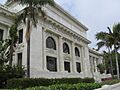
Ventura City Hall
-
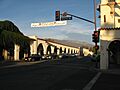
Ojai Arcade in Ojai
-
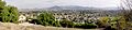
A view of Camarillo
-
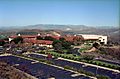
Ronald Reagan Presidential Library in Simi Valley
-
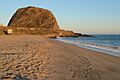
Point Mugu
-
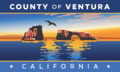
Flag of Ventura County
-
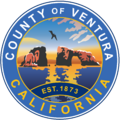
Seal of Ventura County
-
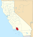
Location in the state of California
See also
 In Spanish: Condado de Ventura para niños
