
County Carlow facts for kids
Quick facts for kids
County Carlow
Contae Cheatharlach
|
||
|---|---|---|
|
||
| Nickname(s):
The Dolmen County
|
||
| Anthem: "Follow Me up to Carlow" | ||
 |
||
| Country | Ireland | |
| Province | Leinster | |
| Established | 1210 | |
| County town | Carlow | |
| Government | ||
| • Type | County Council | |
| Area | ||
| • Total | 897 km2 (346 sq mi) | |
| Area rank | 31st | |
| Highest elevation | 794 m (2,605 ft) | |
| Population
(2016)
|
||
| • Total | 56,932 | |
| • Rank | 30th | |
| • Density | 63.47/km2 (164.38/sq mi) | |
| Demonym(s) | Carlovian | |
| Time zone | UTC±0 (WET) | |
| • Summer (DST) | UTC+1 (IST) | |
| Eircode routing keys |
R21, R93 (primarily)
|
|
| Telephone area codes | 059 (primarily) | |
| Vehicle index mark code |
CW | |

County Carlow ( KAR-loh; Irish: Contae Cheatharlach) is a county located in the South-East Region of Ireland, within the province of Leinster. Carlow is the second smallest and the third least populous of Ireland's 32 traditional counties. Carlow County Council is the governing local authority.
The county is named after the town of Carlow, which lies on the River Barrow and is both the county town and largest settlement, with over 40% of the county's population. Much of the remainder of the population also reside within the Barrow valley, in towns such as Leighlinbridge, Muine Bheag, Tinnahinch, Borris and St Mullins. Carlow shares a border with Kildare and Laois to the north, Kilkenny to the west, Wicklow to the east and Wexford to the southeast.
Carlow is known as "The Dolmen County", a nickname based on the Brownshill Dolmen, a 6,000-year-old megalithic portal tomb which is reputed to have the heaviest capstone in Europe, weighing over 100 metric tonnes. The town of Carlow was founded by the Normans in 1207 and the county was shired shortly thereafter, making it one of the oldest counties in Ireland. During the 14th century, the county was the seat of power of the Kingdom of Leinster, as well as the capital of the Lordship of Ireland from 1361 to 1374.
Contents
Geography and political subdivisions
Carlow, or "Ceatharlach" originally part of the Norman Palantine-county of Leinster, became a separate county probably around 1306. At that time it was larger than today, extending to and including the coastal area around Arklow, though control of this area became disputed with the Irish chieftains of the area. These areas were given over to County Wicklow in 1606-07
Baronies
There are seven historic baronies in the county: Carlow, Forth, Idrone East, Idrone West, Rathvilly, St Mullin's Lower and St Mullin's Upper.
Towns and villages
People
- Pierce Butler - soldier, planter, and statesman, recognized as one of United States' Founding Fathers. He represented South Carolina in the Continental Congress and the United States Senate.
- Myles Keogh - American Civil War military officer and later Captain of Company I, U.S. 7th Cavalry Regiment - Fought in Indian Wars and was killed at the Battle of the Little Bighorn in 1876. He was born in Orchard, Leighlinbridge in 1840.
- William Dargan - engineer, often seen as the father of Irish railways.
- Richie Kavanagh - comic songwriter, from Raheenwood, Fenagh, Co. Carlow.
- John Tyndall - the 19th century scientist who was the first to explain why the sky is blue.
- Derek Ryan - Country music singer & former member of Pop band D-side
- Saoirse Ronan - Oscar and Golden Globe nominated actress.
- Kathryn Thomas - RTÉ presenter.
- Samuel Haughton - polymath, in 1866 published a formula for calculating the drop needed to cause instantaneous death at hangings.
- Peter Murphy - radio and television broadcaster, presented RTÉ's Cross Country Quiz, was born in Carlow
- Sean O'Brien Leinster and Ireland international rugby player.
- Frank O'Meara, Carlow-born Irish artist known for his Impressionist, plein air landscape painting (1853-1888).
- James Fenelon - member of the Wisconsin State Assembly.
- David Mullins - Irish jockey, notable for riding Rule The World to win the 2016 Grand National
- Mary O'Toole - first woman municipal judge in the United States
Economy
The Central Statistics Office estimate of Carlow's total household income in 2017 was €1.48 billion, ranking 24th out of 26 counties However, Carlow residents were the 13th highest per capita tax contributors in the State, returning a total of €331 million in taxes in 2017. This was primarily driven by the higher aggregate value of economic output from the county, along with higher wages when compared to counties in other regions such as the Midland or Border Region. Per capita disposable income in 2017 was €20,154, or 96.63% of the State average, ranking it 8th in the country. The primary economic sectors within the county are retail, services, manufacturing, pharmaceuticals and the food and drink industry.
Agriculture


Despite its small size, Carlow has a large agricultural sector, and is a major producer of dairy, cereals and vegetables. Carlow has a tradition of producing high-quality agricultural products. Samuel Lewis's 1837 Topographical Dictionary of Ireland noted the "highly improved state" of the county's agricultural practices. It further states that "wheat of a superior quality is grown in every part" and that barley grown in Carlow "has long been celebrated and in great demand, and large quantities are annually shipped to England".
Dairying is the most profitable agricultural sector in the county, which historically has always been the case. Lewis's 1837 description states "Dairies are numerous and the dairy farms extensive and profitable; butter, generally of very superior quality and much esteemed in English and foreign markets, is the chief produce". As of 2018, there were 102,357 cows within the county, approximately 60% of which were beef cattle, and the remainder dairy cattle. The county also has Ireland's 13th largest sheep herd (108,851 sheep) and 13th largest pig herd (40,715 pigs).
There are 1,806 individual farms in the county, with a total farmed area of 71,142 ha (175,796 acres), accounting for 79% of land area. Of this, 16,875 ha (41,699 acres) is under tillage, the 9th highest in Ireland, and 3,450 ha (8,525 acres) of land is dedicated to horticulture and fruit, the 8th highest. The average size of a farm in the county is 39.4 ha (97 acres), significantly above the national average of 31 ha (77 acres) and according to the Irish Farmers' Association, the total value of agricultural produce from Carlow in 2016 was €188 million.
Industry

Historically, Carlow was the primary producer of sugar beet in Ireland. The Irish Sugar Manufacturing Company was created in 1926 by Carlow businessman Edward Duggan, and was a landmark moment in the industrialisation of the nascent Irish State. In 1933 the plant was nationalised by the newly elected Fianna Fáil government. The government were pursuing a policy of autarky and recognised sugar manufacturing as a core national industry, creating a State-owned sugar company – Comhlucht Siúicre Éireann – with the Carlow plant as its headquarters. The plant's forced closure in 2005 due to the introduction of EU sugar quotas was highly controversial.
Manufacturing, biosciences, retail, services and agribusiness are the county's primary economic sectors. Burnside Group are the largest single employer in the county, with over 800 employees at their sites in Tullow, Muine Bheag and Carlow. Manufacturing firm Autolaunch employ 300 people at their plant in Muine Bheag. Pharmaceutical giant Merck Sharp & Dohme has a vaccine manufacturing plant in Carlow, which employs 300 people, and Glanbia agribusiness has two feed mills in the county, at Carlow and Tinnahinch. The county is also a key supplier to the Glanbia milk pool.
In the services and IT sector, US-based insurance firm Unum employs 150 people in Carlow town, and indigenous security firm Netwatch, headquartered in Carlow town, employs 160 people, with an additional 340 employees in the UK and USA.
Multinational oil and gas exploration company Tullow Oil was founded in Tullow by Aidan Heavey in 1985. The company, which is now headquartered in London, is listed on the Irish Stock Exchange and recorded a revenue of just under €1.6 billion in 2019.
Demographics
| Main immigrant groups, 2016 | |
| Nationality | Population |
|---|---|
| 2,591 | |
| 2,119 | |
| 448 | |
| 304 | |
| 231 | |
| 158 | |
| 155 | |
| 144 | |
| 125 | |
| *Includes Hong Kong SAR | |
| Historical population | ||
|---|---|---|
| Year | Pop. | ±% |
| 1653 | 4,969 | — |
| 1659 | 5,434 | +9.4% |
| 1821 | 78,952 | +1352.9% |
| 1831 | 81,988 | +3.8% |
| 1841 | 86,228 | +5.2% |
| 1851 | 68,078 | −21.0% |
| 1861 | 57,137 | −16.1% |
| 1871 | 51,650 | −9.6% |
| 1881 | 46,568 | −9.8% |
| 1891 | 40,936 | −12.1% |
| 1901 | 37,748 | −7.8% |
| 1911 | 36,252 | −4.0% |
| 1926 | 34,476 | −4.9% |
| 1936 | 34,452 | −0.1% |
| 1946 | 34,081 | −1.1% |
| 1951 | 34,162 | +0.2% |
| 1956 | 33,888 | −0.8% |
| 1961 | 33,342 | −1.6% |
| 1966 | 33,593 | +0.8% |
| 1971 | 34,237 | +1.9% |
| 1979 | 38,668 | +12.9% |
| 1981 | 39,820 | +3.0% |
| 1986 | 40,988 | +2.9% |
| 1991 | 40,942 | −0.1% |
| 1996 | 41,616 | +1.6% |
| 2002 | 46,014 | +10.6% |
| 2006 | 50,349 | +9.4% |
| 2011 | 54,612 | +8.5% |
| 2016 | 56,932 | +4.2% |
According to the Central Statistics Office, Carlow had a population of 56,932 in 2016; an increase of 2,320 since the 2011 Census of Ireland. Population growth from 2011 to 2016 included a natural decrease of 650 people (−1.14%) since the last census, coupled with an increase of 2,970 people (5.2%) due to net migration into the county. Immigration from outside Ireland resulted in a net increase of 297 people, and migration from other counties produced a net increase of 2,673 people. As of 2016, 47.6 percent of Carlow's population was born within the county, and a further 11.5 percent were born in neighboring Kilkenny, the majority of which would most likely be Carlow natives who were born in St. Luke's General Hospital in Kilkenny City. Excluding Kilkenny, 26.6 percent of the county's population were born elsewhere in Ireland, and 14.3 percent were born abroad.
In 2016, the racial composition of the county was:
- 94.3% White (84.2% White Irish, 9.2% Other White Background, 0.9% Irish Traveller)
- 1.3% Asian
- 1.2% Others including mixed
- 1.0% Black
- 2.2% Not stated
The five largest foreign national groups in Carlow are: British (4.6 percent), Polish (3.8 percent), Latvian (0.8 percent), Romanian (0.54 percent) and Lithuanian (0.41 percent).
In 2016, 7.2 percent of the county's population was reported as younger than 5 years old, 21.6 percent were between 5 and 19, 58.2 percent were between 20 and 65, and 13.0 percent of the population was older than 65. A total of 1,681 people (3.0 percent) were over the age of 80. The population was evenly split between Females (50.08 percent) and Males (49.92 percent).
In 2018, there were 834 births within the county, and the average age of a first time mother was 29.7 years.
Religion
| Religion in Carlow – 2016 | ||||
|---|---|---|---|---|
| Religion | Percent | |||
| Roman Catholic | 82.5% | |||
| Other Christian | 6.9% | |||
| Muslim | 1.0% | |||
| Other Stated Religions | 0.8% | |||
| None or Not Stated | 8.8% | |||

Within Carlow, 91.3% of residents identify with a religion, while 6.9% identified as having no religion. Additionally, 1.9% of people did not state their religion. Christianity and its various denominations was by far the largest religious group in the county, constituting 89.4% of the population. Islam was the only major non-Christian religion, with 587 adherents (1.0%).
The largest denomination by number of adherents in 2016 was the Roman Catholic Church with 46,982; followed by the Church of Ireland, England, Anglican and Episcopalian with 2,282, and other minor Christian denominations including Presbyterian and Pentecostal with 1,073 adherents. Orthodox Christianity had 587 adherents, and, coincidentally, the exact same number of people identified as Muslim in 2016. Buddhism had 99 adherents and Hinduism had 59. There were 159 adherents of all other religions, and 1,072 people did not state their religion.
The Cathedral of the Assumption in Carlow is the seat of the Roman Catholic Diocese of Kildare and Leighlin. Denis Nulty is the current bishop of Kildare and Leighlin. The 12th-century St Laserian's Cathedral in Old Leighlin was formerly the main cathedral of the Church of Ireland Diocese of Leighlin, but is now one of six cathedrals in the Diocese of Cashel and Ossory. The early 19th-century Scot's Church in Carlow town is the county's largest Presbyterian church, and the Carlow Islamic Cultural Centre is also located in Carlow town.
Continuing the trend which has been observed throughout Ireland since the Census of 2006, a significant increase in the number of people who identified as having no religion was observed between 2011 and 2016. This demographic increased by 79.3% from 2,198 in 2011 to 3,941 in 2016. People with no religion now account for 6.9% of the county's population.
Urban areas
Carlow is the county town and by far the largest settlement, with over 40% of the county's population. It is the 13th largest urban area in the state and, excluding cities, the 8th largest town.
Under CSO classification, an "Urban Area" is a town with a population greater than 1,500. Despite having only three towns which qualify as urban areas, County Carlow is predominantly an urban county. According to the 2016 Census, 55.8 percent of the county lived in urban areas (i.e. the three largest towns), and the remaining 44.2 percent lived in rural areas. Nearly two-thirds (64.3 percent) of the county's population live in the ten largest settlements.
|
Largest cities or towns in Carlow (Census 2016)
Source: |
||
|---|---|---|
| Rank | Pop. | |
| 1 | Carlow | 24,272 |
| 2 | Tullow | 4,673 |
| 3 | Muine Bheag | 2,837 |
| 4 | Rathvilly | 944 |
| 5 | Leighlinbridge | 914 |
| 6 | Ballon | 712 |
| 7 | Borris | 652 |
| 8 | Hacketstown | 597 |
| 9 | Carrickduff | 554 |
| 10 | Ballinabranna | 466 |
Sport
GAA

In GAA, Carlow is recognised as a dual county, meaning that Gaelic football and Hurling are equally popular. The county competes in Division 1B of the National Hurling League and Division 3 of the National Football League. Historically, the county has seen little success at top level in either sport, its biggest achievement being a Leinster football provincial win in 1944. That year, Carlow progressed to the All-Ireland semi-final, in which they were beaten by Kerry.
At club level, the county has seen much more success. Football clubs compete annually in the Carlow Senior Football Championship. The competition was first played for two years in 1889 and 1890, after which financial constraints suspended activities until 1897. Ballon O'Gorman Mahons won the first, and what would be their only, championship title in 1889, beating the Tullow Stars and Stripes 1–01 to 0–00. The most successful club in the county is Éire Óg, with 28 Senior Football Championship titles. At provincial level, clubs from Carlow have won 6 Leinster Senior Club Football Championship titles, the 3rd most of any county. Of these, Éire Óg have won 5 and O'Hanrahans GFC have won 1, the most recent of which was in 2000. No team from Carlow has ever won the All-Ireland Senior Club Football Championship, although Éire Óg have been runners up on two occasions in 1993 and 1996.
The county's hurling tradition is more recent, dating back to the first Carlow Senior Hurling Championship in 1927. The first championship was won by Carlow town in a 2–03 to 1–04 victory over Bagnelstown. The most successful hurling club in the county is St. Mullin's, with 27 titles. In 2013 Mount Leinster Rangers became the first Carlow club to win a Leinster Senior Club Hurling title, and the club made in to the finals of the All-Ireland the following year, but were beaten by Portumna.
Other sports

In addition to Gaelic games, clubs for other organised sports were set up across the county in the latter half of the 19th century. Several Carlow landlords were involved in the formation of the Phoenix Cricket Club (Ireland's oldest cricket club) in 1830. Local aristocrat Horace Rochfort founded the Carlow Cricket Club the following year. The Bagnelstown Cricket Club was set up in 1843, making the derby between these two clubs the longest provincial cricket rivalry in Ireland. Towards the end of his life, Rochfort also established the Carlow Rugby Football Club (Ireland's second oldest rugby club) in 1873, as well as the Carlow (and later Ireland) Polo club.
In association football, Carlow was represented in the League of Ireland by F.C. Carlow, which competed in the A Championship until the club's disbandment in 2016. While the county currently lacks a prominent football club, local amateur clubs compete in the Carlow and District Football League. There are also over a dozen golf courses within the county, among them the Carlow Golf Club, Killerig castle, Borris Golf Club and the Mount Wolseley Spa and Golf Resort.
| Club | Sport | League |
|---|---|---|
| County Carlow Football Club | Rugby union | Leinster League |
| IT Carlow Basketball | Basketball | NBCC League |
| Carlow Cricket Club | Cricket | Leinster Cricket Union |
| Carlow Hockey Club | Field hockey | Leinster Hockey Association |
| St Laurence O'Toole AC | Athletics | National Championships |
| Carlow Lawn Tennis Club | Tennis, Badminton, Squash |
|
Infrastructure


Transport
Road
County Carlow is located along the main Dublin to Waterford motorway, the M9. The M9 bypasses Carlow town to the south and has aided the growth of other commuter towns located near junctions along the M9, such as Leighlinbridge and Ballinabranna. The N80 cross-cuts the county for 33 km (21 mi), running from Carlow town to the Wexford border at Bunclody. The N81 was built to replace the old local railway line and traverses the county for 22 km (14 mi) from Ballon, through Rathvilly and Tullow, up to the County Wicklow border and on to Dublin city.
Bus Éireann, as well as private coach operators, provide bus services to villages and towns across the county.
The county is served by the following national primary roads and secondary roads:
| Major roads in County Carlow | ||||
|---|---|---|---|---|
| Road Name | Description | Length | ||
| Dublin – Carlow – Kilkenny – Waterford | 119.01 km (73.95 mi) | |||
| Tullamore – Portlaoise – Carlow – Enniscorthy | 114.7 km (71.3 mi) | |||
| Tallaght – Blessington – Baltinglass – Rathvilly – Tullow | 76.8 km (47.7 mi) | |||
Rail

Rail coverage in Carlow is sparse, with only one active rail line currently serving the county. The Great Southern and Western Railway extended to Carlow town in August 1846. This line remains in use and serves both Carlow town and Muine Bheag along the main Dublin–Waterford railway line. The line is operated by Irish Rail and runs eight trains per day (Monday to Friday) from Carlow to Heuston Station. It is primarily used by commuters to Dublin city.
Historically, the railway network was more extensive. A rail line ran from Naas in County Kildare to Tullow and Rathvilly. This line opened in 1886 and was designed to pass through the scenic west Wicklow hills. The line closed for passenger traffic in 1947, and finally terminated all operations in 1959.
An additional line connecting Carlow to Wexford was constructed by the Bagenalstown and Wexford Railway Company. It opened its first station in December 1858 and operated two trains per day before going bankrupt in June 1864. Great Southern and Western Railway bought the line, and its successor CIÉ continued its services until 1 January 1963.
Air
For international flights, Dublin Airport is the closest international airport to Carlow. The airport is less than 2 hours by car from most towns and villages in the county. The airport can also be accessed via bus from some of the larger towns, or by linking the train from Carlow town or Muine Bheag to the Aircoach in Dublin city. Waterford Airport is the closest regional airport; however, it is currently non-operational.
The county has two airstrips which are used for light aircraft and recreational flying. The Hacketstown Airfield (ICAO Code: EIHN) is located on the Tinaheally Road approximately 1 km (0.62 mi) south of Hacketstown and has one 375m runway. The Killamaster Airstrip is located 12 km (7.5 mi) northwest of Carlow town.
Images for kids
-
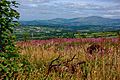
Undulating countryside of central Carlow
-
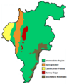
Physiographic regions of County Carlow
-
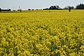
Flat plains typical of northern Carlow
-
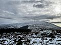
Summit of Mount Leinster
-
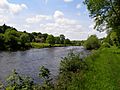
The River Barrow south of Borris
-
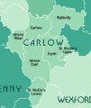
The Baronies of County Carlow
-
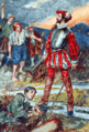
Art MacMurrough-Kavanagh, King of Leinster
-
Sir Edmund Butler led a revolt in 1569 after his lands were granted to an English settler
-
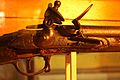
Brown Bess musket used in the 1798 Rebellion on display in the County Carlow Military Museum
-
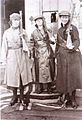
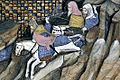
Cumann na mBan members standing on the Union Jack in Duckett's Grove, 1921
-
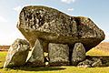
Brownshill Dolmen, c. 4,000 BC
-
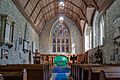
12th-century St Laserian's Cathedral
-
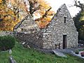
7th-century Monastic Site at St. Mullin's
-
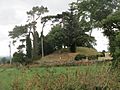
5th-century Motte in Rathvilly
-
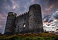
Carlow Castle, built in 1213, was the first Norman-style four towered keep in Britain or Ireland
-
Built in 1625, Huntington Castle is an early example of a plantation home
-
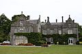
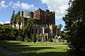
19th-century Lisnavagh House, a typical Anglo-Irish big house
-

Altamont Gardens
-
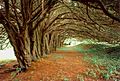
Yew grove at Clonegal, planted in the early 1600s
-

The Carlow Gaelic games flag
-
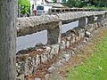
A "Carlow Fence"
-
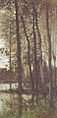
Autumnal greys (1880) by Frank O'Meara


.jpg)


See also
 In Spanish: Condado de Carlow para niños
