
Geography of Alaska facts for kids
Alaska is a huge state located in the northwestern part of North America. It's bordered by Canada to the east. Did you know Alaska is one of only two U.S. states not connected to other states? The other is Hawaii. Alaska has more ocean coastline than all the other U.S. states put together!
It's separated from Washington by about 500 miles (805 km) of Canadian land. This makes Alaska an "exclave" of the United States. It's part of the continental U.S. and the U.S. West Coast, but it's not directly connected to the main group of states.
Alaska shares borders with Yukon and British Columbia, Canada to the east. To the south, it meets the Gulf of Alaska and the Pacific Ocean. To the west, it's near Russia (specifically the Chukotka Autonomous Okrug), the Bering Sea, the Bering Strait, and the Chukchi Sea. The Beaufort Sea and the Arctic Ocean are to its north. Because Alaska stretches far west, even into the Eastern Hemisphere, it's technically both the westernmost and easternmost state in the United States! It's also the northernmost.
Alaska is the largest state in the United States by land area. It covers about 570,380 square miles (1,477,300 km²). That's more than twice the size of Texas, which is the next largest state! Alaska is home to 3.5 million lakes that are 20 acres (8.1 ha) or bigger. Huge areas of marshlands and wetlands with permafrost (permanently frozen ground) cover about 188,320 square miles (487,700 km²). Frozen water, like glacier ice, covers about 16,000 square miles (41,000 km²) of land. The Bering Glacier complex alone covers 2,250 square miles (5,800 km²).
Contents
Exploring Alaska's Diverse Regions
Alaska is a massive state with many different areas, each with its own unique features.
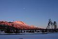
South Central Alaska: Where Most People Live
- South Central Alaska is the southern coastal area. Most of Alaska's people live here.
- Major cities like Anchorage, and growing towns like Palmer and Wasilla, are in this region.
- The economy here is strong, with jobs in petroleum (oil) industries, transportation, tourism, and two military bases.
Alaska Panhandle: Forests and Glaciers
- The Alaska Panhandle, also known as Southeast Alaska, is home to many of Alaska's bigger towns.
- This includes the state capital, Juneau.
- You'll find amazing tidewater glaciers and huge forests here.
- The economy relies on tourism, fishing, forestry, and state government jobs.
Southwest Alaska: Fishing and Wildlife
- Southwest Alaska is mostly coastal, touching both the Pacific Ocean and the Bering Sea.
- It doesn't have many people and isn't connected by roads.
- However, it's super important for the fishing industry! Half of all fish caught in the western U.S. come from the Bering Sea.
- Bristol Bay has the world's largest sockeye salmon fishery.
- This region includes Katmai and Lake Clark national parks.
- It's known for wet, stormy weather, wide-open tundra, and lots of salmon, brown bears, caribou, birds, and marine mammals.
Alaska Interior: Rivers and Extreme Temperatures
- The Alaska Interior is where Fairbanks is located.
- The land here has large, braided rivers like the Yukon River and the Kuskokwim River.
- You'll also find Arctic tundra lands and shorelines.
Alaskan Bush: Remote Villages and Wilderness
- The Alaskan Bush is the remote, less crowded part of the state.
- It includes 380 native villages and small towns like Nome, Bethel, Kotzebue, and Utqiaġvik.
- Utqiaġvik is the northernmost town in the United States!
The northeast corner of Alaska is covered by the Arctic National Wildlife Refuge. A large part of the northwest is covered by the National Petroleum Reserve–Alaska. This area is about 23 million acres (9.3 million ha). The Arctic is Alaska's most remote wilderness. One spot in the National Petroleum Reserve–Alaska is 120 miles (193 km) from any town or village. This makes it the most remote place from permanent homes in the United States.
With its many islands, Alaska has nearly 34,000 miles (55,000 km) of tidal shoreline. The chain of islands stretching west from the southern tip of the Alaska Peninsula is called the Aleutian Islands. Many active volcanoes are found in the Aleutians. For example, Unimak Island has Mount Shishaldin, an active volcano that rises to 9,980 feet (3,042 m) above sea level. This chain of volcanoes reaches all the way to Mount Spurr, west of Anchorage on the mainland.
One of North America's largest tides happens in Turnagain Arm, just south of Anchorage. The difference between high and low tide can be more than 35 feet (10.7 m)!
The Aleutian Islands cross the 180° longitude line. This means Alaska can be seen as the easternmost state as well as the westernmost. The International Date Line even bends west of 180° to keep all of Alaska, and therefore the entire continental United States, in the same legal day.
Understanding Alaska's Climate
Alaska has a wide range of climates, from mild coastal areas to very cold Arctic regions.
Southeast and South Central Alaska Climate
- The climate in south and southeastern Alaska is like an oceanic climate (Cfb and Cfc on the Köppen climate classification).
- This region is the wettest and warmest part of Alaska. It has milder winters and lots of rain all year.
- Juneau gets over 50 inches (127 cm) of rain a year, and Ketchikan gets over 150 inches (381 cm)!
- This is the only part of Alaska where the average daytime high temperature stays above freezing in winter.
- The climate of Anchorage and south central Alaska is mild for Alaska. This is because it's close to the ocean.
- While it gets less rain than southeast Alaska, it gets more snow. Days are often clearer.
- Anchorage gets about 16 inches (41 cm) of rain a year and around 75 inches (190 cm) of snow.
- It's a subarctic climate (Dfc) because its summers are short and cool.
Western Alaska Climate
- The climate of western Alaska is mostly shaped by the Bering Sea and the Gulf of Alaska.
- It's a subarctic oceanic climate in the southwest and a continental subarctic climate further north.
- Temperatures are somewhat moderate, even though the area is far north.
- This region has a huge variety in how much rain or snow it gets.
- An area from the northern side of the Seward Peninsula to the Kobuk River valley is technically a desert. Some parts get less than 10 inches (25 cm) of precipitation each year.
- On the other hand, some places between Dillingham and Bethel average around 100 inches (254 cm) of precipitation!
Interior Alaska Climate: Extremes of Hot and Cold
- The climate of the interior of Alaska is subarctic.
- Some of the highest and lowest temperatures in Alaska happen around Fairbanks.
- Summers can reach into the 90s °F (low-to-mid 30s °C).
- In winter, temperatures can drop below -60 °F (-51 °C)!
- Precipitation (rain or snow) is low in the Interior, often less than 10 inches (25 cm) a year. But any snow that falls in winter usually stays all winter.
The highest and lowest recorded temperatures in Alaska are both in the Interior. The highest was 100 °F (38 °C) in Fort Yukon on June 27, 1915. This makes Alaska tied with Hawaii for the state with the lowest high temperature in the U.S. The lowest official Alaska temperature was -80 °F (-62 °C) in Prospect Creek on January 23, 1971.
Extreme North Alaska Climate: Arctic Cold
- The climate in the far north of Alaska is Arctic (ET).
- It has long, very cold winters and short, cool summers.
- Even in July, the average low temperature in Utqiaġvik is 34 °F (1 °C).
- Precipitation is light here, with many places getting less than 10 inches (25 cm) per year. Most of this is snow, which stays on the ground almost all year.
Alaska's Average Temperatures
| Location | July (°F) | July (°C) | January (°F) | January (°C) |
|---|---|---|---|---|
| Anchorage | 65/51 | 18/10 | 22/11 | −5/−11 |
| Juneau | 64/50 | 17/11 | 32/23 | 0/−4 |
| Ketchikan | 64/51 | 17/11 | 38/28 | 3/−1 |
| Unalaska | 57/46 | 14/8 | 36/28 | 2/−2 |
| Fairbanks | 72/53 | 22/11 | 1/−17 | −17/−27 |
| Fort Yukon | 73/51 | 23/10 | −11/−27 | −23/−33 |
| Nome | 58/46 | 14/8 | 13/−2 | −10/−19 |
| Utqiaġvik | 47/34 | 08/1 | −7/−19 | −21/−28 |
How Alaska's Land is Managed
A large part of Alaska's land is owned and managed by the U.S. federal government. About 65% of Alaska is made up of national forests, national parks, and national wildlife refuges. The Bureau of Land Management takes care of about 87 million acres (35 million ha) of this land. The Arctic National Wildlife Refuge is managed by the United States Fish and Wildlife Service.
The State of Alaska owns about 24.5% of the land. Another 10% is managed by Native corporations. These were created under the Alaska Native Claims Settlement Act. Less than 1% of the land is owned by other private groups.
Alaska is divided into "boroughs," which are like counties in other states. Most of Alaska uses a two-level system: state and borough. Because Alaska doesn't have many people, most of the land is in the Unorganized Borough. This area doesn't have its own borough government; it's managed directly by the state. In 2000, 57.71% of Alaska's land was in the Unorganized Borough, but only 13.05% of the state's population lived there. For counting purposes, the United States Census Bureau divides this area into census areas.
Anchorage combined its city government with the Greater Anchorage Area Borough in 1971. This formed the Municipality of Anchorage. It includes the main city and nearby communities. Fairbanks, however, has a separate borough (the Fairbanks North Star Borough) and a separate city government.
Images for kids
-
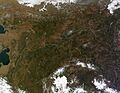
Central Alaska in late September, as seen from a satellite
-
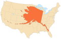
Alaska's area compared to the 48 contiguous states
-
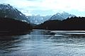
Near Little Port Walter in Southeast Alaska
-
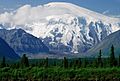
Mount Sanford in the Wrangell Mountains
-
Kenai River on the Kenai Peninsula
-
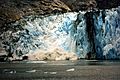
Calving glacier
-

Alaska has more acreage of public land owned by the federal government than any other state.
-
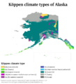
Köppen climate types of Alaska
-
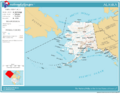
Map of Alaska
-
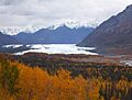
Matanuska glacier


