Hudson Bay drainage basin facts for kids
Quick facts for kids Hudson Bay drainage basin |
|
|---|---|

The Hudson Bay drainage connects primarily to the Labrador Sea just south of Davis Strait, as depicted on most atlases such as those of the National Geographic Society, just north of the 60th parallel north and northeast of the Labrador Peninsula
|
|
| Area | 3,861,400 km2 (1,490,900 sq mi) |
| Geology | |
| Type | Drainage basin |
| Geography | |
| Location | North America |
| Country | |
The Hudson Bay drainage basin is a huge area in northern North America. It's where all the surface water (like rivers and streams) flows into Hudson Bay and the waters connected to it.
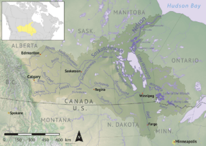
This basin is almost entirely within Canada. It covers parts of the Canadian Prairies, Central Canada, and Northern Canada. A small part of it also reaches into the northern Midwestern United States. The basin is about 3,861,400 square kilometers (1,490,900 square miles) in size.
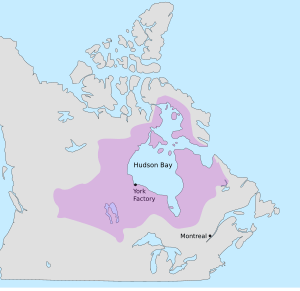
Historically, the Hudson Bay drainage basin was almost the same as a territory called Rupert's Land. This land was claimed by the Hudson's Bay Company in the 1600s. It was a perfect place for the early North American fur trade because of all its rivers.
Contents
Where the Basin Begins and Ends
The Hudson Bay connects to the Labrador Sea, which is part of the Atlantic Ocean. This connection happens at the mouth of the Hudson Strait. This strait is located between Resolution Island and Cape Chidley on the Labrador Peninsula.
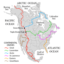
The very farthest points of the basin to the southwest are on the Continental Divide of the Americas. This divide is a line that separates which ocean water flows into. The basin's western and northern edge is called the Arctic Divide. Its southern and eastern edge is the Laurentian Divide.
Canadian and U.S. Regions in the Basin
The Hudson Bay drainage basin covers parts of many Canadian provinces and territories:
It also includes parts of these U.S. states:
Is Hudson Bay Part of the Arctic or Atlantic Ocean?
Sometimes, Hudson Bay is considered part of the Arctic Ocean. For example, some maps and organizations define it this way. This is because its outlet is close to the Arctic Circle.
However, other experts consider it part of the Atlantic Ocean. This is because more of its water flows into the Atlantic.
Major Rivers of the Basin
The biggest river system in the Hudson Bay drainage basin is the Nelson River. While the Nelson River itself is about 644 kilometers (400 miles) long, its many branches reach far west. Some of its farthest branches extend all the way to the Rocky Mountains.
From Hudson Bay to the Nelson River's farthest branch, the Bow River, the total length is about 2,575 kilometers (1,600 miles). The area it drains is huge, about 1,072,300 square kilometers (414,000 square miles).
Other important rivers in this system include:
- Saskatchewan (550 km or 340 mi)
- North Saskatchewan (1,287 km or 800 mi)
- South Saskatchewan (1,392 km or 865 mi)
- Red (880 km or 550 mi)
- Assiniboine (1,070 km or 660 mi)
- Red Deer (740 km or 460 mi)
Rivers Flowing into Hudson, James, and Ungava Bays
Here is a list of the main rivers that flow into Hudson Bay, James Bay, and Ungava Bay. They are listed clockwise around the coastline, starting from Quebec.
Rivers of Quebec
- George
- Whale
- False
- Koksoak
- Leaf
- Arnaud
- Kovik
- Povungnituk
- Kogaluc
- Innuksuac
- Qikirtaluup Kuunga
- Nastapoka
- Little Whale
- Great Whale
- Roggan
- La Grande
- Eastmain
- Pontax
- Rupert
- Broadback
- Nottaway
- Harricana
Rivers of Ontario
Rivers of Manitoba
- Geillini
- Thlewiaza
- Tha-anne
- Ferguson
- Wilson
- Thelon
- Lorillard
- Brown
- Kirchoffer (Southampton Island)
- Koukdjuak (Baffin Island)
See also
- Watersheds of North America
- List of rivers of Canada
- List of rivers of the United States


