
List of World Heritage Sites in Western Asia facts for kids
The UNESCO (United Nations Educational, Scientific and Cultural Organization) has named 95 special places, called World Heritage Sites, in 18 countries across Western Asia. These countries include Armenia, Azerbaijan, Bahrain, Cyprus, Georgia, Iran, Iraq, Israel, Jordan, Lebanon, Oman, Palestine, Saudi Arabia, Syria, Turkey, United Arab Emirates, Qatar, and Yemen. Even though Egypt is partly in Western Asia, its World Heritage Sites are listed under Africa. One site is located in Jerusalem. Interestingly, Kuwait is the only country in this region that doesn't have any World Heritage Sites. The Arabian Oryx Sanctuary in Oman was a World Heritage Site in 1994 but was later removed from the list in 2007 because Oman greatly reduced its protected area.
Iran has the most World Heritage Sites in this region, with 27 amazing places. The very first sites from this area to be recognized by UNESCO were Persepolis, Meidan Emam, Esfahan, and Tchogha Zanbil in Iran, along with the Ancient City of Damascus in Syria. Every year, the World Heritage Committee decides which new places to add to the list. They might also remove sites if they no longer meet the special rules. To be chosen, a site must meet at least one of ten criteria. Six of these are for cultural heritage (like old buildings or traditions), and four are for natural heritage (like unique landscapes or wildlife). Some sites are "mixed sites," meaning they have both cultural and natural importance. In Western Asia, there are 67 cultural sites, 1 natural site, and 3 mixed sites.
Sometimes, the World Heritage Committee might say a site is endangered. This means that something is threatening the special features that made the site famous. Currently, seven sites in Western Asia are listed as endangered. One site, Bahla Fort, was on this list before but is now safe. UNESCO has also thought about adding other sites to the danger list.
What Do the Table Columns Mean?
The table below lists all the World Heritage Sites in Western Asia. You can sort the table by clicking the small arrows at the top of each column. This helps you find information easily!
- Site: This is the official name of the World Heritage Site.
- Location: This tells you where the site is, like the city or region and its exact coordinates.
- Criteria: This shows why the site was chosen. It could be for its cultural importance (like old buildings or history) or its natural beauty (like unique landscapes).
- Area: This is the size of the site in hectares (ha) and acres. Sometimes, there's also a "buffer zone," which is an extra protected area around the main site. If it says "—", it means no specific size has been published.
- Year: This is the year the site was added to the World Heritage List.
- Description: This gives you a short explanation about the site and why it's important. It also mentions if a site is currently in danger.
Amazing World Heritage Sites
† In danger
| Site | Image | Location | Criteria | Area ha (acre) |
Year | Description | Refs |
|---|---|---|---|---|---|---|---|
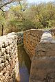
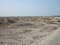
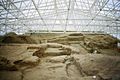
| Aflaj Irrigation Systems of Oman |  |
Sharqiyah and Batinah Regions, 22°59′56″N 57°32′10″E / 22.99889°N 57.53611°E |
Cultural: (v) |
1,456 (3,600); buffer zone 16,404 (40,540) | 2006 | These are ancient water channels that Omanis used to bring water from underground sources to their farms and villages. They show amazing engineering skills from a long time ago. | |
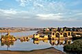
| Al-Ahsa |  |
Al-Ahsa Governorate, 25°25′46″N 49°37′19″E / 25.42944°N 49.62194°E |
Cultural: (iii)(iv)(v) |
8,544 (21,110); buffer zone 21,556 (53,270) | 2018 | This is a huge oasis with millions of palm trees. It has been a farming area for thousands of years and shows how people lived and worked in the desert. | |
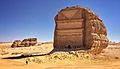
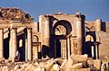
| Al-Hijr Archaeological Site (Madâin Sâlih) |  |
Al Madinah Province, 26°47′1″N 37°57′18″E / 26.78361°N 37.95500°E |
Cultural: (ii)(iii) |
1,621 (4,010); buffer zone 1,659 (4,100) | 2008 | This ancient city was built by the Nabataean people. It has impressive tombs carved into rock cliffs, similar to Petra in Jordan. | |
| Al Zubarah Archaeological Site |  |
Madinat ash Shamal, 25°58′41″N 51°1′47″E / 25.97806°N 51.02972°E |
Cultural: (iii)(iv)(v) |
416 (1,030); buffer zone 7,196 (17,780) | 2013 | This is a well-preserved example of an 18th-century trading town. It shows how people lived and traded in the Persian Gulf. | |
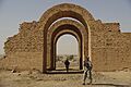
| Ancient City of Aleppo† |  |
Aleppo Governorate, 36°14′0″N 37°10′0″E / 36.23333°N 37.16667°E |
Cultural: (iii)(iv) |
350 (860) | 1986 | Aleppo is one of the oldest continuously inhabited cities in the world. It has a rich history and many old buildings, but it is currently in danger due to conflict. | |
| Ancient City of Bosra† |  |
Daraa Governorate, 32°31′5″N 36°28′54″E / 32.51806°N 36.48167°E |
Cultural: (i)(iii)(vi) |
— | 1980 | This ancient city was an important stop on trade routes. It has a large Roman theatre and early Christian ruins, but it is currently in danger due to conflict. | |
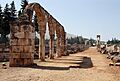
| Ancient City of Damascus† |  |
Damascus Governorate, 33°30′41″N 36°18′23″E / 33.51139°N 36.30639°E |
Cultural: (i)(ii)(iii)(iv)(vi) |
86 (210) | 1979 | Damascus is one of the oldest cities in the world, with a history spanning thousands of years. It has many historical buildings and is important to several religions, but it is currently in danger due to conflict. | |
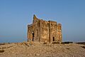
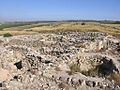
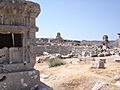
| Ancient City of Qalhat |  |
Ash Sharqiyah South Governorate, 22°42′N 59°22′E / 22.700°N 59.367°E |
Cultural: (ii)(iii) |
75.82 (187.4); buffer zone 170.09 (420.3) | 2018 | This ancient port city was a major trading hub between the 11th and 15th centuries. It shows how important trade was in the region long ago. | |
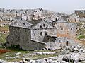
| Ancient Villages of Northern Syria† |  |
Aleppo and Idlib Governorates, 36°20′3″N 36°50′39″E / 36.33417°N 36.84417°E |
Cultural: (iii)(iv)(v) |
12,290 (30,400) | 2011 | These are hundreds of abandoned villages from the 1st to 7th centuries. They show how people lived in ancient times, but they are currently in danger due to conflict. | |
| Anjar |  |
Beqaa Governorate, 33°43′33″N 35°55′47″E / 33.72583°N 35.92972°E |
Cultural: (iii)(iv) |
— | 1984 | Anjar is a unique example of an Umayyad city from the 8th century. Its ruins show a well-planned city with streets and buildings. | |
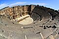
| Archaeological Site of Troy |  |
Çanakkale Province, 39°57′23″N 26°14′20″E / 39.95639°N 26.23889°E |
Cultural: (ii)(iii)(vi) |
158 (390) | 1998 | Troy is a famous archaeological site known from ancient Greek stories, especially the Trojan War. It has many layers of ruins from different time periods. | |
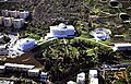
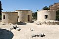
| Archaeological Sites of Bat, Al-Khutm and Al-Ayn |  |
Ad Dhahirah Region, 23°16′11″N 56°44′42″E / 23.26972°N 56.74500°E |
Cultural: (iii)(iv) |
— | 1988 | These sites have ancient tombs and settlements from the 3rd millennium BC. They show early human settlements and burial practices in Oman. | |
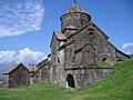
| Armenian Monastic Ensembles of Iran |  |
West Azerbaijan, 38°58′44″N 45°28′24″E / 38.97889°N 45.47333°E |
Cultural: (ii)(iii)(vi) |
129 (320); buffer zone 655 (1,620) | 2008 | This site includes several ancient Armenian monasteries and churches. They are important examples of Armenian architecture and religious traditions. | |
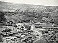
| Ashur (Qal'at Sherqat)† |
.jpg) |
Salah ad Din Governorate, 35°27′32″N 43°15′35″E / 35.45889°N 43.25972°E |
Cultural: (iii)(iv) |
70 (170); buffer zone 100 (250) | 2003 | Ashur was an ancient Assyrian capital and religious center. It has important ruins, but it is currently in danger due to conflict. | |
| At-Turaif District in ad-Dir'iyah |  |
Riyadh Province, 24°44′3″N 46°34′21″E / 24.73417°N 46.57250°E |
Cultural: (ii)(iii) |
29 (72) | 2008 | This was the first capital of the Saudi Dynasty. It shows the unique architecture of the region and how the city developed. | |
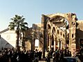
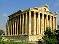
| Baalbek |  |
Baalbek-Hermel Governorate, 34°0′25″N 36°12′18″E / 34.00694°N 36.20500°E |
Cultural: (i)(iv) |
— | 1984 | Baalbek is home to some of the most impressive Roman temple ruins in the world. The huge columns and detailed carvings are amazing to see. | |
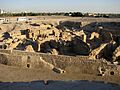
| Babylon |  |
Hillah, 32°32′11″N 44°25′15″E / 32.53639°N 44.42083°E |
Cultural: (iii)(vi) |
1,054.3 (2,605) ; buffer zone 154.5 (382) | 2019 | Babylon was one of the most famous cities of the ancient world. It was known for its Hanging Gardens and impressive buildings. | |
| Bahá’i Holy Places in Haifa and the Western Galilee |  |
Haifa and North District, 32°49′46″N 34°58′18″E / 32.82944°N 34.97167°E |
Cultural: (iii)(vi) |
63 (160); buffer zone 255 (630) | 2008 | These beautiful gardens and buildings are important holy places for the Baháʼí Faith. They are known for their stunning design and peaceful atmosphere. | |
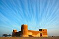
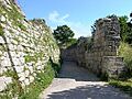
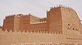
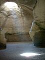
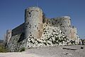
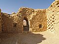
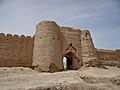
| Bahla Fort |  |
Ad Dakhiliyah Region, 22°57′51″N 57°18′4″E / 22.96417°N 57.30111°E |
Cultural: (iv) |
— | 1987 | This large fort was built in the 13th and 14th centuries. It's a great example of Omani military architecture and was once listed as endangered. | |
| Bam and its Cultural Landscape |  |
Kerman, 29°07′00.68″N 58°22′06.51″E / 29.1168556°N 58.3684750°E |
Cultural: (ii)(iii)(iv)(v) |
— | 2004 | Bam is a huge ancient city made of mud bricks, with a large fortress. It shows how cities were built in the desert thousands of years ago. | |
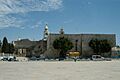
| Baptism Site “Bethany Beyond the Jordan” (Al-Maghtas) | .JPG) |
Jordan River, 31°50′13″N 35°32′50″E / 31.83694°N 35.54722°E |
Cultural: (iii)(vi) |
294 (730); buffer zone 957 (2,360) | 2015 | This site is believed to be where John the Baptist baptized Jesus. It's a very important religious site for Christians. | |
| Biblical tells - Megiddo, Hazor, Beer Sheba |  |
32°35′50″N 35°10′56″E / 32.59722°N 35.18222°E |
Cultural: (ii)(iii)(iv)(vi) |
96 (240); buffer zone 604 (1,490) | 2005 | These are ancient mounds (tells) that contain the remains of important biblical cities. They show how cities were built and rebuilt over thousands of years. | |
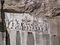
| Bisotun |  |
Kermanshah, 34°23′18″N 47°26′12″E / 34.38833°N 47.43667°E |
Cultural: (ii)(iii) |
187 (460); buffer zone 361 (890) | 2006 | This site has a large rock carving and inscription from ancient Persia. It's like a giant history book carved into a mountain. | |
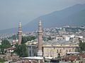
| Bursa and Cumalıkızık: the Birth of the Ottoman Empire |  |
City of Bursa and village of Cumalıkızık, Bursa Province, 40°11′5″N 29°3′44″E / 40.18472°N 29.06222°E |
Cultural: (i)(ii)(iii)(iv)(vi) |
193 (480) | 2014 | These sites show the early development of the Ottoman Empire, with mosques, bridges, and a traditional village. | |
| Byblos |  |
Mount Lebanon Governorate, 34°7′9″N 35°38′51″E / 34.11917°N 35.64750°E |
Cultural: (iii)(iv)(vi) |
— | 1984 | Byblos is one of the oldest continuously inhabited cities in the world. It was an important port city and played a key role in spreading the alphabet. | |
| Caves of Maresha and Bet-Guvrin in the Judean Lowlands as a Microcosm of the Land of the Caves |  |
Southern District, 31°36′0″N 34°53′44″E / 31.60000°N 34.89556°E |
Cultural: (V) |
259 (640) | 2014 | This site has a huge network of man-made caves. They show how people used to live, work, and bury their dead underground. | |
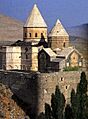
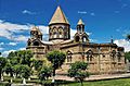
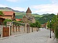
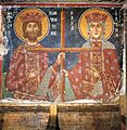
| Cathedral and Churches of Echmiatsin and the Archaeological Site of Zvartnots |  |
Armavir Province, 40°9′34″N 44°17′43″E / 40.15944°N 44.29528°E |
Cultural: (ii)(iii) |
74 (180) | 2000 | These are important early Christian churches in Armenia. They show unique Armenian church architecture and history. | |
| Choirokoitia |  |
Larnaca District, 34°47′54″N 33°20′36″E / 34.79833°N 33.34333°E |
Cultural: (ii)(iii)(iv) |
— | 1998 | This is a very old Neolithic settlement, showing how people lived in Cyprus thousands of years ago. You can see the remains of their round houses. | |
| Birthplace of Jesus: Church of the Nativity and the Pilgrimage Route, Bethlehem |  |
Bethlehem Governorate, 31°42′16″N 35°12′28″E / 31.70444°N 35.20778°E |
Cultural: (iv), (vi) |
2.98 (7.4) | 2012 | This site is traditionally believed to be the birthplace of Jesus. It's a very important religious site for Christians around the world. | |
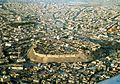
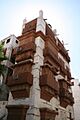
| Erbil Citadel |  |
36°11′28″N 44°0′33″E / 36.19111°N 44.00917°E |
Cultural: (iv) |
16 (40); buffer zone 268 (660) | 2014 | The Erbil Citadel is a large ancient mound in the middle of the city, believed to be one of the oldest continuously inhabited places on Earth. | |
| City of Safranbolu |  |
City and district of Safranbolu, Karabük Province, 41°15′36″N 32°41′23″E / 41.26000°N 32.68972°E |
Cultural: (ii)(iv)(v) |
193 (480) | 1994 | Safranbolu is a well-preserved Ottoman city. Its traditional houses and buildings show what life was like during the Ottoman Empire. | |
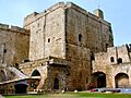
| Crac des Chevaliers and Qal’at Salah El-Din† |  |
Homs and Latakia Governorates, 34°46′54″N 36°15′47″E / 34.78167°N 36.26306°E |
Cultural: (ii)(iv) |
9 (22) | 2006 | These are two impressive Crusader castles. They show the military architecture of the Middle Ages, but they are currently in danger due to conflict. | |
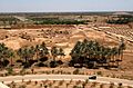
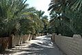
| Cultural Sites of Al Ain (Hafit, Hili, Bidaa Bint Saud and Oases Areas) |  |
24°4′4″N 55°48′23″E / 24.06778°N 55.80639°E |
Cultural: (iii)(iv)(v) |
4,945 (12,220); buffer zone 7,605 (18,790) | 2011 | These sites include ancient tombs, oases, and archaeological remains. They show how people lived and used the desert environment for thousands of years. | |
| Dilmun Burial Mounds |  |
Northern Governorate and Southern Governorate, 26°8′59″N 50°30′46″E / 26.14972°N 50.51278°E |
Cultural: (iii)(iv) |
168.45 (416.2) ; buffer zone 383.46 (947.6) | 2019 | These are thousands of ancient burial mounds from the Dilmun civilization. They show how people were buried and their beliefs about the afterlife. | |
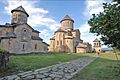
| Gelati Monastery |  |
Imereti, 42°17′41″N 42°46′6″E / 42.29472°N 42.76833°E |
Cultural: (iv) |
4.2 (10); buffer zone 1,246 (3,080) | 1994 | This medieval monastery is known for its beautiful mosaics and wall paintings. It was an important center of learning in Georgia. | |
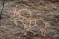
| Gobustan Rock Art Cultural Landscape |  |
Garadagh and Absheron districts, 40°7′30″N 49°22′30″E / 40.12500°N 49.37500°E |
Cultural: (iii) |
537 (1,330); buffer zone 3,096 (7,650) | 2007 | This site has thousands of ancient rock carvings (petroglyphs) that show scenes of prehistoric life, animals, and dances. | |
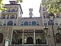
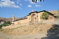
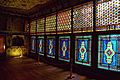
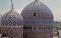
| Golestan Palace |  |
Tehran, 35°40′49″N 51°25′14″E / 35.68028°N 51.42056°E |
Cultural: (i)(ii)(iii)(iv) |
5.3 (13); buffer zone 26 (64) | 2013 | This beautiful palace complex was the seat of the Qajar dynasty. It shows a mix of Persian and European architectural styles. | |
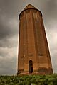
| Gonbad-e Qabus |  |
Golestan, 37°15′29″N 55°10′8″E / 37.25806°N 55.16889°E |
Cultural: (i)(ii)(iii)(iv) |
1.48 (3.7); buffer zone 18 (44) | 2012 | This tall, conical brick tower from the 11th century is a great example of early Islamic architecture in Iran. | |
| Great Mosque and Hospital of Divriği | .jpg) |
city and district of Divriği, Sivas Province, 39°22′25″N 38°7′25″E / 39.37361°N 38.12361°E |
Cultural: (i)(iv) |
2,016 (4,980) | 1985 | This complex includes a mosque and a hospital from the 13th century. It's known for its amazing stone carvings and unique architecture. | |
| Göbekli Tepe |  |
Şanlıurfa Province, 37°13′23″N 38°55′21″E / 37.22306°N 38.92250°E |
Cultural: (i)(ii)(iv) |
126 (310); buffer zone 461 (1,140) | 2018 | Göbekli Tepe is one of the oldest known temples in the world, built even before farming began. It has huge carved stone pillars. | |
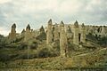
| Göreme National Park and the Rock Sites of Cappadocia |  |
Nevşehir Province in Central Anatolia Region, 38°40′0″N 34°51′0″E / 38.66667°N 34.85000°E |
Mixed: (i)(iii)(v)(vii) |
9,576 (23,660) | 1985 | This unique landscape has "fairy chimneys" (rock formations) and ancient cave churches carved into the soft rock. It's both naturally beautiful and culturally rich. | |
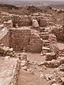
| Hatra |  |
Ninawa Governorate, 35°35′17″N 42°43′6″E / 35.58806°N 42.71833°E |
Cultural: (ii)(iii)(iv)(vi) |
324 (800) | 1985 | Hatra was an ancient city with impressive temples and fortifications. It shows a mix of Greek, Roman, and Eastern architectural styles. | |
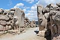
| Hattusha: the Hittite Capital |  |
Sungurlu, Çorum Province, 40°0′50″N 34°37′14″E / 40.01389°N 34.62056°E |
Cultural: (i)(ii)(iii)(iv) |
268 (660) | 1986 | Hattusha was the capital of the Hittite Empire. It has impressive city walls, temples, and royal residences. | |
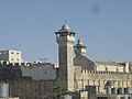
| Hebron/Al-Khalil Old Town† | -Mosche.JPG) |
Hebron Governorate, 31°31′30″N 35°06′30″E / 31.52500°N 35.10833°E |
Cultural: (ii)(iv)(vi) |
20.6 (51) | 2017 | This old town is important to Judaism, Christianity, and Islam. It has a special building over the tombs of Abraham and his family. It is currently in danger. | |
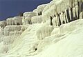
| Hierapolis-Pamukkale |  |
Denizli Province, 37°55′26″N 29°7′24″E / 37.92389°N 29.12333°E |
Mixed: (iii)(iv)(vii) |
1,077 (2,660) | 1988 | This site combines the ancient city of Hierapolis with the stunning white terraces of Pamukkale, formed by mineral-rich hot springs. It's both a natural wonder and a historical site. | |
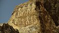
| Ḥimā Cultural Area |  |
Najran Province, 18°14′55″N 44°27′6″E / 18.24861°N 44.45167°E |
Cultural: (iii) |
242.17 (598.4); buffer zone 31,757.83 (78,475.3) | 2021 | This area has a large collection of rock art and inscriptions from ancient times. It shows how people lived and communicated thousands of years ago. | |
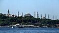
| Historic Areas of Istanbul |  |
Istanbul city and Istanbul Province, 41°0′30″N 28°58′48″E / 41.00833°N 28.98000°E |
Cultural: (i)(ii)(iii)(iv) |
678 (1,680) | 1985 | Istanbul was the capital of the Byzantine and Ottoman Empires. It has many famous landmarks like the Hagia Sophia and Blue Mosque, showing its rich history. | |
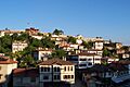
| Historic Centre of Sheki with the Khan's Palace |  |
Sheki, 41°12′12″N 47°11′15″E / 41.20333°N 47.18750°E |
Cultural: (ii)(v) |
120.5 (298) ; buffer zone 146 (360) | 2019 | This historic city was an important stop on the Silk Road. It has beautiful traditional houses and the stunning Khan's Palace. | |
| Historic Jeddah, the Gate to Makkah |  |
Jeddah, 21°29′2″N 39°11′15″E / 21.48389°N 39.18750°E |
Cultural: (ii)(iv)(vi) |
18 (44) ; buffer zone 114 (280) | 2014 | This old part of Jeddah was a major port for pilgrims going to Mecca. It has unique multi-story buildings made of coral stone. | |
| Historical Monuments of Mtskheta | .jpg) |
Mtskheta-Mtianeti, 41°51′N 44°43′E / 41.850°N 44.717°E |
Cultural: (iii)(iv) |
— | 1994 | Mtskheta was the ancient capital of Georgia and is a very important religious center. It has several historic churches. | |
| Historic Town of Zabid† |  |
Al Hudaydah Governorate, 14°11′53″N 43°19′48″E / 14.19806°N 43.33000°E |
Cultural: (iii) |
— | 1993 | Zabid was an important center of Islamic learning. It has many mosques and houses with unique architecture, but it is currently in danger due to conflict. | |
| Hyrcanian Forests | _4.jpg) |
Golestan, Mazandaran and Gilan Province, 37°25′17.3″N 55°43′27.4″E / 37.421472°N 55.724278°E |
Natural: (ix) |
129,484.74 (319,963.8) ; buffer zone 177,128.79 (437,694.8) | 2019 | These ancient forests along the Caspian Sea are home to many unique plant and animal species. They are a rare example of temperate broadleaf forests. | |
| Incense Route – Desert Cities in the Negev |  |
Negev, 30°32′28″N 35°9′39″E / 30.54111°N 35.16083°E |
Cultural: (iii)(v) |
— | 2005 | This route was used for trading frankincense and myrrh in ancient times. It includes ancient desert cities and forts. | |
| Land of Frankincense |  |
Dhofar Governorate, 18°15′12″N 53°38′51″E / 18.25333°N 53.64750°E |
Cultural: (iii)(iv) |
850 (2,100); buffer zone 1,243 (3,070) | 2000 | This site includes ancient frankincense trees, trading ports, and oases. It shows the history of the frankincense trade, which was very important long ago. | |
| Palestine: Land of Olives and Vines – Cultural Landscape of Southern Jerusalem, Battir† |  |
Bethlehem Governorate, 31°43′11″N 35°7′50″E / 31.71972°N 35.13056°E |
Cultural: (iv), (v) |
2014 | This area has ancient agricultural terraces where olives and grapes have been grown for centuries. It shows how people have managed the land for farming, but it is currently in danger. | ||
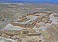
| Masada |  |
South District, 31°18′49″N 35°21′10″E / 31.31361°N 35.35278°E |
Cultural: (iii)(iv)(vi) |
276 (680); buffer zone 28,965 (71,570) | 2001 | Masada is an ancient fortress on a high plateau. It's famous for its dramatic history and the story of Jewish rebels. | |
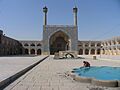
| Masjed-e Jāmé of Isfahan |  |
Isfahan, 32°40′11″N 51°41′7″E / 32.66972°N 51.68528°E |
Cultural: (ii) |
2.08 (5.1); buffer zone 19 (47) | 2012 | This is one of the oldest and largest mosques in Iran. It shows the development of Islamic architecture over many centuries. | |
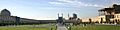
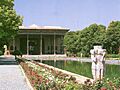
| Meidan Emam, Esfahan | Isfahan, 32°39′27″N 51°40′40″E / 32.65750°N 51.67778°E |
Cultural: (i)(v)(vi) |
— | 1979 | This huge public square is surrounded by impressive buildings, including mosques and a palace. It's a masterpiece of Persian architecture. | ||
| Monasteries of Haghpat and Sanahin |  |
Haghpat and Sanahin, Lori Province, 41°5′42″N 44°42′37″E / 41.09500°N 44.71028°E |
Cultural: (ii)(iv) |
2.65 (6.5); buffer zone 24 (59) | 1996 | These two medieval monasteries are important examples of Armenian religious architecture. They were centers of learning and art. | |
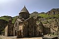
| Monastery of Geghard and the Upper Azat Valley |  |
near Goght, Kotayk Province, 40°9′32″N 44°47′48″E / 40.15889°N 44.79667°E |
Cultural: (ii) |
2.70 (6.7) | 2000 | This monastery is partly carved out of the rock face of a mountain. It's a unique example of Armenian medieval architecture and art. | |
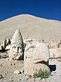
| Nemrut Dağ |  |
Adiyaman Province, 38°2′12″N 38°45′49″E / 38.03667°N 38.76361°E |
Cultural: (i)(iii)(iv) |
11 (27) | 1987 | This site has a huge tomb-sanctuary built for King Antiochus I. It features giant stone heads of gods and kings. | |
| Neolithic Site of Çatalhöyük |  |
Central Anatolia Region, 37°40′0″N 32°49′41″E / 37.66667°N 32.82806°E |
Cultural: (iii)(iv) |
37 (91); buffer zone 111 (270) | 2012 | Çatalhöyük is a very large and well-preserved Neolithic settlement. It shows how early farming communities lived and built their homes. | |
| Old City of Acre |  |
Western Galilee, 32°55′42″N 35°5′2″E / 32.92833°N 35.08389°E |
Cultural: (ii)(iii)(v) |
63 (160) | 2001 | Acre is an ancient port city with a long history. It has well-preserved Crusader and Ottoman buildings, showing its importance over centuries. | |
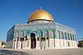
| Old City of Jerusalem and its Walls† |  |
Jerusalem 31°46′36.12″N 35°14′3.12″E / 31.7767000°N 35.2342000°E |
Cultural: (ii)(iii)(vi) |
— | 1981 | Jerusalem is a holy city for Judaism, Christianity, and Islam. It has many important religious sites and historical buildings, but it is currently in danger. | |
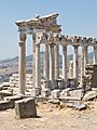
| Pergamon and its Multi-Layered Cultural Landscape |  |
Bergama, Izmir Province 39°7′33″N 27°10′48″E / 39.12583°N 27.18000°E |
Cultural: (i)(ii)(iii)(iv)(vi) |
333 (820); buffer zone 477 (1,180) | 2014 | Pergamon was an important ancient Greek and Roman city. It has impressive ruins, including a theatre and a library. | |
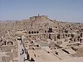
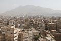
| Old City of Sana'a |  |
Sana'a Governorate, 15°21′20″N 44°12′29″E / 15.35556°N 44.20806°E |
Cultural: (iv)(v)(vi) |
— | 1986 | Sana'a is an ancient city with unique architecture, including multi-story houses decorated with geometric patterns. | |
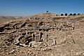
| Shahr-i Sokhta |  |
Sistan and Baluchestan Province, 30°35′38″N 61°19′40″E / 30.59389°N 61.32778°E |
Cultural: (ii)(iii)(iv) |
1,456 (3,600); buffer zone 2,200 (5,400) | 2014 | This is an ancient Bronze Age city that was a major trading center. It provides important information about early urban societies. | |
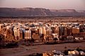
| Old Walled City of Shibam |  |
Hadhramaut Governorate, 15°55′37″N 48°37′36″E / 15.92694°N 48.62667°E |
Cultural: (iii)(iv)(v) |
— | 1982 | Shibam is known as the "Manhattan of the Desert" because of its tall, mud-brick buildings. It's a great example of early urban planning. | |
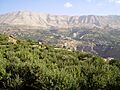
| Ouadi Qadisha (the Holy Valley) and the Forest of the Cedars of God (Horsh Arz el-Rab) |  |
North Lebanon Governorate, 34°14′36″N 36°2′56″E / 34.24333°N 36.04889°E |
Cultural: (iii)(iv) |
— | 1998 | This beautiful valley has ancient Christian monasteries carved into the cliffs. The Cedars of God are a small but important forest of ancient cedar trees. | |
| Painted Churches in the Troodos Region |  |
Troodos Mountains, Limassol and Nicosia Districts, 34°55′13″N 33°5′45″E / 34.92028°N 33.09583°E |
Cultural: (iii)(vi) |
— | 1985 | These churches have amazing wall paintings from the Byzantine period. They are hidden in the mountains and show unique religious art. | |
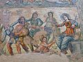
| Paphos |  |
Paphos District, 34°45′30″N 32°24′20″E / 34.75833°N 32.40556°E |
Cultural: (iii)(vi) |
— | 1980 | Paphos was an ancient Greek and Roman city. It has impressive ruins, including beautiful mosaics that tell stories from mythology. | |
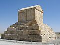
| Pasargadae |  |
Pars, 30°11′38″N 53°10′2″E / 30.19389°N 53.16722°E |
Cultural: (1)(ii)(iii)(iv) |
160 (400); buffer zone 7,127 (17,610) | 2004 | Pasargadae was the first capital of the Achaemenid Empire. It includes the tomb of Cyrus the Great, a very important ancient Persian ruler. | |
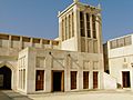
| Pearling, Testimony of an Island Economy |  |
Muharraq Governorate, 26°14′29″N 50°36′49″E / 26.24139°N 50.61361°E |
Cultural: (iii) |
35,087 (86,700); buffer zone 95,876 (236,910) | 2012 | This site tells the story of Bahrain's pearling industry, which was very important to its economy for centuries. It includes oyster beds and old merchant houses. | |
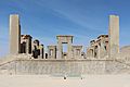
| Persepolis |  |
Fars, 29°56′4″N 52°52′25″E / 29.93444°N 52.87361°E |
Cultural: (i)(iii)(vi) |
13 (32) | 1979 | Persepolis was the ceremonial capital of the Achaemenid Empire. It has magnificent palace ruins with detailed carvings. | |
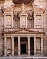
| Petra |  |
Ma'an Governorate, 30°19′50″N 35°26′36″E / 30.33056°N 35.44333°E |
Cultural: (i)(iii)(iv) |
— | 1985 | Petra is a famous ancient city carved into pink sandstone cliffs. It was the capital of the Nabataean kingdom and is known for its stunning architecture. | |
| Qal’at al-Bahrain – Ancient Harbour and Capital of Dilmun |
 |
Northern Governorate, 26°13′59″N 50°31′20″E / 26.23306°N 50.52222°E |
Cultural: (ii)(iii)(iv) |
32 (79); buffer zone 1,238 (3,060) | 2005 | This ancient mound was once the capital of the Dilmun civilization. It has layers of ruins from different periods, showing its long history as a port. | |
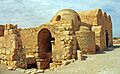
| Quseir Amra |  |
Zarqa Governorate, 31°48′7″N 36°35′9″E / 31.80194°N 36.58583°E |
Cultural: (i)(iii)(iv) |
— | 1985 | This desert castle is famous for its beautiful frescoes (wall paintings) from the early Islamic period. They show scenes of daily life and hunting. | |
| Rock Art in the Hail Region |  |
Hail Region, 28°2′16.8″N 40°32′40.92″E / 28.038000°N 40.5447000°E |
Cultural: (i)(iii) |
2,043.8 (5,050); buffer zone 3,609.5 (8,919) | 2015 | This site has thousands of ancient rock carvings and inscriptions. They provide clues about the lives of people who lived in the desert for thousands of years. | |
| Samarra Archaeological City† |
 |
Salah ad Din Governorate, 34°20′28″N 43°49′25″E / 34.34111°N 43.82361°E |
Cultural: (ii)(iii)(iv) |
15,058 (37,210); buffer zone 31,414 (77,630) | 2007 | Samarra was once the capital of the Abbasid Caliphate. It has a huge spiral minaret and other impressive ruins, but it is currently in danger due to conflict. | |
| Sassanid Archaeological Landscape of Fars Region |  |
Fars Province, 29°46′39″N 51°34′13″E / 29.77750°N 51.57028°E |
Cultural: (ii)(iii)(iv) |
639 (1,580); buffer zone 12,715 (31,420) | 2018 | This area has many archaeological sites from the Sassanid Empire. They show the art, architecture, and urban planning of this ancient Persian empire. | |
| Selimiye Mosque and its Social Complex |  |
Edirne, East Thrace, 41°40′40″N 26°33′34″E / 41.67778°N 26.55944°E |
Cultural: (i)(iv) |
2.50 (6.2); buffer zone 38 (94) | 2011 | This mosque is a masterpiece of Ottoman architecture, designed by the famous architect Mimar Sinan. It has a huge dome and tall minarets. | |
| Sheikh Safi al-din Khānegāh and Shrine Ensemble in Ardabil |  |
Ardabil, Ardabil Province, 38°14′55″N 48°17′29″E / 38.24861°N 48.29139°E |
Cultural: (i)(ii)(iv) |
2.14 (5.3); buffer zone 13 (32) | 2010 | This is a spiritual retreat and burial place for a Sufi leader. It has beautiful Islamic architecture and decorations. | |
| Shushtar Historical Hydraulic System |  |
Khuzestan, 32°1′7″N 48°50′9″E / 32.01861°N 48.83583°E |
Cultural: (i)(ii)(v) |
240 (590); buffer zone 1,572 (3,880) | 2009 | This ancient water system is an engineering marvel. It includes bridges, dams, and canals that were used to manage water for farming. | |
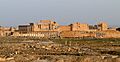
| Site of Palmyra† |  |
Homs Governorate, 34°33′15″N 38°16′0″E / 34.55417°N 38.26667°E |
Cultural: (i)(ii)(iv) |
0.36 (0.89) | 1980 | Palmyra was an ancient oasis city that was an important stop on trade routes. It has impressive Roman ruins, but it is currently in danger due to conflict. | |
| Sites of Human Evolution at Mount Carmel: The Nahal Me’arot / Wadi el-Mughara Caves |  |
Mount Carmel, 32°40′12″N 34°57′55″E / 32.67000°N 34.96528°E |
Cultural: (iii)(v) |
54 (130); buffer zone 370 (910) | 2012 | These caves contain evidence of human occupation from hundreds of thousands of years ago. They show how early humans lived and evolved. | |
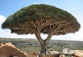
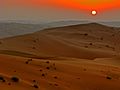
| Socotra Archipelago |  |
Hadhramaut Governorate, 12°30′N 53°50′E / 12.500°N 53.833°E |
Natural: (x) |
410,460 (1,014,300); buffer zone 1,740,958 (4,302,000) | 2008 | This island group has unique plants and animals found nowhere else on Earth, like the dragon's blood tree. It's a natural wonder. | |
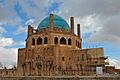
| Soltaniyeh |  |
Zanjan, 36°26′7″N 48°47′48″E / 36.43528°N 48.79667°E |
Cultural: (ii)(iii)(iv) |
790 (2,000); buffer zone 350 (860) | 2005 | This site has a huge dome, one of the largest brick domes in the world. It was built as a mausoleum for a Mongol ruler. | |
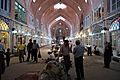
| Tabriz Historic Bazaar Complex |  |
Tabriz, 38°4′53″N 46°17′35″E / 38.08139°N 46.29306°E |
Cultural: (ii)(iii)(iv) |
29 (72); buffer zone 75 (190) | 2010 | This is one of the oldest and largest covered bazaars in the world. It was an important trading center on the Silk Road. | |
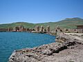
| Takht-e Soleyman |  |
West Azerbaijan, 36°36′14″N 47°14′6″E / 36.60389°N 47.23500°E |
Cultural: (i)(ii)(iii)(iv)(vi) |
10 (25); buffer zone 7,438 (18,380) | 2003 | This archaeological site includes a Zoroastrian fire temple and other ancient ruins. It's built around a volcanic lake. | |
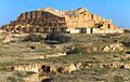
| Tchogha Zanbil |  |
Khuzestan, 32°5′0″N 48°32′0″E / 32.08333°N 48.53333°E |
Cultural: (iii)(iv) |
— | 1979 | This is an ancient Elamite ziggurat (a type of stepped pyramid). It's one of the few ziggurats outside of Mesopotamia. | |
| The Persian Garden |  |
Pars, 30°10′0″N 53°10′0″E / 30.16667°N 53.16667°E |
Cultural: (i)(ii)(iii)(iv)(vi) |
716 (1,770); buffer zone 9,740 (24,100) | 2011 | This site includes nine different examples of traditional Persian gardens. They are known for their beautiful design, water features, and symbolism. | |
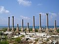
| Tyre |  |
South Lebanon Governorate, 33°16′15″N 35°11′46″E / 33.27083°N 35.19611°E |
Cultural: (iii)(vi) |
154 (380) | 1984 | Tyre was an ancient Phoenician city and a major port. It has impressive Roman and Crusader ruins. | |
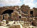
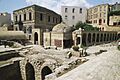
| Um er-Rasas (Kastrom Mefa'a) |  |
Amman Governorate, 31°30′6″N 35°55′14″E / 31.50167°N 35.92056°E |
Cultural: (i)(iv)(vi) |
24 (59); buffer zone 90 (220) | 2005 | This archaeological site has ruins from Roman, Byzantine, and early Islamic periods. It's known for its beautiful mosaic floors. | |
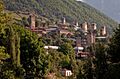
| Upper Svaneti |  |
Mestia District, Samegrelo-Zemo Svaneti, 42°54′59″N 43°0′41″E / 42.91639°N 43.01139°E |
Cultural: (iv)(v) |
1.06 (2.6); buffer zone 19 (47) | 1996 | This mountain region has unique medieval stone tower-houses. They were built for defense and are a special part of Georgian culture. | |
| ‘Uruq Bani Mu’arid Protected Area |  |
Najran, Riyadh, |
Natural: (vii)(ix) |
1,276,500 (3,154,000); buffer zone 80,600 (199,000) | 2023 | This vast desert area is home to unique sand dunes and wildlife, including the Arabian oryx. It's a key place for desert ecosystems. | |
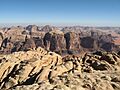
| Wadi Rum Protected Area |  |
Aqaba Governorate, 29°38′N 35°26′E / 29.633°N 35.433°E |
Mixed: (iii)(v)(vii) |
74,180 (183,300); buffer zone 59,177 (146,230) | 2011 | Wadi Rum is a stunning desert landscape with towering sandstone mountains and ancient rock carvings. It's known for its natural beauty and historical importance. | |
| Walled City of Baku with the Shirvanshah's Palace and Maiden Tower |  |
Absheron Peninsula, 40°22′0″N 49°50′0″E / 40.36667°N 49.83333°E |
Cultural: (iv) |
22 (54) | 2000 | This ancient walled city has a rich history, with a royal palace and a mysterious tower. It shows the unique architecture of Azerbaijan. | |
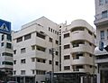
| White City of Tel-Aviv—the Modern Movement |  |
Tel Aviv, 32°4′0″N 34°47′0″E / 32.06667°N 34.78333°E |
Cultural: (ii)(iv) |
140 (350); buffer zone 197 (490) | 2003 | Tel Aviv's "White City" has many buildings built in the Bauhaus style. It's a great example of modern architecture from the 1930s. | |
| Xanthos-Letoon |  |
Muğla and Antalya Provinces, 36°20′6″N 29°19′13″E / 36.33500°N 29.32028°E |
Cultural: (ii)(iii) |
126 (310); buffer zone 63 (160) | 1988 | These are two ancient cities from the Lycian civilization. They have unique tombs and ruins that show the art and culture of this ancient people. |
Images for kids
-
Aflaj Irrigation Systems of Oman
-

Al-Ahsa Palm Oasis
-
Al-Hijr Archaeological Site
-
Zubarah Fort
-
Ancient City of Aleppo
-
Ancient City of Bosra
-
Ancient City of Damascus
-
Bibi Maryam mausoleum at Ancient City of Qalhat
-
Ancient Villages of Northern Syria
-
Anjar
-
Archaeological Site of Troy
-
Burial mound at the site of Al-Ayn
-
Saint Thaddeus Monastery, part of Armenian Monastic Ensembles of Iran
-
American soldiers on guard at the ruins of Ashur in 2008
-
At-Turaif District in ad-Dir'iyah
-
Baalbek
-
Babylon
-
Bahá’i Holy Places in Haifa
-
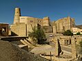
Bahla Fort
-
Bam and its Cultural Landscape
-
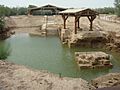
Baptism Site “Bethany Beyond the Jordan” (Al-Maghtas)
-
Biblical Tell Hazor
-
Bisotun Inscription
-
Bursa Grand Mosque
-
Byblos
-
Caves of Maresha and Bet-Guvrin
-
Etchmiadzin Cathedral
-
Choirokoitia
-
Church of the Nativity, Bethlehem
-
Erbil Citadel
-
Safranbolu traditional houses
-
Crac des Chevaliers
-
Al Ain Oasis
-
Dilmun Burial Mounds
-
Gelati Monastery
-
Gobustan Rock Art
-
Shams-ol-Emareh, Golestan Palace
-
Gonbad-e Qabus tower
-
Great Mosque and Hospital of Divriği
-
The ruins of Göbekli Tepe
-
Göreme Valley fairy chimneys
-
Hatra ruins
-
Lion Gate, Hattusha
-
Hebron-(Abraham)-Mosche.JPG
-
Pamukkale terraces
-
Bir Hima Rock Petroglyphs
-
Historic Areas of Istanbul
-
Khan's Palace, Sheki
-
Traditional house in Al Balad, Jeddah
-
Historical Monuments of Mtskheta
-
Historic Town of Zabid
-
Hyrcanian Forests
-
Incense Route – Desert Cities in the Negev
-
Ruins at Khor Rori, Land of Frankincense
-
Battir's ancient terraces
-
Masada room
-
Jameh Mosque of Isfahan courtyard
-
Meidan Emam, Esfahan
-
Haghpat Monastery
-
Monastery of Geghard
-
Mount Nemrut
-
Excavations at Çatalhöyük
-
Acre - Akko Tower
-
Temple Mount, Old City of Jerusalem
-
Pergamon
-
Old City of Sana'a
-
Shahr-i Sokhta ruins
-
Old Walled City of Shibam
-
Ouadi Qadisha (the Holy Valley)
-
Constantine and Helen, Church of Archangel Michael, Pedoulas
-
House of Aion, Paphos
-
Tomb of Cyrus the Great, Pasargadae
-
Isa Bin Ali House, Muharraq, Bahrain
-
Persepolis - Tachara
-
Al Khazneh, Petra
-
Qal’at al-Bahrain
-
Quseir Amra
-
Rock Art in the Hail Region
-
Great Mosque of Samarra
-
Persepolis ruins, Sassanid Archaeological Landscape of Fars Region
-
Selimiye Mosque, Edirne
-
The mausoleums of Sheikh Safi
-
Shushtar Bridge
-
Temple of Bel, Palmyra
-
Mount Carmel caves
-
Socotra dragon tree
-
Soltaniyeh dome
-
Carpet Bazaar of Tabriz
-
Takht-e Soleyman
-
Tchogha Zanbil
-
Chehel Sotoun, The Persian Garden
-
Tyre Al Mina
-
Umm Rasas House ruins
-
Mestia, Upper Svaneti
-
‘Uruq Bani Mu’arid Protected Area
-
Wadi Rum Protected Area
-
Hajji Gayyib bathhouse, Walled City of Baku
-
White building in Tel Aviv
-
Xanthos ruins
