
List of places of worship in Brighton and Hove facts for kids
The city of Brighton and Hove, located on England's south coast, is home to over 100 churches and other places of worship that are still in use today. These buildings serve many different Christian groups and other religions. There are also more than 50 older religious buildings that are still standing but are no longer used for their original purpose.
The history of Brighton and Hove goes back almost 1,000 years. However, the area only became a "city" in its current form in the year 2000. It started as a small fishing village called Bristelmestune, which was mentioned in the Domesday Book. In the 1700s, it was saved from decline by the support of the Prince Regent and wealthy British society. Hove, located to the west, also had humble beginnings. It grew quickly in the 1800s and merged with Brighton, though it always tried to keep its own identity. During the 1900s, both areas expanded by including nearby villages like Patcham, Hangleton, West Blatchington and Ovingdean. Each of these villages had an old church at its heart. New neighborhoods such as Mile Oak, Moulsecoomb and Saltdean were built on land bought by the city.
Except for the old parish churches of Brighton (St Nicholas) and Hove (St Andrew's), and those in the nearby villages now part of the city, not many places of worship existed until the 1800s. However, during that century, especially in the Victorian era, England saw a huge increase in church building. This trend greatly influenced both Brighton and Hove. Reverend Henry Michell Wagner (who was the Vicar of Brighton from 1824 to 1870) and his son, Reverend Arthur Wagner, started and paid for many Anglican churches to help Brighton's fast-growing population. They faced some disagreements because of their beliefs. Many churches were also built in Hove. Plus, Roman Catholic, Baptist, Unitarian, Jewish and other places of worship were established for the first time. Even though some churches have closed or been torn down due to too many buildings and high upkeep costs, new churches continued to be built throughout the 1900s in the newer neighborhoods.
_(October_2014)_(1).JPG)
Contents
Religious Groups in Brighton and Hove
According to the 2001 UK Census, 247,817 people lived in Brighton and Hove.
- About 59% of these people were Christian.
- Around 1.5% were Muslim.
- About 1.4% were Jewish.
- Roughly 0.7% were Buddhist.
- About 0.5% were Hindu.
- Only 0.1% were Sikh.
- About 0.85% belonged to another religion.
- Nearly 27% said they had no religion.
- Almost 9% did not state their religion.
Some of these numbers are quite different from the rest of England. For example, Judaism and Buddhism have a much larger following in Brighton and Hove. In England as a whole, only 0.52% of people are Jewish and 0.28% are Buddhist. Christianity is less common in the city compared to the whole country, where about 71.74% of people identify as Christian. Also, the number of people with no religious ties in Brighton and Hove is almost double that of England overall (which is 14.59%).
How Churches are Organized
All Anglican churches in the city are managed by the Diocese of Chichester. Below this, they are part of the Archdeaconry of Chichester, which is one of three main areas in the diocese. The Rural Deanery of Brighton is one of five smaller areas under the archdeaconry. It includes 28 churches that are still in use and 9 that are no longer used for worship. One of its churches, St Laurence at Falmer, is actually in the nearby area of Lewes. The Rural Deanery of Hove, also part of the Archdeaconry of Chichester, has 28 churches, with five of them now closed. Eight of these churches are in the Adur district of West Sussex, as this area covers Kingston Buci, Southwick and Shoreham-by-Sea, as well as Hove and Portslade.
The 11 Roman Catholic churches in the city are part of the Brighton and Hove Deanery. This is one of thirteen deaneries in the Diocese of Arundel and Brighton. The deanery has 13 churches in total, but those in Peacehaven and Southwick are outside the city limits. The church of St Theresa of Lisieux in Southwick has served the Portslade area of Brighton and Hove since 1992. This happened after the Church of Our Lady Star of the Sea and St Denis in Portslade was closed and torn down after 80 years.
Out of the ten Baptist churches in Brighton and Hove, six are part of the Mid Sussex Network of the South Eastern Baptist Association. This is one of nine groups within the Baptist Union of Great Britain. These include the Holland Road and New Life Christian churches in Hove, the Florence Road and Gloucester Place churches in Brighton (now combined as "One Church Brighton"), the Oasis Christian Fellowship Church in Hangleton, and the church in Portslade. There's also a Baptist group in Woodingdean that meets in a school because it doesn't have its own building. The Ebenezer Reformed Baptist Church is part of GraceNet UK, a group of Reformed Evangelical Christian churches. Montpelier Place Baptist Church (which closed in 2012 and was later demolished) was also part of this group. Galeed Strict Baptist Chapel is connected to the Gospel Standard Baptist movement.
In 1972, the Congregational Church and the Presbyterian Church of England joined together to form the United Reformed Church. All United Reformed churches in the city are part of the Southern Synod, which is one of 13 larger groups within the Church. The city's five Methodist churches are in the Brighton and Hove Methodist Circuit.
Special Buildings: Listed Status
In England, a building is "listed" if it's put on a special list of buildings that have "special architectural or historic interest." This is done by the Department for Culture, Media and Sport, a government department. English Heritage, a public body, helps manage this process. There are three levels of listed status:
- Grade I: The highest level, for buildings of "exceptional interest," sometimes seen as important worldwide.
- Grade II*: For "particularly important buildings of more than special interest."
- Grade II: The lowest level, for "nationally important" buildings of "special interest."
As of February 2001, Brighton and Hove had 24 Grade I-listed buildings, 70 Grade II*-listed buildings, and 1,124 Grade II-listed buildings. Five of the Grade I-listed buildings are churches, and all of them are Anglican. There are 18 Grade II*-listed places of worship: 15 Anglican churches, two Roman Catholic churches, and one synagogue. Twenty-seven current and former places of worship have Grade II status.
In February 2015, the Brighton and Hove City Council also started a new "local list of heritage assets." Hundreds of buildings were checked for their "local historic, architectural, design and townscape value." Those that met the standards were added to this local list. This list includes almost 30 current and former places of worship.
| Grade | What it means |
|---|---|
| Grade I | Buildings that are super special, sometimes even important around the world. |
| Grade II* | Really important buildings that have more than just special interest. |
| Grade II | Buildings that are important for the whole country and have special interest. |
| Locally listed (L) | Buildings the council thinks are special because of their local history, design, or how they fit into the town. |
Places of Worship You Can Visit Today
| Name | Picture | Where it is | Religion | Grade | Cool Facts |
|---|---|---|---|---|---|
| All Saints Church (More images) |
.JPG) |
Hove 50°49′49″N 0°10′03″W / 50.8303°N 0.1674°W |
Anglican | I | This church, built between 1889 and 1891, became Hove's parish church in 1892. It was designed by John Loughborough Pearson. |
| St Bartholomew's Church (More images) |
_(January_2014).JPG) |
New England Quarter 50°49′51″N 0°08′14″W / 50.8308°N 0.1372°W |
Anglican | I | Arthur Wagner designed this huge church in 1873. It's taller than Westminster Abbey, and its main hall (nave) is the highest of any parish church in Britain! |
| St Michael and All Angels Church (More images) |
_(March_2014)_(4).JPG) |
Montpelier 50°49′39″N 0°08′59″W / 50.8274°N 0.1498°W |
Anglican | I | This large, Italian-style building is sometimes called "The Cathedral of the Back Streets." It became its own parish in 1924. |
| St Wulfran's Church (More images) |
_(August_2014)_(1).jpg) |
Ovingdean 50°48′57″N 0°04′39″W / 50.8157°N 0.0775°W |
Anglican | I | This 12th-century church is made of flint and has a unique "Sussex Cap" spire. Only one other church in England is named after St Wulfran. |
| All Saints Church (More images) |
.JPG) |
Patcham 50°52′00″N 0°09′03″W / 50.8666°N 0.1507°W |
Anglican | II* | A church existed here at the time of the Domesday Book. Parts of the current building are from the 12th century. |
| Chapel Royal (More images) |
_(February_2020)_(1).jpg) |
Brighton 50°49′21″N 0°08′22″W / 50.8226°N 0.1394°W |
Anglican | II* | Brighton's second Anglican church was built to encourage the Prince Regent to attend services. He laid the first stone in 1793. |
| St Andrew's Church (More images) |
.JPG) |
Hove 50°49′43″N 0°10′30″W / 50.8286°N 0.1750°W |
Anglican | II* | This was Hove's original parish church, dating back to the 12th century. It was rebuilt in the 1830s. |
| St Barnabas Church (More images) |
_(July_2013)_(3).JPG) |
Hove 50°50′05″N 0°10′39″W / 50.8346°N 0.1774°W |
Anglican | II* | Opened in 1883, this church was built in a style called Early English. It has a tall, narrow spire on top. |
| St Helen's Church (More images) |
_(1).JPG) |
Hangleton 50°51′04″N 0°12′03″W / 50.8511°N 0.2009°W |
Anglican | II* | Originally a Norman church, it stayed mostly untouched on the South Downs until the 1870s. |
| St Margaret's Church (More images) |
_(December_2016)_(3).jpg) |
Rottingdean 50°48′24″N 0°03′27″W / 50.8068°N 0.0575°W |
Anglican | II* | This ancient church was rebuilt by the Normans in the 13th century. Famous people like Rudyard Kipling had connections to it. |
| St Martin's Church (More images) |
_(February_2020)_(4).JPG) |
Round Hill 50°50′00″N 0°07′42″W / 50.8333°N 0.1284°W |
Anglican | II* | Arthur Wagner built this church in 1875 using money his father had saved for that purpose. |
| St Mary the Virgin Church (More images) |
 |
Kemptown 50°49′13″N 0°07′46″W / 50.8203°N 0.1294°W |
Anglican | II* | This large, red-brick Victorian church is known for having "one of the best church interiors in Sussex." |
| St Nicholas Church (More images) |
 |
West Hill 50°49′31″N 0°08′42″W / 50.8254°N 0.1449°W |
Anglican | II* | This was Brighton's only Anglican church until the late 1700s. It has parts from the 14th century and even older Norman-era sections. |
| St Nicolas Church (More images) |
_(December_2019)_(7).JPG) |
Portslade 50°50′35″N 0°13′06″W / 50.8431°N 0.2182°W |
Anglican | II* | This parish church has roots in the 12th century. It was greatly changed in the Victorian era. |
| St Paul's Church (More images) |
.JPG) |
Brighton 50°49′20″N 0°08′40″W / 50.8221°N 0.1444°W |
Anglican | II* | This is the oldest of six churches built by Henry Michell Wagner that are still used for Anglican worship. Arthur Wagner worked here for 52 years. |
| St Peter's Church (More images) |
_(January_2014,_from_Southwest)_(1).jpg) |
Brighton 50°49′42″N 0°08′06″W / 50.8283°N 0.1350°W |
Anglican | II* | Brighton's parish church from 1873 to 2009. It was designed by Charles Barry in the Gothic Revival style and built between 1824 and 1828. |
| St Peter's Church (More images) |
_(November_2013)_(12).JPG) |
West Blatchington 50°50′50″N 0°11′06″W / 50.8472°N 0.1851°W |
Anglican | II* | This medieval church was fixed up in the 1890s and made bigger in the 1960s. It still has a lot of its old charm. |
| Bishop Hannington Memorial Church (More images) |
_(October_2014)_(5).JPG) |
West Blatchington 50°50′34″N 0°11′14″W / 50.8428°N 0.1871°W |
Anglican | II | This yellow brick church was built in 1938–1939. It remembers James Hannington, a bishop who was killed in Uganda in 1885. |
| Church of the Annunciation (More images) |
_(July_2019)_(4).JPG) |
Hanover 50°49′46″N 0°07′47″W / 50.8294°N 0.1296°W |
Anglican | II | This "Wagner church" was built in 1864 and became so popular it had to be made bigger in 1881. Arthur Wagner paid for it all. |
| Church of the Good Shepherd (More images) |
_(February_2014)_(3).jpg) |
Prestonville 50°50′30″N 0°09′29″W / 50.8417°N 0.1580°W |
Anglican | II | Built in 1921–1922, this church uses different colored bricks and a simple Gothic style. |
| St George's Church (More images) |
_(April_2013)_(3).jpg) |
Kemptown 50°49′06″N 0°07′09″W / 50.8182°N 0.1193°W |
Anglican | II | Construction of this church cost £11,000 and took two years. Its parish was made bigger in the 1980s. |
| St John the Baptist's Church (More images) |
_(June_2016)_(1).JPG) |
Hove 50°49′36″N 0°09′53″W / 50.8268°N 0.1648°W |
Anglican | II | Built in 1854, this church helped handle the growing population in the exclusive Brunswick area of Hove. |
| St John the Evangelist's Church (More images) |
_(August_2013)_(2).JPG) |
Preston Village 50°50′40″N 0°09′03″W / 50.8445°N 0.1509°W |
Anglican | II | This very long, stone church with a narrow spire was designed in 1902. It has been the parish church of Preston Village since 1908. |
| St Leonard's Church (More images) |
_(December_2019)_(6).JPG) |
Aldrington 50°49′58″N 0°12′14″W / 50.8329°N 0.2038°W |
Anglican | II | This church was rebuilt in 1878 in a medieval style. The area joined Hove in 1893. |
| St Luke's Church (More images) |
.JPG) |
Queen's Park 50°49′40″N 0°07′27″W / 50.8277°N 0.1243°W |
Anglican | II | This church was built between 1881 and 1885 to serve the growing Queen's Park area. |
| St Patrick's Church (More images) |
_(September_2018).jpg) |
Hove 50°49′34″N 0°09′28″W / 50.8260°N 0.1577°W |
Anglican | II | Opened in 1858, much of this church's inside has been turned into a shelter and social center for people experiencing homelessness. |
| St Philip's Church (More images) |
_(September_2012)_(7).JPG) |
Hove 50°49′50″N 0°11′20″W / 50.8306°N 0.1888°W |
Anglican | II | Built in 1895, this church has colorful stone and brickwork. It now has its own parish. |
| Church of the Good Shepherd (More images) |
 |
Mile Oak 50°51′09″N 0°13′45″W / 50.8525°N 0.2292°W |
Anglican | L | This church, finished in 1967, has a unique angled roof with six tall windows. |
| St Andrew's Church (More images) |
_(4).JPG) |
Moulsecoomb 50°50′45″N 0°06′45″W / 50.8458°N 0.1126°W |
Anglican | L | Built in 1934, its roof looks like an upside-down fishing boat, honoring Saint Andrew who was a fisherman. |
| St Andrew's Church (More images) |
.JPG) |
Portslade 50°50′00″N 0°12′49″W / 50.8333°N 0.2136°W |
Anglican | L | Built between 1863 and 1864, this church is now joined with the parish of St Nicolas. |
| St Luke's Church (More images) |
_(3).JPG) |
Prestonville 50°50′01″N 0°08′51″W / 50.8336°N 0.1475°W |
Anglican | L | This red-brick church, built in 1875, has a short clock tower and spire that is a local landmark. |
| St Mary Magdalene's Church (More images) |
_(2).JPG) |
Coldean 50°51′50″N 0°06′38″W / 50.8638°N 0.1105°W |
Anglican | L | This church is housed in an 18th-century barn, which is the only building left from before the 1900s in the Coldean area. |
| St Matthias Church (More images) |
 |
Hollingdean 50°50′45″N 0°08′05″W / 50.8457°N 0.1346°W |
Anglican | L | Built in 1907, this red-brick church has a round tower and a short spire. |
| Church of the Ascension (More images) |
_(7).JPG) |
Westdene 50°51′30″N 0°09′40″W / 50.8582°N 0.1611°W |
Anglican | – | This brick church, designed by John Wells-Thorpe, opened in 1958 in the middle of a 1950s housing area. |
| Holy Cross Church (More images) |
_(2).JPG) |
Aldrington 50°50′05″N 0°11′05″W / 50.8346°N 0.1846°W |
Anglican | – | This church opened in 1903 and was originally a mission hall. It follows a Conservative Evangelical tradition. |
| Holy Cross Church (More images) |
 |
Woodingdean 50°50′11″N 0°04′35″W / 50.8365°N 0.0765°W |
Anglican | – | This brick building with a green roof was finished in 1968, replacing a temporary church from 1941. |
| St Cuthman's Church (More images) |
 |
Whitehawk 50°49′42″N 0°06′19″W / 50.8282°N 0.1054°W |
Anglican | – | The first St Cuthman's was destroyed by a bomb in 1943. This replacement was built in 1951–1952. |
| St Nicholas' Church (More images) |
_(6).jpg) |
Saltdean 50°48′19″N 0°02′19″W / 50.8054°N 0.0386°W |
Anglican | – | This church, made of grayish stone blocks, was dedicated in 1965 and consecrated in 1970. |
| St Richard's Church (More images) |
_(1).jpg) |
The Knoll 50°50′24″N 0°12′04″W / 50.8399°N 0.2011°W |
Anglican | – | This grey-brick church was designed in 1961 for The Knoll housing estate. |
| St John the Baptist's Church (More images) |
 |
Kemptown 50°49′10″N 0°07′34″W / 50.8194°N 0.1261°W |
Roman Catholic | II* | This is the oldest Roman Catholic church still standing in the city. It was England's first Catholic church to be lit by electricity. |
| St Joseph's Church (More images) |
_(July_2019)_(2).JPG) |
Elm Grove 50°49′55″N 0°07′40″W / 50.8320°N 0.1279°W |
Roman Catholic | II* | A widow donated £10,000 in the 1870s to build this church. It took 27 years to finish. |
| Church of the Sacred Heart (More images) |
_(December_2016)_(2).JPG) |
Hove 50°49′47″N 0°10′15″W / 50.8298°N 0.1709°W |
Roman Catholic | II | The first part of this church opened in 1881. It was later expanded and reopened in 1887. |
| St Mary's Church (More images) |
_(November_2015)_(1).jpg) |
Preston Park 50°50′41″N 0°08′45″W / 50.8447°N 0.1458°W |
Roman Catholic | II | Work on this Gothic-style church started in 1910, and the first service was held in 1912. |
| St Mary Magdalen's Church (More images) |
.JPG) |
Montpelier 50°49′32″N 0°08′59″W / 50.8256°N 0.1496°W |
Roman Catholic | II | Brighton's second oldest Roman Catholic church was finished in 1862. It holds a weekly Mass in Polish. |
| St Peter's Church (More images) |
.jpg) |
Aldrington 50°50′01″N 0°11′06″W / 50.8335°N 0.1849°W |
Roman Catholic | II | This church, built in 1915, is known for its tall bell tower (campanile) and grand style. |
| Church of Our Lady of Lourdes, Queen of Peace (More images) |
_(3).JPG) |
Rottingdean 50°48′20″N 0°03′24″W / 50.8056°N 0.0568°W |
Roman Catholic | – | Built in 1957, this church has a modern take on the Sussex Gothic style. |
| St George's Church (More images) |
_(1).JPG) |
West Blatchington 50°50′48″N 0°11′01″W / 50.8468°N 0.1837°W |
Roman Catholic | – | This 1968 church has beautiful interior decorations and stained glass created by a former priest. |
| St Patrick's Church (More images) |
_(4).JPG) |
Woodingdean 50°49′39″N 0°03′51″W / 50.8276°N 0.0643°W |
Roman Catholic | – | Designed in 1959 as an Anglican church, it later became a Roman Catholic church in 1970. |
| St Thomas More Church (More images) |
_(5).JPG) |
Patcham 50°51′34″N 0°08′32″W / 50.8595°N 0.1423°W |
Roman Catholic | – | Built in 1963, this church has a timber geodesic dome and a large steel cross. |
| Holland Road Baptist Church (More images) |
.JPG) |
Hove 50°49′38″N 0°09′41″W / 50.8271°N 0.1614°W |
Baptist | II | This church, built in 1887, has a pale stone front and a tower. It can hold 700 people. |
| New Life Christian Church (More images) |
 |
Aldrington 50°50′01″N 0°11′02″W / 50.8336°N 0.1838°W |
Baptist | L | Built in 1900, this red-brick hall is now used by Baptists. |
| One Church Brighton (Florence Road Baptist Church) (More images) |
_(6).JPG) |
Brighton 50°50′17″N 0°08′08″W / 50.8380°N 0.1356°W |
Baptist | L | This large, flint-built church, finished in 1895, has many stained glass windows and a tall spire. |
| One Church Brighton (Gloucester Place Baptist Church) (More images) |
,_Gloucester_Place,_Brighton_(June_2019)_(3).JPG) |
Brighton 50°49′35″N 0°08′09″W / 50.8263°N 0.1359°W |
Baptist | L | Built in 1904, its northern tower was shortened after being damaged in World War II. It joined with Florence Road church in 2010. |
| West Hill Baptist Chapel (More images) |
,_West_Hill_Road,_West_Hill,_Brighton_(July_2014)_(3).JPG) |
West Hill 50°49′45″N 0°08′43″W / 50.8293°N 0.1452°W |
Baptist | L | This red-brick chapel was built in 1894–96. It was closed in 1961 but then bought by a Baptist group in 1965. |
| Ebenezer Reformed Baptist Church (More images) |
 |
Carlton Hill 50°49′36″N 0°08′01″W / 50.8267°N 0.1335°W |
Baptist | – | The current church was built in 2007 as part of a new housing development. |
| Portslade Baptist Church (More images) |
.JPG) |
Portslade 50°50′32″N 0°13′09″W / 50.8421°N 0.2192°W |
Baptist | – | This church was built in 1961 to replace an older chapel, due to people moving around the area. |
| Brighthelm Church and Community Centre (More images) |
.JPG) |
Brighton 50°49′34″N 0°08′31″W / 50.8260°N 0.1419°W |
United Reformed Church | L | Opened in 1987, this center includes the old Hanover Chapel, which dates back to 1825. |
| Central United Reformed Church (More images) |
_(1).JPG) |
Hove 50°49′51″N 0°10′20″W / 50.8308°N 0.1723°W |
United Reformed Church | L | This church was formed in 1980 when two other churches merged. It's a stone building in an Early English Gothic style. |
| Hounsom Memorial Church (More images) |
_(1).JPG) |
Hangleton 50°50′39″N 0°11′33″W / 50.8443°N 0.1925°W |
United Reformed Church | – | Opened in 1939, this church was paid for by selling another building. It has a tower with a figure of Saint Christopher. |
| Lewes Road United Reformed Church (More images) |
_(2).JPG) |
Brighton 50°50′23″N 0°07′23″W / 50.8397°N 0.1231°W |
United Reformed Church | – | This modern building replaced an older church further north on Lewes Road. |
| Portslade United Reformed Church (More images) |
.JPG) |
Portslade 50°49′56″N 0°12′29″W / 50.8323°N 0.2081°W |
United Reformed Church | – | The current church, built in 1932, replaced an older flint church from 1903. |
| St Martin's United Reformed Church (More images) |
_(1).JPG) |
Saltdean 50°48′12″N 0°02′01″W / 50.8034°N 0.0336°W |
United Reformed Church | – | This church was designed and built in 1957 for the Presbyterian community. |
| Calvary Evangelical Church (More images) |
.jpg) |
Round Hill 50°50′01″N 0°08′17″W / 50.8336°N 0.1380°W |
Evangelical | L | This yellow brick chapel, built in 1876, now houses an independent Evangelical group. |
| Christian Arabic Evangelical Church (More images) |
_(2).JPG) |
Aldrington 50°50′16″N 0°12′12″W / 50.8379°N 0.2032°W |
Evangelical | – | This converted bungalow has been used as a church since 1938 and has been expanded several times. |
| New Life Church (More images) |
 |
Moulsecoomb 50°51′14″N 0°06′27″W / 50.8540°N 0.1076°W |
Evangelical | – | This building was rebuilt in 1989 and is now used by an Evangelical group. |
| Park Hill Evangelical Church (More images) |
.JPG) |
Queen's Park 50°49′24″N 0°07′41″W / 50.8233°N 0.1280°W |
Evangelical | – | Built in 1894 as a Presbyterian church, it became the Park Hill Evangelical Church in 1943. |
| Southern Cross Evangelical Church (More images) |
.jpg) |
Southern Cross 50°50′15″N 0°13′00″W / 50.8376°N 0.2166°W |
Evangelical | – | This white-painted brick church from 1907 replaced an older iron hut. It got its current name in 1967. |
| Hove Methodist Church (More images) |
_(March_2020)_(4).jpg) |
Hove 50°49′58″N 0°10′45″W / 50.8328°N 0.1792°W |
Methodist | II | Designed and built in 1895, this church has a large rose window and a wooden gallery inside. |
| Stanford Avenue Methodist Church (More images) |
_(2).JPG) |
Preston Park 50°50′27″N 0°08′14″W / 50.8408°N 0.1371°W |
Methodist | L | Built between 1897 and 1898, this red-brick church has pointed windows and a small spire. |
| Dorset Gardens Methodist Church (More images) |
_(from_SE).JPG) |
East Cliff 50°49′17″N 0°08′02″W / 50.8213°N 0.1340°W |
Methodist | – | The current £1.6 million building, finished in 2003, is the third Methodist church on this site. |
| Patcham Methodist Church (More images) |
 |
Patcham 50°51′50″N 0°08′40″W / 50.8640°N 0.1444°W |
Methodist | – | A 16th-century barn was used as a church here until the current building was built in 1968. |
| Woodingdean Methodist Church (More images) |
_(1).JPG) |
Woodingdean 50°49′48″N 0°04′12″W / 50.8299°N 0.0700°W |
Methodist | – | This church opened in 1953 and was greatly expanded in 1986. |
| Brighton and Hove Hebrew Congregation Synagogue (More images) |
 |
Hove 50°49′48″N 0°10′57″W / 50.8301°N 0.1826°W |
Jewish (Ashkenazi) | – | This synagogue was built in 1955 and consecrated three years later. |
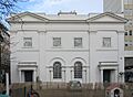
| Brighton and Hove Reform Synagogue (More images) |
_(2).JPG) |
Hove 50°49′47″N 0°09′46″W / 50.8296°N 0.1627°W |
Jewish (Movement for Reform Judaism) | L | Founded in 1967, this synagogue can hold 400 people. The land was donated by Lord Cohen of Brighton. |
| Brighton and Hove Progressive Synagogue (More images) |
 |
Hove 50°49′39″N 0°09′32″W / 50.8276°N 0.1589°W |
Jewish (Liberal Judaism) | – | This synagogue was originally a gymnasium, rebuilt in 1937 and again in 1949. |
| Hove Hebrew Congregation Synagogue (More images) |
_(6).jpg) |
Hove 50°49′41″N 0°09′40″W / 50.8281°N 0.1610°W |
Jewish (Ashkenazi) | L | The Chief Rabbi laid the first stone of this synagogue, built between 1929 and 1930. |
| Al-Madina Mosque (More images) |
 |
Brighton 50°49′26″N 0°09′15″W / 50.8239°N 0.1541°W |
Muslim | – | This is one of two former houses in the city that have been converted into mosques. |
| Al-Quds Mosque (More images) |
 |
Prestonville 50°50′05″N 0°09′03″W / 50.8347°N 0.1508°W |
Muslim | – | A group of Muslims bought this converted house, which used to be a nursery, to create an Islamic center and mosque. |
| Shahjalal Muslim Cultural Centre (More images) |
 |
Aldrington 50°50′02″N 0°11′25″W / 50.8338°N 0.1904°W |
Muslim | – | This building, once used by a friendly society, has been turned into a mosque and Muslim community center. |
| Emmanuel (at Oasis) (More images) |
_(1).JPG) |
Hangleton 50°50′52″N 0°12′04″W / 50.8479°N 0.2010°W |
Non-denominational | – | This church, with a steep roof, opened in 1957. Emmanuel has five locations in Brighton and Hove. |
| Emmanuel (at The Clarendon Centre) (More images) |
 |
New England Quarter 50°49′57″N 0°08′24″W / 50.8324°N 0.1399°W |
Non-denominational | – | This church is in a converted electrical warehouse near Brighton railway station. It has been part of the Emmanuel network since 2011. |
| Emmanuel (at The Villas) (More images) |
 |
Hove 50°49′56″N 0°10′27″W / 50.8321°N 0.1741°W |
Non-denominational | – | This mission chapel was bought by an Evangelical group in 1961. Weekly services started here again in 2013. |
| Bevendean Community Church (More images) |
_(1).jpg) |
Bevendean 50°50′31″N 0°05′39″W / 50.8420°N 0.0941°W |
Salvation Army | – | The Salvation Army has used this church as its base since 1970. |
| Brighton Salvation Army Citadel (More images) |
 |
Round Hill 50°49′57″N 0°08′00″W / 50.8324°N 0.1332°W |
Salvation Army | – | The current octagonal building was built after the old one was torn down in 2000. People helped pay for it by "buying a brick." |
| Hove Salvation Army Citadel (More images) |
.JPG) |
Hove 50°50′09″N 0°10′38″W / 50.8357°N 0.1771°W |
Salvation Army | – | The Salvation Army has been in Hove since 1882. This building was founded in 1890. |
| Rudyard Hall (More images) |
 |
Woodingdean 50°50′08″N 0°03′59″W / 50.8355°N 0.0663°W |
Brethren | – | This building was registered as a Brethren place of worship in 1952. |
| Bodhisattva Mahayna Buddhist Centre (More images) |
,_Lansdowne_Road,_Hove_(NHLE_Code_1206258)_(January_2012)_(1).jpg) |
Hove 50°49′39″N 0°09′23″W / 50.8274°N 0.1565°W |
Buddhist (New Kadampa Tradition) | II | This center is in a former convent from the early 1800s. The chapel was turned into a worship space. |
| Brighton Buddhist Centre (More images) |
_(2).JPG) |
North Laine 50°49′30″N 0°08′24″W / 50.8251°N 0.1400°W |
Buddhist (Triratna Buddhist Community) | – | This center is part of a worldwide Buddhist community founded in 1967. |
| Kingdom Hall (More images) |
.JPG) |
Aldrington 50°50′00″N 0°11′16″W / 50.8333°N 0.1878°W |
Jehovah's Witnesses | – | This building is used by the Hove and Portslade groups of Jehovah's Witnesses. |
| Kingdom Hall (More images) |
_(3).JPG) |
Woodingdean 50°50′05″N 0°05′14″W / 50.8347°N 0.0872°W |
Jehovah's Witnesses | – | This low, brick building was registered for worship in 1994. It's used by three Brighton-based groups. |
| Brighton and Hove National Spiritualist Church (More images) |
Carlton Hill 50°49′20″N 0°07′53″W / 50.8223°N 0.1313°W |
Spiritualist | L | This unique, curvy building from the mid-1960s replaced an older chapel. | |
| Brotherhood Gate Spiritualist Church | Kemptown 50°49′16″N 0°08′03″W / 50.8211°N 0.1342°W |
Spiritualist | – | This church was first registered in 1939 and then re-registered in 1969 with its current name. | |
| Brighton Baháʼí Centre (More images) |
_(2).JPG) |
Preston Park 50°50′19″N 0°08′26″W / 50.8387°N 0.1406°W |
Baháʼí Faith | – | A house was turned into this place of worship for the Baháʼí Faith in 2002. It's used for worship and study. |
| First Church of Christ, Scientist (More images) |
 |
Montpelier 50°49′34″N 0°09′07″W / 50.8261°N 0.1519°W |
Christian Scientist | L | Originally a house, this building was converted into a church in 1921 and has a beautifully carved front. |
| Oxford Street Chapel (More images) |
,_11_Oxford_Street,_Brighton_(September_2019)_(2).jpg) |
Brighton 50°49′52″N 0°08′07″W / 50.8310°N 0.1354°W |
Church of Christ | L | This small, stuccoed chapel was built in 1890 and has been used by a Church of Christ group since the late 1910s. |
| St Mary and St Abraam Church (More images) |
 |
Hove 50°49′52″N 0°09′21″W / 50.8311°N 0.1558°W |
Coptic Orthodox Church | – | This church, originally Anglican, was bought by the Coptic Orthodox Church in 1994. Their leader traveled to Hove for its dedication. |
| Fountain Centre (Immanuel Family Church) (More images) |
,_Braybon_Avenue,_Patcham.JPG) |
Patcham 50°51′32″N 0°08′33″W / 50.8590°N 0.1424°W |
Elim Pentecostal | L | This building, originally an Anglican church from 1958, is now used by an Elim congregation. |
| Church of the Holy Trinity (More images) |
_(August_2019)_(3).jpg) |
Carlton Hill 50°49′26″N 0°07′53″W / 50.8240°N 0.1314°W |
Greek Orthodox | II | This church opened in 1840 as an Anglican church. It was bought by the Greek Orthodox community in 1994. |
| Shree Swaminarayan Mandir (More images) |
 |
Southern Cross 50°50′13″N 0°12′59″W / 50.8369°N 0.2163°W |
Hindu (Swaminarayan Sampradaya) | – | This was the first Hindu temple south of London when it opened in 1999. It used to be a shop and social club. |
| City Coast Church (More images) |
.jpg) |
Portslade 50°49′51″N 0°12′36″W / 50.8309°N 0.2099°W |
International Network of Churches | – | This church moved to its current modern building in Portslade in 1999. |
| Church of Jesus Christ of Latter-day Saints (More images) |
.JPG) |
Hollingdean 50°50′17″N 0°07′28″W / 50.8380°N 0.1245°W |
Latter-day Saint | – | The Brighton group of The Church of Jesus Christ of Latter-day Saints worships at this church. It was registered in 1993. |
| Oratory of St Cuthman and St Wilfrid (More images) |
 |
Round Hill 50°49′56″N 0°08′00″W / 50.8321°N 0.1334°W |
Old Roman Catholic Church in Europe | – | This building, connected to The Salvation Army's hall, is used for Mass by this Roman Catholic group. |
| Brighton Friends Meeting House (More images) |
_(March_2014)_(1).jpg) |
The Lanes 50°49′19″N 0°08′29″W / 50.8219°N 0.1414°W |
Quaker | II | Brighton's Quaker community built this meeting house in 1805. It has been expanded several times. |
| Galeed Strict Baptist Chapel (More images) |
.JPG) |
North Laine 50°49′38″N 0°08′28″W / 50.8273°N 0.1410°W |
Strict Baptist | L | This simple chapel was designed in 1868. It has an inscription that reads "GALEED A.D. 1868." |
| Brighton Unitarian Church (More images) |
 |
Brighton 50°49′26″N 0°08′22″W / 50.8239°N 0.1395°W |
Unitarian | II | This Greek Revival chapel, with a huge front porch, was built in 1820 on land sold by the Prince Regent. |
Former Places of Worship
| Name | Picture | Where it is | Religion | Grade | Cool Facts |
|---|---|---|---|---|---|
| St Andrew's Church (More images) |
_(January_2017)_(2).jpg) |
Brunswick Town 50°49′25″N 0°09′26″W / 50.8235°N 0.1571°W |
Anglican | I | This church closed in 1990 due to low attendance. Its outside was the first example of the Italian style in England. |
| St Peter's Church (More images) |
.jpg) |
Preston Village 50°50′32″N 0°08′58″W / 50.8423°N 0.1495°W |
Anglican | II* | This ancient parish church is mostly from the 13th century. It was fixed up in the 1870s and after a fire in 1906. |
| St Stephen's Church (More images) |
_(August_2017)_(1).JPG) |
Montpelier 50°49′36″N 0°09′11″W / 50.8266°N 0.1531°W |
Anglican | II* | This building was originally a ballroom in 1766, then the Royal Pavilion's chapel. It became a church in 1850 and is now a day center for people experiencing homelessness. |
| Holy Trinity Church (More images) |
,_Ship_Street,_Brighton_(NHLE_Code_1380934)_(May_2013)_(2).jpg) |
The Lanes 50°49′22″N 0°08′31″W / 50.8228°N 0.1420°W |
Anglican | II | This church, built in 1817, was popular with Brighton's high society. It closed in 1984 and is now an art gallery. |
| Holy Trinity Church (More images) |
 |
Hove 50°49′52″N 0°10′19″W / 50.8312°N 0.1719°W |
Anglican | II | This church closed in 2007 due to fewer people attending. It might be torn down. |
| St Augustine's Church (More images) |
_(February_2020)_(8).JPG) |
Preston Park 50°50′18″N 0°08′24″W / 50.8383°N 0.1400°W |
Anglican | II | This red-brick church was started in 1896 and closed in 2002. |
| St Mark's Church (More images) |
_(February_2014)_(1).jpg) |
Kemptown 50°49′03″N 0°06′43″W / 50.8176°N 0.1120°W |
Anglican | II | Built between 1838 and 1849, this church became a school chapel and concert hall in 1986. |
| St Wilfrid's Church (More images) |
.JPG) |
Elm Grove 50°49′54″N 0°07′16″W / 50.8317°N 0.1210°W |
Anglican | II | This church, built in 1932–1934, was called "about the best 1930s church" by one expert. It closed in 1980 and is now housing. |
| Stanmer Church (More images) |
 |
Stanmer 50°52′13″N 0°06′07″W / 50.8703°N 0.1019°W |
Anglican | II | This church, rebuilt in 1838, closed in 2008. It stands in the large Stanmer Park. |
| Beulah Mission Hall (More images) |
Southern Cross 50°50′18″N 0°12′58″W / 50.8384°N 0.2161°W |
Anglican | – | This small mission hall, built around 1905, is now used as a garage. | |
| Bute Mission Hall (More images) |
_(2).JPG) |
Queen's Park 50°49′27″N 0°07′11″W / 50.8243°N 0.1197°W |
Anglican | – | This red-brick building from 1893 now houses a carpet showroom. |
| Church of the Holy Nativity (More images) |
_(6).JPG) |
Bevendean 50°50′35″N 0°05′57″W / 50.8431°N 0.0993°W |
Anglican | – | This church, built in a unique modern style, closed in 2007 and became a community center. |
| St Agnes' Church (More images) |
_(8).jpg) |
Hove 50°50′12″N 0°10′23″W / 50.8368°N 0.1731°W |
Anglican | – | This red-brick and stone church from 1913 was turned into a gymnasium. |
| St Richard of Chichester's Church (More images) |
 |
Hollingdean 50°50′35″N 0°07′36″W / 50.8431°N 0.1268°W |
Anglican | – | This small brick church, built in 1954, closed for worship in 2013. |
| Bristol Road Methodist Church (More images) |
.jpg) |
Kemptown 50°49′11″N 0°07′28″W / 50.8196°N 0.1245°W |
Methodist | II | This church, built in 1873, closed in 1989 and became a recording studio. |
| Goldstone Villas Methodist Church (More images) |
 |
Hove 50°49′57″N 0°10′20″W / 50.8324°N 0.1723°W |
Methodist | L | This church closed in 1933 and was converted into offices in 1968. |
| Queen's Park Methodist Church (More images) |
,_Queen%27s_Park_Road,_Brighton_(August_2019)_(2).JPG) |
Queen's Park 50°49′33″N 0°07′38″W / 50.8257°N 0.1272°W |
Methodist | L | This church opened in 1891 and held its last service in 1987. It's now a nursery school. |
| United Methodist Church (More images) |
 |
Hove 50°50′03″N 0°09′17″W / 50.8342°N 0.1547°W |
Methodist | L | This church, built in 1904, closed in 1947 and was sold to a foundation for people with learning disabilities. |
| Franklin Road Methodist Church (More images) |
 |
Portslade 50°50′00″N 0°12′30″W / 50.8334°N 0.2084°W |
Methodist | – | This church was built in 1907, closed in 1964, and is now used for businesses. |
| Gordon Mission Hall (More images) |
 |
Kemptown 50°49′18″N 0°07′56″W / 50.8217°N 0.1321°W |
Methodist | – | This chapel, built in 1886, has been used by three different religious groups but is now a home. |
| Hollingbury Methodist Church (More images) |
,_Lyminster_Avenue,_Hollingbury.JPG) |
Hollingbury 50°51′35″N 0°07′58″W / 50.8597°N 0.1327°W |
Methodist | – | This small brick building opened in 1952. It closed in 2010 and is now a nursery school. |
| London Road Methodist Church (More images) |
_(1).jpg) |
Brighton 50°49′57″N 0°08′14″W / 50.8325°N 0.1372°W |
Methodist | – | This building from 1894 was used for worship until 2006. It later housed a theater and café. |
| Clarence Baptist Chapel | .jpg) |
Brighton 50°49′25″N 0°08′55″W / 50.8236°N 0.1487°W |
Baptist | – | This chapel from 1833 is now known as Brighton Little Theatre. |
| Islingword Road Baptist Mission |  |
Hanover 50°49′52″N 0°07′39″W / 50.8310°N 0.1275°W |
Baptist | – | This small chapel from 1881 is now two houses. |
| Jireh Strict Baptist Chapel |  |
North Laine 50°49′35″N 0°08′16″W / 50.8263°N 0.1377°W |
Baptist | – | This chapel originally had two floors, but a third was added after it stopped being used for religious purposes around 1902. |
| Queen Square Baptist Chapel |  |
Brighton 50°49′29″N 0°08′37″W / 50.8246°N 0.1437°W |
Baptist | – | This chapel was used by Baptists from 1856 to 1908. Since then, it's been used for businesses. |
| Sudeley Place Congregational Chapel (More images) |
_(3).JPG) |
Kemptown 50°49′04″N 0°07′02″W / 50.8179°N 0.1171°W |
Congregational | L | This church from 1891 was used until about 1918, then became a cinema, and is now homes. |
| Trinity Independent Congregational Chapel (More images) |
 |
North Laine 50°49′27″N 0°08′18″W / 50.8241°N 0.1383°W |
Congregational | L | This church from the 1820s closed around 1896. It has been Brighton's music library and an arts venue. |
| Belgrave Street Congregational Church (More images) |
.JPG) |
Hanover 50°49′44″N 0°07′49″W / 50.8289°N 0.1304°W |
Congregational | – | This chapel was used from 1865 to 1939. It later became part of Brighton Technical College. |
| Rottingdean Congregational Chapel (More images) |
.JPG) |
Rottingdean 50°48′15″N 0°03′29″W / 50.8042°N 0.0581°W |
Congregational | – | This small chapel, built in the 1890s, closed in the 1980s and is now a shop. |
| Roof-top synagogue | .jpg) |
Brunswick Town 50°49′25″N 0°09′39″W / 50.8236°N 0.1607°W |
Jewish (Orthodox) (breakaway) | I | This was a private synagogue built on the roof of Philip Salomons' home. It's now part of a private apartment. |
| Middle Street Synagogue (More images) |
 |
The Lanes 50°49′16″N 0°08′34″W / 50.8211°N 0.1428°W |
Jewish (Orthodox) | II* | This synagogue from 1874 has a very fancy interior. It closed in 2004 because of high costs and other synagogues in the city. |
| Brighton Regency Synagogue (More images) |
 |
Kemptown 50°49′17″N 0°07′51″W / 50.8213°N 0.1309°W |
Jewish (Orthodox) | II | Brighton's first synagogue was built here in 1826. After a new synagogue opened, it was sold and is now a home. |
| Union Chapel (More images) |
,_Union_Street,_Brighton.jpg) |
The Lanes 50°49′20″N 0°08′28″W / 50.8223°N 0.1410°W |
Elim Pentecostal | II | Brighton's first Nonconformist place of worship opened here in the late 1600s. It's now a pub. |
| Elim Community Church (More images) |
,_209_Portland_Road,_Aldrington_(March_2020)_(1).JPG) |
Aldrington 50°50′03″N 0°11′31″W / 50.8343°N 0.1919°W |
Elim Pentecostal | – | This small chapel from 1929 became a nursery school after the church group moved out in 1994. |
| Clermont Church (More images) |
,_Clermont_Terrace,_Preston_Village,_Brighton.jpg) |
Preston Village 50°50′39″N 0°09′14″W / 50.8442°N 0.1539°W |
United Reformed Church | L | This chapel, built in 1877–78, is being converted into six flats, but its outside will stay the same. |
| Lewes Road United Reformed Church (More images) |
,_Lewes_Road,_Brighton_(January_2014).jpg) |
Brighton 50°50′09″N 0°07′33″W / 50.8359°N 0.1257°W |
United Reformed Church | – | This building from 1878 is now 31 apartments for people who used to be homeless. Its original front has been kept. |
| Emmanuel Full Gospel Church (More images) |
.JPG) |
Elm Grove 50°49′55″N 0°07′33″W / 50.8320°N 0.1258°W |
Assemblies of God | – | This small chapel has been in Hanover since 1932. |
| Mile Oak Gospel Hall (More images) |
 |
Mile Oak 50°51′04″N 0°13′41″W / 50.8510°N 0.2280°W |
Churches of God | – | This church opened in 1966. It was sold in the 2010s and became a wellness center. |
| City Gate Church |  |
Brighton 50°49′58″N 0°08′15″W / 50.8327°N 0.1376°W |
Evangelical | – | This Evangelical group used a converted building on London Road for worship between 1994 and 2014. |
| Bentham Road Mission Hall (More images) |
_(1).JPG) |
Hanover 50°49′49″N 0°07′23″W / 50.8302°N 0.1231°W |
Free Church | – | This small hall, built in 1881, is now boarded up and empty. |
| Kingdom Hall (More images) |
_(2).JPG) |
Seven Dials 50°49′47″N 0°09′08″W / 50.8297°N 0.1522°W |
Jehovah's Witnesses | – | This Kingdom Hall was in a converted building and closed down. |
| Church of Jesus Christ of Latter Day Saints (More images) |
 |
Coldean 50°51′28″N 0°06′27″W / 50.8577°N 0.1075°W |
Latter-Day Saint | – | This church in Coldean closed in 1993 when a new building opened. It might be torn down. |
| Park Road Hall |  |
Rottingdean 50°48′14″N 0°03′30″W / 50.8039°N 0.0582°W |
Non-denominational | L | This locally listed building is now used as a Montessori school and for community events. |
| Goldstone Valley Gospel Hall (More images) |
 |
West Blatchington 50°50′56″N 0°10′52″W / 50.8489°N 0.1810°W |
Open Brethren | – | This Gospel hall was sold in 2020 and is no longer used for religious purposes. |
| L'Eglise Française Reformée (More images) |
 |
Brighton 50°49′19″N 0°08′58″W / 50.8220°N 0.1495°W |
Reformed Church of France | L | The only French Protestant church in Britain outside London. It closed in 2008 due to fewer French-speaking worshippers. |
| Salvation Army Citadel (More images) |
.jpg) |
Portslade 50°49′52″N 0°12′49″W / 50.8311°N 0.2135°W |
Salvation Army | – | This building was used as a citadel from 1910 to 1966, then sold for business use. |
| Seventh Day Adventist Church (More images) |
_(1).JPG) |
Hove 50°49′32″N 0°10′29″W / 50.8256°N 0.1748°W |
Seventh-day Adventist | – | This tiny brick cottage was originally a coach house before being used as a church. |
| Dependants' Chapel (More images) |
.JPG) |
Aldrington 50°50′10″N 0°11′14″W / 50.8361°N 0.1872°W |
Society of Dependants | – | This chapel, built in 1905, was turned into a house in the late 1970s. |
| Chapel of the Holy Family (More images) |
,_Hollingdean.jpg) |
Hollingdean 50°50′33″N 0°07′49″W / 50.8425°N 0.1302°W |
Roman Catholic (Society of St. Pius X) | – | This chapel belongs to a Traditionalist Catholic group and holds services a few times a month. |
| Brighton and Hove Central Spiritualist Church |  |
Montpelier 50°49′33″N 0°09′18″W / 50.8258°N 0.1549°W |
Spiritualist | – | This church was registered in 1984. The group joined another Spiritualist church in 2019. |
Images for kids
-
Former Hanover Chapel
-
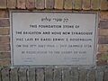
Plaque at Brighton and Hove Reform Synagogue
_(2).jpg)

