
Niagara County, New York facts for kids
Quick facts for kids
Niagara County
|
|||
|---|---|---|---|

Niagara County Clerks Office
|
|||
|
|||

Location within the U.S. state of New York
|
|||
 New York's location within the U.S. |
|||
| Country | |||
| State | |||
| Founded | March 11, 1808 | ||
| Seat | Lockport | ||
| Largest city | Niagara Falls | ||
| Area | |||
| • Total | 1,140 sq mi (3,000 km2) | ||
| • Land | 522 sq mi (1,350 km2) | ||
| • Water | 617 sq mi (1,600 km2) 54% | ||
| Population
(2020)
|
|||
| • Total | 212,666 | ||
| • Density | 407.1/sq mi (157.2/km2) | ||
| Time zone | UTC−5 (Eastern) | ||
| • Summer (DST) | UTC−4 (EDT) | ||
| Congressional districts | 24th, 26th | ||


Niagara County is a county located in the western part of New York, a state in the United States. In 2020, about 212,666 people lived here. The main town where the county government is located is Lockport.
The name "Niagara" comes from an Iroquois word, Onguiaahra. This word means "the strait" or "thunder of waters," which makes sense because of the famous Niagara Falls located here. Niagara County is part of the larger Western New York area.
This county is also part of the Buffalo–Niagara Falls metropolitan area. It shares a border with Canada, specifically the province of Ontario. Besides Niagara Falls, the county is home to Fort Niagara and many fun parks and lakeside communities. In 2008, Niagara County celebrated its 200th birthday!
Contents
History of Niagara County
How Niagara County Was Formed
When counties were first set up in the New York colony in 1683, the land that is now Niagara County was part of a huge area called Albany County. Before the British arrived, this area was part of New Netherland, a Dutch colony.
Albany County was enormous. It covered the northern part of New York State and even included all of what is now Vermont. It was thought to stretch all the way to the Pacific Ocean! Over time, this huge county was made smaller.
In 1772, Albany County was split into three parts. One new part was called Tryon County. This county covered the western areas, including where Niagara County is today. Tryon County was named after William Tryon, who was the governor of New York at the time.
Changes After the American Revolution
After the American Revolutionary War, many people who supported the British in Tryon County moved to Canada. In 1784, the name of Tryon County was changed. It was renamed Montgomery County to honor General Richard Montgomery. He was a hero who fought in the war and died trying to capture the city of Quebec.
Later, in 1789, Ontario County was created from Montgomery County. Then, in 1802, Genesee County was formed from Ontario County.
Finally, in 1808, Niagara County was officially created from Genesee County. At first, it was even bigger than it is today. In 1821, Erie County was created from a part of Niagara County, giving Niagara County its current size.
Many historical places in Niagara County are listed on the National Register of Historic Places.
Geography and Natural Features
What is Niagara County Like?
Niagara County covers about 1,139 square miles. A little over half of this area (about 617 square miles) is water, and the rest (about 522 square miles) is land.
The county is located in the very western part of New York State. It is just north of the city of Buffalo. To its north, it borders Lake Ontario, and to its west, the Niagara River forms the border with Canada.
The Famous Niagara Falls
The most important natural feature in Niagara County is Niagara Falls. Over the past 12,000 years, since the last ice age, the riverbed has slowly moved seven miles south. The Niagara River and Niagara Falls are like a giant drain for four of the Great Lakes. These lakes hold the world's largest supply of fresh water.
The water flows north from Lake Erie, then through the Niagara River, over Niagara Falls, and finally into Lake Ontario. From there, it goes into the St. Lawrence River and eventually reaches the North Atlantic Ocean. Today, visitors see less water flowing over the Falls. This is because some of the water is used to create hydroelectric power at large power plants on both the American and Canadian sides of the river.
Niagara Gorge and Farming Land
The Niagara Gorge is the path the Falls have carved out over thousands of years as they slowly erode the land. Niagara Falls originally started at the Niagara Escarpment. This is a long ridge of rock that cuts Niagara County in half from east to west.
North of the Escarpment is a flat, fertile area called the Lake Plain. This land is great for growing fruits and vegetables like grapes, apples, and peaches. The Niagara grape, which is used for most American white grape juice, was first grown here in 1868. Recently, more wine-making has started in the area, with several wineries opening below the escarpment. This has helped the local economy.
Neighboring Areas
Niagara County shares borders with:
- Orleans County to the east
- Genesee County to the southeast
- Erie County to the south
- The Niagara Region in Ontario, Canada, to the west
Major Roads in Niagara County
Here are some of the main highways that run through Niagara County:
 Interstate 190 (Niagara Thruway)
 U.S. Route 62
US 62 Business New York State Route 18
 New York State Route 31
 New York State Route 78
 New York State Route 93
 New York State Route 104
 New York State Route 265
 New York State Route 384
 New York State Route 425
 Niagara Scenic Parkway
 LaSalle Expressway
State Parks and Protected Areas
Niagara County has many beautiful state parks and protected areas, including:
- De Veaux Woods State Park
- Devil's Hole State Park
- Fort Niagara State Park
- Earl W. Brydges Artpark State Park
- Four Mile Creek State Park
- Golden Hill State Park
- Hartland Swamp Wildlife Management Area
- Joseph Davis State Park
- Niagara Reservation State Park
- Reservoir State Park
- Tonawanda Wildlife Management Area
- Wilson-Tuscarora State Park
Population and People
How Many People Live Here?
| Historical population | |||
|---|---|---|---|
| Census | Pop. | %± | |
| 1810 | 8,971 | — | |
| 1820 | 22,990 | 156.3% | |
| 1830 | 18,482 | −19.6% | |
| 1840 | 31,132 | 68.4% | |
| 1850 | 42,276 | 35.8% | |
| 1860 | 50,399 | 19.2% | |
| 1870 | 50,437 | 0.1% | |
| 1880 | 54,173 | 7.4% | |
| 1890 | 62,491 | 15.4% | |
| 1900 | 74,961 | 20.0% | |
| 1910 | 92,036 | 22.8% | |
| 1920 | 118,705 | 29.0% | |
| 1930 | 149,329 | 25.8% | |
| 1940 | 160,110 | 7.2% | |
| 1950 | 189,992 | 18.7% | |
| 1960 | 242,269 | 27.5% | |
| 1970 | 235,720 | −2.7% | |
| 1980 | 227,354 | −3.5% | |
| 1990 | 220,756 | −2.9% | |
| 2000 | 219,846 | −0.4% | |
| 2010 | 216,469 | −1.5% | |
| 2020 | 212,666 | −1.8% | |
| U.S. Decennial Census 1790-1960 1900-1990 1990-2000 2010-2019 |
|||
In 2010, there were 216,469 people living in Niagara County. There were about 87,846 households, which are groups of people living together. The average household had about 2.45 people.
The population was spread out by age. About 24.7% of people were under 18 years old. About 15.4% were 65 years or older. The average age of people in the county was 38 years old.
Most people in Niagara County speak English. Some other languages spoken include Spanish and Italian.
What About the 2020 Census?
| Race | Num. | Perc. |
|---|---|---|
| White (NH) | 173,691 | 82.0% |
| Black or African American (NH) | 16,206 | 7.62% |
| Native American (NH) | 2,294 | 1.1% |
| Asian (NH) | 2,439 | 1.2% |
| Pacific Islander (NH) | 45 | 0.02% |
| Other/Mixed (NH) | 10,173 | 5.0% |
| Hispanic or Latino | 7,818 | 4.0% |
The 2020 census showed that the population was 212,666. The table above shows the different racial groups living in Niagara County.
Education in Niagara County
Colleges and Universities
Niagara University is a college located in Lewiston. Niagara County Community College is another college, found in Sanborn. Many students from Niagara County also attend colleges in Erie County and other nearby areas.
The Buffalo metropolitan area, which includes Niagara County, has over 20 public and private colleges. These schools offer many different programs, from technical training to advanced studies.
Local School Districts
Here are the public school districts that serve students from kindergarten through 12th grade in Niagara County:
- Barker Central School District
- Lewiston-Porter Central School District
- Lockport City School District
- Newfane Central School District
- Niagara Falls City School District
- Niagara-Wheatfield Central School District
- North Tonawanda City School District
- Royalton-Hartland Central School District
- Starpoint Central School District
- Wilson Central School District
Communities in Niagara County
Major Towns and Cities

Here are some of the largest communities in Niagara County, listed by population:
| # | Location | Population | Type | Area |
|---|---|---|---|---|
| 1 | Niagara Falls | 50,193 | City | Greater Niagara |
| 2 | North Tonawanda | 31,568 | City | Greater Niagara |
| 3 | Lockport | 21,165 | City | Southeast |
| 4 | South Lockport | 8,234 | CDP | Southeast |
| 5 | Newfane | 3,822 | CDP | Lake Shore |
| 6 | Lewiston | 2,701 | Village | Greater Niagara |
| 7 | Youngstown | 1,935 | Village | Greater Niagara |
| 8 | Middleport | 1,840 | Village | Southeast |
| 9 | Sanborn | 1,645 | CDP | Greater Niagara |
| 10 | Rapids | 1,636 | CDP | Southeast |
| 11 | Ransomville | 1,419 | CDP | Lake Shore |
| 12 | Wilson | 1,264 | Village | Lake Shore |
| 13 | Gasport | 1,248 | CDP/Hamlet | Southeast |
| 14 | Olcott | 1,241 | CDP | Lake Shore |
| 15 | Barker | 533 | Village | Lake Shore |
Towns in Niagara County
Niagara County is divided into several towns:
Smaller Communities (Hamlets and CDPs)

Some smaller communities are called hamlets or Census Designated Places (CDPs). These include:
- Nashville
- Orangeport
- Pekin
- Newfane
- Niagara University
- Olcott
- Ransomville
- Rapids
- Sanborn
- South Lockport
Indian Reservations
Niagara County is also home to two Native American reservations:
Images for kids
-
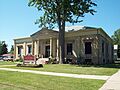
Niagara County Clerks Office
-
Seal of Niagara County, New York
-
Flag of Niagara County, New York
See also
 In Spanish: Condado de Niágara para niños
