Santa Clara River (California) facts for kids
Quick facts for kids Santa Clara River |
|
|---|---|
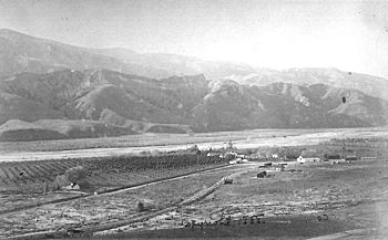
View of Santa Clara River with Rancho Camulos in the foreground, 1888
|
|
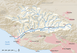
Map of the Santa Clara River watershed
|
|
|
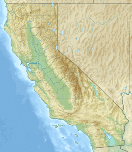
Location of the mouth of the Santa Clara River in California
|
|
| Native name | Spanish: Río Santa Clara |
| Other name(s) | Rio de Santa Clara |
| Country | United States |
| State | California |
| Counties | Los Angeles, Ventura |
| Physical characteristics | |
| Main source | San Gabriel Mountains Aliso Canyon, Angeles National Forest, Los Angeles County 5,800 ft (1,800 m) 34°26′01″N 118°21′51″W / 34.43361°N 118.36417°W |
| River mouth | Pacific Ocean Between Ventura and Oxnard, Ventura County 0 ft (0 m) 34°14′07″N 119°15′49″W / 34.23528°N 119.26361°W |
| Length | 83 mi (134 km) |
| Basin features | |
| Basin size | 1,600 sq mi (4,100 km2) |
| Tributaries | |
The Santa Clara River (also known as Spanish: Río Santa Clara) is a long river in Southern California, stretching about 83 miles (134 km). It's one of the most active river systems in the region. The river collects water from four mountain ranges north and northwest of Los Angeles. Then, it flows west across the Oxnard Plain and into the Santa Barbara Channel of the Pacific Ocean.
This river area has been home to many native plants and animals for a long time. It has also provided water, fish, and rich farmland for people. The northern part of the river's basin was home to the Tataviam people, while the southern part was used by the Chumash people. A large part of the Santa Clara River Valley is used for farming. This has helped keep the river's natural flood areas mostly free from man-made walls (levees). Even though it's one of the most natural rivers in Southern California, some levees do exist where the river flows through cities.
Contents
History of the Santa Clara River
The Santa Clara River was first named "Rio de Santa Clara" on August 9, 1769. This was done by the Portolá expedition as they traveled north from San Diego. They named it to honor Saint Clare of Assisi, who passed away on August 11, 1253. The valley around the river was then known as the "Cañada de Santa Clara."
The Santa Clara-Mojave River Ranger District, which is part of the Angeles National Forest, is named after this river.
Major Floods and the St. Francis Dam
A very large flood happened when the St. Francis Dam broke almost completely. This happened in the middle of the night on March 12, 1928. The dam was holding a huge amount of water, about 12.4 billion gallons (47 billion liters). This water rushed down San Francisquito Canyon and into the Santa Clara River.
Where the Santa Clara River Flows
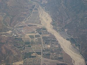
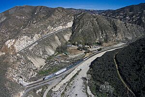
The Santa Clara River starts in the northern parts of the San Gabriel Mountains. This area is inside the western part of the Angeles National Forest. Its biggest starting branch, Aliso Canyon, is about 7 miles (11 km) long. These branches come together to form the main river near the town of Acton. The river then flows west through Soledad Canyon, passing under California State Route 14 near Canyon Country.
The Sierra Pelona Mountains to the north also add water to the river, especially from seasonal streams. The river then receives water from Bouquet Creek, Placerita Creek, and San Francisquito Creek within the City of Santa Clarita. Here, the riverbed is usually dry for most of the year. It only has flowing water during very heavy rains. The river then goes west under Interstate 5 and gets more water from Castaic Creek.
After Castaic Creek joins, the river mostly flows southwest through the Santa Clarita Valley. Near the border between Los Angeles County and Ventura County, the river enters the Santa Clara River Valley. It flows past Buckhorn and Fillmore. Here, it gets more water from Piru Creek and Sespe Creek. It also receives Santa Paula Creek at the town of Santa Paula. The river then bends southwest, passing the Saticoy Oil Field.
The Santa Clara River finally reaches the Pacific Ocean. It flows across the northern part of the Oxnard Plain, making the land fertile with the mud it carries. A sand bar usually blocks the river's mouth. This area is called the Santa Clara Estuary Natural Preserve, located within McGrath State Beach in Oxnard.
Santa Clara River Watershed
The Santa Clara River watershed covers about 1,600 square miles (4,100 km²). Even though it's close to the busy Los Angeles Basin, it remains one of the most natural areas on the South Coast. Mountains surround it: the Santa Susana Mountains to the south, the San Gabriel Mountains to the east, and the Santa Ynez Mountains, Sespe Mountains, San Cayetano Mountains, and Tehachapi Mountains to the north.
Piru Creek, Castaic Creek, and Sespe Creek are the main streams that flow into the Santa Clara River. Each of these is over 50 miles (80 km) long. Piru and Castaic Creeks have reservoirs that store water for the California State Water Project. These include Pyramid Lake and Lake Piru on Piru Creek, and Elderberry Forebay and Castaic Lake on Castaic Creek. Interestingly, Sespe Creek is a special "National Wild and Scenic River". This is rare for streams in Southern California.
The Santa Clara River watershed is next to other river areas. To the west is the Ventura River watershed. To the northwest is the Santa Ynez River watershed. To the north is the Tulare Lake basin in the Central Valley. To the east is the Mojave River, and to the south is the Los Angeles River. The Santa Clara River is the second largest river in Southern California, after the Santa Ana River.
The River's Mouth (Estuary)
The area where the river meets the ocean, called the estuary, has been changed by people since at least 1855. By the late 1920s, roads and farms were built there. In the late 1950s, a water treatment plant and more farms were built. Walls (levees) were put in place to keep the river from flooding these areas. McGrath State Beach was created in 1948. The estuary is now a Natural Preserve within McGrath State Beach.
The city of Ventura releases about 9 million gallons (34 million liters) of treated water into the estuary every day. A sand berm (a natural sand barrier) usually separates the river from the ocean for most of the year. When there's enough rain, the river breaks through this sand berm. Then, the ocean slowly rebuilds it over the rest of the year. If there's a very dry year, the berm acts like a dam, causing the water level to rise. Sometimes, when the berm breaks when it's not raining, fish can get stuck as the water quickly drains out.
The estuary has had problems with water quality. In 2012, officials required cities and counties along the river to limit the amount of harmful bacteria flowing into the river from stormwater drains. This is especially important during the dry season. Sources of bacteria include pet waste, sewage leaks, and leaves. To improve water quality, cities are sweeping streets more often, cleaning storm drains, fixing sewage leaks, and teaching the public about water safety.
Wildlife and Nature
The Santa Clara River is home to several special animals. These include the unarmored three-spined stickleback fish, steelhead trout, southwestern pond turtle, and least Bell's vireo bird. In 2002, eight Southwest willow flycatcher birds hatched at the Hedrick Ranch Nature Area. This is a 220-acre (89 ha) nature preserve near Santa Paula. The endemic (meaning it's only found here) and endangered Santa Ana sucker fish also lives in parts of the Santa Clara River system.
Steelhead Trout Life Cycle
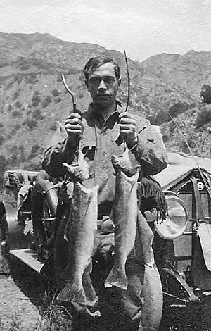
Historically, many steelhead trout used to live and reproduce in the Santa Clara River. Before 1940, thousands of steelhead would swim up the river. This was one of the biggest steelhead populations in Southern California. However, dams and other barriers built in the mid-1900s stopped the steelhead from migrating. This reduced the places they could live and reproduce.
Adult steelhead still try to swim up the river. Wild rainbow trout still live in the upper parts of Santa Paula, Sespe, Hopper, and Piru Creeks. These trout produce young steelhead that try to swim to the Pacific Ocean. But it's hard for them to get to the ocean because of low water levels or predators in the estuary. Invasive plants like Arundo donax also make it harder for trout to reproduce. Genetic tests show that the steelhead in this river are native, not from fish farms.
Other Animals of the River
Beavers (Castor canadensis) used to live in the Santa Clara River before Europeans arrived. This is known from stories told by the Ventureño people. One story mentions beavers building homes in the river near Ventura and Saticoy. A beaver skull found in 1906 in the Sespe Creek tributary also supports this.
Pronghorn antelope (Antilocapra americana) also used to live along the Santa Clara River. In February 1776, Father Pedro Font wrote in his diary that he saw "a very large drove of antelopes which, as soon as they saw us, fled like the wind." The Ventureño people even had a special word for antelope, different from their words for deer and elk.
In 2013, Quagga mussels were found in Lake Piru. These are invasive species that can cause problems in rivers and lakes.
Changes to the River
Changes in Ventura County
The Harbor Boulevard bridge is the most western crossing over the river. Upstream from here, the river banks were used as dumps for many years. This was done to create levees (walls) to stop the river from flooding nearby lands during heavy rains. Three dump sites upstream from the river's mouth were managed by the Ventura Regional Sanitation District.
The riverbed was also dug up a lot for sand and gravel. This happened especially after World War II when many homes and highways were being built. Digging up the riverbed harms the natural areas along the river and changes how mud and sand flow. This mining decreased in the 1990s because of environmental concerns and worries that it was weakening bridge foundations. As of 2010, there were still three active gravel operations upstream.
There are also places where water is taken from the river. The most important is the Freeman Diversion Dam, about 10.7 miles (17.2 km) from the ocean. This dam helps to refill underground water supplies (aquifers) and provides water to the Oxnard Plain. The Vern Freeman Diversion Dam, built in 1991, sends water to shallow basins to help replenish the aquifer. Before this dam, temporary dirt dams were built to divert water for farmers and to refill the aquifer.
The Southern California Steelhead were declared endangered in 1997. The fish ladder on the dam, which helps fish swim past it, was not good enough. In 2015, it was decided that fixing this was very important because it's the first barrier steelhead face when migrating from the ocean. In 2018, a judge ruled that the dam was violating the Endangered Species Act by not providing enough water and a clear path for steelhead.
Changes in Los Angeles County
Newhall Ranch is a very large new community being built in Los Angeles County along the river. This project will change more than 82 acres (33 ha) of flood plain and smaller streams. This area is home to threatened and endangered animals and plants. These include the California condor, California gnatcatcher, southwestern willow flycatcher, least Bell's vireo, arroyo toad, San Fernando Valley spineflower, and threespine stickleback. A water treatment plant for this new community will release treated water into the river as it flows towards the ocean and into Ventura County.
The Newhall Ranch project has faced legal challenges and environmental concerns for many years. Officials and citizens from Ventura County also opposed the project because of its possible effects downstream. However, a court ruling in 2014 found that the project's environmental report was good enough. It said the project would not harm endangered animals, plants, or Native American artifacts. The court also agreed that stormwater runoff from the project would not harm young steelhead trout downstream in Ventura County. Later, the California Supreme Court agreed to review a part of the ruling that might affect protections for other endangered species like the California Condor.
Protecting and Restoring the River
There is a lot of interest in protecting and restoring the natural areas along the Santa Clara River. Many groups are working to keep these areas safe. They help ensure that traditional farming can continue while also protecting the land from new buildings. This allows the river's natural processes, like flooding, to happen in open spaces and farmlands. This helps avoid building more levees, which can increase flood risks further downstream.
One big problem is the giant reed, also known as arundo. This is an invasive species that uses a lot of water. It doesn't provide food for native animals and stops native plants from growing. Efforts are being made to remove this plant.
See also
 In Spanish: Río Santa Clara (California) para niños
 | Stephanie Wilson |
 | Charles Bolden |
 | Ronald McNair |
 | Frederick D. Gregory |


