
Slovakia facts for kids
Quick facts for kids
Slovak Republic
Slovenská republika (Slovak)
|
|
|---|---|
|
National seal
 |
|
.svg) Show globe Show globe Show map of Europe Show map of EuropeLocation of Slovakia (dark green)
– on the European continent (green & dark grey) |
|
| Capital and largest city
|
Bratislava 48°09′N 17°07′E / 48.150°N 17.117°E |
| Official languages | Slovak |
| Ethnic groups
(2021)
|
|
| Religion
(2021)
|
|
| Demonym(s) | Slovak |
| Government | Unitary parliamentary republic |
| Peter Pellegrini | |
| Robert Fico | |
|
• Speaker of the National Council
|
Peter Žiga |
| Legislature | National Council |
| Establishment history | |
| 28 October 1918 | |
|
• Second Czechoslovak Republic
|
30 September 1938 |
|
• Autonomous Land of Slovakia (within Second Czechoslovak Republic)
|
23 November 1938 |
|
• First Slovak Republic
|
14 March 1939 |
| 24 October 1945 | |
|
• Fourth Czechoslovak Republic
|
25 February 1948 |
|
• Czechoslovak Socialist Republic
|
11 July 1960 |
|
• Slovak Socialist Republic (within Czechoslovak Socialist Republic, change of unitary Czechoslovak state into a federation)
|
1 January 1969 |
|
• Slovak Republic (change of name within established Czech and Slovak Federative Republic)
|
1 March 1990 |
|
• Dissolution of
Czechoslovakia |
1 January 1993 |
| Area | |
|
• Total
|
49,035 km2 (18,933 sq mi) (127th) |
|
• Water (%)
|
0.72 (2015) |
| Population | |
|
• 30 June 2024 estimate
|
|
|
• 2021 census
|
|
|
• Density
|
110/km2 (284.9/sq mi) (103rd) |
| GDP (PPP) | 2024 estimate |
|
• Total
|
|
|
• Per capita
|
|
| GDP (nominal) | 2024 estimate |
|
• Total
|
|
|
• Per capita
|
|
| Gini (2022) | ▼ 21.2 low |
| HDI (2022) | very high · 45th |
| Currency | Euro (€) (EUR) |
| Time zone | UTC+1 (CET) |
|
• Summer (DST)
|
UTC+2 (CEST) |
| Date format | d. m. yyyy |
| Driving side | right |
| Calling code | +421 |
| ISO 3166 code | SK |
| Internet TLD | .sk and .eu |


Slovakia, officially called the Slovak Republic (Slovenská republika in Slovak), is a country in Central Europe. It does not have a coastline. Slovakia shares borders with Austria to the southwest, Hungary to the south, Ukraine to the east, Poland to the north, and the Czech Republic to the northwest.
Its capital city is Bratislava. Bratislava is special because it's the only capital city in the world that borders two other countries! Other important cities include Košice, Banská Bystrica, Žilina, Trenčín, Nitra, Prešov, Bardejov, and Trnava. Slovakia joined the European Union in 2004, and its official money is the Euro.
Contents
A Brief History of Slovakia

Long, long ago, around 450 BC, a group of people called the Celts started living in the area that is now Slovakia. They even made coins called Biatec, which were the first signs of writing here. Later, different Germanic tribes moved into the area. The Roman Empire also set up small forts along the Danube river. They even fought battles as far north as Trenčín.
From Great Moravia to the Kingdom of Hungary
In the early 900s, a powerful state called Great Moravia existed. But then, a group called the Magyars arrived from Asia. They defeated Great Moravia in 906. This led to the creation of the Kingdom of Hungary around the year 1000. Slovak people mostly lived in the northern parts of this new kingdom.
In 1241, Mongols invaded, causing many people to be lost. Hungarian kings then invited new settlers, like Germans and Vlachs, to help rebuild the population.
Ottoman Empire and Habsburg Rule
In the 1500s, the Ottoman Empire expanded from the south. They took over important cities in Hungary. Because of this, the capital of the Kingdom of Hungary moved to Bratislava (then called Pressburg or Pozsony). There were many battles against the Ottomans and uprisings against the Habsburg rulers. Bratislava remained the capital until 1848.
Later, the dual monarchy of Austria-Hungary was formed. During this time, until 1918, the Hungarian government tried to limit the Slovak language and culture.
Modern Slovakia: Independence and Division
From 1918 to 1992, Slovakia was part of Czechoslovakia. This country became independent from the Austro-Hungarian Empire in 1918. The first president of Czechoslovakia was Tomáš Garrigue Masaryk.
Czechoslovakia split for the first time in 1938-1939. Slovakia became independent with help from Adolf Hitler. However, it was like a puppet state of Nazi Germany until World War II ended in 1945.
Czechoslovakia was formed again in 1945. Communists took control in 1948 and ruled until 1989. This was when a series of peaceful protests, known as the Velvet Revolution, ended their rule.
Finally, on January 1, 1993, Czechoslovakia peacefully split into two separate countries: Slovakia and the Czech Republic. This event is known as the Velvet Divorce. Slovakia has been a member of the European Union since May 1, 2004.
Geography and Nature

Slovakia is mostly a mountainous country. The Carpathian Mountains stretch across the northern half. These mountains include the Tatra Mountains, Greater Fatra, Lesser Fatra, Slovak Ore Mountains, and Beskids. The largest flat areas are the fertile Danubian Lowland in the southwest and the Eastern Slovak Lowland in the southeast. Forests cover about 41% of Slovakia's land.

The Tatra Mountains
The Tatra Mountains are the highest part of the Carpathian Mountains. They have 29 peaks that are over 2,500 meters (8,200 feet) high. Most of the Tatras are in Slovakia.
The High Tatras are near the Polish border. They are popular for hiking and skiing. They have many beautiful lakes and valleys. The highest point in Slovakia, Gerlachovský štít, is here at 2,655 meters (8,711 feet). The symbolic mountain Kriváň is also in this area.
The Western Tatras have their highest peak, Bystrá, at 2,248 meters (7,375 feet). To the east are the smaller Belianske Tatras.
The Low Tatras are separated from the main Tatras by the Váh river valley. Their highest peak is Ďumbier at 2,043 meters (6,703 feet). The Tatra mountain range is so important that it's shown on the coat of arms of Slovakia.
National Parks and Caves

Slovakia has 9 national parks. These parks protect about 6.5% of the country's land.

There are hundreds of caves under Slovakia's mountains. About 30 of them are open for visitors. Most caves have amazing stalagmites (growing from the ground) and stalactites (hanging from the ceiling). Five Slovak caves are even listed as UNESCO World Heritage Sites. These include Dobšinská Ice Cave, Domica, Gombasek Cave, Jasovská Cave, and Ochtinská Aragonite Cave.
Rivers of Slovakia
.jpg)
Most of Slovakia's rivers start in its mountains. Some rivers only flow through Slovakia, while others form natural borders with neighboring countries. For example, the Dunajec river is in the north, the Danube river in the south, and the Morava river in the west. The total length of rivers in Slovakia is over 49,000 kilometers (30,000 miles)!
The longest river completely within Slovakia is the Váh, which is 403 kilometers (250 miles) long. The shortest is the Čierna voda. Other important rivers include the Nitra, Hron, Hornád, and Ipeľ. The Ipeľ river forms part of the border with Hungary.
Rivers in Slovakia usually have the most water in spring when mountain snow melts. The Danube is different; its highest water levels are in summer when snow melts in the Alps. The Danube is the largest river that flows through Slovakia.
Climate and Seasons


Slovakia has a climate that mixes temperate and continental weather. This means it has fairly warm summers and cold, cloudy, and humid winters. Temperatures can range from very cold to very hot, though extreme cold is rare. The weather changes from the mountainous north to the flatter south.
The warmest areas are Bratislava and Southern Slovakia. Summer temperatures there can reach 30°C (86°F), sometimes even 39°C (102°F). Winter temperatures usually range from -5°C (23°F) to 10°C (50°F).
Slovakia has four clear seasons: spring, summer, autumn, and winter. Each season lasts about three months. Dry air from the continent brings summer heat and winter frosts. Air from the ocean brings rain and cooler summer temperatures. Fog is common in lowlands and valleys, especially in winter.
Spring starts around March 21. The weather is often changing, with average temperatures rising from about 9°C (48°F) in March to 17°C (63°F) in June.
Summer begins around June 22. It's usually hot, with daily temperatures often above 30°C (86°F). July is the warmest month. Sometimes, summer thunderstorms happen. Northern Slovakia has milder summers, especially in the mountains.
Autumn starts around September 23. It's often wet and windy, but early autumn can be warm and sunny. Temperatures drop from about 14°C (57°F) in September to 3°C (37°F) in November.
Winter starts around December 21. Temperatures are usually around -5°C to -10°C (23°F to 14°F). December and January are the coldest months and often bring snow. In the mountains, snow usually stays until March or April, and nights can be very cold.
Animals and Plants
.JPG)
Slovakia has a rich variety of animals and plants. This is because of its location. There are over 11,000 types of plants, almost 29,000 types of animals, and over 1,000 types of tiny living things called protozoa. Some species are found only in Slovakia.
Slovakia is part of a biome with temperate broadleaf and mixed forests. As you go higher up the mountains, the types of plants and animals change. You can find oak trees, beech trees, spruce trees, and even alpine meadows at the highest points. Forests cover 44% of Slovakia. About 60% of these are broadleaf trees and 40% are coniferous trees (like pines and spruces).
Fungi in Slovakia
More than 4,000 types of fungi have been found in Slovakia. This includes nearly 1,500 types of lichens (which are a mix of fungi and algae). Some of these fungi are unique to Slovakia. About 40% of the lichen-forming species are considered threatened. Some are even thought to be extinct.
People and Culture
_-_Main_Street_4.jpg)
About 5.5 million people live in Slovakia. Most people (about 86%) are Slovak. However, in the southern parts, about 10% of the people are Hungarians. Some towns, like Komárno, even have a Hungarian majority. In the northeast, people speak Ruthenian or Ukrainian. There is also a Roma minority, mainly in the east, who speak different versions of the Romany language.
Slovakia's constitution allows everyone to practice their own religion freely. Most Slovaks (69%) are Roman Catholics. About 13% say they have no religion. Other religions include Lutheranism, Greek Orthodox, and Calvinism. There are also small groups of Muslims and Jews.
Economy and Industry

Slovakia's economy is growing quickly. It is one of the fastest-growing economies in Europe.

Main Industries

The main industries in Slovakia are car manufacturing and electrical engineering. Since 2007, Slovakia has made more cars per person than any other country in the world! In 2018 alone, over 1 million cars were made here. About 275,000 people work in the car industry.
There are four big car factories:
- Volkswagen in Bratislava (making Volkswagen, Audi, Porsche, and Lamborghini models).
- PSA Peugeot Citroën in Trnava (making Peugeot and Citroën models).
- Kia Motors in Žilina (making Kia models).
- Jaguar Land Rover in Nitra (making Land Rover Discovery).
Other important companies include Foxconn in Nitra, which makes LCD TVs. Samsung in Galanta makes computer monitors and TVs. Slovnaft in Bratislava is an oil refinery. U. S. Steel in Košice is a large steel producer.
Energy Production

In 2012, Slovakia produced almost enough electricity for its own needs. It imported some electricity from the Czech Republic and exported some to Hungary.
Most of Slovakia's electricity (53.8%) comes from nuclear energy. Other sources include thermal power (burning fuel), hydro power (from rivers), and solar energy.
Transportation in Slovakia


- Trains: Slovakia has over 3,600 kilometers (2,200 miles) of train tracks. The train network is being updated.
- Roads: There are over 42,000 kilometers (26,000 miles) of roads. This includes over 300 kilometers (186 miles) of motorways, which are still being built.
- Airports: Slovakia has 6 international airports. The most important ones are in Bratislava and Košice.
- Waterways: Slovakia does not have direct access to the sea. However, the Danube river is a very important waterway. It has ports in Bratislava and Komárno. The Danube connects Slovakia to the North Sea and the Black Sea through canals.
Regions of Slovakia

Slovakia is divided into 8 main areas called regions (kraj in Slovak):
- Bratislava Region (capital: Bratislava)
- Trnava Region (capital: Trnava)
- Trenčín Region (capital: Trenčín)
- Nitra Region (capital: Nitra)
- Žilina Region (capital: Žilina)
- Banská Bystrica Region (capital: Banská Bystrica)
- Prešov Region (capital: Prešov)
- Košice Region (capital: Košice)
These regions are then split into smaller parts called districts. There are 79 districts in Slovakia.
How Slovakia is Governed
Slovakia is a parliamentary democratic republic. This means that people vote for representatives who then make laws. It has a system with many political parties.
The president is the head of state. The president is chosen by the people in an election every five years. However, the president has limited powers. Most of the power is held by the prime minister, who is the head of government. The prime minister is usually the leader of the party that wins the most votes and forms a group of parties to work together in parliament. The president appoints the prime minister.
Slovakia's main law-making body is the National Council of the Slovak Republic. It has 150 members. These members are elected for four-year terms.
The highest court in Slovakia is the Constitutional Court of Slovakia. It makes decisions about whether laws follow the country's constitution. The 13 members of this court are chosen by the president.
The Constitution of the Slovak Republic was approved on September 1, 1992, and started on January 1, 1993. It has been changed a few times, for example, to allow people to directly elect the president and to meet the requirements for joining the European Union.
Slovak Food and Drink

Traditional Slovak food often uses pork, poultry (like chicken, duck, goose, and turkey), flour, potatoes, cabbage, and milk products. It's quite similar to Hungarian, Czech, Polish, and Austrian food. In the east, it also has influences from Ukrainian cooking.
You can often find "game meat" in Slovakia, like boar, rabbit, and venison. This is because Slovakia has many forests and hunting is popular. Lamb and goat are eaten but are not as common.
The most traditional Slovak meals are bryndzové halušky and bryndzové pirohy. These dishes use potato dough and bryndza, which is a salty cheese made from sheep's milk. Bryndzové halušky is considered the national dish and is found in many traditional restaurants.
A common soup is sauerkraut soup, called "kapustnica." A type of blood sausage called "krvavnica" is also a specific Slovak meal.
Slovak wine is popular, especially from the southern areas along the Danube river. The northern parts are too cold for growing grapes. Traditionally, white wine was more popular than red. Beer is also very popular, especially pilsener-style lagers.
Related Pages
- List of rivers of Slovakia
- Slovakia at the Olympics
- Slovakia national football team
- Slovakia men's national ice hockey team
Images for kids
-
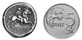
Left: a Celtic Biatec coin. Right: five Slovak crowns.
-
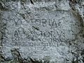
A Roman inscription at the castle hill of Trenčín (178–179 AD).
-
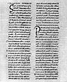
Scire vos volumus, a letter written in 879 by Pope John VIII to Svatopluk I.
-
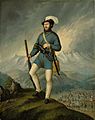
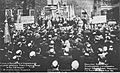
Captain Ján Francisci-Rimavský, a leader of Slovak volunteers during the Slovak Uprising of 1848–49.
-
Czechoslovak declaration of independence by Tomáš Garrigue Masaryk in the United States, 1918.
-
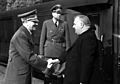
Adolf Hitler greeting Jozef Tiso, president of the (First) Slovak Republic, a state allied with Nazi Germany during World War II, 1941.
-
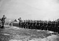
Troops of the Slovak anti-Nazi resistance movement in 1944.
-
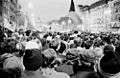
The Velvet Revolution ended 41 years of Communist rule in Czechoslovakia in 1989.
-
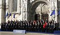
Slovakia became a member of the European Union in 2004 and signed the Lisbon Treaty in 2007.
-
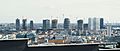
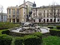
National Bank of Slovakia in Bratislava.
-
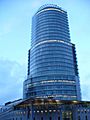
High-rise buildings in Bratislava's new business district.
-
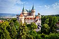
Bojnice Castle.
-
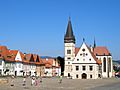
The center of Bardejov – a UNESCO World Heritage Site.
-
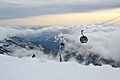
Cable cars at Jasná in the Tatra Mountains.
-
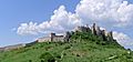
Spiš Castle.
-
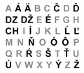
The Slovak alphabet has 46 characters.
-
Comenius University headquarters in Bratislava.
-
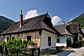
Wooden folk architecture can be seen in the well-preserved village of Vlkolínec, a UNESCO World Heritage Site.
-
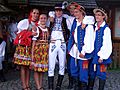
Slovaks wearing folk costumes from Eastern Slovakia.
-
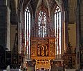
The main altar in the Basilica of St. James, made by Master Paul of Levoča in 1517. It is the tallest wooden altar in the world.
-
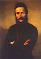
Ľudovít Štúr, who helped create the standard Slovak language.
-
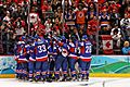
The Slovak national ice hockey team celebrating a victory against Sweden at the 2010 Winter Olympics.
-
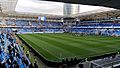
The football stadium Tehelné pole in Bratislava. Football is the most popular sport in Slovakia.


.jpg)


.jpg)


.jpg)


See also
 In Spanish: Eslovaquia para niños
