Antwerp Province facts for kids
Quick facts for kids
Antwerp Province
(Dutch: Provincie Antwerpen)
|
|||
|---|---|---|---|
|
|||
 |
|||
| Country | |||
| Region | |||
| Capital (and largest city) |
Antwerp | ||
| Area | |||
| • Total | 2,876 km2 (1,110 sq mi) | ||
| Population
(1 January 2019)
|
|||
| • Total | 1,857,986 | ||
| • Density | 646.03/km2 (1,673.21/sq mi) | ||
| ISO 3166 code | BE-VAN | ||
| HDI (2019) | 0.945 very high · 4th of 11 |
||
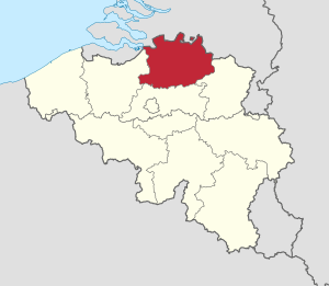
Antwerp Province (called Provincie Antwerpen in Dutch) is the northernmost province in both the Flemish Region (also known as Flanders) and Belgium. It shares a border with the North Brabant province in the Netherlands to the north. It also borders the Belgian provinces of Limburg, Flemish Brabant, and East Flanders.
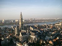
The capital city of Antwerp Province is Antwerp. This city is home to the Port of Antwerp, which is the second-largest seaport in Europe. The province covers an area of 2,876 square kilometers. As of January 2019, it had over 1.85 million people, making it the most populated province in Belgium. Antwerp Province is divided into three main areas called arrondissements: Antwerp, Mechelen, and Turnhout. The eastern part of the province is mostly covered by the Campine region.
Contents
History of Antwerp Province
During the early Middle Ages, the area that is now Antwerp Province was part of the Frankish Empire. This empire was split into smaller regions called pagi. The area around the city of Antwerp was part of the Pagus Renesium. Another region, the Pagus Toxandria, stretched from North Brabant into the Campine area.
In 843, the Carolingian Empire (which was once ruled by Charlemagne) was divided. The Scheldt river became the border between West Francia and East Francia. Later, in 974, Otto II created the Margraviate of Antwerp. This was a defense area against the County of Flanders.
In 1106, the Margraviate was given to Godfrey I of Leuven. His family later became the Dukes of Brabant, and this region was the northern part of the Duchy of Brabant. Over time, the Duchy became part of the Duchy of Burgundy in 1430, and then the House of Habsburg in 1477. After the Spanish Succession War in 1713, it became part of the Austrian Netherlands.
In 1795, the French took over the Austrian Netherlands. The modern province was formed during the First French Empire and was called the Department of the two Netes. After Napoleon's defeat, the area became part of the United Kingdom of the Netherlands and was known as Central Brabant. This name helped tell it apart from North Brabant and South Brabant. In 1830, after Belgium became independent, the province was renamed Antwerp, after its main city.
Population Growth
The number of people living in Antwerp Province has grown a lot over the years:
- 1846: 406,354 people
- 1900: 819,159 people
- 1930: 1,173,363 people
- 2008: 1,715,707 people
- 2010: 1,744,862 people
Language
Like all Flemish provinces, the main language spoken in Antwerp Province is Dutch. The local way of speaking Dutch here is a type of Brabantian dialect, similar to those in Flemish Brabant, North Brabant, and Brussels.
Religion
Religion in Antwerp (2008) Roman Catholicism (73.3%) Non-religious (24.1%) Other religion (2.6%)
Based on a study from 2008, most people in Antwerp Province, about 73.3%, identify as Catholics. Around 24.1% say they are not religious, and 2.6% follow other religions.
Government
Antwerp Province has a provincial council, which is a group of elected officials. These officials are chosen every six years. The province is led by an executive group called the deputation, and at the very top is a governor. The current governor is Cathy Berx, who started her role in 2008.
The most recent elections for the provincial council were held on October 14, 2018. Here are the parties that won seats in the 36-member council:
- New Flemish Alliance (N-VA): 14 seats
- Christian Democratic and Flemish (CD&V): 6 seats
- Flemish Interest (Vlaams Belang): 6 seats
- Green (Groen): 5 seats
- Open Flemish Liberals and Democrats (Open Vld): 2 seats
- Socialist Party – Different (sp.a): 2 seats
- Workers' Party of Belgium (PVDA+): 1 seat
Geography
- Highest point: The Beerzelberg, which is 55 meters high. It is located in the municipality of Putte.
- Important rivers: The Scheldt, Rupel, Grote Nete, and Kleine Nete.
Transportation
Antwerp Province has a modern network of roads, railroads, canals, and rivers. This network is very important for connecting the Port of Antwerp with the Ruhr Area in Germany. Major highways like the E313 (also called the King Baudouin highway) and E34 link Antwerp to the Ruhr Area. The Iron Rhine railroad also connects these regions.
Important European highways that pass through the province include the E313, E19, and E34. The Kennedy Tunnel and the Liefkenshoek Tunnel connect the province's highway system to East Flanders and Ghent.
The railroads connect major cities within the province, such as Antwerp, Mechelen, Herentals, Turnhout, and Mol. High-speed trains connect Antwerpen-Centraal railway station to Brussels and Amsterdam. Antwerp International Airport, located in Deurne, is a regional airport.
The Schelde river is a vital waterway that links the Port of Antwerp to the North Sea. The Albert Canal connects the Scheldt in Antwerp with the Meuse river and Liège. Other canals include the Canal Dessel – Kwaadmechelen, Schoten – Turnhout – Dessel, and Herentals – Bocholt.
Tourism

The province is home to several historic cities like Antwerp, Mechelen, Turnhout, Herentals, and Lier. The Campine region is becoming a popular spot for tourists looking for a quiet and relaxing getaway. Many old farms have been turned into bed and breakfast hotels. There are also many restaurants and cafes, and a great network of bicycle paths has been created.
You can still find large areas of heathland and forests, such as the Kalmthoutse Heide (Kalmthout heathland) in Kalmthout, the moors near Turnhout, the Liereman (Oud-Turnhout), and the Prinsenpark in Retie. In some villages, you can still see the traditional Campine langgevelboerderijen (long facade farms).
Education and Research
Antwerp Province has many schools and is home to the University of Antwerp. Several important research centers are also located here, such as the SCK•CEN, the European Institute for Reference Materials and Measurements (IRMM), and the Flemish Institute for Technological Research (VITO).
International schools in Antwerp include the Antwerp International School and the Lycée Français International d'Anvers.
Economy
The total value of goods and services produced in the province, known as GDP, was 88 billion Euros in 2018. This means the average person in Antwerp Province produced goods and services worth 41,900 Euros, which is much higher than the average for the European Union.
The Port of Antwerp is the most important part of the province's economy. Before the farming crisis in 1880, the eastern part of the province was mostly farmland. Industrial growth in the eastern Campine region began in the late 1800s. New roads, canals, and railroads helped new industries set up there. For example, brick factories were built along the canals, and paper and printing businesses started in Turnhout. Other industries included metal production in Balen-Nete, dynamite factories in Arendonk and Balen, and tobacco and shoe factories in other towns.
In the 1920s, more industries grew, like radium and copper factories in Olen, a glass factory in Mol-Gompel, and diamond businesses in Grobbendonk and Nijlen. In 1962, the first nuclear facility in Belgium was built at the SCK•CEN in Mol. The European Institute for Reference Materials and Measurements (IRMM) was founded in Geel in 1957. Today, industries in the Campine region are mainly found along the E313, E34 highways, and the Albert Canal.
Unemployment
In 2017, the unemployment rate in Antwerp Province was 5.9%, which was lower than the national average for Belgium.
Chemical Industry
After World War II, the Port of Antwerp expanded, and many chemical factories and oil refineries were built there. Big companies like Bayer, BASF, and Monsanto have facilities in the port area. This region has the world's second-largest group of petrochemical industries, after Houston in the United States. Other chemical companies like Amoco Chemical Belgium N.V. (now part of BP) and Janssen Pharmaceutica also set up in the province.
Diamond Industry
The diamond industry and trade have traditionally been centered in Antwerp. In the late 1800s, diamond-cutting companies also started outside Antwerp, in places like Grobbendonk and Nijlen.
Paper Industry
The area around Turnhout became famous for its printing businesses. Companies like Brepols have been printing there since 1796. Later, other well-known companies like Cartamundi, a world leader in playing cards, were established.
Metal Industry
While another part of Belgium, Wallonia, was known for steel, the Campine region became known for its non-ferrous metal industries (metals other than iron or steel). Because the Campine region was not very populated and had good transport links, several metal factories were built there. These included companies that produced zinc, radium, cobalt, and copper.
Glass Industry
In 1872, a company called Sablières et Carrières Réunies (now Sibelco) was founded to get silica sand from Mol for making glass. Later, glass bottle manufacturers and large glass companies like Glaverbel were established in the area.
Dynamite Production
Since the Campine region was not very populated, several dynamite factories were built there. These factories produced explosives for mines and quarries. However, these factories in the province are now closed.
Textile Industry
Historically, the textile industry in the province focused on processing wool from sheep that lived on the Campine heath. Turnhout was a main center for textile production.
Tobacco Industry
In the late 1800s, Arendonk became a center for the tobacco industry. More factories were later founded in Turnhout, Mol, Geel, and Herentals.
Administrative subdivisions
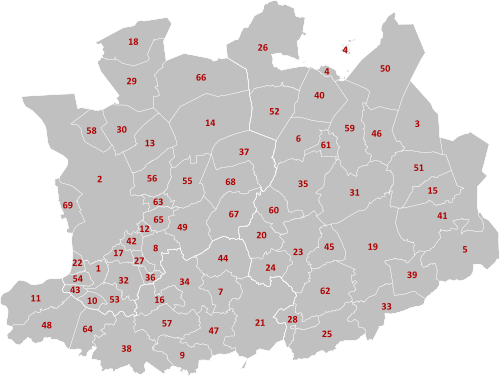
The province is divided into three main administrative areas called arrondissements. These contain 69 smaller areas called municipalities. The numbers next to the names below refer to their location on the map shown in this section.
| Arrondissement of Antwerp: | Arrondissement of Mechelen: | Arrondissement of Turnhout: |
|
|
|
See Also
 In Spanish: Provincia de Amberes para niños
- CIPAL
- List of schools in Antwerp
 | Valerie Thomas |
 | Frederick McKinley Jones |
 | George Edward Alcorn Jr. |
 | Thomas Mensah |


