
Chaco Culture National Historical Park facts for kids
Quick facts for kids Chaco Culture National Historical Park |
|
|---|---|

Great kiva of Chetro Ketl
|
|

Park map
|
|
| Location | San Juan County and McKinley County, New Mexico, US |
| Area | 33,977.8 acres (137.50 km2) |
| Architectural style(s) | Ancient Puebloan |
| Visitors | 41,594 (in 2022) |
| Governing body | National Park Service |
| Website | Chaco Culture National Historical Park |
| Official name: Chaco Culture | |
| Type | Cultural |
| Criteria | iii |
| Designated | 1987 (11th session) |
| Reference no. | 353 |
| Region | Europe and North America |
| Type | historic district |
| Designated | October 15, 1966 |
| Reference no. | 66000895 |
|
Former U.S. National Monument
|
|
| Designated | March 11, 1907 |
| Delisted | December 19, 1980 |
| Designated by | President Theodore Roosevelt |
| Designated | December 19, 1980 |
| Designated | May 21, 1971 |
| Reference no. | 57 |
| Lua error in Module:Location_map at line 420: attempt to index field 'wikibase' (a nil value). | |
Chaco Culture National Historical Park is a special place in the Southwestern United States. It protects many ancient buildings called pueblos. This park is in a remote canyon in northwestern New Mexico. It holds some of the most amazing ancient ruins north of Mexico. It is one of the most important historical areas in the United States.
Between the years AD 900 and 1150, Chaco Canyon was a major cultural hub for the Ancestral Puebloans. These people, called Chacoans, cut sandstone blocks and brought timber from far away. They built fifteen large complexes. These were the biggest buildings in North America until the 1800s.
Scientists think the Chacoans studied the sky. They may have used the "Sun Dagger" petroglyph at Fajada Butte to track the sun and moon. Many Chacoan buildings might have been built to line up with the sun and moon cycles. This would have taken many years of watching the sky and careful building.
A big drought started around 1130. This climate change likely caused the Chacoans to leave the canyon. The park is now a World Heritage Site by UNESCO. It is in the dry Four Corners region. The ancient sites are delicate. Because of this, Fajada Butte is closed to visitors to prevent damage.
The Hopi and Pueblo people see these sites as sacred homelands. They have stories about their ancestors moving from Chaco. They also feel a deep connection to the land. The National Park Service works with tribal leaders. They share knowledge and respect the Chacoan culture. The park is part of the Trails of the Ancients Byway.
Contents
Exploring Chaco Canyon's Landscape
Chaco Canyon is in the San Juan Basin. It sits on the huge Colorado Plateau. Mountains like the Chuska Mountains and San Juan Mountains surround it. Ancient Chacoans used wood from oak, piñon, and juniper trees.
The canyon runs from northwest to southeast. It has flat-topped hills called mesas. Large gaps in the cliffs, called rincons, helped bring rain into the canyon. Important Chacoan sites like Pueblo Bonito are high up. They are about 6,200 to 6,440 feet (1,890 to 1,963 meters) above sea level.
The canyon floor slopes gently. The Chaco Wash is a dry riverbed that rarely has water. The ancient Chacoans could not use the deep underground water. They relied on smaller, shallower springs for water. Today, there is almost no surface water except for occasional storm runoff.
Chaco's Ancient Climate

Chaco Canyon is a dry area with desert plants. It gets about 8 to 9 inches (200 to 230 mm) of rain each year. The canyon is on the side of mountains that block rain. This creates a rain shadow effect, making the area very dry.
Chaco has four clear seasons. Most rain falls between July and September. May and June are the driest months. Rain also comes from storms that rise over the mountains.
The weather in Chaco can change a lot. Temperatures can go from -38°F (-39°C) to 102°F (39°C). They can even change 60°F (33°C) in one day. The region has fewer than 150 days without frost each year. The climate can swing from very wet years to long droughts.
Plants and Animals of Chaco
Chaco's plants are typical for high deserts in North America. You can find sagebrush and different types of cactus. There are also dry forests of piñon and juniper trees, mostly on the mesa tops. The canyon is much drier than other parts of New Mexico at the same height. It does not have many temperate coniferous forests like areas to the east.
In ancient times, there were not many plants or animals. Too many people, farming, hunting, and droughts might have made the canyon lose its wild plants and game. Some think the canyon could only support about 2,000 people, even when it was wet.
Many coyotes live in Chaco. You might also see mule deer, elk, and pronghorn, but they are rare. Smaller meat-eating animals include bobcats, badgers, foxes, and skunks. The park has many prairie dog towns. Small groups of bats are there in the summer.
Because there is little water, not many bird species live here. These include roadrunners, large hawks, owls, vultures, and ravens. Smaller birds like warblers, sparrows, and house finches are common. Three kinds of hummingbirds live here, including the tiny rufous hummingbird. You might also see Western rattlesnakes, but lizards and skinks are more common.
Chaco's Long History
Early People and Basketmakers
The first people in the San Juan Basin were hunter-gatherers. They were called the Archaic–Early Basketmaker people. They came from nomadic hunters who arrived in the Southwest around 10,000 BC. Over 70 campsites from this time have been found in Chaco Canyon. These sites show they made tools, gathered plants, and hunted animals. They started making baskets to store food. Later, some began to grow their own food.
The Ancestral Puebloans

By AD 490, the descendants of these people, called Late Basketmakers, farmed lands around Shabik'eshchee Village in Chaco. By AD 800, during the Pueblo I Era, they built crescent-shaped stone buildings. These had homes and underground rooms called kivas for ceremonies. These buildings are typical of the Early Pueblo People.
By AD 850, the Ancestral Puebloan population grew quickly. They lived in bigger, more crowded pueblos. There is strong proof that they worked with turquoise in the 900s. Around this time, the first part of Pueblo Bonito was built. It was a curved row of 50 rooms.
The Chacoan way of life began to fall apart around 1140. This might have been due to a very bad 50-year drought that started in 1130. There were also other droughts between 1250 and 1450. Poor water management led to dry riverbeds. They also cut down too many trees. Wood for building had to be brought from mountains over 50 miles (80 km) away.
Communities outside the canyon started to empty out. By the end of the 1100s, the buildings in the main canyon were sealed up and left empty. Some experts think violence or war caused people to leave. But Chacoan buildings do not show much sign of being attacked. Scientists believe people from this area moved south, east, and west. They went to the valleys of the Little Colorado River, the Rio Puerco, and the Rio Grande.
Later Native American Groups

People who spoke Numic languages, like the Ute and Shoshone, arrived on the Colorado Plateau in the 1100s. Later, nomadic groups speaking Southern Athabaskan languages, like the Apache and Navajo, came to this region by the 1400s. They learned Chacoan customs and farming skills. Ute groups also visited the area for hunting. The modern Navajo Nation is west of Chaco Canyon. Many Navajo people live in the areas around the park.
Discovering and Protecting the Park
The first recorded trip through Chaco Canyon was in 1823. New Mexican governor José Antonio Vizcarra led it. He saw several large ruins. In 1849, a U.S. Army group surveyed the ruins. But the canyon was so remote that few people visited for the next 50 years.
Formal archaeological work began in 1896. A team from the American Museum of Natural History started digging at Pueblo Bonito. They spent five summers there. They sent over 60,000 artifacts back to New York.
In 1901, Richard Wetherill claimed land that included Pueblo Bonito. A federal agent named Samuel J. Holsinger studied Wetherill's claim. He wrote a report about the canyon and its sites. He noted ancient roads and stairways. He also saw old dams and irrigation systems. His report suggested creating a national park to protect the sites.
In 1906, the Federal Antiquities Act was passed. This was the first U.S. law to protect old relics. It was a direct result of Wetherill's actions at Chaco. On March 11, 1907, President Theodore Roosevelt declared Chaco Canyon a National Monument. Wetherill gave up his land claims.

In 1920, the National Geographic Society began studying Chaco Canyon. Neil Judd led the project. He spent seven summers digging at Pueblo Bonito. His team found many artifacts. They also found that most of the wood beams used in Chaco were cut between 1033 and 1092. This was when most of the building happened.
In 1949, the University of New Mexico gave more land to expand the Chaco Canyon National Monument. In return, the university kept rights to do scientific research there. By 1959, the National Park Service built a visitor center and campgrounds.
In 1971, researchers started the "Chaco Center." This group did cultural research with the University of New Mexico and the National Park Service. They surveyed the Chacoan roads. These were well-built roads that spread out from the main canyon.
The park was made bigger and renamed Chaco Culture National Historical Park on December 19, 1980. It became a World Heritage Site in 1987. Today, over 2,400 archaeological sites have been found in the park. Only a small number of these have been dug up.
Managing Chaco Culture Park


The National Park Service manages Chaco Culture National Historical Park. Other federal lands with Chacoan roads are managed by the Bureau of Land Management. The park has a visitor center with a museum, information desk, theater, and gift shop. It also has an observatory.
Before the 1980s, archaeologists dug up many sites. They took apart walls and removed thousands of artifacts. But starting in 1981, a new approach began. This approach respected traditional Hopi and Pueblo beliefs. They stopped digging up sites. Instead, they used remote sensing and studied Native American oral traditions.
The "Chaco American Indian Consultation Committee" was created in 1991. This group gives Navajo, Hopi, Pueblo, and other Native American groups a say in how the park is run.
Today, the park tries to restore excavated sites. They also try to protect the ancient feel of the area. The "Chaco Night Sky Program" works to reduce light pollution. This helps visitors enjoy the amazing night skies. The park was named a Gold-tier Dark Sky Park in 2013.
Ancient Chacoan sites outside the park have been threatened by development. For example, there were plans to mine coal near the park. This mining could have damaged the old Chacoan roads. So, the "Chaco Roads Project" documented the roads. They were later protected from mining. The U.S. Department of the Interior plans to create a 10-mile (16 km) buffer zone around the park. This will protect it from future development.
Amazing Ancient Sites
The Chacoans built their complexes along a 9-mile (14 km) stretch of the canyon floor. Some buildings were lined up with the four main directions (north, south, east, west). Others were aligned with the 18.6-year cycle of the moon's rise and set.
Central Canyon Wonders

The middle of the canyon has the largest Chacoan complexes. Pueblo Bonito is the most studied. It covers almost 2 acres (0.8 hectares) and has at least 650 rooms. Some parts were four stories high. The builders used special masonry (stone work) and thick walls. Pueblo Bonito is split into two parts by a wall that runs exactly north-south. A large kiva was on each side of this wall. This created a balanced pattern seen in many Chacoan great houses.


Nearby is Pueblo del Arroyo. It was started between AD 1050 and 1075. It sits at a drainage outlet called South Gap.
Casa Rinconada is separate from the other central sites. It is south of Chaco Wash. It has a single kiva with no homes around it. It once had a 39-foot (12 m) passage leading from the underground kiva.
Chetro Ketl is near Pueblo Bonito. It has a 'D' shape, like many other central complexes. It was started between 1020 and 1050. It had 450–550 rooms and one great kiva. Experts think it took 29,135 hours to build Chetro Ketl. It used wood from 5,000 trees and 50 million stone blocks.
Kin Kletso ("Yellow House") was a medium-sized complex. It is about 0.5 miles (0.8 km) west of Pueblo Bonito. It shows signs of being built by Pueblo people from the northern San Juan Basin. It has a rectangular shape and 55 rooms. It also has a two-story round tower that might have been a kiva. People found evidence of a workshop for obsidian tools near the village. It was built between 1125 and 1130.

Pueblo Alto is a great house with 89 rooms. It is on a mesa top near the middle of Chaco Canyon. It was started between AD 1020 and 1050. Its location made it visible to most people in the San Juan Basin. It was a center for making beads and working with turquoise. Only a few families lived there. This suggests Pueblo Alto was not mainly for living. Another great house, Nuevo Alto, was built nearby in the late 1100s. This was when the Chacoan population was shrinking.
Outlying Communities
Another group of great houses is in Chaco's northern areas. One of the largest is Casa Chiquita ("Small House"). It was built in the 1080s. It had a smaller, squarer shape. It did not have open plazas or separate kivas like older buildings. Larger, squarer stone blocks were used in its walls. Its kivas were built in the northern Mesa Verde style.
Two miles (3.2 km) down the canyon is Peñasco Blanco ("White Bluff"). It is an arc-shaped building on the canyon's southern rim. It was built in five steps between 900 and 1125. A nearby cliff painting might show the SN 1054 supernova seen on July 5, 1054.

Hungo Pavi is about 1 mile (1.6 km) from Una Vida. It was 872 feet (266 m) around. It had 72 ground-level rooms and was four stories high. It also had one large circular kiva. Kin Nahasbas was built in the 800s or 900s. It is north of Una Vida.
Tsin Kletzin ("Charcoal Place") is on the Chacra Mesa. It is about 2.3 miles (3.7 km) south of Pueblo Alto. Nearby is Weritos Dam. Scientists believe this huge earthen dam provided water for Tsin Kletzin. It held stormwater runoff in a reservoir.

Deeper in the canyon, Una Vida ("One Life") is one of the three oldest great houses. Building started around 900. It had at least two stories and 124 rooms. It has an arc or D-shape, like Pueblo Bonito. But it has a unique "dog leg" addition because of the land. It is near Gallo Wash and was greatly expanded after 930.
Wijiji ("black greasewood") has just over 100 rooms. It is the smallest great house. Built between 1110 and 1115, it was the last Chacoan great house constructed. It is about 1 mile (1.6 km) from Una Vida.
North of Chaco Canyon are even more distant communities. Salmon Ruins and Aztec Ruins are on the San Juan and Animas Rivers near Farmington. They were built during a wet period starting in 1100. About 60 miles (97 km) south of Chaco Canyon, on the Great South Road, are other communities. The largest is Kin Nizhoni.
Casamero Pueblo is near Tecolote Mesa. It was connected to a nearby site, Andrews Ranch, by a Chacoan road. Chaco Canyon, Aztec Ruins, Salmon Ruins, and Casamero Pueblo are all part of the Trail of the Ancients Scenic Byway.
Understanding Chaco's Buildings
Great Houses: Ancient Skyscrapers

The huge buildings called "great houses" were central to Chacoan life. The Chacoans used building methods that were special for their time. Their buildings took decades, even centuries, to finish.
These houses had some common features. They were very large, with over 200 rooms each. Some had up to 700 rooms. The rooms were big, with higher ceilings than earlier Puebloan buildings. They were well-planned, with large sections built all at once.
Houses usually faced south. Plaza areas were often surrounded by walls or sealed-off rooms. Houses were often four or five stories tall. Rooms on the ground floor facing the plaza were usually single-story. The tallest parts were at the back of the pueblo. Rooms were often grouped into suites. Front rooms were larger than back rooms or storage areas.
Ceremonial buildings called kivas were built based on the number of rooms. There was one small kiva for about every 29 rooms. Nine complexes had very large great kivas, up to 63 feet (19 m) across. All Chacoan kivas had T-shaped doorways and stone lintels (beams over openings).
Great houses were mostly built with "core-and-veneer" walls. These had two parallel load-bearing walls made of flat sandstone blocks. The space between the walls was filled with rubble. Then, small sandstone pieces were pressed into mud on the outside. These stones were often placed in special patterns. All the Chacoan buildings needed wood from 200,000 evergreen trees. This wood was carried by hand from mountains up to 70 miles (113 km) away.
What Were They Used For?

The carefully designed Chacoan buildings appeared around AD 1030. The Chacoans combined building plans, sky alignments, geometry, and engineering. They created unique ancient urban centers. Researchers think that only a small number of people lived in these complexes. Larger groups might have gathered there for yearly ceremonies. Smaller, more residential sites were scattered around the great houses. The canyon itself lines up with lunar cycles. This suggests the location was chosen for its importance to sky watching.

Turquoise was very important to the Chaco people. About 200,000 pieces of turquoise have been found at Chaco Canyon. Workshops for making turquoise beads have also been found. The turquoise was used for special items buried with people, and for ceremonies. Over 15,000 turquoise beads and pendants were found with two burials at Pueblo Bonito. Some researchers believe turquoise was traded widely.
Around this time, the Ancestral Puebloan population and building activity grew a lot. By AD 1115, at least 70 outlying pueblos with Chacoan features were built. These were spread over 25,000 square miles (64,750 sq km) in the San Juan Basin. Experts wonder what these large communities were for. Some think they were more than just farming villages. They might have been trading posts or ceremonial sites.
Thirty such outlying sites are connected to the central canyon by a network of six Chacoan road systems. These roads stretch up to 60 miles (97 km) in mostly straight lines. They seem to have been carefully planned. They are about 30 feet (9 m) wide. Earthen mounds or rocks sometimes form low walls along their edges. When needed, the roads used steep stone stairways and ramps to go over cliffs. No one is completely sure of their purpose. Some believe the Anasazi built the roads to transport timber.
Chaco and the Stars
The Sun Dagger Mystery

Two spiral carvings near the top of Fajada Butte are called the "Sun Dagger" petroglyph. They are hidden behind three rock slabs. These carvings are very important.
One spiral, on the left, marked both spring and fall equinoxes. A spear of light, coming through the slabs, would shine on it and split it in two. The larger spiral on the right was lit by the "sun dagger." This light would split it in half when the summer sun was at its highest point. The Chacoans might have been marking "the middle of time."
Each turn of the large spiral marked one year in the 18.6-year "lunar excursion cycle." This cycle tracks the rising of the mid-winter full moon. A shadow from a slab would hit each ring in succession. When the full "minimum moon" (closest to the winter solstice) rises, the shadow hits the center of the spiral. It then moves outward year by year until it hits the outermost edge during the full "maximum moon."
Fajada Butte has five other rock carvings. These include a "rattlesnake," other spirals, and a rectangle. These are lit up by sunbeams and shadows during equinoxes or solstices. Public access to the butte was stopped in 1989. This was because foot traffic caused one of the three slabs at the "Sun Dagger" site to move. This made the calendar less accurate. The stones were made stable in 1990, but the moved slab was not put back.
Building Alignments

Some people think that at least 12 of the 14 main Chacoan complexes were built to line up with each other. They believe these buildings were oriented along lines that showed the sun and moon at important times.
Casa Rinconada was one of the first great houses to show careful alignment. Its two T-shaped doorways were perfectly aligned north-south. The great houses of Pueblo Bonito and Chetro Ketl are on an exact east-west line. This line marks the path of the sun during the equinox. The lines that cut through their main walls are aligned north-south. This might mean they were meant to reflect the midday sun at the equinox. Pueblo Alto and Tsin Kletsin are also aligned north-south.
These two lines form an upside-down cross when seen from above. The northern part of this cross extends another 35 miles (56 km) past Pueblo Alto. This is the very straight Great North Road. Modern Pueblo Indians believe this road is a reference to myths about their ancestors coming from the north.

Two complexes, Pueblo Pintado and Kin Bineola, are about 15 miles (24 km) from the main canyon buildings. They are on a path from the central canyon that lines up with the setting of the full mid-winter "minimum moon." This happens every 18.6 years. Two other complexes, Una Vida and Peñasco Blanco, line up with the path of the full "maximum moon." "Minimum" and "maximum" refer to the moon's extreme points in its cycle. It takes about 9.25 years for the full moon closest to the winter solstice to move from its northernmost point to its southernmost point.
Gallery
-
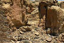
Chaco Prehistoric Stairway, Chaco National Cultural Historic Park, New Mexico
-
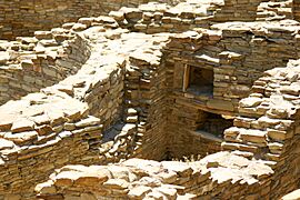
Chaco Kiva Detail, Chaco Culture National Historic Park, New Mexico
-
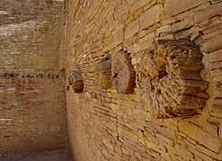
Chaco interior wall, showing log and stone construction, Chaco Cultural Historic Park, New Mexico
-
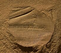
Early Graffiti, Chaco Culture National Historic Park, New Mexico
-
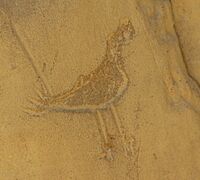
Chaco Pictograph, Chaco Culture Historical Park, New Mexico
-
Pueblo Bonito from far away


See also
 In Spanish: Cañón del Chaco para niños
