Charles County, Maryland facts for kids
Quick facts for kids
Charles County
|
|||
|---|---|---|---|

|
|||
|
|||

Location within the U.S. state of Maryland
|
|||
 Maryland's location within the U.S. |
|||
| Country | |||
| State | |||
| Founded | April 13, 1658 | ||
| Named for | Charles Calvert, 3rd Baron Baltimore | ||
| Seat | La Plata | ||
| Largest community | Waldorf | ||
| Area | |||
| • Total | 643 sq mi (1,670 km2) | ||
| • Land | 458 sq mi (1,190 km2) | ||
| • Water | 185 sq mi (480 km2) 29% | ||
| Population
(2020)
|
|||
| • Total | 166,617 |
||
| • Density | 363.8/sq mi (140.5/km2) | ||
| Time zone | UTC−5 (Eastern) | ||
| • Summer (DST) | UTC−4 (EDT) | ||
| Congressional district | 5th | ||
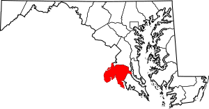
Charles County is a county located in the U.S. state of Maryland. As of the 2020 census, the population was 166,617. The county seat is La Plata. The county was named for Charles Calvert (1637–1715), third Baron Baltimore. Charles County is part of the Washington metropolitan area and the Southern Maryland region.
With a median household income of $103,678, Charles County is the 39th-wealthiest county in the United States as of 2020, and the highest-income county in the United States with a Black-majority population.
Contents
History
Charles County was created in 1658 by an Order in Council. There was also an earlier Charles County from 1650 to 1654, sometimes referred to in historic documents as Old Charles County, which consisted largely of lands within today's borders but "included parts of St. Mary’s, Calvert, present-day Charles, and Prince George’s County". John Tayloe I purchased land around Nanjemoy Creek after 1710 from which to mine iron and ship to his furnaces at Bristol Iron Works, Neabsco Iron Works and later Occoquan Ironworks.
In April 1865, John Wilkes Booth made his escape through Charles County after shooting President Abraham Lincoln. He was on his way to Virginia. He stopped briefly in Waldorf (then called Beantown) and had his broken leg set by local Doctor Samuel Mudd, who was later sent to prison for helping him. Booth then proceeded to hide in the Zekiah Swamp in Charles County, avoiding search parties for over a week until he and his accomplice were able to successfully cross the Potomac River.
In 1926, a tornado ripped through the county leaving 17 dead (including 13 schoolchildren). On April 28, 2002, another tornado (rated an F-4) destroyed much of downtown La Plata killing 3 and injuring over 100 people.
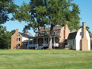
The county has numerous properties on the National Register of Historic Places. Among them are Green Park and Pleasant Hill, home of the Green and Spalding Families.
On December 4, 2004, an arson took place in the development of Hunters Brooke, a few miles southeast of Indian Head. The Hunters Brooke Arson was the largest residential arson in Maryland history.
Geography
According to the U.S. Census Bureau, the county has an area of 643 square miles (1,670 km2), of which 458 square miles (1,190 km2) is land and 185 square miles (480 km2) (29%) water.
In its western wing, along the southernmost bend in Maryland Route 224, Charles County contains a place due north, east, south, and west of the same state—Virginia.
Adjacent counties
- Prince George's County (north)
- Fairfax County, Virginia (northwest)
- Calvert County (east)
- Stafford County, Virginia (west)
- Prince William County, Virginia (west)
- St. Mary's County (southeast)
- Westmoreland County, Virginia (southeast)
- King George County, Virginia (south)
National protected area
Demographics
| Historical population | |||
|---|---|---|---|
| Census | Pop. | %± | |
| 1790 | 20,613 | — | |
| 1800 | 19,172 | −7.0% | |
| 1810 | 20,245 | 5.6% | |
| 1820 | 16,500 | −18.5% | |
| 1830 | 17,769 | 7.7% | |
| 1840 | 16,023 | −9.8% | |
| 1850 | 16,162 | 0.9% | |
| 1860 | 16,517 | 2.2% | |
| 1870 | 15,738 | −4.7% | |
| 1880 | 18,548 | 17.9% | |
| 1890 | 15,191 | −18.1% | |
| 1900 | 17,662 | 16.3% | |
| 1910 | 16,386 | −7.2% | |
| 1920 | 17,705 | 8.0% | |
| 1930 | 16,166 | −8.7% | |
| 1940 | 17,612 | 8.9% | |
| 1950 | 23,415 | 32.9% | |
| 1960 | 32,572 | 39.1% | |
| 1970 | 47,678 | 46.4% | |
| 1980 | 72,751 | 52.6% | |
| 1990 | 101,154 | 39.0% | |
| 2000 | 120,546 | 19.2% | |
| 2010 | 146,551 | 21.6% | |
| 2020 | 166,617 | 13.7% | |
| 2023 (est.) | 171,973 | 17.3% | |
| U.S. Decennial Census 1790-1960 1900-1990 1990-2000 2010 2020 |
|||
2020 census
| Race / Ethnicity (NH = Non-Hispanic) | Pop 2000 | Pop 2010 | Pop 2020 | % 2000 | % 2010 | % 2020 |
|---|---|---|---|---|---|---|
| White alone (NH) | 81,111 | 70,905 | 56,832 | 67.29% | 48.38% | 34.11% |
| Black or African American alone (NH) | 31,203 | 59,201 | 80,850 | 25.88% | 40.40% | 48.52% |
| Native American or Alaska Native alone (NH) | 858 | 877 | 995 | 0.71% | 0.60% | 0.60% |
| Asian alone (NH) | 2,169 | 4,296 | 5,624 | 1.80% | 2.93% | 3.38% |
| Pacific Islander alone (NH) | 66 | 87 | 147 | 0.05% | 0.06% | 0.09% |
| Some Other Race alone (NH) | 199 | 243 | 957 | 0.17% | 0.17% | 0.57% |
| Mixed Race or Multi-Racial (NH) | 2,218 | 4,683 | 9,535 | 1.84% | 3.20% | 5.72% |
| Hispanic or Latino (any race) | 2,722 | 6,259 | 11,677 | 2.26% | 4.27% | 7.01% |
| Total | 120,546 | 146,551 | 166,617 | 100.00% | 100.00% | 100.00% |
2010 census
As of the 2010 United States Census, there were 146,551 people, 51,214 households, and 38,614 families residing in the county. The population density was 320.2 inhabitants per square mile (123.6/km2). There were 54,963 housing units at an average density of 120.1 per square mile (46.4/km2). The racial makeup of the county was 50.3% white, 41.0% black or African American, 3.0% Asian, 0.7% American Indian, 0.1% Pacific islander, 1.3% from other races, and 3.7% from two or more races. Those of Hispanic or Latino origin made up 4.3% of the population. In terms of ancestry, 12.6% were German, 10.8% were Irish, 8.7% were English, 6.3% were American, and 5.1% were Italian.
Of the 51,214 households, 41.6% had children under the age of 18 living with them, 54.2% were married couples living together, 16.3% had a female householder with no husband present, 24.6% were non-families, and 19.8% of all households were made up of individuals. The average household size was 2.83 and the average family size was 3.24. The median age was 37.4 years.
The median income for a household in the county was $88,825 and the median income for a family was $98,560. Males had a median income of $62,210 versus $52,477 for females. The per capita income for the county was $35,780. About 3.7% of families and 5.2% of the population were below the poverty line, including 6.8% of those under age 18 and 4.6% of those age 65 or over.
Economy
Top employers
According to the 2022 publication "Meet Charles County" of the County Department of Economic Development, its top employers are:
| # | Employer | # of Employees |
|---|---|---|
| 1 | Naval Surface Warfare Center / Naval Support Facility Indian Head | 3,834 |
| 2 | Charles County Public Schools / Board of Education | 3,701 |
| 3 | Charles County Government | 1,814 |
| 4 | University of Maryland Charles Regional Medical Center | 775 |
| 5 | Walmart / Sam's Club | 637 |
| 6 | College of Southern Maryland | 602 |
| 7 | Waldorf Chevy/Cadillac, Ford, Toyota/Scion, Dodge | 583 |
| 8 | Southern Maryland Electric Cooperative (SMECO) | 471 |
| 9 | Safeway | 465 |
| 10 | Target | 465 |
| 11 | The Wills Group | 344 |
| 12 | Lowe's | 332 |
| 13 | Chick-fil-A | 294 |
| 14 | ADJ Sheet Metal | 280 |
| 15 | Restore Health Rehabilitation, La Plata Center | 260 |
| 16 | Sagepoint Senior Living Services | 250 |
Education
Public schools
Colleges and universities
- College of Southern Maryland, in La Plata.
Transportation
Charles County is served by numerous state highways and one U.S. Highway:
Major highways
 US 301
 MD 5
MD 5 MD 5 Bus.
 MD 5 Bus.
 MD 6
MD 6 MD 210
 MD 224
 MD 225
 MD 227
 MD 228
 MD 229
 MD 231
 MD 234
 MD 254
 MD 257
 MD 381
 MD 425
 MD 426
 MD 488
 MD 925
Communities
Towns
- Indian Head
- La Plata (county seat)
- Port Tobacco Village
Census-designated places
The Census Bureau recognizes the following census-designated places in the county:
Unincorporated communities
Notable people
Colonial and Revolutionary Periods
- Charles Brooke (1636–1671) English immigrant & first Southerner to graduate from Harvard College, Class of 1655; Sheriff, Calvert County 1665
- Gustavus Richard Brown (1747–1804) Edinburgh-educated doctor; served in Revolutionary War; physician to George Washington, attended his death
- James Craik (1727–1814) Scottish immigrant; Physician General of the Continental Army; friend & physician to George Washington, attended his death
- John Hanson (1721–1783) born Port Tobacco; Founding Father of United States; Signer, Articles of Confederation; President, Confederation Congress
- Daniel of St. Thomas Jenifer (1723–1790) born Port Tobacco; Founding Father of U.S.; Delegate, Constitutional Convention; Signer, U.S. Constitution
- Capt. James Neale (1615–1684) born in London, immigrated around 1635; Member, Maryland Council; founded Wollaston Manor & Cobb Island
- Leonard Neale (1746–1817) born Port Tobacco; Jesuit President of Georgetown; Archbishop of Baltimore; first U.S.-consecrated Catholic prelate (1800)
- William Smallwood (1732–1792) Officer, Provincial Troops; Major General, 1st Maryland Regiment of the Continental Army; Governor of Maryland
- Benjamin Stoddert (1751–1813) Captain of Cavalry in the Continental Army; first U.S. Secretary of the Navy in the John Adams administration
- Thomas Stone (1743–1787) born at Poynton Manor near Port Tobacco; Founding Father of the United States; Signer, U.S. Declaration of Independence
- Andrew White (1579–1656) born in London; Jesuit with first colonists arriving on Ark & Dove; established mission to the Potapoco at Chapel Point (1641)
19th century
- George Cary (1789–1843) born near Allen's Fresh; practiced law in Frederick; moved to Appling County, Georgia; Member, U.S. House 1823-27
- Barnes Compton (1830–1898) born Port Tobacco, Princeton '51; Pres., Maryland Senate; Treasurer of Maryland; Member, U.S. House 1885–90, 91-94
- Josiah Henson (1789–1883) born into slavery in Port Tobacco; escaped to Canada & founded community of fugitive slaves; author, abolitionist & minister
- Jane Herbert Wilkinson Long (1798–1880) born Charles County; Texas Patriot & boarding-house matron; dubbed "Mother of Texas" by Sam Houston
- Samuel A. Mudd (1833–1883) born near Bryantown; physician imprisoned for aiding John Wilkes Booth after assassination of Pres. Abraham Lincoln
- Sydney E. Mudd (1858–1911) born in Gallant Green; Speaker, Maryland House of Delegates; Member, U.S. House of Reps 1890–91, 1897-1911
- Francis Neale (1756–1836) born Port Tobacco; Jesuit pastor of St. Thomas Manor & Holy Trinity, first Catholic Church in D.C., President of Georgetown
- Raphael Semmes (1809–1877) born near Nanjemoy; US Navy officer; Captain, CSS Sumter & CSS Alabama; Rear Admiral, Confederate States Navy
20th & 21st centuries
- Chuck Brown (1936–2012) "Godfather of Go-Go", a subgenre of funk that evolved in the D.C. area in the 1970s; lived in Brandywine
- Matthew Henson (1866–1955) born in Nanjemoy; African-American explorer; first to reach North Pole in 1909, with Robert Peary & 4 Inuit companions
- Larry Johnson (born 1979) from Pomfret; former NFL running back; played for K.C. Chiefs, Cincinnati Bengals, Washington Redskins & Miami Dolphins
- Shawn Lemon (born 1988) Attended Westlake H.S. in Waldorf; played with seven teams in the Canadian Football League as a defensive lineman
- Joel & Benji Madden (born 1979) Identical twins from Waldorf; both with bands The Madden Brothers & Good Charlotte; Benji married to Cameron Diaz
- Christina Milian (born 1981) Movie & TV actress; Top 40 singer/songwriter in US (Top 4 in UK); raised in Waldorf to age 13 & part of high school
- Randy Starks (born 1983) Attended Westlake in Waldorf; played NFL as a defensive end with Tennessee Titans, Miami Dolphins & Cleveland Browns
- Robert Stethem (1961–1985) U.S. Navy diver; murdered in Beirut during hijacking of TWA Flight 847; grew up in Pinefield community of Waldorf
- Turkey Tayac (1895–1978) born Charles County; Chief, one branch of Piscataway Indian Nation; WWI veteran; Medicine Man & Native American activist
- Angela Renée White a.k.a. "Blac Chyna" (born 1988) Model, socialite & television personality; attended Henry E. Lackey High School in Indian Head
Sports
| Club | League | Venue | Established | Championships |
|---|---|---|---|---|
| Southern Maryland Blue Crabs | ALPB, Baseball | Regency Furniture Stadium | 2008 | 0 |
See also
 In Spanish: Condado de Charles para niños


