Geography of St facts for kids
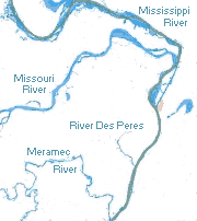
St. Louis is a cool city located in the middle of the United States, right where the Mississippi River and the Missouri River meet. You can find it at 38°38′53″N 90°12′44″W / 38.648056°N 90.212222°W.
The city is built on high ground, like natural steps or cliffs, that rise about 100 to 200 feet above the Mississippi River. The land around St. Louis is mostly flat, fertile farmland with gentle hills and wide, shallow valleys. Both the Mississippi and Missouri Rivers have carved out huge valleys with wide, flat areas that can sometimes flood.
Underneath St. Louis, there's a type of rock called limestone. Because of this, the area has many natural holes and caves, though most of the caves have been closed off. You can still see many natural springs along the river. In the past, people used to mine for coal, brick clay, and a special metal ore called millerite here. The limestone from St. Louis is also used for building houses and other structures.
There's a natural crack in the Earth's crust called the St. Louis Geologic fault that you can see along the bluffs. This fault has caused some small earthquakes in the past. St. Louis is also located just north of the New Madrid Seismic Zone. This zone caused some of the biggest earthquakes ever recorded in the United States back in 1811–1812. Scientists think there's a good chance of another strong earthquake happening in this area by 2040.
The River des Peres is almost the only river in St. Louis that isn't completely underground. Most of this river was put into channels or buried underground in the 1920s and 1930s. The lower part of the river saw some of the worst flooding during the Great Flood of 1993.
Near the western edge of the city is Forest Park. This huge park was the location of the 1904 World's fair, called the Louisiana Purchase Exposition. It also hosted the 1904 Summer Olympics, which were the first Olympic Games ever held in North America. At that time, St. Louis was the fourth largest city in the United States!
The Missouri River forms the northern border of St. Louis County. The Meramec River forms most of its southern border. To the east, you'll find the City of St. Louis and the mighty Mississippi River.
The United States Census Bureau says that St. Louis covers about 66.2 square miles. Most of this area (61.9 square miles) is land, and about 4.2 square miles (or 6.39%) is water.
Contents
St. Louis and its Neighbors
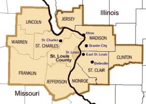
The St. Louis area is a big place! It's called a Metropolitan Statistical Area, and it's the 19th largest in the United States by population. In 2008, about 2.8 million people lived here.
This large area includes the independent City of St. Louis and many surrounding counties. These include St. Louis County, Saint Charles County, Jefferson County, Franklin County, Lincoln County, and Warren County in Missouri. It also includes counties in Illinois, like Madison County, Saint Clair County, Macoupin County, Clinton County, Monroe County, Jersey County, Bond County, and Calhoun County.
City Neighborhoods and Landmarks
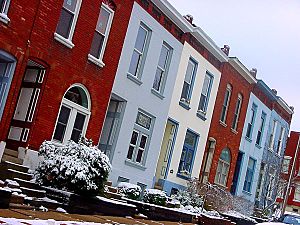
St. Louis is divided into 79 different neighborhoods. Even though these divisions aren't official laws, they are very important to the people who live there. Many neighborhoods have a strong sense of community.
Some neighborhoods have huge stone buildings that were built like palaces for important visitors during the 1904 World's Fair. Others have cozy homes for working families, or areas with old factories turned into apartments. Some parts of the city have faced challenges like unemployment. But in many neighborhoods, people really stick together and feel like they belong.
Some of the most famous or beautiful neighborhoods include Downtown, Midtown, Benton Park, Carondelet, the Central West End, Clayton/Tamm (also called Dogtown), Dutchtown South, Forest Park Southeast, Grand Center, The Hill, Lafayette Square, Shaw (where the famous Missouri Botanical Garden is located), Southwest Garden, Soulard, Tower Grove East, Tower Grove South, Hortense Place, and Wydown/Skinker.
St. Louis Weather and Seasons
| Weather chart for St. Louis | |||||||||||||||||||||||||||||||||||||||||||||||
|---|---|---|---|---|---|---|---|---|---|---|---|---|---|---|---|---|---|---|---|---|---|---|---|---|---|---|---|---|---|---|---|---|---|---|---|---|---|---|---|---|---|---|---|---|---|---|---|
| J | F | M | A | M | J | J | A | S | O | N | D | ||||||||||||||||||||||||||||||||||||
|
2.4
40
24
|
2.2
45
28
|
3.3
56
37
|
3.7
67
47
|
4.7
76
57
|
4.3
85
67
|
4.1
89
71
|
3
88
69
|
3.1
80
61
|
3.3
68
49
|
3.9
56
38
|
2.8
42
27
|
||||||||||||||||||||||||||||||||||||
| temperatures in °F precipitation totals in inches source: "NWS St. Louis, MO (LSX)" |
|||||||||||||||||||||||||||||||||||||||||||||||
|
Metric conversion
|
|||||||||||||||||||||||||||||||||||||||||||||||
St. Louis has a mix of two main climate types: a humid continental climate and a humid subtropical climate. This means it gets both cold air from the Arctic and warm, humid air from the Gulf of Mexico. There are no big mountains or large bodies of water nearby to make the temperatures more mild.
The city experiences four clear seasons. Spring is the wettest time of year and can bring strong storms, including tornadoes and even late winter storms. Summers are hot and humid, with temperatures often reaching 90°F or higher for about 43 days each year. This usually happens between May and September.
Fall is usually mild with less humidity. The first frost of the year typically happens around November 2nd. The first measurable snow usually falls around December 4th. Winters can be cold and snowy, with temperatures often below freezing. Winter storms can bring freezing rain, ice, and heavy snowfall.
The average yearly temperature in St. Louis is about 57.1°F. The city gets about 41 inches of rain each year. In July, the average daily temperature is 80.0°F, while in January, it's 31.8°F. Temperatures can reach over 100°F or drop below 0°F a few days each year. The coldest temperature ever recorded was -22°F in 1884, and the hottest was 115°F in 1954.
Winter (December to February) is the driest season, with about 7.5 inches of rain and snow. The city usually gets about 18.2 inches of snow each winter. The most snow in one day was 12.8 inches in 1906. Spring (March to May) is the wettest season, with about 11.7 inches of rain. The most rain in 24 hours was 6.85 inches in 1915. Sometimes, there are dry periods for one or two weeks during the growing seasons.
St. Louis has thunderstorms about 48 days a year. In spring, these storms can be very strong, with high winds, large hail, and tornadoes. St. Louis is in an area known as Tornado Alley, so it has a history of damaging tornadoes. Heavy flooding, like the Great Flood of 1993, can happen in spring and summer, especially when a lot of snow melts upstream in the Missouri or Mississippi Rivers.
Sometimes, late autumn brings warm weather, known as Indian summer. Some years, you can even see roses blooming as late as early December!
| Climate data for St. Louis, Missouri (Lambert–St. Louis Int'l), 1981−2010 normals, extremes 1874−present | |||||||||||||
|---|---|---|---|---|---|---|---|---|---|---|---|---|---|
| Month | Jan | Feb | Mar | Apr | May | Jun | Jul | Aug | Sep | Oct | Nov | Dec | Year |
| Record high °F (°C) | 77 (25) |
85 (29) |
92 (33) |
93 (34) |
98 (37) |
108 (42) |
115 (46) |
110 (43) |
104 (40) |
94 (34) |
86 (30) |
76 (24) |
115 (46) |
| Mean maximum °F (°C) | 64.1 (17.8) |
69.8 (21.0) |
80.2 (26.8) |
86.7 (30.4) |
89.4 (31.9) |
94.8 (34.9) |
98.5 (36.9) |
99.3 (37.4) |
92.7 (33.7) |
85.7 (29.8) |
75.6 (24.2) |
65.0 (18.3) |
100.4 (38.0) |
| Mean daily maximum °F (°C) | 39.9 (4.4) |
45.0 (7.2) |
55.9 (13.3) |
67.4 (19.7) |
76.3 (24.6) |
85.1 (29.5) |
89.1 (31.7) |
87.9 (31.1) |
80.2 (26.8) |
68.5 (20.3) |
55.5 (13.1) |
42.5 (5.8) |
66.2 (19.0) |
| Daily mean °F (°C) | 31.8 (−0.1) |
36.3 (2.4) |
46.3 (7.9) |
57.3 (14.1) |
66.8 (19.3) |
75.9 (24.4) |
80.0 (26.7) |
78.6 (25.9) |
70.4 (21.3) |
58.7 (14.8) |
46.8 (8.2) |
34.7 (1.5) |
57.0 (13.9) |
| Mean daily minimum °F (°C) | 23.7 (−4.6) |
27.6 (−2.4) |
36.6 (2.6) |
47.2 (8.4) |
57.2 (14.0) |
66.8 (19.3) |
71.0 (21.7) |
69.4 (20.8) |
60.6 (15.9) |
49.0 (9.4) |
38.1 (3.4) |
26.9 (−2.8) |
47.9 (8.8) |
| Mean minimum °F (°C) | 4.2 (−15.4) |
8.0 (−13.3) |
18.4 (−7.6) |
31.5 (−0.3) |
43.2 (6.2) |
54.3 (12.4) |
60.3 (15.7) |
59.0 (15.0) |
44.8 (7.1) |
33.5 (0.8) |
22.4 (−5.3) |
7.5 (−13.6) |
−1.8 (−18.8) |
| Record low °F (°C) | −22 (−30) |
−18 (−28) |
−5 (−21) |
20 (−7) |
31 (−1) |
43 (6) |
51 (11) |
47 (8) |
32 (0) |
21 (−6) |
1 (−17) |
−16 (−27) |
−22 (−30) |
| Average precipitation inches (mm) | 2.40 (61) |
2.24 (57) |
3.32 (84) |
3.69 (94) |
4.72 (120) |
4.28 (109) |
4.11 (104) |
2.99 (76) |
3.13 (80) |
3.33 (85) |
3.91 (99) |
2.84 (72) |
40.96 (1,040) |
| Average snowfall inches (cm) | 5.6 (14) |
4.3 (11) |
2.3 (5.8) |
0.4 (1.0) |
0 (0) |
0 (0) |
0 (0) |
0 (0) |
0 (0) |
0 (0) |
0.7 (1.8) |
4.4 (11) |
17.7 (45) |
| Average precipitation days (≥ 0.01 in) | 8.9 | 8.0 | 10.3 | 11.3 | 11.9 | 10.0 | 8.9 | 8.2 | 7.4 | 8.7 | 9.6 | 9.4 | 112.6 |
| Average snowy days (≥ 0.1 in) | 4.7 | 3.4 | 1.7 | 0.3 | 0 | 0 | 0 | 0 | 0 | 0 | 0.7 | 3.7 | 14.5 |
| Average relative humidity (%) | 73.0 | 72.0 | 68.3 | 63.5 | 66.5 | 67.1 | 68.0 | 70.0 | 71.6 | 68.7 | 72.2 | 75.8 | 69.7 |
| Mean monthly sunshine hours | 161.2 | 158.3 | 198.3 | 223.5 | 266.5 | 291.9 | 308.9 | 269.8 | 236.1 | 208.4 | 140.9 | 129.9 | 2,593.7 |
| Percent possible sunshine | 53 | 53 | 53 | 56 | 60 | 66 | 68 | 64 | 63 | 60 | 47 | 44 | 58 |
| Source: NOAA (relative humidity and sun 1961−1990) | |||||||||||||
Plants and Animals of St. Louis
Before St. Louis was built, the area was covered in open forests and grasslands. Native Americans used to burn parts of the land to keep it open. The main trees you'll see are oak, maple, and hickory, similar to the nearby Ozarks region. Smaller trees like eastern redbud, serviceberry, and flowering dogwood are also common. Along the rivers, you'll find mostly American sycamore trees. Many homes in the city have large native shade trees planted around them. The biggest natural forest area is in Forest Park. In the fall, the changing colors of the leaves are beautiful.
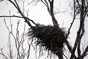
You might spot large animals like coyotes in the city, and sometimes even a whitetail deer. Smaller animals like eastern gray squirrels, cottontail rabbits, and opossums are very common. Many large birds live in the parks, including Canada geese, mallard ducks, and shorebirds like the great egret and great blue heron. Gulls are often seen along the Mississippi River, usually following barges. In winter, you can find bald eagles near the Mississippi River around the Chain of Rocks Bridge. St. Louis is on the Mississippi Flyway, which is a path many birds use when they migrate. This means you'll see a wide variety of small birds here. The Eurasian tree sparrow, a bird from Europe, is mostly found in North America only around St. Louis. Tower Grove Park is a great spot for birdwatching in the city.
Frogs are common in the spring, especially after a lot of rain. You might hear American toads and small chorus frogs, often called "spring peepers," in almost every pond. Some years, there are many cicadas or ladybugs. Mosquitoes and houseflies can be annoying insects. Because of this, most windows have screens, and many homes have "screened-in" porches. The number of honey bees has gone down recently, but other insects that help plants grow have taken their place.
Communities Near St. Louis
The City of St. Louis is bordered by many other communities. Here are some of them:
- Cahokia, Illinois
- East Carondelet, Illinois
- East St. Louis, Illinois
- Madison, Illinois
- Sauget, Illinois
- Bellefontaine Neighbors, Missouri
- Clayton, Missouri
- Glasgow Village, Missouri
- Hillsdale, Missouri
- Jennings, Missouri
- Lemay, Missouri
- Mackenzie, Missouri
- Maplewood, Missouri
- Pine Lawn, Missouri
- Richmond Heights, Missouri
- Riverview, Missouri
- Shrewsbury, Missouri
- Spanish Lake, Missouri
- University City, Missouri
- Wellston, Missouri
Also, parts of Madison County, Illinois, St. Clair County, Illinois, and St. Louis County, Missouri that aren't officially towns or cities also border St. Louis. The Illinois towns of Brooklyn and Venice are across the Mississippi River, but they don't directly touch St. Louis because the river itself isn't part of their land.


