
Rhine facts for kids
Quick facts for kids Rhine |
|
|---|---|

The Lorelei rock in Rhineland-Palatinate
|
|

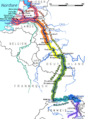
Map of the Rhine basin
|
|
| Native name | Rhenus, Rein, Rhein, le Rhin, Rijn |
| Country | Switzerland, Liechtenstein, Austria, Germany, France, Netherlands |
| Rhine Basin | Switzerland, Liechtenstein, Vorarlberg, South and Western Germany, North-Eastern France, Luxembourg, Belgium, Netherlands, Val di Lei, Italy |
| Region | Central and Western Europe |
| Physical characteristics | |
| Main source | Rein Anteriur/Vorderrhein Tomasee (Romansh: Lai da Tuma), Surselva, Graubünden, Switzerland 2,345 m (7,694 ft) 46°37′57″N 8°40′20″E / 46.63250°N 8.67222°E |
| 2nd source | Rein Posteriur/Hinterrhein Paradies Glacier, Graubünden, Switzerland |
| River mouth | North Sea Netherlands 0 m (0 ft) 51°58′54″N 4°4′50″E / 51.98167°N 4.08056°E |
| Length | 1,230 km (760 mi), |
| Basin features | |
| Basin size | 185,000 km2 (71,000 sq mi) |
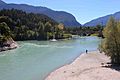
The Rhine is one of Europe's most important rivers. It starts in the Swiss Alps and flows mostly north through Germany and the Netherlands. Finally, it empties into the North Sea. The river begins in the canton of Graubünden in southeastern Switzerland. It forms parts of the borders between Switzerland and Liechtenstein, Austria, and Germany. Later, it forms part of the border between France and Germany. After that, it flows through the German Rhineland and the Netherlands.
Cologne, Germany, is the largest city on the Rhine. More than 1,050,000 people live there. The Rhine is the second-longest river in Central and Western Europe, after the Danube. It is about 1,230 km (760 mi) long. On average, it carries about 2,900 m3/s (100,000 cu ft/s) of water.
Long ago, the Rhine and the Danube rivers marked most of the northern border of the Roman Empire. Since then, the Rhine has been a very important waterway. It has carried trade and goods deep into the land for centuries. Many castles and forts were built along its banks. This shows how important it was for trade in the Holy Roman Empire. Today, it is a symbol for German nationalism.
Some of the biggest and most important cities on the Rhine are Cologne, Düsseldorf, Rotterdam, Strasbourg, and Basel.
Contents
Exploring the Rhine River
How Long is the Rhine?
For a long time, people thought the Rhine was 1,230 km (760 mi) long. In 1932, a German encyclopedia mistakenly said it was 1,300 km (810 mi). This error was copied into many books. In 2010, the mistake was found. The correct length is about 1,233 km (766 mi).
Rhine's Journey Through Countries
The Rhine gets its name where two smaller rivers, the Vorderrhein and Hinterrhein, meet. This happens near Reichenau in Switzerland.
The Vorderrhein starts from Lai da Tuma (Tomasee). This lake is near the Oberalp Pass. The river then flows through the amazing Ruinaulta canyon. This canyon was formed by a huge rockslide. You can hike along the young Rhine on a trail called Senda Sursilvana.
The Hinterrhein begins at the Paradies Glacier. One of its smaller rivers, the Reno di Lei, flows from Italy. After passing through two deep gorges, Roflaschlucht and Viamala, it joins the Vorderrhein at Reichenau.
The Alpine Rhine Section
From Reichenau, the Rhine flows east. This part is called the Alpenrhein or "Alpine Rhine". It passes Chur and then turns north. For about 20 km, it forms the border between Liechtenstein and Austria on one side, and St. Gallen, Switzerland, on the other.
The river then flows into Lake Constance. It comes out of Lake Constance and flows west as the Hochrhein. It passes the famous Rhine Falls. The Aar river joins it, more than doubling the Rhine's water flow. The Aar also brings water from Finsteraarhorn, the highest point in the Rhine's river basin. The Rhine forms the border with Germany from Lake Constance until it turns north at Basel, leaving Switzerland.
Rhine in Germany and France
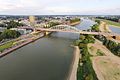
The Rhine is the longest river in Germany. Here, it meets some of its biggest tributaries. These include the Neckar, the Main, and later, the Moselle. The Moselle adds a lot of water to the Rhine. Most of Luxembourg and a small part of Belgium also drain into the Rhine through the Moselle. Near the Dutch border, the Rhine is about 400 m (1,300 ft) wide.
Between Bingen and Bonn, the Middle Rhine flows through the Rhine Gorge. This gorge was carved by the river over time. It is known for its many castles and vineyards. This area is a UNESCO World Heritage Site and is called "the Romantic Rhine". It has over 40 castles from the Middle Ages and charming villages.
In the past, factories caused a lot of water pollution in the Rhine. Now, the river is much cleaner. This is thanks to stricter rules and changes in industries. The Ruhr river, which joins the Rhine in Duisburg, is now clean enough for drinking water. Duisburg has Europe's largest inland port. It connects to sea ports like Rotterdam.
Rhine in the Netherlands
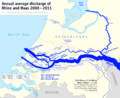
In the Netherlands, the Rhine turns west. Here, it forms a large river delta with the Meuse and Scheldt rivers. This is one of the biggest deltas in Western Europe. The Rhine enters the Netherlands near Spijk. It then splits into three main branches: the Waal River, Nederrijn ("Lower Rhine"), and IJssel.
Most of the Rhine's water flows through the Waal. It then goes through other channels like the Merwede and Nieuwe Merwede. Finally, it merges with the Meuse and flows into the North Sea. Other parts of the river flow through the Pannerdens Kanaal. They then split into the IJssel and Nederrijn. The IJssel flows north into the IJsselmeer. The Nederrijn flows west and changes its name to the Lek. It eventually joins other rivers to reach the North Sea.
Some smaller streams in the north still carry the name "Rhine" (Rijn). However, they no longer carry water from the main Rhine. They are used to drain the surrounding land. One of these, the Oude Rijn ("Old Rhine"), once formed the border for the Roman Empire.
Major Cities Along the Rhine
Many important cities are located along the Rhine. These include:
- Basel
- Strasbourg
- Karlsruhe
- Mannheim
- Ludwigshafen
- Wiesbaden
- Mainz
- Koblenz
- Bonn
- Cologne
- Düsseldorf
- Neuss
- Duisburg
- Arnhem (on the Nederrijn branch)
- Nijmegen (on the Waal branch)
- Utrecht (on the Kromme Rijn branch)
- Rotterdam (on the Nieuwe Maas branch)
Sections of the Rhine River
The Rhine's path can be divided into several parts:
- The headwaters, where the river begins.
- The Alpine Rhine, from Tamins-Reichenau to Lake Constance.
- Lake Constance itself.
- The High Rhine, from Lake Constance to Basel.
- The Upper Rhine, from Basel to Bingen am Rhein.
- The Middle Rhine, from Bingen am Rhein to Bonn.
- The Lower Rhine, from Bonn to the North Sea.
- The Rhine-Meuse-Scheldt delta, where it meets the sea.
Headwaters of the Rhine


The Rhine gets its name when the Vorderrhein and Hinterrhein join near Tamins-Reichenau. Before this point, there are many smaller streams that feed into the Rhine. Most of these are in the Canton of Grisons, Switzerland.
Traditionally, Lake Toma near the Oberalp Pass is seen as the main source of the Vorderrhein and the entire Rhine. The Hinterrhein starts in the Rheinwald valley.
Vorderrhein
The Vorderrhein (meaning Anterior Rhine) starts from many streams in the upper Surselva region. It flows east. One source is Lai da Tuma (Lake Toma) at 2345 meters high. This is usually named as the Rhine's source.
Many other streams flow into it from the south. Some of these are the Reno di Medel and the Rein da Curnera. Many streams in this area are used to fill reservoirs for hydroelectric power plants.
Lower down, the Vorderrhein flows through a gorge called Ruinaulta. This gorge was formed by the Flims Rockslide. There's a long hiking trail called Senda Sursilvana along this part of the river.
Hinterrhein

The Hinterrhein (meaning Posterior Rhine) flows first east, then north. It goes through three valleys: Rheinwald, Schams, and Domleschg-Heinzenberg. Deep gorges like the Roffla Gorge and Viamala Gorge separate these valleys. Its sources are in the Adula Alps.
The Avers Rhine joins it from the south. Its headwaters, like the Reno di Lei, are partly in Italy. Near Sils, the Hinterrhein is joined by the Albula river.
Many "Rhines"

Many smaller rivers and streams in the area are also called "Rhine" or similar names like Rein or Ragn. For example:
- Vorderrhein area: Rein da Medel, Rein da Tuma, Vals Rhine.
- Hinterrhein basin: Reno di Lei, Avers Rhein.
- Albula-Landwasser area: There's a place called Am Rin ("Upon Rhine") and a mountain called Rinerhorn.
Alpine Rhine

Near Tamins-Reichenau, the Anterior Rhine and Posterior Rhine meet. They form the Alpine Rhine. This part of the river is about 86 km long. It flows through a wide valley called the Rhine Valley. Near Sargans, a small natural dam stops it from flowing into the Seeztal valley.
The Alpine Rhine starts in the middle of the Swiss canton of Grisons. Later, it forms the border between Switzerland and Liechtenstein, and then Austria. It flows into Lake Constance. The mouth of the Rhine into Lake Constance forms a delta. This delta is mostly a nature reserve and bird sanctuary.

People built canals to control the Rhine's flow and stop floods. The "Old Rhine" area became a swamp. Later, a canal was dug to make it navigable to Rheineck.
Lake Constance


Lake Constance is made of three parts: the Obersee ("upper lake"), the Untersee ("lower lake"), and the Seerhein that connects them. The lake is in Germany, Switzerland, and Austria. The Rhine flows into it from the south.
Obersee
Cold, gray mountain water from the Rhine flows into the Obersee. This cold water stays near the surface at first. Then, it suddenly sinks because it's denser than the warmer lake water. The water reappears on the northern (German) shore, near Lindau.
The Rhine carries a lot of sand and gravel into the lake. This means that people have to constantly remove gravel by dredging. Three countries border the Obersee: Switzerland, Austria, and the German states of Bavaria and Baden-Württemberg.


The Seerhein is only four km long. It connects the Obersee with the Untersee, which is 30 cm lower. Distance markers along the Rhine start from the bridge in Constance. Most of the Seerhein forms the border between Germany and Switzerland.
Untersee
The Rhine's flow can also be seen in the Untersee. The river water doesn't mix much with the lake water here either. Reichenau Island was formed when the lake's water level dropped. Lake Untersee is part of the border between Switzerland and Germany.
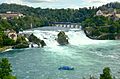
High Rhine


The High Rhine starts at Stein am Rhein at the western end of the Untersee. It flows west, unlike the Alpine Rhine. It drops from 395 m to 252 m in height.
Some parts of the High Rhine form the border between Switzerland and Germany. Other parts are entirely in Switzerland, like most of the Canton of Schaffhausen. Between Eglisau and Basel, the High Rhine always forms the border.
The Rhine Falls are below Schaffhausen. They have a large water flow and are the second-largest waterfall in Europe in terms of power. The High Rhine has many dams. In its natural sections, there are still some rapids.
Near Koblenz, the Aar river joins the Rhine. The Aar carries more water than the Rhine at this point. However, the Alpine Rhine is still considered the main river because it is longer.
Upper Rhine

In Basel, the Rhine makes a big bend called the "Rhine knee". Here, its direction changes from west to north. This is where the High Rhine ends. The river then flows north as the Upper Rhine. It goes through the Upper Rhine Plain, which is about 300 km long. Important rivers like the Ill, Neckar, and Main join it here. In Mainz, the Rhine leaves the Upper Rhine Valley.
The southern part of the Upper Rhine forms the border between France (Alsace) and Germany (Baden-Württemberg). The northern part forms the border between the German states of Rhineland-Palatinate and Baden-Württemberg/Hesse.
The Upper Rhine area has been important for a long time. Today, it has many factories and businesses. Strasbourg, where the European Parliament is located, is on the Upper Rhine.
The Upper Rhine was changed a lot in the 19th century to make it straighter. This made the water flow faster and lowered the groundwater. On the French side, the Grand Canal d'Alsace was dug. This canal carries a lot of the river's water and all the boat traffic.
Middle Rhine

The Middle Rhine flows through the Rhine Gorge. This section of the river drops from 77.4 m to 504 m above sea level. On one side are the Hunsrück and Eifel mountains. On the other side are the Taunus and Westerwald mountains. Geologists believe the river carved this narrow valley as the land around it rose.
Major rivers joining the Rhine here are the Lahn and the Moselle. They meet the Rhine near Koblenz. Most of the Middle Rhine is in the German state of Rhineland-Palatinate.
The main industries in the Middle Rhine area are making wine and tourism. The Rhine Gorge between Rüdesheim am Rhein and Koblenz is a World Heritage Site. Near Sankt Goarshausen, the Rhine flows around the famous Lorelei rock. This area is known for its beautiful castles, vineyards, and charming villages.
Lower Rhine


In Bonn, the Rhine enters the North German Plain and becomes the Lower Rhine. This part of the river drops from 50 m to 12 m. The main rivers joining it here are the Ruhr and the Lippe. Like the Upper Rhine, the Lower Rhine was straightened by engineers.
The Lower Rhine flows through North Rhine-Westphalia. Its banks are very populated and industrial. This includes big cities like Cologne, Düsseldorf, and the Ruhr Area. Duisburg has Europe's largest river port. The area downstream from Duisburg is more agricultural. The Emmerich Rhine Bridge, Germany's longest suspension bridge, crosses the Rhine near Emmerich.
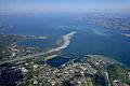
Rhine-Meuse Delta

The Rhine-Meuse-Scheldt delta is the most important natural area in the Netherlands. It starts near Millingen aan de Rijn, where the Rhine splits into the Waal and Nederrijn. Since the Rhine provides most of the water, it's often called the Rhine Delta.
The shape of the delta is formed by two splits in the river. First, the Rhine splits into the Waal and Nederrijn. Second, the IJssel branches off from the Nederrijn. This creates three main flows. The largest flow starts as the Waal and eventually reaches the North Sea near Rotterdam. The middle flow starts as the Nederrijn and also reaches the North Sea. The northern flow, the IJssel, goes north into the IJsselmeer.

Before a big flood in 1421, the Meuse river flowed south of today's path. It formed many islands and changed its coastline often. Later, the Meuse was separated from the Waal to prevent floods.
Today, the delta has many river branches and smaller streams. Many rivers have been dammed and now drain the surrounding polders (low-lying land). The construction of the Delta Works changed the delta a lot in the 20th century. Now, Rhine water flows into the sea at five different places.
The Rhine-Meuse Delta is a tidal delta. This means it's shaped by both river sediments and ocean tides. Before the Delta Works, tides could be felt far inland. Even now, tides affect the river far from the sea.
Tributaries of the Rhine
Rivers that flow into the Rhine, from where the Rhine starts to where it ends:
|
Left side: |
Right side: |
Canals Connected to the Rhine
Canals that connect to the Rhine, from upstream to downstream:
- Rhine–Main–Danube Canal – in southeastern Germany
- Grand Canal d'Alsace – in eastern France
- Rhine-Herne Canal – in northwest Germany, connects to other canals
- Maas-Waal Canal – in east-central Netherlands
- Amsterdam-Rhine Canal – in central Netherlands
- Scheldt-Rhine Canal – in southwest Netherlands
- Canal of Drusus
How the Rhine Changed Over Time
Geological History
The Rhine flows from the Alps to the North Sea. Its path and the land around it have changed over millions of years. This happened because of how the Earth's tectonic plates moved.
Millions of years ago, the Alps formed when the African and Eurasian plates pushed together. At the same time, the North Sea Basin was forming in northern Europe. Between these two areas, older mountains like the Ardennes and Vosges remained.
Around 50 million years ago, a rift system (a crack in the Earth's crust) began to form. This created the Upper Rhine Graben and the Lower Rhine Embayment. The first Rhine river started in the Upper Rhine Graben. Back then, it didn't get water from the Alps. Other rivers like the Rhone and Danube drained the Alps.
River Changes and Ice Ages
Over time, the Rhine "captured" other river systems. This means it took over their water flow. By about 5 million years ago, the Rhine had extended its reach south to the Vosges Mountains. It also gained rivers like the Moselle, Main, and Neckar. Later, it captured most of its current Alpine water from the Rhône, including the Aar.
About 2.5 million years ago, the Earth entered a period of Ice Ages. During these times, sea levels dropped a lot. The Rhine's path changed. It flowed through what is now the North Sea and even the English Channel. Rivers like the Thames and the Seine became tributaries of the Rhine.
During the last Ice Age, much of the Rhine's path was not covered by ice. A cold, treeless land called tundra stretched across central Europe. Wind-blown dust from this tundra settled in the Rhine Valley, making its soil good for farming today.
After the Last Ice Age
Around 22,000 years ago, Europe began to warm up. Glaciers melted, and snow covers thawed. This added a lot of water to the Rhine. Forests grew back across Europe. As sea levels rose, the English Channel and North Sea filled with water again.
About 11,000 years ago, the Rhine's mouth was in the Dover Strait. Some dry land still connected Europe to Britain. But about 9,000 years ago, this land bridge was covered by the sea.
Since about 7,500 years ago, the Rhine's tides and currents have been similar to today. The sea level rise slowed down. The river's natural sediments and coastal changes could keep up with the rising sea.
Historical Importance of the Rhine

The history of the Rhine is often told by Roman writers. The Romans called it Rhenus. They saw the Rhine as the edge of their civilized world. Beyond it were wild Germanic tribes.
The Romans stationed many soldiers along the Rhine. They had two army groups: "lower" (downstream) and "upper" (upstream). These areas became known as Lower Germania and Upper Germania. The Romans kept eight legions (large army units) in five bases along the Rhine.
The first city on the Rhine that is now Cologne was founded in 38 BC by a Germanic tribe called the Ubii. The Romans recognized it as a city in AD 50. Today, you can still find Roman remains in Cologne, especially near the river.
Over time, different languages developed along the Rhine. After the death of Charlemagne, his empire split. The Rhine became a political border again.
The Rhine has always been a symbol, both mystical and political. German writers and composers have written many works about it. During World War II, it was still seen as a sacred border and a defensive barrier for Germany.
Images for kids
-
Map of the Rhine (for interactive map click here: )
-
The confluence of the Anterior Rhine to the lower left and the Posterior Rhine in the back, forming the Alpine Rhine to the left next to Reichenau
-
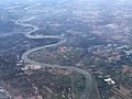
Aerial image of the mouth of the Rhine into Lake Constance
-
The Rhine Fall at Schaffhausen (Switzerland)
-
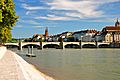
The Rhine in Basel is Switzerland's gateway to the sea
-
The Rhine at Mannheim, in the Rhine-Neckar industrial area
-
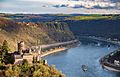
View of the Middle Rhine Valley and Burg Katz, in the background Lorelei
-
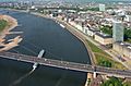
Low water in Düsseldorf
-
Map showing how the waters of the Rhine and Meuse rivers split into various branches of their combined delta
-
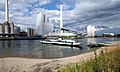
The Nederrijn at Arnhem
-
Castellum Nigrum Pullum, Zwammerdam, The Netherlands, artist impression Stevie Xinas
-
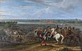
French forces under Louis XIV cross the Rhine into the Netherlands in 1672
-
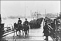
Allied soldiers of the Royal Newfoundland Regiment crossing the Rhine into Germany after the end of WWI, December 1918
-
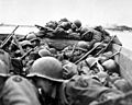
Soldiers of the US 89th Infantry Division cross the Rhine in assault boats under German fire as part of Operation Plunder on 24 March 1945
-
Rhine at Hünxe, near the border of the Netherlands


.png)


.jpg)


See also
 In Spanish: Rin para niños
