
Midlands facts for kids
Quick facts for kids
The Midlands
|
|
|---|---|
 The Midlands region shown in England |
|
| Sovereign state | |
| Constituent country | |
| Major cities | Birmingham Coventry Derby Leicester Lincoln Nottingham Stoke Wolverhampton Worcester |
| Principal settlements |
A 'Metro' cities
B Other 'cities' A1. W Midlands Urban Area (Birmingham, Wolv'n) B2. Northampton B3. Telford B4. Chesterfield B5. Worcester B6. Lincoln B7. Shrewsbury B8. Hereford B9. Stafford B10. Warwick B11. Oakham |
| Area | |
| • Total | 28,627 km2 (11,053 sq mi) |
| Highest elevation | 703.6 m (2,308 ft) |
| Population
(2021 census)
|
|
| • Total | 10,831,000 |
| • Density | 378.349/km2 (979.91/sq mi) |
| Demonym(s) | Midlander, Mercian |
| Time zone | UTC+0 (Greenwich Mean Time) |
| • Summer (DST) | UTC+1 (British Summer Time) |
The Midlands is the central part of England. It is bordered by Wales to the west. To the north is Northern England, and to the south is Southern England. The North Sea is to the east.
This area was once the ancient kingdom of Mercia. It became very important during the Industrial Revolution in the 1700s and 1800s. Today, the Midlands is divided into two official regions: the West Midlands and the East Midlands.
Birmingham is the biggest city in the Midlands. It is also the second-largest city in the entire United Kingdom. Other important cities here include Coventry, Derby, Leicester, Lincoln, Nottingham, Stoke-on-Trent, Wolverhampton, and Worcester.
Contents
What Does the Midlands Flag Mean?
The Midlands has a special flag. It shows a saltire, which is a diagonal cross. This symbol might have been used by the ancient kingdom of Mercia a long time ago.
By the 1200s, this diagonal cross became the official symbol of Mercia. The flag has a gold (or yellow) saltire on a blue background. You can see this flag flying at Tamworth Castle. This castle was once the home of the Mercian kings.
.svg)
The Mercian flag is also on signs that welcome people to Tamworth. This town is known as the "ancient capital of Mercia." The flag was even flown outside Birmingham Council House in 2009. This was when the Staffordshire Hoard (a famous treasure) was on display there. Many towns in the Midlands, like Tamworth, Leek, and Blaby, have this cross in their official symbols. The Flag Institute officially recognized it as the Mercian flag in 2014.
Where Exactly is the Midlands?
There isn't just one way to define the Midlands. Usually, it includes the official regions of the East Midlands and West Midlands. This covers counties like Derbyshire, Herefordshire, Leicestershire, and most of Lincolnshire. It also includes Northamptonshire, Nottinghamshire, Rutland, Shropshire, Staffordshire, Warwickshire, and Worcestershire.
Sometimes, other areas are also seen as part of the Midlands. For example, parts of Gloucestershire and Bedfordshire have been called "Midland" counties. The term "Central England" is often used to mean the same thing as "the Midlands."
There are also informal areas called the South Midlands and North Midlands. The South Midlands includes the southern parts of the East Midlands. The North Midlands covers the northern parts of the West and East Midlands.
How the Midlands is Divided
The Midlands is split into two main regions: the West Midlands and the East Midlands. These are important for how local government works.

Many large towns and cities in the Midlands are run by special councils called Boroughs or Unitary Authorities. These include:
Other areas are divided into counties. These counties then have smaller districts within them. Some of these counties are:
- Derbyshire
- Herefordshire
- Leicestershire
- Lincolnshire
- Northamptonshire
- Nottinghamshire
- Rutland
- Shropshire
- Staffordshire
- Warwickshire
- Worcestershire
The two Midlands regions together have a population of over 10 million people. They cover an area of about 28,627 square kilometers (11,053 square miles).
The biggest urban area in the Midlands includes Birmingham and Wolverhampton. This area is often called the West Midlands metropolitan county. It also includes Coventry. This large urban area extends into nearby parts of Shropshire, Staffordshire, Warwickshire, and Worcestershire.
Some parts of the Midlands, like Warwickshire and Leicestershire, are sometimes called the "Heart of England." This is especially true in tourist guides. This is because the geographic center of England is thought to be in this area.
Different parts of the Midlands have their own unique feel. For example, Nottingham played a big role in the English Civil War. Areas like Derbyshire's Amber Valley have beautiful countryside and old industrial sites. The Black Country, which includes towns like Dudley, Sandwell, Wolverhampton, and Walsall, was very important during the Industrial Revolution.
Historic Counties of the Midlands
The Midlands also has historic counties. These were used for administrative purposes until 1899. However, they are still important to some people, for example, in county cricket.
Geography of the Midlands
The Midlands is mostly flat and low. But there are some isolated hills. Turners Hill in the Black Country is 271 meters (889 feet) high. The Wrekin near Telford is 407 meters (1,335 feet) high.
Higher areas are found in the west and north. The Shropshire Hills are in the west, near the England–Wales border. The Peak District is in the north. The Shropshire Hills reach 540 meters (1,771 feet) at Brown Clee Hill. This area includes the Long Mynd, Clee Hills, and Stiperstones ridge. Wenlock Edge is a long, low ridge that stretches for over 24 kilometers (15 miles).
The Peak District has hills between 300 meters (1,000 feet) and 600 meters (2,000 feet) high. Kinder Scout is the highest point at 636 meters (2,086 feet). Further south, near the Welsh border, Twyn Llech is 703 meters (2,306 feet) high. This is the highest point in Herefordshire.
The Malvern Hills are made of some of England's oldest rocks. They are about 680 million years old! These hills stretch for about 13 kilometers (8 miles). They go through Worcestershire and Herefordshire, and also into northern Gloucestershire. The highest point is the Worcestershire Beacon at 425 meters (1,394 feet).
The Cotswolds are another beautiful area. They stretch for over 145 kilometers (90 miles). They go through several counties, including Warwickshire and Worcestershire. The highest point here is Cleeve Hill at 330 meters (1,082 feet).
Other lower hills, between 200 meters (600 feet) and 300 meters (1,000 feet), include Charnwood Forest in Leicestershire. There is also Cannock Chase in Staffordshire. The Lincolnshire Wolds are between 100 meters (300 feet) and 200 meters (600 feet) high. They stand out because Lincolnshire is mostly flat.
Lincolnshire is the only coastal county in the Midlands. The region is bordered by Wales to the west. The lowest points in the Midlands are also in Lincolnshire. Some places near Thorpe Tilney and Stickford are even below sea level.
Climate in the Midlands
The Midlands has a mild maritime climate. This means it has cool, cloudy, and wet winters. Summers are usually pleasant, mostly dry, and sunny.
Temperatures in winter nights are often around -0.4°C (31.3°F). In summer days, they can reach about 24.1°C (75.4°F). Because the Midlands is far from the coast, it usually has light winds. This also means it can have warm days and cold nights.
Sometimes, winter nights can be very cold. For example, it was -18.7°C (-1.7°F) in Pershore on December 20, 2010. Hot days are also possible. It reached 34°C (93.2°F) in Pershore on July 19, 2006.
The highest and lowest temperatures ever recorded in England both happened in the Midlands. On July 19, 2022, it reached 40.3°C (104.5°F) near Coningsby in Lincolnshire. On January 10, 1982, it dropped to -26.1°C (-15.0°F) near Newport in Shropshire.
| Climate data for Midlands | |||||||||||||
|---|---|---|---|---|---|---|---|---|---|---|---|---|---|
| Month | Jan | Feb | Mar | Apr | May | Jun | Jul | Aug | Sep | Oct | Nov | Dec | Year |
| Mean daily maximum °C (°F) | 6.7 (44.1) |
7 (45) |
9.7 (49.5) |
12.5 (54.5) |
15.9 (60.6) |
18.8 (65.8) |
21.1 (70.0) |
20.8 (69.4) |
17.8 (64.0) |
13.7 (56.7) |
9.6 (49.3) |
6.9 (44.4) |
13.4 (56.1) |
| Mean daily minimum °C (°F) | 1 (34) |
0.8 (33.4) |
2.4 (36.3) |
3.7 (38.7) |
6.5 (43.7) |
9.4 (48.9) |
11.5 (52.7) |
11.3 (52.3) |
9.3 (48.7) |
6.5 (43.7) |
3.5 (38.3) |
1.3 (34.3) |
5.6 (42.1) |
| Average rainfall mm (inches) | 74 (2.9) |
54 (2.1) |
58.8 (2.31) |
59.1 (2.33) |
58.5 (2.30) |
62.3 (2.45) |
60.8 (2.39) |
66.9 (2.63) |
66.2 (2.61) |
82 (3.2) |
77.1 (3.04) |
78.7 (3.10) |
798.4 (31.36) |
| Average rainy days (≥ 1 mm) | 12.9 | 10.2 | 11.5 | 10.6 | 10.2 | 9.7 | 9.4 | 10 | 9.7 | 12.2 | 12.5 | 12.4 | 131.3 |
| Mean monthly sunshine hours | 52.1 | 71.4 | 104.8 | 147 | 183.2 | 174.7 | 189.6 | 177.6 | 132.2 | 99.4 | 61.2 | 45 | 1,438.2 |
| Source: Met Office | |||||||||||||
Things Named After the Midlands
The name "Midland" has been used for several things:
- Midland Bank: A bank that started in Birmingham, now part of HSBC.
- Midland Metro: A tram system, now called West Midlands Metro.
- Midlands Engine: A UK government plan to help the region grow.
- Midland Main Line: A railway line from London through the East Midlands to Sheffield.
Images for kids
-
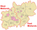
A map showing the different councils and regions within the Midlands.
-
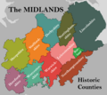
A map showing the historic counties of the Midlands.

See also
 In Spanish: Tierras Medias (Inglaterra) para niños
