
West Sussex facts for kids
Quick facts for kids
West Sussex
|
|||||||||||||||||||||||||||||||||||||||||||||||||||||
|---|---|---|---|---|---|---|---|---|---|---|---|---|---|---|---|---|---|---|---|---|---|---|---|---|---|---|---|---|---|---|---|---|---|---|---|---|---|---|---|---|---|---|---|---|---|---|---|---|---|---|---|---|---|
|
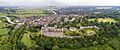
Arundel and its castle; Bognor Regis beach and pier; and the Old Punch Bowl pub in Crawley, a Wealden hall house
|
|||||||||||||||||||||||||||||||||||||||||||||||||||||
 |
|||||||||||||||||||||||||||||||||||||||||||||||||||||
| Sovereign state | United Kingdom | ||||||||||||||||||||||||||||||||||||||||||||||||||||
| Constituent country | England | ||||||||||||||||||||||||||||||||||||||||||||||||||||
| Region | South East England | ||||||||||||||||||||||||||||||||||||||||||||||||||||
| Established | 1974 | ||||||||||||||||||||||||||||||||||||||||||||||||||||
| Time zone | UTC±00:00 (Greenwich Mean Time) | ||||||||||||||||||||||||||||||||||||||||||||||||||||
| • Summer (DST) | UTC+01:00 (British Summer Time) | ||||||||||||||||||||||||||||||||||||||||||||||||||||
| Members of Parliament | 8 MPs | ||||||||||||||||||||||||||||||||||||||||||||||||||||
| Police | Sussex Police | ||||||||||||||||||||||||||||||||||||||||||||||||||||
|
|||||||||||||||||||||||||||||||||||||||||||||||||||||


.JPG)

West Sussex is a beautiful county in South East England. It's like a special area with its own traditions and history. To its north is Surrey, to the east is East Sussex, and to the west is Hampshire. The English Channel forms its southern border. The biggest town here is Crawley, but the main county town is the city of Chichester.
West Sussex covers about [convert: needs a number] of land. Around 764,300 people live here. Along the southern coast, there's a big urban area. This area includes towns like Bognor Regis, Littlehampton, and Worthing. The inland parts of the county are mostly rural, meaning they have more countryside. The largest towns in the north-east are Crawley and Horsham. Chichester is in the south-west. West Sussex has seven local government areas, all part of the larger West Sussex County Council. West Sussex and East Sussex used to be one big county called Sussex.
The South Downs are a very important part of the county. These hills stretch from east to west, dividing the northern and southern areas. The downs are made of chalk and drop steeply into the Weald to the north. To the south, the land slopes gently towards the coast. Here, a narrow flat strip of land lies between the hills and the sea. This coastal strip gets wider in the west. It has Chichester Harbour, which is a type of inlet called a ria.
West Sussex has a very long history. People have lived here since the Lower Paleolithic (Old Stone Age). The Romans took over the area. They made it a Roman province called Regni. Later, in the Early Middle Ages, the Saxons settled here. They created the Kingdom of Sussex in 477 AD. This kingdom lasted until about 827 AD when it became part of Wessex. The county is also home to many grand stately homes like Goodwood House, Petworth House, and Uppark. You can also find impressive castles such as Arundel Castle and Bramber Castle.
Contents
A Look Back: West Sussex History
The name Sussex comes from 'Sūþsēaxe', meaning 'South Saxons'. This name dates back to the Saxon period, from 477 AD to 1066 AD. However, people lived in Sussex much earlier, during the Old Stone Age. The oldest human remains found in Britain were discovered at Eartham Pit, Boxgrove. Over time, Sussex has seen many different groups of people arrive and settle.
Ancient Times and Roman Rule
Ancient monuments in West Sussex include the Devil's Jumps, Treyford. These are Bronze Age burial mounds. There are also Iron Age hill forts like Cissbury Ring and Chanctonbury Ring on the South Downs.
During the Roman period, important buildings were constructed. These include Fishbourne Roman Palace and country villas like Bignor Roman Villa. The Romans also built a network of roads, such as Stane Street (Chichester). They used the Weald area for making iron on a large scale.
Saxon Kingdom and County Formation
The start of the Kingdom of Sussex is mentioned in the Anglo-Saxon Chronicle for the year 477 AD. It says that Ælle arrived with his three sons and fought the local people. Most historians think this story is partly a myth. But archaeological finds show that Saxons did begin to settle here in the late 5th century. The Kingdom of Sussex later became part of Wessex. It then became known as the county of Sussex.
In 1888, Sussex was divided into two parts for administrative reasons: East and West Sussex. Then, in 1974, West Sussex became a single ceremonial county. This happened when the Local Government Act 1972 came into effect.
Towns and Villages in West Sussex

Most towns and villages in West Sussex are either along the south coast or in the middle of the county. Many are close to the M23/A23 roads. Crawley is the largest town, with an estimated population of 106,600. Worthing is close behind with 104,600 people.
Other large towns include the seaside resort of Bognor Regis and the market town of Horsham. Chichester, the county town, has a beautiful cathedral and is a city. It's located near the border with Hampshire.
Other towns of similar size are Burgess Hill, East Grinstead, and Haywards Heath in the Mid Sussex area. You'll also find Littlehampton in the Arun area. And Lancing, Southwick, and Shoreham are in the Adur area. Much of the population along the coast is part of the larger Brighton/Worthing/Littlehampton urban area.
Smaller towns in West Sussex include Arundel, Midhurst, Petworth, Selsey, and Steyning. Some larger villages are Billingshurst, Copthorne, Crawley Down, Cuckfield, Henfield, Hassocks, Hurstpierpoint, Lindfield, Pulborough, and Storrington. The total population of West Sussex makes up about 1.53% of England's population.
West Sussex Geography

Land and Rivers
West Sussex shares borders with Hampshire to the west, Surrey to the north, and East Sussex to the east. The English Channel is to the south. The land here was formed from ancient rock layers. The eastern part of this area, called the Weald, has been worn away over time. This has revealed older rocks beneath.
In West Sussex, the oldest rocks are found towards the north. These include ridges along the Surrey border. The highest point in the county, Blackdown, is in this area. The wearing away of softer sand and clay has created the Weald basin. This leaves a steep slope of chalk that runs across the county. This slope is only broken by the valleys of the River Arun and River Adur. These two rivers drain most of the county. There's also the River Lavant, which flows only at certain times of the year from springs north of Chichester.
West Sussex covers about 1.52% of England's total land. This makes it the 30th largest county in the country.
| Weather chart for Bognor Regis | |||||||||||||||||||||||||||||||||||||||||||||||
|---|---|---|---|---|---|---|---|---|---|---|---|---|---|---|---|---|---|---|---|---|---|---|---|---|---|---|---|---|---|---|---|---|---|---|---|---|---|---|---|---|---|---|---|---|---|---|---|
| J | F | M | A | M | J | J | A | S | O | N | D | ||||||||||||||||||||||||||||||||||||
|
76
8
3
|
50
8
3
|
56
10
4
|
47
13
6
|
44
16
9
|
44
19
12
|
41
21
14
|
51
21
14
|
59
19
12
|
92
15
9
|
83
11
6
|
82
9
4
|
||||||||||||||||||||||||||||||||||||
| temperatures in °C precipitation totals in mm source: Met Office |
|||||||||||||||||||||||||||||||||||||||||||||||
|
Imperial conversion
|
|||||||||||||||||||||||||||||||||||||||||||||||
Weather and Climate
West Sussex is known as the sunniest county in the United Kingdom! According to Met Office records, it gets an average of 1902 hours of sunshine each year. The coast gets the most sunshine. Bognor Regis often has the highest sunshine totals in mainland England. For example, it had 2237 hours in 1990.
The average yearly temperature for southern coastal counties is about 11°C. January is the coldest month, with average low temperatures around 3°C near the coast. Inland areas are colder. July is usually the warmest month, with average high temperatures around 20°C. The highest temperature recorded was 35.4°C at North Heath, Pulborough, on June 26, 1976. Sea breezes often keep coastal temperatures a bit cooler.
Rainfall is usually highest in autumn and early winter. The summer months are the driest, with July often having the least rain. West Sussex can experience both local flooding from heavy rain and water shortages from long dry periods. Winter rain is important to refill the underground water sources (aquifers) that supply much of the county's water.
Economy and Transport
West Sussex has a unique way of using its land. For example, the Landrace cattle became the famous Sussex cattle. And Sussex chickens appeared around the time the Romans arrived. Some of the earliest evidence of horses in Britain, dating back 500,000 years, was found at Boxgrove. Making wine is also a part of the economy, with wineries producing mostly sparkling wine.
Getting Around West Sussex
The M23 Motorway connects London to the south of Crawley. The A23 and A24 roads go from London to Brighton and Worthing. The A29 is a bit further west and ends in Bognor Regis. Other important roads include the A272, which crosses the middle of the county from east to west. The A27 does the same but closer to the coast. The A259 is another route along the eastern coast.
Gatwick Airport is located in Crawley. It's the second largest airport in the United Kingdom. In 2011, it handled over 33 million passengers! There's also a smaller local airport at Shoreham. And a grass airfield for light aircraft and helicopters is at Goodwood.
West Sussex has three main railway lines: the Brighton Main Line, the Arun Valley Line, and the West Coastway Line. The Portsmouth Direct Line also serves the western part of West Sussex.
West Sussex Businesses
Many important companies are based in West Sussex. Rolls-Royce Motor Cars is a big employer near Chichester. Gatwick Airport also provides many jobs, both directly and indirectly, through airlines like British Airways and Virgin Atlantic. Thales Group has a presence here too. And Nestlé has its UK headquarters in Crawley.
Places to Explore in West Sussex
Nature and Animals

- Chichester Harbour: A beautiful natural harbor.
- Pagham Harbour: A protected wetland area, important for birds to feed.
- RSPB Pulborough Brooks: A great place for birdwatching.
- Selsey Bill: A headland on the coast.
- South Downs Way: A long walking path with amazing views.
- Stansted Park: A country estate with lovely grounds.
- St Leonard's Forest: A large woodland area.
- Tilgate Park: A popular park with a nature centre.
- Wakehurst Place: Gardens and a country estate.
- Warnham Local Nature Reserve: A large site with a visitor centre.
- WWT Arundel (a nature reserve of the Wildfowl and Wetlands Trust): Home to many types of wildfowl.
Castles, Homes, and Buildings
- Arundel Castle: A stunning medieval castle.
- Barnham Windmill: A historic windmill.
- Bramber Castle: The ruins of an old Norman castle.
- Christ's Hospital: An old school known for its unique uniforms and beautiful campus.
- Goodwood House and Goodwood Motor Circuit: A grand house and famous race track.
- High Salvington windmill: Another historic windmill.
- Hurstpierpoint College: A public school with impressive flint buildings.
- Lancing College: A public school famous for its large sandstone chapel.
- Seaford College: A public school known for its big campus.
- Nymans: A National Trust property with beautiful gardens.
- Petworth House: A grand house with a large deer park.
- Queen Victoria Hospital: Famous for the pioneering surgery done here during World War II.
- Sackville College: A historic almshouse from the Jacobean era.
- Shipley Windmill: A windmill (no longer open to the public).
- Standen: An Arts and Crafts house.
- Uppark: A 17th-century mansion high on the South Downs.
Churches and Religious Sites
Chichester Cathedral is the main church for the Anglican Bishop of Chichester. It became a cathedral in 1075. It features both Norman and Gothic styles. It's been called "the most typical English Cathedral."
Arundel Cathedral is the Roman Catholic cathedral for the Diocese of Arundel and Brighton. It was built in the French Gothic style and opened in 1873. It became a cathedral in 1965.
Bosham Church has parts built in the Saxon style. It even appears on the Bayeux Tapestry! Many other Saxon and early Norman churches still exist in the county. These include the Church of St Mary the Blessed Virgin, Sompting, which has a unique roof style. St. Nicholas Church, Worth is a 10th-century church in Worth, Crawley. Some old churches and chapels have been turned into homes. Cittaviveka is a Buddhist monastery in Chithurst.
Museums to Visit
- Worthing Museum & Art Gallery
- Amberley Museum & Heritage Centre: An open-air museum with historic buildings and crafts.
- Manor Cottage
- Steyning Museum
- Tangmere Military Aviation Museum: All about military aircraft.
- Horsham Museum
- Weald and Downland Open Air Museum: A museum of historic buildings at Singleton.
- Wings Museum, Balcombe: A museum dedicated to aviation history.
Arts and Culture
Pallant House Gallery in Chichester has one of the most important collections of 20th-century British art outside London. It includes many works from the early and mid-20th century.
Worthing Museum and Art Gallery also has a large collection of Georgian and Victorian costumes. The Cass Sculpture Foundation has an outdoor sculpture park at Goodwood.
Education in West Sussex
West Sussex has a good education system. It has a mix of county secondary schools and academies. There are also over twenty independent senior schools. For younger students, there are about 240 infant, junior, primary, first, and middle schools.
Colleges in the area include The College of Richard Collyer, Central Sussex College, and Northbrook College.
Independent schools include Christ's Hospital near Horsham. Its students wear special Tudor-style uniforms. Other independent schools are Seaford College, Lancing College, and Hurstpierpoint College.
For higher education, students can attend the University of Chichester and Chichester College.
Sports in West Sussex
Over 40 different sports are played in West Sussex. Sussex was the first county to form a First-Class cricket team in 1839. It was also a key place for club cricket to grow. Fontwell Park Racecourse is located in Sussex. The county has one Football League club, Crawley Town F.C., which is based in Crawley.
Images for kids
-
Arundel Castle
-
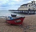
Fishing boats on Bognor Regis beach
-
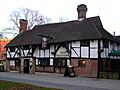
The Old Punch Bowl pub in Crawley
-
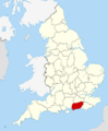
West Sussex within England
-
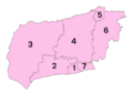
Districts of West Sussex
-
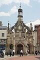
Chichester Market Cross
-
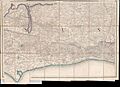
1813/54 one inch to the mile OS map
-
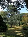
Wakehurst Place Gardens, Ardingly
See also
 In Spanish: Sussex Occidental para niños
