
County Dublin facts for kids
Quick facts for kids
County Dublin
Contae Bhaile Átha Cliath
|
||
|---|---|---|
|
||
| Nickname(s):
The Pale (Others)
|
||
| Motto(s):
Irish: Beart do réir ár mbriathar
"Action to match our speech" |
||

County Dublin shown darker on the green of Ireland with Northern Ireland in pink
|
||
| Country | Ireland | |
| Province | Leinster | |
| Region | Eastern and Midland | |
| Established | 1190s | |
| County town | Dublin | |
| Area | ||
| • Total | 922 km2 (356 sq mi) | |
| Area rank | 30th | |
| Highest elevation
(Kippure)
|
757 m (2,484 ft) | |
| Population
(2016)
|
1,345,402 | |
| • Rank | 1st | |
| • Density | 1,459/km2 (3,780/sq mi) | |
| Demonym(s) | Dubliner Dub |
|
| Time zone | UTC±0 (GMT) | |
| • Summer (DST) | UTC+1 (IST) | |
| Eircode routing keys |
D01–D18, D6W, D20, D22, D24, A41, A42, A45, A94, A96, K34, K45, K67, K78
|
|
| Telephone area codes | 01 | |
| Vehicle index mark code |
D | |

County Dublin (Irish: Contae Bhaile Átha Cliath) is one of Ireland's 32 traditional counties. It is located on the east coast of the island, in the province of Leinster.
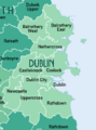
The county is now split into four local government areas: Dublin City, Dún Laoghaire–Rathdown, Fingal and South Dublin. These three new counties were created in 1994.
Dublin is Ireland's most populated county. In 2016, over 1.345 million people lived here. This is about 27% of the total population of the Republic of Ireland. Dublin city is the capital and largest city in the Republic of Ireland. About 9 out of 10 people in County Dublin live in Dublin city or its suburbs. There are also other big towns like Swords, Rush, Donabate and Balbriggan in the north of the county.
Dublin is the third smallest county by land area. It shares borders with Meath to the west and north, Kildare to the west, and Wicklow to the south. The Irish Sea is to the east. The southern part of the county has the Dublin Mountains. These mountains are about 757 metres (2,500 feet) high. They have many valleys, lakes, and forests.
The east coast has several bays, including Rogerstown Estuary, Broadmeadow Estuary, Baldoyle Bay and Dublin Bay. The northern part of the county, called Fingal, has both busy suburban towns and flat, fertile farmland. This farmland is important for growing crops.
Dublin is the oldest county in Ireland. It was the first area to be officially organised after the Norman invasion in the late 1100s. Even though it's no longer a single administrative county, people still call it County Dublin. It has a strong identity in popular culture.
Contents
Getting Around County Dublin
.png)


County Dublin has the oldest and most developed transport system in Ireland. The Dublin and Kingstown Railway opened in 1834. It was Ireland's first railway line. This line, from Westland Row to Dún Laoghaire, was meant for cargo. But it became very popular with passengers. It was the world's first commuter railway line. This line is still used today, making it the oldest commuter route in the world.
The National Transport Authority (NTA) manages public transport in Dublin. The main parts of the public transport system are the Dublin Suburban Rail, the Luas (a tram system), and the bus network.
- There are six commuter train lines in Dublin. Iarnród Éireann runs these lines. Five of them connect Dublin to towns further away. The sixth line, called Dublin Area Rapid Transit (DART), is electric. It serves Dublin and northern Wicklow.
- The Luas tram system started in 2004 with two separate lines. More extensions opened later, and a link between the lines opened in 2017.
- Long ago, Dublin had a large tram system. It started in 1871 and had over 97 km (60 miles) of tracks. It was very modern for its time. But over the years, buses became more popular, and the trams stopped running by 1949. The last tram, to Howth, ran until 1959.
Dublin Bus is the biggest bus company in the county. It carried 138 million passengers in 2019. For many parts of Dublin, especially west Dublin, buses are the only public transport option. Other smaller private bus companies also operate in County Dublin. Bus Éireann provides longer routes to towns and villages outside Dublin city.
Sometimes, public transport in Dublin can get very busy, especially during peak hours. In 2019, Dublin was ranked as one of the most congested cities in the world.
The M50 is a 45.5 km (28 mile) motorway that goes around Dublin city. It is the busiest motorway in Ireland. It's a central point for Dublin's and Ireland's motorway network. Most main roads to other cities start from the M50. The M50 was built in different sections over 27 years, from 1983 to 2010.
For international travel, about 1.7 million passengers travel by ferry through Dublin Port each year. Dublin Airport is Ireland's largest airport. In 2019, 32.9 million passengers used it. This made it Europe's 12th-busiest airport.
People of County Dublin
Population Figures
| Historical population | ||
|---|---|---|
| Year | Pop. | ±% |
| 1500 | 14,755 | — |
| 1510 | 23,471 | +59.1% |
| 1550 | 21,678 | −7.6% |
| 1580 | 20,345 | −6.1% |
| 1585 | 20,224 | −0.6% |
| 1600 | 24,556 | +21.4% |
| 1610 | 12,567 | −48.8% |
| 1653 | 18,847 | +50.0% |
| 1659 | 21,827 | +15.8% |
| 1672 | 55,678 | +155.1% |
| 1680 | 101,414 | +82.1% |
| 1690 | 145,219 | +43.2% |
| 1700 | 161,234 | +11.0% |
| 1710 | 173,690 | +7.7% |
| 1720 | 205,111 | +18.1% |
| 1725 | 212,670 | +3.7% |
| 1735 | 209,785 | −1.4% |
| 1745 | 217,666 | +3.8% |
| 1755 | 235,799 | +8.3% |
| 1765 | 244,103 | +3.5% |
| 1771 | 255,297 | +4.6% |
| 1775 | 271,475 | +6.3% |
| 1781 | 285,799 | +5.3% |
| 1788 | 291,433 | +2.0% |
| 1790 | 297,644 | +2.1% |
| 1801 | 300,345 | +0.9% |
| 1811 | 305,766 | +1.8% |
| 1813 | 311,798 | +2.0% |
| 1816 | 318,760 | +2.2% |
| 1821 | 335,892 | +5.4% |
| 1831 | 380,167 | +13.2% |
| 1841 | 372,773 | −1.9% |
| 1851 | 405,147 | +8.7% |
| 1861 | 410,252 | +1.3% |
| 1871 | 405,262 | −1.2% |
| 1881 | 418,910 | +3.4% |
| 1891 | 419,216 | +0.1% |
| 1901 | 448,206 | +6.9% |
| 1911 | 477,196 | +6.5% |
| 1926 | 505,654 | +6.0% |
| 1936 | 586,925 | +16.1% |
| 1946 | 636,193 | +8.4% |
| 1951 | 693,022 | +8.9% |
| 1956 | 705,781 | +1.8% |
| 1961 | 718,332 | +1.8% |
| 1966 | 795,047 | +10.7% |
| 1971 | 852,219 | +7.2% |
| 1979 | 983,683 | +15.4% |
| 1981 | 1,003,164 | +2.0% |
| 1986 | 1,021,449 | +1.8% |
| 1991 | 1,025,304 | +0.4% |
| 1996 | 1,058,264 | +3.2% |
| 2002 | 1,122,821 | +6.1% |
| 2006 | 1,187,176 | +5.7% |
| 2011 | 1,270,603 | +7.0% |
| 2016 | 1,345,402 | +5.9% |
.jpeg)

In 2016, the population of Dublin was 1,345,402 people. This was a 5.7% increase since 2011. The county's population first went over 1 million in 1981. It is expected to reach between 1.5 million and 1.7 million by 2031.
Dublin is Ireland's most populated county. It has held this spot since 1926. Dublin has more than double the population of County Antrim and two and a half times that of Cork. About 20.5% of Ireland's population lives in County Dublin.
With an area of just 922 square kilometres (356 square miles), Dublin is the most densely populated county in Ireland. There are 1,459 people per square kilometre. This is nearly 7 times higher than the next most densely populated county.
Many people born in Dublin have moved to nearby counties. In 2016, about 25.8% of Dubliners lived outside County Dublin. However, 880,457 Dublin natives still live within the county. This is about 66.8% of the population.
Dublin has the highest number of international residents in Ireland. About 21% of the county's population was born outside the Republic of Ireland.
People from Other Countries
| Main immigrant groups, 2016 | |
| Country of birth | Population |
|---|---|
| 55,391 | |
| 33,751 | |
| 18,119 | |
| 11,572 | |
| 9,865 | |
| 9,013 | |
| 8,485 | |
| 8,223 | |
| 7,313 | |
| 7,290 | |
| 6,770 | |
| *Includes Hong Kong SAR | |

More than one-fifth (20.8%) of County Dublin's population was born outside the Republic of Ireland. The largest groups of immigrants in Dublin are from other European countries. There are also many people from India, Brazil, the United States, and East Asia living in the county.
The largest groups of foreign-born residents are from the United Kingdom and Poland. After Poland joined the EU in 2004, many Poles moved to Dublin. Romanians are also a fast-growing group in Dublin.
Outside of Europe, Brazil and India are growing sources of foreign residents. Many Brazilian students come to study in Ireland. The number of people from India has also grown. This is partly because big tech companies like Microsoft, Google, and Facebook have offices in Dublin.
Different Backgrounds
In 2016, most people in County Dublin identified as White (87.6%). This included 75.5% White Irish and 11.7% from other White backgrounds. About 0.5% were Irish Travellers.
Dublin has the largest non-white population in Ireland. About 8.3% of the county's residents are non-white. Nearly half (44.7%) of Ireland's Black residents live in County Dublin. Also, 42.8% of Ireland's multiracial population lives here.
Religion in Dublin
| Religion in Dublin (2016) | ||||
|---|---|---|---|---|
| religion | percent | |||
| Roman Catholicism | 68.9% | |||
| No religion | 14.4% | |||
| Other Christian | 7.0% | |||
| Islam | 2.2% | |||
| Hinduism | 0.6% | |||
| Other stated religions | 2.9% | |||
| Not Stated | 4.1% | |||
.jpg)
The largest religion in Dublin is Roman Catholicism, with 68.9% of the population in 2016. Other Christian groups, like the Church of Ireland, Eastern Orthodox, and Presbyterian, make up 7.0% of the population. In total, Christians are 75.9% of the county's population.
Dublin city has the highest percentage of people who say they have no religion (18.1%). For the whole county, 14.4% of people said they had no religion. This is the highest percentage in Ireland.
After Christianity, Islam is the largest religion, with 2.2% of the population. Other non-Christian religions include Hinduism (0.62%), Buddhism (0.32%), and Judaism (0.11%). County Dublin is home to over half of Ireland's Hindu, Jewish, and Eastern Orthodox residents. It also has almost half of its Islamic and Buddhist residents.
Dublin has been a Christian diocese since 1028. Historically, County Dublin was a strong centre for Protestantism in Ireland outside of Ulster.
Between 2011 and 2016, the fastest growing religions in Dublin were Evangelicalism, Eastern Orthodox, Hinduism, and Islam.
Dublin's City Areas
Dublin City Centre
The area managed by Dublin City Council is the main part of the city. It covers 117.8 square kilometres. This includes central suburbs like Terenure and Donnybrook in the south, and Ballymun and Donaghmede in the north. In 2016, 554,554 people lived in this area.
Dublin City and Suburbs
This is a larger urban area that includes the busy parts surrounding Dublin city centre. It covers 317.5 square kilometres. In 2016, it had about 1,173,179 people. This is about 87% of County Dublin's population.
Dublin Metropolitan Area
This area includes towns outside the city boundaries, like Swords, Lusk, Rush, and Malahide in North County Dublin. It also includes towns from nearby counties like Naas and Maynooth in County Kildare, and Bray in County Wicklow.
Greater Dublin Area
The Greater Dublin Area (GDA) is a planning area that includes County Dublin and its three neighbouring counties: Kildare, Meath, and Wicklow.
This area has a population of 1.9 million people. It covers 6,986 square kilometres. It contains 40% of the population of the Republic of Ireland.
| Statistical Area | Population (2016) | Area (km2) | Density (per km2) | Local Authorities |
|---|---|---|---|---|
| Dublin City | 554,554 | 117.8 | 4,708 | Dublin |
| Dublin City and suburbs | 1,173,179 | 317.5 | 3,695 | Dublin, Fingal, South Dublin, Dún Laoghaire-Rathdown |
| County Dublin | 1,345,402 | 922 | 1,459 | Dublin, Fingal, South Dublin, Dún Laoghaire-Rathdown |
| Dublin Metropolitan Area | 1,417,700 | 1,000 | 1,418 | Dublin, Fingal, South Dublin, Dún Laoghaire-Rathdown, Meath, Kildare, Wicklow |
| Greater Dublin Area | 1,904,806 | 6,986 | 273 | Dublin, Fingal, South Dublin, Dún Laoghaire-Rathdown, Meath, Kildare, Wicklow |
Towns and Urban Areas
An "Urban Area" is a town with more than 1,500 people. Dublin is the most urbanised county in Ireland. In 2016, 97.75% of its residents lived in urban areas.
The western suburbs of Dublin city, like Tallaght and Blanchardstown, have grown a lot. These areas now have populations similar to Galway city.
|
Largest cities or towns in County Dublin
Source: |
||
|---|---|---|
| Rank | Pop. | |
| 1 | Dublin | 554,554 |
| 2 | Tallaght | 76,119 |
| 3 | Blanchardstown | 74,478 |
| 4 | Swords | 39,248 |
| 5 | Dún Laoghaire | 26,525 |
| 6 | Balbriggan | 21,722 |
| 7 | Malahide | 16,550 |
| 8 | Skerries | 10,043 |
| 9 | Rush | 9,943 |
| 10 | Portmarnock | 9,466 |
Dublin's Economy
.png)
The Dublin Region has the biggest and most developed economy in Ireland. It makes up over two-fifths (40%) of the country's total economic output (Gross Domestic Product or GDP). In 2018, Dublin's economy was worth about €139.14 billion. This is larger than the economies of many countries.
Dublin's GDP per person is €103,248. This is one of the highest in the European Union. Dublin also has a very high Human Development Index (0.963). This means it's one of the most developed places in the world for things like how long people live, how much education they get, and how much money they earn.
Wealth in Dublin

In 2017, the average money people had to spend in Dublin was €23,864. This was 115.2% of the national average. Dublin has the highest total household income in Ireland, estimated at €46.8 billion in 2017.
Many important political, educational, cultural, and media places are south of the River Liffey in Dublin city. Areas like Dún Laoghaire, Dalkey, and Killiney in the south have always been wealthy. Dún Laoghaire–Rathdown often has the highest house prices in Ireland.
This has led to a common idea of a "Northside" (less wealthy) and "Southside" (wealthier) divide in Dublin. People often joke about this difference in Irish comedy and stories. However, studies show that many wealthy areas like Clontarf and Malahide are in the north. Also, some less wealthy areas like Jobstown and Clondalkin are in the south. This means the real economic difference might be more between the older coastal areas and the newer western suburbs.
Money and Business

Dublin is a major financial hub in Europe and globally. About 200 of the world's top financial companies have offices here. In 2017 and 2018, Dublin was ranked among the top financial centres in Europe and the world.
In the 1980s, parts of central Dublin were run down. So, the Irish government created a special business area called the International Financial Services Centre (IFSC) in 1987. This area offered lower taxes for companies. The IFSC has grown a lot and is now a big part of the Dublin Docklands.
After the UK left the European Union (Brexit) in 2016, many companies like Barclays and Bank of America moved some of their business from London to Dublin. This was to keep their access to the EU market. Experts believe Dublin's financial sector will grow by about 25% because of Brexit.

Industries and Energy

_(32979900775).jpg)
Dublin's economy gets a lot of investment from both Irish and foreign companies. In 2018, Dublin was named the most attractive large city in the world for foreign investment. It's also known as one of the most business-friendly cities.
The economy focuses on:
- Financial services (banks, etc.)
- Medicines and biotechnology
- Information technology
- Logistics (moving goods)
- Professional services
- Agriculture
- Tourism
IDA Ireland, a government agency, helps bring foreign companies to Ireland. It was founded in Dublin in 1949.
Dublin has four power plants, all in the docklands area. They produce about 12.5% of Ireland's electricity. The tall, unused Poolbeg chimneys are the tallest structures in the county.
Shipping has been important in Dublin for a long time because of its location on a bay and a river. Dublin Port is the largest and busiest port in Ireland. It handles 50% of the Republic of Ireland's trade.
Some of Ireland's biggest companies have their main offices in Dublin. These include banks like AIB and Bank of Ireland, and companies like Ryanair (Europe's largest airline) and Diageo (makers of Guinness).
Tourism in Dublin

County Dublin gets the most international tourists in Ireland. This is because Dublin city is the largest city and a major transport hub. It's also the most popular place for Irish people to visit.
In 2017, Dublin had almost 6 million international tourists and nearly 1.5 million Irish tourists. Most international flights arrive at Dublin Airport. Most passenger ferries arrive at Dublin Port. The tourism industry in the county is worth about €2.3 billion each year.
Many of Ireland's top tourist attractions are in County Dublin.
- The Guinness Storehouse is Ireland's most visited attraction. It had 1.7 million visitors in 2019.
- Other popular places include Dublin Zoo, the Book of Kells at Trinity College, and St Patrick's Cathedral.
- Free attractions include the National Gallery of Ireland, the National Botanic Gardens, and the National Museum of Ireland.
Farming in Dublin
.jpg)

Even though Dublin has the smallest farmed area, it's a big producer of farm goods. Dublin is the largest producer of fruit and vegetables in Ireland. It's also a major producer of oilseed rape and has a significant fishing industry.
The Fingal area alone produces 55% of Ireland's fresh produce. This includes fruits, berries, apples, lettuces, and many vegetables. In 2020, the total value of Dublin's farm produce was €205 million. Fish caught in the county are worth another €20 million.
About 41% of the county's land (38,576 hectares) is used for farming. Because Dublin city and its towns are growing, farmland is under pressure from new buildings. Between 1991 and 2010, the amount of farmland in the county decreased by 22.9%.
Dublin has a small forestry industry, mostly in the southern mountains. Most forests are owned by the national forestry company, Coillte.
Dublin has 810 farms. The average farm size is 47.6 hectares, which is the largest average farm size in Ireland. About 9,400 people in the county work in farming or food processing. Many food and drink companies have offices or factories in Dublin. These include Mondelez, Coca-Cola, Mars, and Diageo.
Sports in Dublin

Gaelic Games
Dublin is strong in both hurling/camogie and Gaelic football. The Dublin county board manages Gaelic games here. The county's GAA crest, created in 2004, shows symbols for Dublin's four areas:
- The castle for Dublin city.
- The raven for Fingal.
- The Viking longboat for Dún Laoghaire–Rathdown.
- The book of Saint Tamhlacht for South Dublin.
In Gaelic football, the Dublin team is very successful. They have won the Leinster Senior Football Championship 60 times. Nationally, they are second only to Kerry for All-Ireland Senior Football Championship titles. Dublin and Kerry are big rivals. Dublin has won the All-Ireland 30 times, including a record 6 wins in a row from 2015 to 2020.
In hurling, the Dublin team is the second most successful in Leinster, after Kilkenny. They have won 24 Leinster hurling titles. However, they have won fewer All-Ireland Senior Hurling Championship titles, with 6 wins. Their most recent All-Ireland hurling win was in 1938.
Local Gaelic football and hurling clubs in Dublin compete in the Dublin Senior Football Championship and Dublin Senior Hurling Championship. These started in 1887. St Vincents (Marino) and Faughs (Templeogue) are very successful clubs. Four Dublin football teams have won the All-Ireland Senior Club Football Championship. Recently, Dalkey's Cuala hurling club won back-to-back All-Irelands in 2017 and 2018.
Soccer
.jpg)
.jpeg)
Soccer is one of the most popular sports in County Dublin. While Gaelic games are watched more, soccer is played by more people. There are over 200 amateur soccer clubs here.
Dalymount Park in Phibsborough is known as the "home of Irish football." It's the country's oldest stadium and was the national team's home ground until 1990. The Republic of Ireland national football team now plays at the 52,000-seat Aviva Stadium. This stadium was built in 2010. It hosted the 2011 UEFA Europa League Final.
Five League of Ireland soccer clubs are based in County Dublin:
- Bohemians F.C.
- Shamrock Rovers
- St Patrick's Athletic
- University College Dublin
- Shelbourne
Shamrock Rovers, now based in Tallaght, are the most successful club in Ireland. They have won 19 League of Ireland titles. They were also the first Irish team to reach the group stages of a European competition in 2011. The Bohemians–Shamrock Rovers rivalry is the most intense derby match in Dublin. It's a rivalry between the Northside and Southside clubs.
| Club | League | Stadium (capacity) | Established | Titles |
|---|---|---|---|---|
| Bohemians | LOI Premier Division | Dalymount Park (3,400) | 1890 | 11 |
| St Patrick's Athletic | Richmond Park (5,340) | 1929 | 8 | |
| Shamrock Rovers | Tallaght Stadium (8,000) | 1899 | 19 | |
| Shelbourne | Tolka Park (4,400) | 1895 | 13 | |
| University College Dublin | UCD Bowl (3,000) | 1895 | 0 |
Other Sports
_-_20190511195853.jpg)
Rugby Union is the third most popular sport in the county. Leinster Rugby plays its home games at the RDS Arena and the Aviva Stadium. County Dublin has 13 senior rugby clubs.
Other popular sports include:
- Cricket: Dublin has two international cricket grounds. The Phoenix Cricket Club, founded in 1830, is the oldest in Ireland.
- Hockey: Women's field hockey is growing. Many players on the Ireland women's national field hockey team are from Dublin clubs.
- Golf: Dublin has many golf courses. Three-time major winner Pádraig Harrington is from Rathfarnham.
- Tennis: The Fitzwilliam Lawn Tennis Club is one of the world's oldest.
- Horse racing: There is a horse racing track at Leopardstown.
- Boxing: The national boxing stadium is in Dublin.
- Basketball: The national basketball arena is also in Dublin.
Learning in Dublin


In Ireland, the government controls most of the money spent on education. Local councils help with things like school meals and libraries.
County Dublin has hundreds of primary and secondary schools. Most teach in English. There are also international schools that teach in other languages. Many students attend gaelscoileanna (Irish-language primary schools) and gaelcholáistí (Irish-language secondary schools). These Irish-language schools often have very good college acceptance rates.
The Roman Catholic Church owns most schools in Dublin. Catholic students often get preference in crowded areas. This has led to a growing demand for non-religious and mixed-gender schools.
Many private secondary schools in Dublin are still single-sex. They often have religious connections. Newer private schools are usually non-religious and mixed-gender.
Dublin has four public universities and many other colleges. Several of Dublin's universities are ranked among the top 2% of all universities in the world.
Here are some of Dublin's largest third-level (college) institutions:
_p049_THE_COLLEGE_OF_SURGEONS.jpg)
- Dublin Business School (DBS)
- Dublin City University (DCU)
- Dún Laoghaire Institute of Art, Design and Technology (IADT)
- Griffith College Dublin (GCD)
- National College of Ireland (NCI)
- Royal College of Surgeons in Ireland (RCSI)
- Technological University Dublin (TUD)
- Trinity College Dublin (TCD)
- University College Dublin (UCD)
Images for kids
-
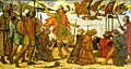
Viking fleet landing at Dublin, 841
-
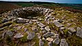
Prehistoric passage tomb at Tibradden
-
Norse-Gael Kingdom of Dublin in the 10th Century
-

Burnt out buildings following the Sack of Balbriggan, September 1920
-

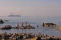
Sunset over Skerries
-
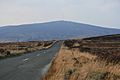
At an elevation of 757 metres (2,484 ft), Kippure is the highest point in the county
-
Summertime bathers at Sandycove
-

December snow at Killiney
-
Dublin's postal subdivisions after the implementation of Eircode. They include the city's historic postal districts and the newer A and K Dublin codes.
-
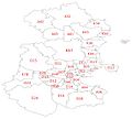
The Baronies of County Dublin
-

Three Rock Mountain, Dublin, looking towards Bray Head
-
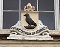
Remnant of the county's historic coat of arms on Parnell Square
-

Festival at Marlay Park
-

Killiney Bay


.jpg)

.png)


.jpg)

_(25730106934).jpg)
See also
 In Spanish: Condado de Dublín para niños
